

Isle of Whithorn
Encyclopedia
Isle of Whithorn is one of the most southerly villages and seaports in Scotland, lying on the coast, north east of Burrow Head, about three miles from Whithorn
. Whithorn, (Taigh Mhàrtainn in Gaelic
), is a former royal burgh
in Dumfries and Galloway
, with which the Isle of Whithorn is frequently incorrectly amalgamated or confused. It lies about thirteen miles south of Wigtown
. The village is the location of the long ruined 13th century Saint Ninian
's Chapel, previously a chapel linked to Whithorn Priory
and a stopping off point for pilgrims landing on Isle Head and making their way to Whithorn. No longer a true island, John Ainslie's maps as late as 1782 and 1821 do show the Isle as an island. The main street was originally a causeway, with the harbour located on what was then the true Isle.
The Isle has a long history of habitation, for example a survey of the ground between the Isle village and Saint Ninian's Chapel revealed Clearance cairn
s and cultivation furrows, as well as the remains of a rectangular building occupying the crest of the low hill immediately to the West of the chapel, with possible steps leading downhill towards the East.
Fishing is widely available on the lochs, local rivers Bladnoch and Cree
, and on the sea itself by boat or from the shore. There are numerous trails and quiet roads for walking, horse riding or cycling. Signposted by the Whithorn Pilgrimage Trust, The Pilgrim's Way follows a route southwards from the Southern Upland Way through The Machars, passing through New Luce
and the early Christian holy sites of Glenluce Abbey
, the White Loch, Whithorn, Isle of Whithorn and St Ninian's Cave. The main part of the route from Glenluce to Whithorn is 25 miles (40 km) long.
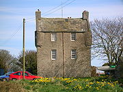 The castle, called "The Isle" in the 19th century, stands on elevated ground near the Drummulin Burn. The building is comparatively small and is nearly square in plan, although the principle of an 'L' shaped arrangement is retained. In the early 19th century it was the residence of the Superintendent of the Coastguard, Sir John Reid. The 'Captain's Garden' is an extension into the harbour, now with several houses on it, but originally a garden associated with the castle. Still called the Captain's Garden it is decorated with simulated man o'war gun ports. A one story servants quarters and outhouse is attached to the east of the castle. Above the door of these quarters is a stone with the initials of Patrick Houston of Drummaston and his wife Margaret Gordon, together with the likely date of construction, 1674. This stone has been moved from the old entrance door of the main building. The angle turrets on the second floor are carried on three plain corbels and do not show at all in the inside of the building. A Gothic-style porch was once attached to the Drumelan burn side of the castle.
The Bysbie corn mill was located on the other side of the Drummulin Burn from the castle and a sizeable mill pond and sluice supplied the water power; the mill remains lie behind the Queen's Arms Hotel. A Chalybeate
'Spa Well' was located below the castle as shown by the 1850s 6 inch to the mile OS map.
in the River Garnock
near Kilwinning
. He converted the Southern Picts and therefore journeyed through many areas in southern Scotland.
which sank in a storm off the Isle of Man
in January 2000.
The Isle's most familiar landmark is the square, white tower that has been a navigational aid for hundreds of years. From here there are views of the Kirkcudbright coast, the whole of the northern range of the English Lake District mountains, and to the south the rounded, mountainous form of the Isle of Man. During the Second World War this was the site of a tracking station for anti-aircraft gunnery practice. The set up was that an aircraft flew up and down in front of the guns, which would try to bring it down. Initially, radio-controlled 'Queen Bee' aircraft were used, and the flat concrete foundation by the white tower on the cairn, now the location of the Solway Harvester memorial stone, was laid down for one of the control huts. The memorial stone to the Solway Harvester is in the form of an anchor set in a granite block.
As indicated, Isle Head has a multivallate fort consisting of 3 ramparts and 2 ditches with a probable 4th rampart now reduced to a slight scarp. On the seaward side of the promontory are intermittent stretches of rubble linking and utilising natural outcrops of rock and in the south-east corner inner and outer faces, indicating the footings of a wall up to 3.1m wide. On the levelled summit area are slight indications of rubble walling and artificial scarping on the south and east sides and in the north-east corner are the possible remains of a hut circle.
A small block of rig on is clearly visible on Isle Head, lying between the path leading to the promontory and the ramparts and ditch of the Iron Age
fort. The furrows, are orientated from NE to SW across the promontory.
A pier was first erected in 16th century, but a more substantial structure was erected in 1790 to advance commerce, such as the trade with Whitehaven
and other English ports. In 1969 the pier was badly damaged by storm and was only rebuilt after a prolonged campaign by local people. The perch is a reef of rock that runs out from the west side of the mouth of the Isle bay; it can be a hazard to craft coming into the Isle and for many years the end was marked with an iron pole. In the 19th century the Isle also had strong trade links with Ireland and the Isle of Man, and ships were being built as well as sailed from here. The Countess of Galloway, the steam packet once regularly sailed from here to Liverpool. By the end of the 20th century trading vessels had given way almost entirely to yachts and other leisure craft.
The Wigtown Bay Sailing Club welcomes all visiting yachtsmen whether they arrive by sea or by land with trailered boats. The Clubhouse is situated on the Harbour and has all the usual facilities. The Harbour dries 3 hours either side of high water, and there is a dedicated visitors' berth at the outer end of the quay. There are also two slipways for launching trailer boats or dinghies, one of which is at the inner end of the quay and is sheltered in all weathers. The other, which gives access into the bay, can be used at virtually any state of the tide. The club is active throughout the summer with dinghy or cruiser races organised for most weekends and some races mid-week.
An unusual feature of the harbour was a fish trap; a wall or dyke running across part of the upper portion of the inlet which trapped fish as the tide went out. This was still marked as late as the 1850s on the OS map.
Whithorn
Whithorn is a former royal burgh in Dumfries and Galloway, Scotland, about ten miles south of Wigtown. The town was the location of the first recorded Christian church in Scotland, Candida Casa : the 'White [or 'Shining'] House', built by Saint Ninian about 397.-Eighth and twelfth centuries:A...
. Whithorn, (Taigh Mhàrtainn in Gaelic
Scottish Gaelic language
Scottish Gaelic is a Celtic language native to Scotland. A member of the Goidelic branch of the Celtic languages, Scottish Gaelic, like Modern Irish and Manx, developed out of Middle Irish, and thus descends ultimately from Primitive Irish....
), is a former royal burgh
Royal burgh
A royal burgh was a type of Scottish burgh which had been founded by, or subsequently granted, a royal charter. Although abolished in 1975, the term is still used in many of the former burghs....
in Dumfries and Galloway
Dumfries and Galloway
Dumfries and Galloway is one of 32 unitary council areas of Scotland. It was one of the nine administrative 'regions' of mainland Scotland created in 1975 by the Local Government etc. Act 1973...
, with which the Isle of Whithorn is frequently incorrectly amalgamated or confused. It lies about thirteen miles south of Wigtown
Wigtown
Wigtown is a town and former royal burgh in the Machars of Galloway in the south west of Scotland. It lies south of Newton Stewart and east of Stranraer. It has a population of about 1,000...
. The village is the location of the long ruined 13th century Saint Ninian
Saint Ninian
Saint Ninian is a Christian saint first mentioned in the 8th century as being an early missionary among the Pictish peoples of what is now Scotland...
's Chapel, previously a chapel linked to Whithorn Priory
Whithorn Priory
Whithorn Priory is located in Wigtownshire, Galloway. It was founded about the middle of the twelfth century, in the reign of David I, by Fergus, Lord of Galloway, with Gille Aldan, Bishop of Galloway, for Premonstratensian Canons, referred colloquially in Britain as the White Canons.The canons of...
and a stopping off point for pilgrims landing on Isle Head and making their way to Whithorn. No longer a true island, John Ainslie's maps as late as 1782 and 1821 do show the Isle as an island. The main street was originally a causeway, with the harbour located on what was then the true Isle.
The Isle has a long history of habitation, for example a survey of the ground between the Isle village and Saint Ninian's Chapel revealed Clearance cairn
Clearance cairn
A Clearance Cairn is an irregular and unstructured collection of fieldstones which have been removed from arable land or pasture to allow for more effective agriculture and collected into a usually low mound or cairn. Commonly of Bronze Age origins, these cairns may be part of a cairnfield where...
s and cultivation furrows, as well as the remains of a rectangular building occupying the crest of the low hill immediately to the West of the chapel, with possible steps leading downhill towards the East.
The community and amenities
The village has two pubs, the Queen's Arms and the Steam Packet Inn. A Community Council represents the village and a Church of Scotland church, previously a Free Kirk, sits on the old boatyard, a site extending into the harbour and threatened at exceptionally high tides. There is a bowling club, a basic football pitch and two play areas for the young. The village hall is well used - in August 2008, the community took over management control of this facility and it is now completely refurbished and home to Scotland's most southerly cinema 'Machars Movies'. A post office and shop are situated on the roadside near the Queen's Arms. Also on the harbour there is a fish shop/general store called Isle Sea Foods, where you can buy fresh fish and also groceries. Upstairs in the building there is a launderette, a toilet and shower facilities. The old village school is now a private house, overlooking the Stinking Port, the bay on the other side of the Isle promontory. The war memorial sits at the North end of the village on the main Street to Whithorn. It is a granite memorial overlooking the Bowling Green with twelve WW1 names on it and five WW2 names. The regiments and ships are given for the First War only.Fishing is widely available on the lochs, local rivers Bladnoch and Cree
Cree
The Cree are one of the largest groups of First Nations / Native Americans in North America, with 200,000 members living in Canada. In Canada, the major proportion of Cree live north and west of Lake Superior, in Ontario, Manitoba, Saskatchewan, Alberta and the Northwest Territories, although...
, and on the sea itself by boat or from the shore. There are numerous trails and quiet roads for walking, horse riding or cycling. Signposted by the Whithorn Pilgrimage Trust, The Pilgrim's Way follows a route southwards from the Southern Upland Way through The Machars, passing through New Luce
New Luce
New Luce is a quiet picturesque village in the Scottish unitary council area of Dumfries and Galloway. It has a shop, pub and two bridges. In the summer it has a popular gala day. The coast to coast walk, the Southern Upland Way, passes close to the village. New Luce is surrounded by good walking...
and the early Christian holy sites of Glenluce Abbey
Glenluce Abbey
Glenluce Abbey, near to Glenluce, Scotland, was a Cistercian monastery called also Abbey of Luce or Vallis Lucis and founded around 1190 by Rolland or Lochlann, Lord of Galloway and Constable of Scotland...
, the White Loch, Whithorn, Isle of Whithorn and St Ninian's Cave. The main part of the route from Glenluce to Whithorn is 25 miles (40 km) long.
Isle of Whithorn Castle
The Bysbie corn mill was located on the other side of the Drummulin Burn from the castle and a sizeable mill pond and sluice supplied the water power; the mill remains lie behind the Queen's Arms Hotel. A Chalybeate
Chalybeate
Chalybeate waters, also known as ferruginous waters, are mineral spring waters containing salts of iron.-Name:The word "chalybeate" is derived from the Latin word for steel, "chalybs", which follows from the Greek word "khalups"...
'Spa Well' was located below the castle as shown by the 1850s 6 inch to the mile OS map.
Saint Ninian's Chapel
The chapel was repaired and partly rebuilt in 1898 by the Marquess of Bute, its main features being preserved. The present ruins are rectangular, measuring internally 31' x 16' 6". This building was probably erected to replace a 12th-early 13th century chapel, whose foundations were found during excavations and consisted of a nave, 17' 6" x 16' 6" with a square chancel. The chapel stood within a contemporary enclosure wall, part of which is still standing. An outer enclosure may have once existed, best seen in oblique sunlight, defining a roughly oval area 100' x 110'. This outer enclosure may be of the Celtic period. There are no records of the chapel's use as a burial ground. Saint Ninian is chiefly remembered at Whithorn, however many places in Scotland are associated with his name, such as Saint Ninian's IsleEglinton Country Park
Eglinton Country Park is located in the grounds of the old Eglinton Castle estate, Kilwinning, North Ayrshire, Scotland . Eglinton Park is situated in the parish of Kilwinning, part of the former district of Cunninghame, and covers an area of 400 hectares...
in the River Garnock
River Garnock
The River Garnock, the smallest of Ayrshire's six principal rivers, has its source on the southerly side of the Hill of Stake in the heart of the Clyde Muirshiel Regional Park. About a mile and a half south of this starting point the untested stream tumbles over the Spout of Garnock, the highest...
near Kilwinning
Kilwinning
Kilwinning is a historic town in North Ayrshire, Scotland. It is known as The Crossroads of Ayrshire. The 2001 Census recorded it as having a population of 15,908.-History:...
. He converted the Southern Picts and therefore journeyed through many areas in southern Scotland.
Isle Head
This promontory is nearly bisected by Chapel Port east and west. The artificial ditch of the old fort is still clearly visible on the approach to Isle Head. A witness cairn was erected in 1997 to commemorate the arrival of the Christian missionary St Ninian to these shores and pilgrims are encouraged to place stones with personal messages onto a rock cairn. These cairns are sited in the remains of a building used to house the Isle of Whithorn lifeboat. The building had a roof until well after the Second World War although the station was closed in 1919, when a motor lifeboat was placed on station at Kirkcudbright. The Lifeboat Station was set up in 1869. During the 50 years that the lifeboat station was operating there were three lifeboats: Charlie Peake (1869–1886), 7 launches and 10 lives saved. Henry and John Leighton (1886–1901), 12 launches and 22 lives saved. George and Margaret (1901–1919), six launches and six lives saved. The Solway Harvester Seat is a granite-hewn and is one of two local tributes to the seven-strong local crew of the fishing boat Solway HarvesterSolway Harvester
The Solway Harvester is a scallop dredger from Kirkcudbright, Scotland which sank off the coast of Ramsey, Isle of Man in heavy storms on 11 January 2000. Following salvage, the damaged ship was taken to Douglas, Isle of Man, where she remains as of August 2011.-Career and sinking:The Solway...
which sank in a storm off the Isle of Man
Isle of Man
The Isle of Man , otherwise known simply as Mann , is a self-governing British Crown Dependency, located in the Irish Sea between the islands of Great Britain and Ireland, within the British Isles. The head of state is Queen Elizabeth II, who holds the title of Lord of Mann. The Lord of Mann is...
in January 2000.
The Isle's most familiar landmark is the square, white tower that has been a navigational aid for hundreds of years. From here there are views of the Kirkcudbright coast, the whole of the northern range of the English Lake District mountains, and to the south the rounded, mountainous form of the Isle of Man. During the Second World War this was the site of a tracking station for anti-aircraft gunnery practice. The set up was that an aircraft flew up and down in front of the guns, which would try to bring it down. Initially, radio-controlled 'Queen Bee' aircraft were used, and the flat concrete foundation by the white tower on the cairn, now the location of the Solway Harvester memorial stone, was laid down for one of the control huts. The memorial stone to the Solway Harvester is in the form of an anchor set in a granite block.
As indicated, Isle Head has a multivallate fort consisting of 3 ramparts and 2 ditches with a probable 4th rampart now reduced to a slight scarp. On the seaward side of the promontory are intermittent stretches of rubble linking and utilising natural outcrops of rock and in the south-east corner inner and outer faces, indicating the footings of a wall up to 3.1m wide. On the levelled summit area are slight indications of rubble walling and artificial scarping on the south and east sides and in the north-east corner are the possible remains of a hut circle.
A small block of rig on is clearly visible on Isle Head, lying between the path leading to the promontory and the ramparts and ditch of the Iron Age
Iron Age
The Iron Age is the archaeological period generally occurring after the Bronze Age, marked by the prevalent use of iron. The early period of the age is characterized by the widespread use of iron or steel. The adoption of such material coincided with other changes in society, including differing...
fort. The furrows, are orientated from NE to SW across the promontory.
The harbour
The harbour has regular landings from Irish Sea shell fishing boats supplying the local processing factories. The Isle's own fleet is engaged in light trawling and lobster fishing. A number of leisure craft are kept here and the Isle is increasingly being used as a stopping off location for pleasure traffic plying the west coast, and as a launching site for trailer based craft such as small angling boats and diving RIB's.A pier was first erected in 16th century, but a more substantial structure was erected in 1790 to advance commerce, such as the trade with Whitehaven
Whitehaven
Whitehaven is a small town and port on the coast of Cumbria, England, which lies equidistant between the county's two largest settlements, Carlisle and Barrow-in-Furness, and is served by the Cumbrian Coast Line and the A595 road...
and other English ports. In 1969 the pier was badly damaged by storm and was only rebuilt after a prolonged campaign by local people. The perch is a reef of rock that runs out from the west side of the mouth of the Isle bay; it can be a hazard to craft coming into the Isle and for many years the end was marked with an iron pole. In the 19th century the Isle also had strong trade links with Ireland and the Isle of Man, and ships were being built as well as sailed from here. The Countess of Galloway, the steam packet once regularly sailed from here to Liverpool. By the end of the 20th century trading vessels had given way almost entirely to yachts and other leisure craft.
The Wigtown Bay Sailing Club welcomes all visiting yachtsmen whether they arrive by sea or by land with trailered boats. The Clubhouse is situated on the Harbour and has all the usual facilities. The Harbour dries 3 hours either side of high water, and there is a dedicated visitors' berth at the outer end of the quay. There are also two slipways for launching trailer boats or dinghies, one of which is at the inner end of the quay and is sheltered in all weathers. The other, which gives access into the bay, can be used at virtually any state of the tide. The club is active throughout the summer with dinghy or cruiser races organised for most weekends and some races mid-week.
An unusual feature of the harbour was a fish trap; a wall or dyke running across part of the upper portion of the inlet which trapped fish as the tide went out. This was still marked as late as the 1850s on the OS map.