

Los Gatos Creek (Santa Clara County, California)
Encyclopedia
The Los Gatos Creek runs 24 miles in California
through Santa Clara Valley Water District
's Guadalupe Watershed
from the Santa Cruz Mountains
northward through the Santa Clara Valley
until its confluence with the Guadalupe River
in downtown San Jose
. The Guadalupe River then continues onward into San Francisco Bay
.
The creek begins in the Santa Cruz mountains near the Santa Clara
/Santa Cruz
County border, just south of the peak Loma Prieta
. It then flows northwesterly to Lake Elsman, a reservoir owned by the San Jose Water Company, then on to Holy City
and Chemeketa Park
, then northward into the Lexington Reservoir
. The creek then flows through the Los Gatos Canyon and through the town of Los Gatos
and Vasona Reservoir
, then northeasterly through Campbell
and San Jose where it meets the Guadalupe River.
 The creek was named after the Alta California
land grant Rancho Rinconada de Los Gatos
("Corner of the Cats"), which itself was named for the cougars and/or bobcat
s that roam in the mountains above the present-day town of Los Gatos. The first settlers, a Spanish family arriving in 1839, were scouting for a homestead in the area when they heard mountain lions roaring and fighting. While frightened, they also recognized it was a good omen, for it meant water couldn't be far away. They discovered the creek and built a home in what is now Vasona Lake County Park
. On Hare's 1872 map the creek was called Arroyo de Los Gatos and Zachariah Jones called it Jones Creek at the time he laid out the town he called Jones Mill (which later became the now submerged Lexington, California
). Forbes Mill
was established by James Forbes along the creek in the 1850s; the town of Los Gatos was subsequently built around the mill.
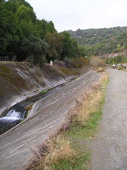
The construction of State Route 17 in the 1950s forced much of the creek through Los Gatos to be diverted into a concrete gulch. As a Caltrans magazine from the era describes it: "Included in this project is a relocation of Los Gatos Creek for a distance of 6,000 feet, requiring a concrete line channel." The Los Gatos Daily Times on Aug. 31, 1954, reported that "bulldozers have virtually completed clearing and leveling the bed of Los Gatos Creek, and preparations are readied for laying the concrete culvert."
Also in the 1950s, the construction of the James J. Lenihan Dam
formed Lexington Reservoir
, which flooded much of a small valley above Los Gatos, including the former townsites of Lexington
and Alma
. The dam and reservoir were completed in 1952, forcing the rerouting of Highway 17. When the reservoir's water level is low, the concrete bed of the old highway through those towns can be seen, along with foundations from some of the buildings. In spite of these events, much of the creek maintains its natural course and beauty.
Below Vasona Park
, Los Gatos Creek feeds percolation ponds that are part of the groundwater recharge system built by the Santa Clara Valley Water District
. North of Lark Avenue, one can also see a structure resembling a fountain, where imported water from other reservoirs is also added to Los Gatos Creek for recharge. In the 1920s, people discovered that Santa Clara Valley was sinking because of groundwater pumping. San Jose's elevation subsided
13 feet from 1910 to 1970s, correlated with a 250 feet decline in the underground water table. The valley's aquifers were also in danger of being ruined by saltwater infiltration. Local reservoirs were built to provide water for an aggressive groundwater recharge program. While simultaneously dealing with the demands of growing cities, the water district finally managed to stop further sinking by 1980s. Vasona and Lexington reservoirs were part of the effort.
use throughout. A 1952 California Department of Fish and Game
document stated that substantial steelhead runs had not been seen in Los Gatos Creek since 1937, when agricultural pumps lowered the water table throughout the Santa Clara Valley and dewatered the lower reach. However, resident trout populations had remained in the portions of the creek maintaining permanent flow, just below and above of Lexington Reservoir. Between Lake Elsman and Lexington Reservoir, the creek is pristine and closed to the public. Here, along with rainbow trout (the landlocked form of steelhead trout), beaver, bobcats, wild boar and mountain lions are now extant. The beaver were restocked to the portion of Los Gatos Creek where it enters Lexington Reservoir sometime before Spring 1992, and recently, a beaver reportedly served as "a hearty meal" for a local mountain lion. Historical evidence of beaver in the area includes reference by Captain John Sutter
who around 1840 recorded that 1,500 beaver pelts were sold "at a trifling value" by the Indians to Mission San José, the latter only 25 miles from the town of Los Gatos. Physical proof of Golden beaver in south San Francisco Bay tributaries is a Castor canadensis subauratus skull in the Smithsonian Institution
National Museum of Natural History collected by zoologist James Graham Cooper
in Santa Clara, California
on Dec. 31, 1855. Cooper lived in Mountain View, California
from October to December, 1855.
The Santa Clara Valley Water District now manages lower Los Gatos Creek so that it once again supports steelhead trout and Chinook salmon
that migrate up the Guadalupe River from San Francisco Bay. Both species have been spotted as far up the creek as Hamilton Avenue.
in the Santa Cruz Mountains
and flows west to the minor Williams Reservoir above Lake Elsman (also a reservoir formed by Austrian Dam), where it is joined from the north by Austrian Gulch. Its next named tributaries are Hooker Gulch Creek, Moody Gulch and Hendrys Creek, also joining from the north, before Los Gatos Creek enters Lexington Reservoir. In Lexington Reservoir the next tributaries (left) are Aldercroft Creek and Briggs Creek (left), and by the more major Soda Springs Creek (right), then Black Creek (left), Lyndon Creek (left) and Limekiln Creek (right). Below Lexington Dam Los Gatos Creek flow northeast and is joined immediately by Trout Creek (left) then, north of Highway 85, it flows into Vasona Reservoir between Los Gatos
and Monte Sereno
which is formed by Vasona Dam. In Willow Glen
Los Gatos Creek is joined by Dry Creek (left) then, after crossing Interstate 280, El Camino Real and The Alameda, it joins the Guadalupe River
in the Guadalupe River Park.
runs along the river from Lexington Reservoir to the Guadalupe River near downtown San Jose and is popular among local hikers and bicyclists. In Los Gatos, Vasona Reservoir is another reservoir along the creek located in Vasona Park
, one of the most popular parks in the Santa Clara County parks system. The Los Gatos Creek Park
is located in Campbell, a city that is bisected by Los Gatos Creek.
California
California is a state located on the West Coast of the United States. It is by far the most populous U.S. state, and the third-largest by land area...
through Santa Clara Valley Water District
Santa Clara Valley Water District
The Santa Clara Valley Water District provides stream stewardship, wholesale water supply and flood protection for Santa Clara County, California, in the southern San Francisco Bay Area. The district encompasses all of the county’s and serves the area’s 15 cities, 1.7 million residents and more...
's Guadalupe Watershed
Guadalupe Watershed
The Guadalupe Watershed consists of of land within northern California's Santa Clara County. This watershed is owned and managed by the Santa Clara Valley Water District...
from the Santa Cruz Mountains
Santa Cruz Mountains
The Santa Cruz Mountains, part of the Pacific Coast Ranges, are a mountain range in central California, United States. They form a ridge along the San Francisco Peninsula, south of San Francisco, separating the Pacific Ocean from San Francisco Bay and the Santa Clara Valley, and continuing south,...
northward through the Santa Clara Valley
Santa Clara Valley
The Santa Clara Valley is a valley just south of the San Francisco Bay in Northern California in the United States. Much of Santa Clara County and its county seat, San José, are in the Santa Clara Valley. The valley was originally known as the Valley of Heart’s Delight for its high concentration...
until its confluence with the Guadalupe River
Guadalupe River (California)
The Guadalupe River is a short river in California whose headwater creeks originate in the Santa Cruz Mountains near the summit of Loma Prieta and Mount Umunhum. The river mainstem now begins on the Santa Clara Valley floor at the northern end of Lake Almaden, which is fed by Los Alamitos Creek and...
in downtown San Jose
San Jose, California
San Jose is the third-largest city in California, the tenth-largest in the U.S., and the county seat of Santa Clara County which is located at the southern end of San Francisco Bay...
. The Guadalupe River then continues onward into San Francisco Bay
San Francisco Bay
San Francisco Bay is a shallow, productive estuary through which water draining from approximately forty percent of California, flowing in the Sacramento and San Joaquin rivers from the Sierra Nevada mountains, enters the Pacific Ocean...
.
The creek begins in the Santa Cruz mountains near the Santa Clara
Santa Clara County, California
Santa Clara County is a county located at the southern end of the San Francisco Bay Area in the U.S. state of California. As of 2010 it had a population of 1,781,642. The county seat is San Jose. The highly urbanized Santa Clara Valley within Santa Clara County is also known as Silicon Valley...
/Santa Cruz
Santa Cruz County, California
Santa Cruz County is a county located on the Pacific coast of the U.S. state of California, on the California Central Coast. The county forms the northern coast of the Monterey Bay. . As of the 2010 U.S. Census, its population was 262,382. The county seat is Santa Cruz...
County border, just south of the peak Loma Prieta
Loma Prieta
Loma Prieta is a Northern California mountain located in the Santa Cruz Mountains. The peak is located on private property, about west of Morgan Hill and within the boundaries of Santa Clara County...
. It then flows northwesterly to Lake Elsman, a reservoir owned by the San Jose Water Company, then on to Holy City
Holy City, California
Holy City is an unincorporated community in Santa Clara County, California. With only one permanent resident, it is arguably a ghost town. The town is located in the Santa Cruz Mountains, off State Route 17 on Old Santa Cruz Highway, at . It is part of the Lexington Hills census-designated place...
and Chemeketa Park
Chemeketa Park, California
Chemeketa Park is an unincorporated community of approximately 150 homes located in Lexington Hills, in the Santa Cruz Mountains in Santa Clara County, California. The postal designation for Chemeketa Park is "Los Gatos 95033", although it lies approximately five miles South of the official...
, then northward into the Lexington Reservoir
Lexington Reservoir
Lexington Reservoir is an artificial lake on the Los Gatos Creek near Los Gatos, California. The James J. Lenihan Dam, a high, thick earthen dam, forms the third-largest reservoir in Santa Clara County.-Background:...
. The creek then flows through the Los Gatos Canyon and through the town of Los Gatos
Los Gatos, California
The Town of Los Gatos is an incorporated town in Santa Clara County, California, United States. The population was 29,413 at the 2010 census. It is located in the San Francisco Bay Area at the southwest corner of San Jose in the foothills of the Santa Cruz Mountains...
and Vasona Reservoir
Vasona Park
Vasona Park, formerly Vasona Lake County Park, is a park located in Los Gatos, California and part of the Santa Clara County Parks system. Adjacent Oak Meadow Park is owned by the Town of Los Gatos. Vasona Park surrounds Vasona Reservoir, which, like Lexington Reservoir in Los Gatos' southern edge,...
, then northeasterly through Campbell
Campbell, California
Campbell is a city in Santa Clara County, California, a suburb of San Jose, and part of Silicon Valley, in the San Francisco Bay Area. As of the 2010 U.S. Census, Campbell's population is 39,349...
and San Jose where it meets the Guadalupe River.
History
Alta California
Alta California was a province and territory in the Viceroyalty of New Spain and later a territory and department in independent Mexico. The territory was created in 1769 out of the northern part of the former province of Las Californias, and consisted of the modern American states of California,...
land grant Rancho Rinconada de Los Gatos
Rancho Rinconada de Los Gatos
El Rancho Rinconada de los Gatos was a Mexican land grant in present day Santa Clara County, California made in 1840 by Governor Juan Alvarado to Jose Maria Hernandez and Sebastian Fabian Peralta. Located in the southern San Francisco Bay Area, the grant included present day Los Gatos and Monte...
("Corner of the Cats"), which itself was named for the cougars and/or bobcat
Bobcat
The bobcat is a North American mammal of the cat family Felidae, appearing during the Irvingtonian stage of around 1.8 million years ago . With twelve recognized subspecies, it ranges from southern Canada to northern Mexico, including most of the continental United States...
s that roam in the mountains above the present-day town of Los Gatos. The first settlers, a Spanish family arriving in 1839, were scouting for a homestead in the area when they heard mountain lions roaring and fighting. While frightened, they also recognized it was a good omen, for it meant water couldn't be far away. They discovered the creek and built a home in what is now Vasona Lake County Park
Vasona Park
Vasona Park, formerly Vasona Lake County Park, is a park located in Los Gatos, California and part of the Santa Clara County Parks system. Adjacent Oak Meadow Park is owned by the Town of Los Gatos. Vasona Park surrounds Vasona Reservoir, which, like Lexington Reservoir in Los Gatos' southern edge,...
. On Hare's 1872 map the creek was called Arroyo de Los Gatos and Zachariah Jones called it Jones Creek at the time he laid out the town he called Jones Mill (which later became the now submerged Lexington, California
Lexington, California
Lexington, California is a ghost town in Santa Clara County, now submerged by the Lexington Reservoir. It is located at latitude 34°11'47"N, longitude 121°59'14"W; decimal degrees: latitude 37.19639, longitude -121.98722. Originally located along Los Gatos Creek, the town was 550 feet above sea...
). Forbes Mill
Forbes Mill
Forbes Mill is a now-defunct flour mill originally built in 1854 located in Los Gatos, California, which now serves as a museum after having been saved from destruction in 1982. The mill is the first commercial building to be established in the city of Los Gatos...
was established by James Forbes along the creek in the 1850s; the town of Los Gatos was subsequently built around the mill.
The construction of State Route 17 in the 1950s forced much of the creek through Los Gatos to be diverted into a concrete gulch. As a Caltrans magazine from the era describes it: "Included in this project is a relocation of Los Gatos Creek for a distance of 6,000 feet, requiring a concrete line channel." The Los Gatos Daily Times on Aug. 31, 1954, reported that "bulldozers have virtually completed clearing and leveling the bed of Los Gatos Creek, and preparations are readied for laying the concrete culvert."
Also in the 1950s, the construction of the James J. Lenihan Dam
James J. Lenihan Dam
James J. Lenihan Dam is an earthen structure across the Los Gatos Creek creating the Lexington Reservoir in the Santa Cruz Mountains of Santa Clara County, California south of Los Gatos. The name was changed from Lexington Dam in 1996 for the retirement of James J...
formed Lexington Reservoir
Lexington Reservoir
Lexington Reservoir is an artificial lake on the Los Gatos Creek near Los Gatos, California. The James J. Lenihan Dam, a high, thick earthen dam, forms the third-largest reservoir in Santa Clara County.-Background:...
, which flooded much of a small valley above Los Gatos, including the former townsites of Lexington
Lexington, California
Lexington, California is a ghost town in Santa Clara County, now submerged by the Lexington Reservoir. It is located at latitude 34°11'47"N, longitude 121°59'14"W; decimal degrees: latitude 37.19639, longitude -121.98722. Originally located along Los Gatos Creek, the town was 550 feet above sea...
and Alma
Alma, California
Alma is a ghost town in Santa Clara County in California, United States. It lies beneath the waters of the Lexington Reservoir above Los Gatos. The location is latitude 37.18N and longitude 121.98W. It was 551 feet above sea level....
. The dam and reservoir were completed in 1952, forcing the rerouting of Highway 17. When the reservoir's water level is low, the concrete bed of the old highway through those towns can be seen, along with foundations from some of the buildings. In spite of these events, much of the creek maintains its natural course and beauty.
Below Vasona Park
Vasona Park
Vasona Park, formerly Vasona Lake County Park, is a park located in Los Gatos, California and part of the Santa Clara County Parks system. Adjacent Oak Meadow Park is owned by the Town of Los Gatos. Vasona Park surrounds Vasona Reservoir, which, like Lexington Reservoir in Los Gatos' southern edge,...
, Los Gatos Creek feeds percolation ponds that are part of the groundwater recharge system built by the Santa Clara Valley Water District
Santa Clara Valley Water District
The Santa Clara Valley Water District provides stream stewardship, wholesale water supply and flood protection for Santa Clara County, California, in the southern San Francisco Bay Area. The district encompasses all of the county’s and serves the area’s 15 cities, 1.7 million residents and more...
. North of Lark Avenue, one can also see a structure resembling a fountain, where imported water from other reservoirs is also added to Los Gatos Creek for recharge. In the 1920s, people discovered that Santa Clara Valley was sinking because of groundwater pumping. San Jose's elevation subsided
Subsidence
Subsidence is the motion of a surface as it shifts downward relative to a datum such as sea-level. The opposite of subsidence is uplift, which results in an increase in elevation...
13 feet from 1910 to 1970s, correlated with a 250 feet decline in the underground water table. The valley's aquifers were also in danger of being ruined by saltwater infiltration. Local reservoirs were built to provide water for an aggressive groundwater recharge program. While simultaneously dealing with the demands of growing cities, the water district finally managed to stop further sinking by 1980s. Vasona and Lexington reservoirs were part of the effort.
Habitat and wildlife
Fish were plentiful for the first settlers of Los Gatos Creek. Newspaper stories in the 1880s describe catches of 100 to 200 trout a day. One pioneer wrote that "speckled trout were so plentiful, they could be caught with your hands." Based on the locations of fish collections made in 1895 and historical habitat condition suitable for salmonids, Los Gatos Creek likely supported heavy steelheadRainbow trout
The rainbow trout is a species of salmonid native to tributaries of the Pacific Ocean in Asia and North America. The steelhead is a sea run rainbow trout usually returning to freshwater to spawn after 2 to 3 years at sea. In other words, rainbow trout and steelhead trout are the same species....
use throughout. A 1952 California Department of Fish and Game
California Department of Fish and Game
The California Department of Fish and Game is a department within the government of California, falling under its parent California Natural Resources Agency. The Department of Fish and Game manages and protects the state's diverse fish, wildlife, plant resources, and native habitats...
document stated that substantial steelhead runs had not been seen in Los Gatos Creek since 1937, when agricultural pumps lowered the water table throughout the Santa Clara Valley and dewatered the lower reach. However, resident trout populations had remained in the portions of the creek maintaining permanent flow, just below and above of Lexington Reservoir. Between Lake Elsman and Lexington Reservoir, the creek is pristine and closed to the public. Here, along with rainbow trout (the landlocked form of steelhead trout), beaver, bobcats, wild boar and mountain lions are now extant. The beaver were restocked to the portion of Los Gatos Creek where it enters Lexington Reservoir sometime before Spring 1992, and recently, a beaver reportedly served as "a hearty meal" for a local mountain lion. Historical evidence of beaver in the area includes reference by Captain John Sutter
John Sutter
Johann Augus Sutter was a Swiss pioneer of California known for his association with the California Gold Rush by the discovery of gold by James W. Marshall and the mill making team at Sutter's Mill, and for establishing Sutter's Fort in the area that would eventually become Sacramento, the...
who around 1840 recorded that 1,500 beaver pelts were sold "at a trifling value" by the Indians to Mission San José, the latter only 25 miles from the town of Los Gatos. Physical proof of Golden beaver in south San Francisco Bay tributaries is a Castor canadensis subauratus skull in the Smithsonian Institution
Smithsonian Institution
The Smithsonian Institution is an educational and research institute and associated museum complex, administered and funded by the government of the United States and by funds from its endowment, contributions, and profits from its retail operations, concessions, licensing activities, and magazines...
National Museum of Natural History collected by zoologist James Graham Cooper
James Graham Cooper
James Graham Cooper was an American surgeon and naturalist.Cooper was born in New York. He worked for the California Geological Survey with Josiah Dwight Whitney, William Henry Brewer and Henry Nicholas Bolander...
in Santa Clara, California
Santa Clara, California
Santa Clara , founded in 1777 and incorporated in 1852, is a city in Santa Clara County, in the U.S. state of California. The city is the site of the eighth of 21 California missions, Mission Santa Clara de Asís, and was named after the mission. The Mission and Mission Gardens are located on the...
on Dec. 31, 1855. Cooper lived in Mountain View, California
Mountain View, California
-Downtown:Mountain View has a pedestrian-friendly downtown centered on Castro Street. The downtown area consists of the seven blocks of Castro Street from the Downtown Mountain View Station transit center in the north to the intersection with El Camino Real in the south...
from October to December, 1855.
The Santa Clara Valley Water District now manages lower Los Gatos Creek so that it once again supports steelhead trout and Chinook salmon
Chinook salmon
The Chinook salmon, Oncorhynchus tshawytscha, is the largest species in the pacific salmon family. Other commonly used names for the species include King salmon, Quinnat salmon, Spring salmon and Tyee salmon...
that migrate up the Guadalupe River from San Francisco Bay. Both species have been spotted as far up the creek as Hamilton Avenue.
Watershed
Los Gatos Creek originates at 2350 feet on Loma Prieta MountainLoma Prieta
Loma Prieta is a Northern California mountain located in the Santa Cruz Mountains. The peak is located on private property, about west of Morgan Hill and within the boundaries of Santa Clara County...
in the Santa Cruz Mountains
Santa Cruz Mountains
The Santa Cruz Mountains, part of the Pacific Coast Ranges, are a mountain range in central California, United States. They form a ridge along the San Francisco Peninsula, south of San Francisco, separating the Pacific Ocean from San Francisco Bay and the Santa Clara Valley, and continuing south,...
and flows west to the minor Williams Reservoir above Lake Elsman (also a reservoir formed by Austrian Dam), where it is joined from the north by Austrian Gulch. Its next named tributaries are Hooker Gulch Creek, Moody Gulch and Hendrys Creek, also joining from the north, before Los Gatos Creek enters Lexington Reservoir. In Lexington Reservoir the next tributaries (left) are Aldercroft Creek and Briggs Creek (left), and by the more major Soda Springs Creek (right), then Black Creek (left), Lyndon Creek (left) and Limekiln Creek (right). Below Lexington Dam Los Gatos Creek flow northeast and is joined immediately by Trout Creek (left) then, north of Highway 85, it flows into Vasona Reservoir between Los Gatos
Los Gatos, California
The Town of Los Gatos is an incorporated town in Santa Clara County, California, United States. The population was 29,413 at the 2010 census. It is located in the San Francisco Bay Area at the southwest corner of San Jose in the foothills of the Santa Cruz Mountains...
and Monte Sereno
Monte Sereno, California
Monte Sereno is a city in Santa Clara County, California, USA. The population was 3,341 at the 2010 census. The city is located in the foothills of the Santa Cruz Mountains, about 10 miles southwest of San Jose and is immediately northwest of Los Gatos. The city is named for the 2249 ft...
which is formed by Vasona Dam. In Willow Glen
Willow Glen, California
Willow Glen is a neighborhood of San Jose, California, in Santa Clara County. Geographically speaking, the Willow Glen neighborhood is centered around Lincoln Avenue, which was re-named from "Willow Glen Road" in 1865 shortly after the assassination of President Abraham Lincoln.By 1863 the small...
Los Gatos Creek is joined by Dry Creek (left) then, after crossing Interstate 280, El Camino Real and The Alameda, it joins the Guadalupe River
Guadalupe River (California)
The Guadalupe River is a short river in California whose headwater creeks originate in the Santa Cruz Mountains near the summit of Loma Prieta and Mount Umunhum. The river mainstem now begins on the Santa Clara Valley floor at the northern end of Lake Almaden, which is fed by Los Alamitos Creek and...
in the Guadalupe River Park.
Recreation
The Los Gatos Creek TrailLos Gatos Creek Trail
The Los Gatos Creek Trail is a 9.7-mile pedestrian and bicycle trail that runs through western Santa Clara County in California, from Lexington Reservoir in Los Gatos, California through Campbell, California to Meridian Avenue in San Jose, California alongside Los Gatos Creek...
runs along the river from Lexington Reservoir to the Guadalupe River near downtown San Jose and is popular among local hikers and bicyclists. In Los Gatos, Vasona Reservoir is another reservoir along the creek located in Vasona Park
Vasona Park
Vasona Park, formerly Vasona Lake County Park, is a park located in Los Gatos, California and part of the Santa Clara County Parks system. Adjacent Oak Meadow Park is owned by the Town of Los Gatos. Vasona Park surrounds Vasona Reservoir, which, like Lexington Reservoir in Los Gatos' southern edge,...
, one of the most popular parks in the Santa Clara County parks system. The Los Gatos Creek Park
Los Gatos Creek Park
Los Gatos Creek Park is a park in Campbell, California, a town that is bisected by the Los Gatos Creek.-Location:Vehicular access is off of Dell Avenue, just North of East Hacienda Avenue. A parking lot is at the end of the access lane. California State Route 17 runs just to the East of the...
is located in Campbell, a city that is bisected by Los Gatos Creek.