

Dome Fire
Encyclopedia
Wildfire
A wildfire is any uncontrolled fire in combustible vegetation that occurs in the countryside or a wilderness area. Other names such as brush fire, bushfire, forest fire, desert fire, grass fire, hill fire, squirrel fire, vegetation fire, veldfire, and wilkjjofire may be used to describe the same...
in the Jemez Mountains
Jemez Mountains
The Jemez Mountains are a volcanic group of mountains in New Mexico, United States. The highest point in the range is Chicoma Mountain at an elevation of 11,561 feet . The town of Los Alamos and Los Alamos National Laboratory adjoin the eastern side of the range while the town of Jemez Springs...
in the northern portion of the U.S. state
U.S. state
A U.S. state is any one of the 50 federated states of the United States of America that share sovereignty with the federal government. Because of this shared sovereignty, an American is a citizen both of the federal entity and of his or her state of domicile. Four states use the official title of...
of New Mexico
New Mexico
New Mexico is a state located in the southwest and western regions of the United States. New Mexico is also usually considered one of the Mountain States. With a population density of 16 per square mile, New Mexico is the sixth-most sparsely inhabited U.S...
. Devastating portions of the Santa Fe National Forest
Santa Fe National Forest
The Santa Fe National Forest is a protected national forest in northern New Mexico in the Southwestern United States. It was established in 1915 and covers 1,567,181 acres . Elevations range from 5,300 feet to 13,103 feet at the summit of Truchas Peak, located within the Pecos Wilderness...
and Bandelier National Monument
Bandelier National Monument
Bandelier National Monument is a National Monument preserving the homes of the Ancestral Pueblo People. It is named after Swiss anthropologist Adolph Bandelier, who researched the cultures of the area. Bandelier was designated a National Monument on February 11, 1916, and most of its backcountry...
, the fire exploded on April 26, 1996, starting from an improperly extinguished campfire and continued until 16,516 acres (66.8 km²) in Capulin Canyon and the Dome Wilderness were burned. High fuel loading, low fuel moisture, and wind contributed to the extremely rapid spread of the fire, with flame lengths of hundreds of feet. The fire was contained in early May, 1996 after being fought by over 900 firefighters. The Dome Fire was significant for pointing out the problems of fighting fires on the Pajarito Plateau
Pajarito Plateau
The Pajarito Plateau is a volcanic plateau in north central New Mexico, United States. The plateau, part of the Jemez Mountains, is bounded on the west by the Valles Caldera and on the east by the White Rock Canyon of the Rio Grande...
and was the immediate inspiration for creation of the Interagency Wildfire Management Team.
See also
- Water Canyon FireWater Canyon FireThe Water Canyon Fire of 1954 was a wildfire in the eastern edge of the Jemez Mountains and the Santa Fe National Forest which burned approximately 3,000 to 6,000 acres . The fire started on June 5, 1954 when the burning of trash and construction debris in upper Water Canyon got out of control...
(1954) - La Mesa FireLa Mesa FireThe La Mesa Fire was a wildfire on the Pajarito Plateau of New Mexico, USA, that was human-caused on the afternoon of June 16, 1977. Before it was contained one week later, the fire burned 15,444 acres of Bandelier National Monument and part of Los Alamos National Laboratory, where it reached...
(1977) - Oso Complex FireOso Complex FireThe Oso Complex Fire started June 20, 1998 and burned 5,185 acres in the Santa Fe National Forest in the Jemez Mountains, including more than 1,200 acres of Santa Clara Pueblo land. The fire came within 8 miles of Los Alamos, New Mexico and was contained by July 6, 1998, aided by rain...
(1998) - Cerro Grande FireCerro Grande FireThe Cerro Grande Fire was a disastrous forest fire in New Mexico, United States of America that occurred in May 2000. The fire started as a controlled burn, and became uncontrolled owing to high winds and drought conditions. Over 400 families in the town of Los Alamos, New Mexico lost their homes...
(2000)
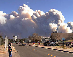
On April 25th, 1996, in mid-afternoon, the Dome wildland fire, started from an abandoned campfire in the Jemez Mountains, on the Santa Fe National Forest in the State of New Mexico, United States. The fire spread east onto Bandelier National Monument, lands administered by the National Park Service. The fire was named “Dome” after the lookout tower located 3 miles to the west of the point of ignition, on a mountain peak named St. Peters Dome.
Topography in the fire area is very rugged with deep canyons and high mountains. Elevations in the area range from about 7,000 feet to 8,400 feet. The main topographic feature is Capulin Canyon and the San Miguel Mountains. Major peaks in this area include St. Peters Dome and Boundary Peak. The Rio Grande River is located 4 miles to the east of the fire at 5,300 feet elevation. The city of Los Alamos is located about 6 miles to the north of where the fire was kindled.
The predominate vegetation in the fire area consisted of mixed conifer timber, with Pinus ponderosa (ponderosa pine), Pseudotsuga menziesii (Douglas fir) and Abies concolor (white fir) and scattered stands of Populis tremuloides (quaking aspen). Timbered areas were either open with an understory of grass and small shrubs or very dense with heavy ladder fuels and thickets of pole size trees. The lower elevations and drier sites are dominated by brush including juniper (various species), and Pinus edulis (pinyon pine).
The pure stands of ponderosa pine in the area are typical of National Forest Fire Lab (NFFL) fuel model 9, which is long leaf pine litter. Fire spread is typically in pine litter with occasional jackpots of heavy woody material which contribute to spotting and torching. The mixed conifer stands of pine and fir in the area are typical of NFFL fuel model 10, a timber over story with heavy downed woody fuels. Brush fuel types in the fire area consisted of mostly pinyon, juniper and oak with scattered grass understory, typical of NFFL fuel model 5. With low wind speeds fire spread is fairly slow in this fuel model. There was also a significant loading of downed logs on mesa tops from a 1950's wind event, that influenced fire behavior on the Dome Fire.
In April of 1996, northern New Mexico was in a moderate to severe drought as measured by the Palmer Drought Index. The Tower remote automated weather station (RAWS), located 6 miles to the east of the fire received scant rainfall in the months prior to the Dome Fire, with less than an inch of rain before April 25th. Both live fuel moistures and dead fuel moistures were extremely low, due to drought conditions. National Fire Danger Rating System (NFDRS) indices for the energy release component (ERC) for the Tower RAWS set records for much of March through April of 1996, based on historic weather observations from 1964 to 1996, with values well above the 90th percentile for much of that period.
When the initial attack crews arrived at the fire location at 3:00 PM on June 25th, the fire was 2 ½ acres in size. The Dome fire was active all night of the 25th into the morning the 26th, spreading mainly to the east into Capulin Canyon and along the main ridgeline that defines that San Miguel Mountains. During the evening of June 25th a Type II incident management team (team) was ordered, and they took control of the fire, the next morning, at 0600 hours. The team prepared an incident action plan (IAP) for April 26th, and a briefing was given to all staff early that morning. The IAP included a fire behavior forecast, prepared by a fire behavior analyst (FBAN) which articulated the possibility of extreme fire behavior but never predicted crown fire activity.
Fire weather forecasts for the Dome Fire were obtained from the National Weather Service (NWS) in Albuquerque, New Mexico. The fire weather forecast, issued at 8:35 am, for April 26th, indicated there was an upper level ridge of high pressure over New Mexico, with a mostly sunny and dry day expected. Temperatures in the mountains were expected to be in the mid 70's, winds north to northwest winds at 15 to 25 mph and the Haines Index a 3 or low. The air mass over the Dome fire on the morning of the 26th was dry but relatively stable and the Haines Index was calculated as a 3 which indicated very low potential for large fire growth. However this prediction did not represent actual conditions by mid day on the 26th, when the late afternoon balloon sounding indicating cooler air aloft associated with a passing disturbance spread over the fire area, which quickly destabilizing the air mass, increased the Haines Index to a 5. The Haines Index is a weather index developed by meteorologist Donald Haines in 1988 that measures the potential for rapid forest fire growth, based at stability and dryness of the atmosphere.
From the morning into early afternoon of the 26th, fire behavior was moderate with flame lengths generally less than 3 feet and low spread rates. At 1300 hours a weather observation was taken at the Dome lookout tower at 8400 feet, and the winds were very light and variable which seemed abnormal for the early afternoon hours. At approximately 1400 hours a spot fire was discovered, next to Forest Road 142, on top of the main ridge. The spot was a couple of acres in size and was burning in a open stand of mature ponderosa pine, mostly backing with flame lengths less than 2 feet. Fire crews in the area responded quickly and contained this fire.
The winds were in the fire crews favor most of the morning and early afternoon of April 26th because they were very light and blew out of southwest, which carried fire brands mostly into the burned area. Sometime in early afternoon the winds began shifting to a more west/northwest direction. At 1500 hours the northwesterly winds increased 3-4 miles per hour at the Tower weather station, which was also noticed by the firefighting crews on the scene. The relative humidity dropped to about 9% around the same time. The 20 foot winds for the two closest weather stations never exceeded 12 miles per hour, on that afternoon. The changing wind direction caused fire brands to be carried into unburned areas instead of into the black. Fire activity started to increase as flames pushed hard against road 142 and the main ridge line of the San Miguel Mountains.
The afternoon of April 26th, at around 3:30 pm, the Dome fire exploded into a major conflagration, and by late that evening had spread to 4,150 acres. Fire behavior was extreme and several crown fire events occurred, pushed by westerly winds with spread rates estimated at 1 to 2 miles per hour. The surface fire moved in conjunction with the crown fire. Three “20 person” fire crews and two engine crews moved into safety zones and escaped with one minor injury.
The fire perimeter map for the end of the day on the 26th shows an elliptical fire shape and indicates the fire spread generally from the northwest to the east and southeast towards St. Peters Dome. Topography appears to have played a minor part in affecting fire spread direction. An analysis of the fire behavior on April 26th, using the fire behavior and fuel prediction system called BehavePlus (Patricia L. Andrews), indicates a crown fire spread rate of ½ to 1 miles per hour. Surface fire spread rates prior to the fire blowup were approximately 500 feet per hour which jumped to 1000 feet per hour as the winds picked up and the atmosphere became more unstable.
The fuels, weather and topography changed very little from the 25th to the 26th. The weather was cooler and less windy on April 26th compared to April 25th and the NFDRS indices showed a decrease in the energy release component (55 decreasing to 51). The only major difference between the two days was the Haines Index. The Haines Index on April 25th was a 4 (low potential for large fire growth) and on April 26th was a 5 (moderate potential for large fire growth). Cooler air aloft associated with a passing disturbance spread over the fire area on the 26th, increasing the Haines Index to a 5, and quickly destabilized the air mass, but no significant drying occurred that afternoon. National Weather Service fire weather meteorologists, Kerry M. Jones and Bob Berkowitz, reviewed the data from that week and determined that the Haines Index was the most critical weather factor.
Based upon observations and an analysis of fire behavior, the Dome fire may have been "plume dominated" during the afternoon of April 26th. Ground observations and photos taken of the convection column appear to show a plume dominated fire for the first part of the crown fire run, then show the smoke column shearing off.
The next several days the Dome Fire was very active with periods of extreme fire behavior. Fire crews flanked the fire on the north and south sides burning out along road systems and trails, allowing the fire to move to the east where natural barriers and low fuel loading helped slow or stop the fire spread. The fire was finally contained at 16,468 acres.
Conclusions
Predicting wildland fire behavior is a challenging task in the best of circumstances. The FBAN often faces a tough job of gathering environmental variables, obtaining an accurate map of the fire perimeter, then selecting a fire behavior model that will provide accurate, relevant and timely results. Data can be erroneous, missing or outdated, plus there are limitations to the fire behavior and fire weather models. Fire danger indices were at record levels during the Dome Fire which added to the challenge of predicting the initiation of a crown fire event.
The tools available to predict transition to crown fire and associated spread rates were very limited, in 1996. That has changed in the last several years. Fire behavior software now can model the transition to crown fire and crown fire spread rates, with the critical inputs being crown base height and foliar moisture of the conifer trees. Even with improved fire modeling software there are still many challenges in predicting crown fire events. Accurate and timely fire weather and fire behavior observations, and gathering of fuels information is essential. The Haines Index is not an input in fire behavior models, but during large fires it needs to be carefully tracked and used with other tools and on-site observations to evaluate the potential for large fire growth.
During high fire danger periods, even subtle changes in environmental conditions can ignite extreme fire behavior, which is what happened on the Dome Fire. Changing weather conditions, such as frontal passages, wind direction, temperatures and humidity need to be carefully monitored. These changes may not be readily visible to the firefighter on the ground, making escape routes and safety zones, even more important. Hence the importance of fire crew supervisors having a good knowledge and training in fire behavior.
On large fires the importance of obtaining on-site fire weather forecasting from an incident meteorologist (IMET) is critical. The IMET can provide weather forecasts, and briefings tailored to the specific fire environment and be a ready source of information for the FBAN.
--GrizRich (talk) 04:00, 14 October 2011 (UTC)
A fire behavior analyst has to rely on their own personal judgment using an appropriate set of tools, when preparing a fire behavior prediction. The fire behavior prediction for any given day, is only a starting point, and needs to be reevaluated by fire line personnel throughout the day. Actual fire behavior and environmental conditions, have to be closely monitored on each division, and tactical fire operations adjusted as needed, to insure safety of personnel.
Acknowledgements
The author acknowledges the input and/or review and thoughtful comments provided by;
Kerry Jones, National Weather Service
Bob Berkowitz, National Weather Service (retired)
Matthew Tafoya, Crew Boss of the Blackmesa Fire Fighters
John Lissoway, Fire Management Officer, National Park Service (retired),