
Valley Hi, Ohio
Encyclopedia
Valley Hi is a village in Logan County
, Ohio
, United States
. The population was 244 at the 2000 census
. The village is located nearby U.S. Route 33
and is about an hour northwest of Columbus
.
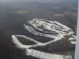
The village is located in an area with some of the steepest terrain in normally flat Western Ohio and serves as home to the Mad River Mountain
ski
area. In fact, most of the village is located on top of a steep ridge (mountain, by some standards) and is actually located above the ski area, with many of the slopes circling one side of the village. Valley Hi has a distinct "Alpine" flavor with many of the streets named for European mountain locations and homes decorated in a Swiss chalet
style.
According to the United States Census Bureau
, the village has a total area of 0.7 square miles (1.8 km²), all of it land.
of 2000, there were 244 people, 97 households, and 65 families residing in the village. The population density
was 370.4 people per square mile (142.7/km²). There were 113 housing units at an average density of 171.5 per square mile (66.1/km²). The racial makeup of the village was 97.95% White, 0.41% Native American, 0.41% Pacific Islander, and 1.23% from two or more races. Hispanic or Latino of any race were 0.82% of the population.
There were 97 households out of which 39.2% had children under the age of 18 living with them, 50.5% were married couples
living together, 10.3% had a female householder with no husband present, and 32.0% were non-families. 23.7% of all households were made up of individuals and 2.1% had someone living alone who was 65 years of age or older. The average household size was 2.52 and the average family size was 2.98.
In the village the population was spread out with 28.3% under the age of 18, 11.9% from 18 to 24, 37.3% from 25 to 44, 16.4% from 45 to 64, and 6.1% who were 65 years of age or older. The median age was 30 years. For every 100 females there were 106.8 males. For every 100 females age 18 and over, there were 118.8 males.
The median income for a household in the village was $43,125, and the median income for a family was $46,364. Males had a median income of $32,350 versus $26,250 for females. The per capita income
for the village was $17,077. About 3.7% of families and 4.7% of the population were below the poverty line, including 4.1% of those under the age of eighteen and none of those sixty five or over.
, which is accessed by an interchange
less than a mile from the village.
Logan County, Ohio
Logan County is a county in the state of Ohio, United States. As of the 2010 census, the population was 45,858. The county seat is Bellefontaine. The county is named for Benjamin Logan, who fought Native Americans in the area....
, Ohio
Ohio
Ohio is a Midwestern state in the United States. The 34th largest state by area in the U.S.,it is the 7th‑most populous with over 11.5 million residents, containing several major American cities and seven metropolitan areas with populations of 500,000 or more.The state's capital is Columbus...
, United States
United States
The United States of America is a federal constitutional republic comprising fifty states and a federal district...
. The population was 244 at the 2000 census
United States Census, 2000
The Twenty-second United States Census, known as Census 2000 and conducted by the Census Bureau, determined the resident population of the United States on April 1, 2000, to be 281,421,906, an increase of 13.2% over the 248,709,873 persons enumerated during the 1990 Census...
. The village is located nearby U.S. Route 33
U.S. Route 33
U.S. Route 33 is a United States federal highway that runs northwest-southeast for 709 miles from northern Indiana to Richmond, Virginia, passing through Ohio and West Virginia en route. Although most odd-numbered U.S...
and is about an hour northwest of Columbus
Columbus, Ohio
Columbus is the capital of and the largest city in the U.S. state of Ohio. The broader metropolitan area encompasses several counties and is the third largest in Ohio behind those of Cleveland and Cincinnati. Columbus is the third largest city in the American Midwest, and the fifteenth largest city...
.
The village is located in an area with some of the steepest terrain in normally flat Western Ohio and serves as home to the Mad River Mountain
Mad River Mountain
Mad River Mountain is a ski and snowboard resort in Valley Hi, Ohio, United States. The elevation of Mad River Mountain is with a vertical drop of , and it has a ski season that runs from December 1 through March 16...
ski
Skiing
Skiing is a recreational activity using skis as equipment for traveling over snow. Skis are used in conjunction with boots that connect to the ski with use of a binding....
area. In fact, most of the village is located on top of a steep ridge (mountain, by some standards) and is actually located above the ski area, with many of the slopes circling one side of the village. Valley Hi has a distinct "Alpine" flavor with many of the streets named for European mountain locations and homes decorated in a Swiss chalet
Chalet
A chalet , also called Swiss chalet, is a type of building or house, native to the Alpine region, made of wood, with a heavy, gently sloping roof with wide, well-supported eaves set at right angles to the front of the house.-Definition and origin:...
style.
Geography
Valley Hi is located at 40°18′45"N 83°40′46"W (40.312531, -83.679559).According to the United States Census Bureau
United States Census Bureau
The United States Census Bureau is the government agency that is responsible for the United States Census. It also gathers other national demographic and economic data...
, the village has a total area of 0.7 square miles (1.8 km²), all of it land.
Demographics
As of the censusCensus
A census is the procedure of systematically acquiring and recording information about the members of a given population. It is a regularly occurring and official count of a particular population. The term is used mostly in connection with national population and housing censuses; other common...
of 2000, there were 244 people, 97 households, and 65 families residing in the village. The population density
Population density
Population density is a measurement of population per unit area or unit volume. It is frequently applied to living organisms, and particularly to humans...
was 370.4 people per square mile (142.7/km²). There were 113 housing units at an average density of 171.5 per square mile (66.1/km²). The racial makeup of the village was 97.95% White, 0.41% Native American, 0.41% Pacific Islander, and 1.23% from two or more races. Hispanic or Latino of any race were 0.82% of the population.
There were 97 households out of which 39.2% had children under the age of 18 living with them, 50.5% were married couples
Marriage
Marriage is a social union or legal contract between people that creates kinship. It is an institution in which interpersonal relationships, usually intimate and sexual, are acknowledged in a variety of ways, depending on the culture or subculture in which it is found...
living together, 10.3% had a female householder with no husband present, and 32.0% were non-families. 23.7% of all households were made up of individuals and 2.1% had someone living alone who was 65 years of age or older. The average household size was 2.52 and the average family size was 2.98.
In the village the population was spread out with 28.3% under the age of 18, 11.9% from 18 to 24, 37.3% from 25 to 44, 16.4% from 45 to 64, and 6.1% who were 65 years of age or older. The median age was 30 years. For every 100 females there were 106.8 males. For every 100 females age 18 and over, there were 118.8 males.
The median income for a household in the village was $43,125, and the median income for a family was $46,364. Males had a median income of $32,350 versus $26,250 for females. The per capita income
Per capita income
Per capita income or income per person is a measure of mean income within an economic aggregate, such as a country or city. It is calculated by taking a measure of all sources of income in the aggregate and dividing it by the total population...
for the village was $17,077. About 3.7% of families and 4.7% of the population were below the poverty line, including 4.1% of those under the age of eighteen and none of those sixty five or over.
Transportation
Due to its location at the top of the ridgeline, Valley Hi contains only a few winding streets. Moreover, it is not as easily accessed as some nearby towns, as the only road into the village is County Road 291. The nearest highway is U.S. Route 33U.S. Route 33
U.S. Route 33 is a United States federal highway that runs northwest-southeast for 709 miles from northern Indiana to Richmond, Virginia, passing through Ohio and West Virginia en route. Although most odd-numbered U.S...
, which is accessed by an interchange
Interchange (road)
In the field of road transport, an interchange is a road junction that typically uses grade separation, and one or more ramps, to permit traffic on at least one highway to pass through the junction without directly crossing any other traffic stream. It differs from a standard intersection, at which...
less than a mile from the village.