
Llangelynnin
Encyclopedia
Llangelynnin is a former parish in the Conwy valley, in Conwy county borough, north Wales
. Today the name exists only in connection with the church, a school in the nearby village of Henryd
, and the nearby mountain ridge, Craig Celynnin.
Llangelynnin Church (Welsh: Eglwys Llangelynnin) is possibly one of the remotest churches in Wales (53.2458°N 3.8730°W), and is amongst the oldest; that at Llanrhychwyn
, further up the valley, is a little older. The church is dedicated to Saint Celynin, who lived in the 6th century and probably established the first religious settlement here. It lies at a height of just over 900 feet above the village of Henryd in the Conwy valley, in the shelter of Tal y Fan (610m), the hill to the south-west.
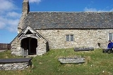
A small and simple building, it probably dates from the 12th century (although some sources cite the 13th century), and was probably pre-dated by an earlier church of timber, or wattle and daub
construction. Llangelynnin is also the name of the former parish, the primary school in nearby Henryd (Ysgol Llangelynnin). Celynnin's name is also carried by Craig Celynnin, a mountain ridge adjacient to the church.
, the prince who lived at Llys Helig before the sea inundated the land off the coast of Penmaenmawr
. It is said that Celynin was related to Rhun, son of Maelgwn Gwynedd, Prince of Gwynedd, who is known to have ruled in the 6th century, and that he was also a brother to Rhychwyn, the saint associated with Llanrhychwyn
church.
 Next to the church lie the remains of an ancient hut circle, and some stories romantically suggest that this was where St. Celynin himself lived. The church is overlooked from the north-east by the adjacent crags of Cerrig-y-ddinas, the site of an Iron Age
hill fort. These crags afford wide views down the Conwy valley to the sea, and up the valley as far as Dolgarrog
.
An old walled bridleway route leads east from the church, down through Parc Mawr, an area of woodland now owned by the Woodland Trust
, who are replacing the 1960s-planted conifers with native species. The path through the wood leads towards the valley bottom, and to the west a route leads towards Penmaenmawr
, past the Bronze Age
standing stones of Maen Penddu. To the south-west a path meets the important Neolithic
route and Roman Road
passing through Bwlch-y-Ddeufaen
, which connected the Conwy valley to the north coast near Llanfairfechan
, and places further westwards.
in its east (right) wall. Repairs to the porch roof were made using yew
wood, and therefore it is quite possible that these came from the churchyard, which at one time contained trees. The door hinges and threshold date from the 14th century, although the door itself is more recent.
The nave
is the oldest part of the church, dating from the 12th century, and the present chancel
was added later, probably in the 14th century. Originally the nave would not have been paved, as it is today, and indeed, the rear of the north chapel remains unpaved even today. The roof contains dark oak rafters.
The north transept was added in the 15th century and was known as Capel Meibion, the "men's chapel". The window at the back of the chapel was a more recent addition.
Opposite the north transept, a south transept was also added, probably in the 16th century. This was called Capel Eirianws (meaning "Plum Orchard", the name of a local farm), whose owner possibly had it built. This chapel was demolished in the 19th century, but some remains are still visible from outside.
The present east window dates from the 15th century, and replaced a smaller 14th century window.
Since demolition of the south chapel (and the gallery) in the 19th century, the church has changed little.
, the Lord's Prayer
and the Ten Commandments
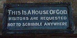
, in Welsh. The inscription "Fear God and honour the King", together with scrollwork, can clearly be seen today, as can a skull and cross-bones! The Welsh version of the Lord's Prayer, on the sill, is hardly visible, after vandalism.
The remains of the rood screen
in front of the more recent lectern
date from the 14th century, and would have separated the nave from the chancel. The church once had a rood loft and gallery, and the remains of these can be seen in on the nave walls, and from the beam at the back of the church. The gallery was demolished in the 19th century.
The reader's desk possibly dates from the 16th century, although the door is more recent.
The wooden benches in the nave date from the 18th century, although at least one bench in the church dates from 1629 http://www.google.com/search?q=cache:49Foo0K7-fQJ:www.conwy.gov.uk/upload/public/attachments/268/EHDRhaglen2006THISONE1NEWCYM.pdf+%22Eglwys+Llangelynnin%22&hl=cy&ct=clnk&cd=7). One bench (at the front of the north chapel) still bears the initials R.O.B., this being the Reverend Owen Bulkeley, a former rector, who died in 1737. A church terrier of 1742 records a particular bench which was used by women only.
Just inside the church, on the wall, is a holy water stoup, used until the 19th century for making the sign of the Cross. At the back of the church is an octagonal font, which probably dates from the 13th or 14th century. The bell has no inscription and its date is therefore unknown.
On the wall in the nave is a bier, used to carry the dead to the churchyard.
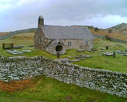
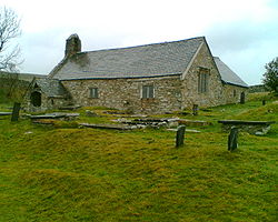
 The churchyard is walled, with an arched entrance in the eastern wall. Today it is almost devoid of tree growth, but this was not always so.
The churchyard contains a fair number of gravestones, dating back to the 14th century. These graves were not dug in any uniform layout. Indeed, the rock outcrops to such a degree that finding space for graves has been a problem over the centuries.
itself almost certainly predates the church.
Beyond the south-east corner of the churchyard there was once an old inn, demolished in the 19th century.
. Whereas the old church reflects a simple mediaeval design, the new church was designed by Thomas Jones of Chester
in a much grander, lofty late Georgian
style. Unusually, the tower has a square lower storey surmounted by an octagonal embattled upper stage. The original plans of 1839 still exist http://www.churchplansonline.org/show_full_image.asp?resource_id=02549b.tif.
A plaque in the doorway refers to the "re-erection" of the building, implying perhaps that there was an earlier building on this site, but there is no evidence to this effect, and no gravestones pre-date 1839. The Religious Census of 1851 refers to it being erected in "1839 or 1840", but makes no reference to the Old Church.
This "new" church also eventually closed (in the 1980s), but the font from the church is now displayed by the altar in Llangelynnin old church. Llangelynnin "new" church is now the studio of David Chapman, a sculptor and artist.
 Despite its remoteness, the church is well signposted from Henryd
, which lies off the B5106 south of Conwy
. The single track road is metalled up to the small car park below the church. The church is not named on the Ordnance Survey
map, but lies at reference SH751737.
The church is open to visitors at most times. Only occasionally are services held in the church, in the summer and on special occasions.
Wales
Wales is a country that is part of the United Kingdom and the island of Great Britain, bordered by England to its east and the Atlantic Ocean and Irish Sea to its west. It has a population of three million, and a total area of 20,779 km²...
. Today the name exists only in connection with the church, a school in the nearby village of Henryd
Henryd
Henryd is a small village on the western slopes of the Conwy valley in Conwy county borough, north Wales. It lies about two miles south of Conwy, off the B5106 road.The river Henryd, a tributary of the river Conwy, flows through the village...
, and the nearby mountain ridge, Craig Celynnin.
Llangelynnin Church (Welsh: Eglwys Llangelynnin) is possibly one of the remotest churches in Wales (53.2458°N 3.8730°W), and is amongst the oldest; that at Llanrhychwyn
Llanrhychwyn
LlanrhychwynConwyLlanrhychwyn is a hamlet in Conwy county borough, Wales. It lies in the Conwy valley in North Wales, less than a mile south of Trefriw, and a mile north-west of Llanrwst...
, further up the valley, is a little older. The church is dedicated to Saint Celynin, who lived in the 6th century and probably established the first religious settlement here. It lies at a height of just over 900 feet above the village of Henryd in the Conwy valley, in the shelter of Tal y Fan (610m), the hill to the south-west.
A small and simple building, it probably dates from the 12th century (although some sources cite the 13th century), and was probably pre-dated by an earlier church of timber, or wattle and daub
Wattle and daub
Wattle and daub is a composite building material used for making walls, in which a woven lattice of wooden strips called wattle is daubed with a sticky material usually made of some combination of wet soil, clay, sand, animal dung and straw...
construction. Llangelynnin is also the name of the former parish, the primary school in nearby Henryd (Ysgol Llangelynnin). Celynnin's name is also carried by Craig Celynnin, a mountain ridge adjacient to the church.
St. Celynin
Celynin lived in the 6th century, and according to tradition was one of the sons of Helig ap GlanawgHelig ap Glanawg
Helig ap Glanawg was a 6th-century prince who lived in North Wales.It is said that the river Conwy once reached the sea by the Great Orme, Llandudno, and to the west lay the great cantref of Gwaelod which stretched all the way to Puffin Island, off Anglesey.Helig ap Glanawg lived here, but in the...
, the prince who lived at Llys Helig before the sea inundated the land off the coast of Penmaenmawr
Penmaenmawr
PenmaenmawrConwyPenmaenmawr is a town in the parish of Dwygyfylchi, in Conwy County Borough, Wales. The population was 3857 in 2001. It is a quarrying town, though the latter is no longer a major employer, on the North Wales coast between Conwy and Llanfairfechan.The town was bypassed by the A55...
. It is said that Celynin was related to Rhun, son of Maelgwn Gwynedd, Prince of Gwynedd, who is known to have ruled in the 6th century, and that he was also a brother to Rhychwyn, the saint associated with Llanrhychwyn
Llanrhychwyn
LlanrhychwynConwyLlanrhychwyn is a hamlet in Conwy county borough, Wales. It lies in the Conwy valley in North Wales, less than a mile south of Trefriw, and a mile north-west of Llanrwst...
church.
Location
Iron Age
The Iron Age is the archaeological period generally occurring after the Bronze Age, marked by the prevalent use of iron. The early period of the age is characterized by the widespread use of iron or steel. The adoption of such material coincided with other changes in society, including differing...
hill fort. These crags afford wide views down the Conwy valley to the sea, and up the valley as far as Dolgarrog
Dolgarrog
Dolgarrog is a small village in the Conwy County Borough in North Wales situated between Llanrwst and Conwy, very close to the Conwy River. The village is well known for its industrial history since the 18th century and the Eigiau dam disaster, which occurred in 1925...
.
Pathways
Many old paths lie in the area, and these routes would have been established at a time when the hills were considerably more wooded.An old walled bridleway route leads east from the church, down through Parc Mawr, an area of woodland now owned by the Woodland Trust
Woodland Trust
The Woodland Trust is a conservation charity in the United Kingdom concerned with the protection and sympathetic management of native woodland heritage.-History:...
, who are replacing the 1960s-planted conifers with native species. The path through the wood leads towards the valley bottom, and to the west a route leads towards Penmaenmawr
Penmaenmawr
PenmaenmawrConwyPenmaenmawr is a town in the parish of Dwygyfylchi, in Conwy County Borough, Wales. The population was 3857 in 2001. It is a quarrying town, though the latter is no longer a major employer, on the North Wales coast between Conwy and Llanfairfechan.The town was bypassed by the A55...
, past the Bronze Age
Bronze Age
The Bronze Age is a period characterized by the use of copper and its alloy bronze as the chief hard materials in the manufacture of some implements and weapons. Chronologically, it stands between the Stone Age and Iron Age...
standing stones of Maen Penddu. To the south-west a path meets the important Neolithic
Neolithic
The Neolithic Age, Era, or Period, or New Stone Age, was a period in the development of human technology, beginning about 9500 BC in some parts of the Middle East, and later in other parts of the world. It is traditionally considered as the last part of the Stone Age...
route and Roman Road
Roman road
The Roman roads were a vital part of the development of the Roman state, from about 500 BC through the expansion during the Roman Republic and the Roman Empire. Roman roads enabled the Romans to move armies and trade goods and to communicate. The Roman road system spanned more than 400,000 km...
passing through Bwlch-y-Ddeufaen
Bwlch-y-Ddeufaen
Bwlch-y-Ddeufaen is a mountain pass in Conwy county borough, north Wales, traversable only on foot or horseback, following the former Roman road from Caerhun to Caernarfon...
, which connected the Conwy valley to the north coast near Llanfairfechan
Llanfairfechan
Llanfairfechan is a town and community in the Conwy County Borough, Wales. It lies on the coast of north Wales on the route of the A55 road, between Penmaenmawr and Bangor. It previously was in Gwynedd and prior to that was in Caernarfonshire. For ceremonial and electoral boundary purposes it was...
, and places further westwards.
The church building
The porch was added in the 15th century, and features an unusual "squint window"Hagioscope
A hagioscope or squint, in architecture, is an opening through the wall of a church in an oblique direction, to enable the worshippers in the transepts or other parts of the church, from which the altar was not visible, to see the elevation of the host.Hagioscopes were also sometimes known as...
in its east (right) wall. Repairs to the porch roof were made using yew
Taxus
Taxus is a genus of yews, small coniferous trees or shrubs in the yew family Taxaceae. They are relatively slow-growing and can be very long-lived, and reach heights of 1-40 m, with trunk diameters of up to 4 m...
wood, and therefore it is quite possible that these came from the churchyard, which at one time contained trees. The door hinges and threshold date from the 14th century, although the door itself is more recent.
The nave
Nave
In Romanesque and Gothic Christian abbey, cathedral basilica and church architecture, the nave is the central approach to the high altar, the main body of the church. "Nave" was probably suggested by the keel shape of its vaulting...
is the oldest part of the church, dating from the 12th century, and the present chancel
Chancel
In church architecture, the chancel is the space around the altar in the sanctuary at the liturgical east end of a traditional Christian church building...
was added later, probably in the 14th century. Originally the nave would not have been paved, as it is today, and indeed, the rear of the north chapel remains unpaved even today. The roof contains dark oak rafters.
The north transept was added in the 15th century and was known as Capel Meibion, the "men's chapel". The window at the back of the chapel was a more recent addition.
Opposite the north transept, a south transept was also added, probably in the 16th century. This was called Capel Eirianws (meaning "Plum Orchard", the name of a local farm), whose owner possibly had it built. This chapel was demolished in the 19th century, but some remains are still visible from outside.
The present east window dates from the 15th century, and replaced a smaller 14th century window.
Since demolition of the south chapel (and the gallery) in the 19th century, the church has changed little.
Artifacts
The twist-turned altar rails and the altar screen date from the 17th century. The removal of a pulpit to the left of the altar revealed inscriptions on the east wall, and further removal of whitewash revealed the CreedCreed
A creed is a statement of belief—usually a statement of faith that describes the beliefs shared by a religious community—and is often recited as part of a religious service. When the statement of faith is longer and polemical, as well as didactic, it is not called a creed but a Confession of faith...
, the Lord's Prayer
Lord's Prayer
The Lord's Prayer is a central prayer in Christianity. In the New Testament of the Christian Bible, it appears in two forms: in the Gospel of Matthew as part of the discourse on ostentation in the Sermon on the Mount, and in the Gospel of Luke, which records Jesus being approached by "one of his...
and the Ten Commandments
Ten Commandments
The Ten Commandments, also known as the Decalogue , are a set of biblical principles relating to ethics and worship, which play a fundamental role in Judaism and most forms of Christianity. They include instructions to worship only God and to keep the Sabbath, and prohibitions against idolatry,...
, in Welsh. The inscription "Fear God and honour the King", together with scrollwork, can clearly be seen today, as can a skull and cross-bones! The Welsh version of the Lord's Prayer, on the sill, is hardly visible, after vandalism.
The remains of the rood screen
Rood screen
The rood screen is a common feature in late medieval church architecture. It is typically an ornate partition between the chancel and nave, of more or less open tracery constructed of wood, stone, or wrought iron...
in front of the more recent lectern
Lectern
A lectern is a reading desk with a slanted top, usually placed on a stand or affixed to some other form of support, on which documents or books are placed as support for reading aloud, as in a scripture reading, lecture, or sermon...
date from the 14th century, and would have separated the nave from the chancel. The church once had a rood loft and gallery, and the remains of these can be seen in on the nave walls, and from the beam at the back of the church. The gallery was demolished in the 19th century.
The reader's desk possibly dates from the 16th century, although the door is more recent.
The wooden benches in the nave date from the 18th century, although at least one bench in the church dates from 1629 http://www.google.com/search?q=cache:49Foo0K7-fQJ:www.conwy.gov.uk/upload/public/attachments/268/EHDRhaglen2006THISONE1NEWCYM.pdf+%22Eglwys+Llangelynnin%22&hl=cy&ct=clnk&cd=7). One bench (at the front of the north chapel) still bears the initials R.O.B., this being the Reverend Owen Bulkeley, a former rector, who died in 1737. A church terrier of 1742 records a particular bench which was used by women only.
Just inside the church, on the wall, is a holy water stoup, used until the 19th century for making the sign of the Cross. At the back of the church is an octagonal font, which probably dates from the 13th or 14th century. The bell has no inscription and its date is therefore unknown.
On the wall in the nave is a bier, used to carry the dead to the churchyard.
Renovation
Major renovation of the church was carried out in 1932 and in 1987. This later renovation work was carried out under the guidance of Gerald Speechley, and a plaque in the church records this. He died three years later.The churchyard
The churchyard contains a fair number of gravestones, dating back to the 14th century. These graves were not dug in any uniform layout. Indeed, the rock outcrops to such a degree that finding space for graves has been a problem over the centuries.
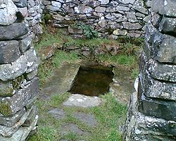
The Holy Well
In the south-eastern corner of the churchyard is a well, Ffynnon Gelynin (sometimes known as "The Holy Well of St. Celynin"), a small walled rectangular pool, which was renowned for its power to cure sick children. One old story relates that parents would throw items of their sick child's clothing into the water. If the clothes floated their child would live. If they sank the child was destined to die of the illness. The well was once roofed over but this structure no longer exists. The walls round the well, and probably the benches too, were later additions made when the churchyard was restored. The presence of surface water at this elevation was probably the reason for its designation as a site for early settlement, and the holy wellHoly well
A holy well, or sacred spring, is a small body of water emerging from underground and revered either in a Pagan or Christian context, often both. Holy wells were frequently pagan sacred sites that later became Christianized. The term 'holy well' is commonly employed to refer to any water source of...
itself almost certainly predates the church.
Outside the churchyard
Outside the churchyard itself, close to the well, are the remains of a round building. A church terrier of 1742 refers to this, and to its use as a stable.Beyond the south-east corner of the churchyard there was once an old inn, demolished in the 19th century.
The "new" church
Llangelynnin church was used regularly until 1840, when it closed following depopulation of the area. A new church was consequently built, carrying the same name, nearer the centres of population. This church is situated close to the 15th century Groes Inn (on the B5106 road), on the road which runs from the inn to the village of RowenRowen, Conwy
Rowen is a small village on the western slopes of the Conwy valley in Conwy county borough, north Wales. It lies off the B5106 road, between Dolgarrog and Conwy....
. Whereas the old church reflects a simple mediaeval design, the new church was designed by Thomas Jones of Chester
Chester
Chester is a city in Cheshire, England. Lying on the River Dee, close to the border with Wales, it is home to 77,040 inhabitants, and is the largest and most populous settlement of the wider unitary authority area of Cheshire West and Chester, which had a population of 328,100 according to the...
in a much grander, lofty late Georgian
Georgian architecture
Georgian architecture is the name given in most English-speaking countries to the set of architectural styles current between 1720 and 1840. It is eponymous for the first four British monarchs of the House of Hanover—George I of Great Britain, George II of Great Britain, George III of the United...
style. Unusually, the tower has a square lower storey surmounted by an octagonal embattled upper stage. The original plans of 1839 still exist http://www.churchplansonline.org/show_full_image.asp?resource_id=02549b.tif.
A plaque in the doorway refers to the "re-erection" of the building, implying perhaps that there was an earlier building on this site, but there is no evidence to this effect, and no gravestones pre-date 1839. The Religious Census of 1851 refers to it being erected in "1839 or 1840", but makes no reference to the Old Church.
This "new" church also eventually closed (in the 1980s), but the font from the church is now displayed by the altar in Llangelynnin old church. Llangelynnin "new" church is now the studio of David Chapman, a sculptor and artist.
Access to the church
Henryd
Henryd is a small village on the western slopes of the Conwy valley in Conwy county borough, north Wales. It lies about two miles south of Conwy, off the B5106 road.The river Henryd, a tributary of the river Conwy, flows through the village...
, which lies off the B5106 south of Conwy
Conwy
Conwy is a walled market town and community in Conwy County Borough on the north coast of Wales. The town, which faces Deganwy across the River Conwy, formerly lay in Gwynedd and prior to that in Caernarfonshire. Conwy has a population of 14,208...
. The single track road is metalled up to the small car park below the church. The church is not named on the Ordnance Survey
Ordnance Survey
Ordnance Survey , an executive agency and non-ministerial government department of the Government of the United Kingdom, is the national mapping agency for Great Britain, producing maps of Great Britain , and one of the world's largest producers of maps.The name reflects its creation together with...
map, but lies at reference SH751737.
The church is open to visitors at most times. Only occasionally are services held in the church, in the summer and on special occasions.
Llangelynnin - The wider parish
The following extract comes from A Topographical Dictionary of Wales (1849) by Samuel Lewis :
LLANGELYNIN (LLAN-GELYNIN), a parish, in the union of Conway, hundred of LlêchWedd-Isâv, county of Carnarvon, North Wales, 3 miles (S. by W.) from Conway; containing 270 inhabitants. This parish, which derives its name from the dedication of its church to St. Celynin, who flourished towards the close of the sixth century, is situated at the north-eastern extremity of the county, bordering upon Denbighshire. A memorable battle was fought at Cymryd, in or near the parish, in the year 880, between the forces of Anarawd, Prince of North Wales, and those of Edred, Earl of Mercia, who attempted the conquest of the country. In this conflict Anarawd was completely victorious; he drove the Mercians from the field of battle, and continued to pursue them until they were finally expelled from the principality: the victory was called Dial Rhodri, or "Roderic's revenge," as Anarawd thus fully avenged the slaughter of his father Roderic in a descent of the Saxons upon Anglesey. The village, which is small, is beautifully situated in a fertile vale under the mountain called Tàl-y-Van. The surface of the parish is mountainous, the lands partially inclosed and cultivated, the soil various, and the surrounding scenery marked with features rather of boldness than of beauty. The living is a discharged rectory, rated in the king's books at £7; patron, the Bishop of Bangor. The incumbent's tithes have been commuted for a rent-charge of £250, and the glebe comprises five acres: a rent-charge of £5 is paid to the parish-clerk. The church is a small ancient edifice, in a state of considerable dilapidation. There are places of worship for Independents and Wesleyan Methodists; a day school in connexion with the Church, and a Sunday school belonging to the Independents. The Rev. Launcelot Bulkeley, in 1718, bequeathed £60, the interest to be paid to four widows, who are appointed at a vestry, and regularly receive the donation.