

Llanarmon-yn-Ial
Encyclopedia
Llanarmon-yn-Iâl is a village
, and local government community
, in Denbighshire
, Wales
, lying in limestone
country in the valley
of the River Alyn
.
of Mold
, at approximate Ordnance Survey
map grid reference
.
The boundaries of Llanarmon-yn-Iâl community include, as well as the main village, the villages of Eryrys
and Graianrhyd
, along with a number of small hamlets and large areas of farmland. The community lies mostly within the boundaries of the Clwydian Range
Area of Outstanding Natural Beauty
.
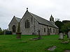
of Iâl (Yale)—the "fertile hill country"—grew up around a religious community dedicated to St. Germanus of Auxerre
(St. Garmon in the Welsh language
). Pilgrims travelling to St Garmon's shrine, which contained an image of the saint reputed to have miraculous properties, probably financed the construction of the impressive church of St. Garmon
, dating from the 13th century.
 Near to the village, the lords of Iâl had constructed an earth-and-timber motte
, Tomen-y-faerdre, during the 11th century, which seems to have acted as an administrative centre. King John of England rebuilt the castle in 1212 for his campaign against Llywelyn ap Iorwerth. Just to the east of the village, close to the river, is a cave
containing signs of Neolithic
human habitation.
Llanarmon was located on several drovers' roads and owed much of its prosperity to the cattle which passed through on their way from Anglesey
to the markets of England. In the nineteenth century it was one of the few places in north Wales where wheat
was grown, through heavy treatment of the fields with lime, which also helped to create lush pasture for the drovers' cattle. The local limestone quarries provided employment after the droving trade died out towards the end of the 19th century.
It was the birthplace of the Welsh folklorist and poet Robert Bryan (1858-1920).
, the last of the many drovers' inns that were once found in the village. Llanarmon is 2 miles from the A494
, a main north–south trunk route, and 3 miles from the A525
and the A5104 roads.
The village is approximately 1.5 miles east of the Offa's Dyke National Trail
. The picturesque nature of the village, and the natural beauty of its surroundings, combined with proximity to major routes, make it a popular destination for walkers
and other outdoor pursuits enthusiasts.
Village
A village is a clustered human settlement or community, larger than a hamlet with the population ranging from a few hundred to a few thousand , Though often located in rural areas, the term urban village is also applied to certain urban neighbourhoods, such as the West Village in Manhattan, New...
, and local government community
Community (Wales)
A community is a division of land in Wales that forms the lowest-tier of local government in Wales. Welsh communities are analogous to civil parishes in England....
, in Denbighshire
Denbighshire
Denbighshire is a county in north-east Wales. It is named after the historic county of Denbighshire, but has substantially different borders. Denbighshire has the distinction of being the oldest inhabited part of Wales. Pontnewydd Palaeolithic site has remains of Neanderthals from 225,000 years...
, Wales
Wales
Wales is a country that is part of the United Kingdom and the island of Great Britain, bordered by England to its east and the Atlantic Ocean and Irish Sea to its west. It has a population of three million, and a total area of 20,779 km²...
, lying in limestone
Limestone
Limestone is a sedimentary rock composed largely of the minerals calcite and aragonite, which are different crystal forms of calcium carbonate . Many limestones are composed from skeletal fragments of marine organisms such as coral or foraminifera....
country in the valley
Valley
In geology, a valley or dale is a depression with predominant extent in one direction. A very deep river valley may be called a canyon or gorge.The terms U-shaped and V-shaped are descriptive terms of geography to characterize the form of valleys...
of the River Alyn
River Alyn
The River Alyn is a tributary of the River Dee. The River Alyn rises at the southern end of the Clwydian hills and the Alyn Valley forms part of the Clwydian Range Area of Outstanding Natural Beauty...
.
Location
The village sits on the B5431 road, near the junction with the B5430, six miles south of the market townMarket town
Market town or market right is a legal term, originating in the medieval period, for a European settlement that has the right to host markets, distinguishing it from a village and city...
of Mold
Mold, Flintshire
Mold is a town in Flintshire, North Wales, on the River Alyn. It is the administrative seat of Flintshire County Council, and was also the county town of Clwyd from 1974 to 1996...
, at approximate Ordnance Survey
Ordnance Survey
Ordnance Survey , an executive agency and non-ministerial government department of the Government of the United Kingdom, is the national mapping agency for Great Britain, producing maps of Great Britain , and one of the world's largest producers of maps.The name reflects its creation together with...
map grid reference
Grid reference
Grid references define locations on maps using Cartesian coordinates. Grid lines on maps define the coordinate system, and are numbered to provide a unique reference to features....
.
The boundaries of Llanarmon-yn-Iâl community include, as well as the main village, the villages of Eryrys
Eryrys
Eryrys is a village in Denbighshire, Wales, located at approximate grid reference SJ203578, five miles south of Mold. The village is built on the limestone formation of Bryn Alyn and many limestone outcrops can be seen close by...
and Graianrhyd
Graianrhyd
Graianrhyd, also spelt Graeanrhyd, is a small, scattered village in the community of Llanarmon-yn-Ial, Denbighshire, Wales, lying in hilly limestone country around to the east of Lanarmon-yn-Ial village, and just to the south of Eryrys....
, along with a number of small hamlets and large areas of farmland. The community lies mostly within the boundaries of the Clwydian Range
Clwydian Range
The Clwydian Range is a series of hills and mountains in north east Wales that runs from Llandegla in the south to Prestatyn in the north, with the highest point being the popular Moel Famau...
Area of Outstanding Natural Beauty
Area of Outstanding Natural Beauty
An Area of Outstanding Natural Beauty is an area of countryside considered to have significant landscape value in England, Wales or Northern Ireland, that has been specially designated by the Countryside Agency on behalf of the United Kingdom government; the Countryside Council for Wales on...
.
History
The village, considered the capital of the commoteCommote
A commote , sometimes spelt in older documents as cymwd, was a secular division of land in Medieval Wales. The word derives from the prefix cym- and the noun bod...
of Iâl (Yale)—the "fertile hill country"—grew up around a religious community dedicated to St. Germanus of Auxerre
Auxerre
Auxerre is a commune in the Bourgogne region in north-central France, between Paris and Dijon. It is the capital of the Yonne department.Auxerre's population today is about 45,000...
(St. Garmon in the Welsh language
Welsh language
Welsh is a member of the Brythonic branch of the Celtic languages spoken natively in Wales, by some along the Welsh border in England, and in Y Wladfa...
). Pilgrims travelling to St Garmon's shrine, which contained an image of the saint reputed to have miraculous properties, probably financed the construction of the impressive church of St. Garmon
St Garmon's Church, Llanarmon-yn-Iâl
St Garmon's Church, Llanarmon-yn-Iâl, is in the centre of the village of Llanarmon-yn-Iâl, Denbighshire, Wales. It is an active Anglican church in the diocese of St Asaph, the archdeaconry of St Asaph and the deanery of Dyffryn Clwyd. The church is a Grade I listed building.-History:The church...
, dating from the 13th century.
Motte
Motte may be:*Motte-and-bailey, a type of construction used in castles*Isaac Motte, an 18th century American statesman*La Motte , various places with this name-See also:* Mote * Mott...
, Tomen-y-faerdre, during the 11th century, which seems to have acted as an administrative centre. King John of England rebuilt the castle in 1212 for his campaign against Llywelyn ap Iorwerth. Just to the east of the village, close to the river, is a cave
Cave
A cave or cavern is a natural underground space large enough for a human to enter. The term applies to natural cavities some part of which is in total darkness. The word cave also includes smaller spaces like rock shelters, sea caves, and grottos.Speleology is the science of exploration and study...
containing signs of Neolithic
Neolithic
The Neolithic Age, Era, or Period, or New Stone Age, was a period in the development of human technology, beginning about 9500 BC in some parts of the Middle East, and later in other parts of the world. It is traditionally considered as the last part of the Stone Age...
human habitation.
Llanarmon was located on several drovers' roads and owed much of its prosperity to the cattle which passed through on their way from Anglesey
Anglesey
Anglesey , also known by its Welsh name Ynys Môn , is an island and, as Isle of Anglesey, a county off the north west coast of Wales...
to the markets of England. In the nineteenth century it was one of the few places in north Wales where wheat
Wheat
Wheat is a cereal grain, originally from the Levant region of the Near East, but now cultivated worldwide. In 2007 world production of wheat was 607 million tons, making it the third most-produced cereal after maize and rice...
was grown, through heavy treatment of the fields with lime, which also helped to create lush pasture for the drovers' cattle. The local limestone quarries provided employment after the droving trade died out towards the end of the 19th century.
It was the birthplace of the Welsh folklorist and poet Robert Bryan (1858-1920).
Amenities
In the centre of the village can be found a small, traditional village shop and the Raven Inn public housePublic house
A public house, informally known as a pub, is a drinking establishment fundamental to the culture of Britain, Ireland, Australia and New Zealand. There are approximately 53,500 public houses in the United Kingdom. This number has been declining every year, so that nearly half of the smaller...
, the last of the many drovers' inns that were once found in the village. Llanarmon is 2 miles from the A494
A494 road
The A494 is an important trunk road in Wales. The road runs between "Drome Corner" at the intersection of the A548 and A550 by RAF Sealand, Queensferry and the A470 at Dolgellau, Gwynedd.-Beginnings:...
, a main north–south trunk route, and 3 miles from the A525
A525 road
The A525 is major route from Rhyl in North Wales to Newcastle-under-Lyme in England. On the way, it passes near to Denbigh, through Ruthin, through Wrexham and near Whitchurch.It is dual carriageway just south of Rhyl...
and the A5104 roads.
The village is approximately 1.5 miles east of the Offa's Dyke National Trail
Offa's Dyke Path
Offa's Dyke Path is a long distance footpath along the Welsh-English border. Opened in 1971, it is one of Britain's premier National Trails and draws walkers from throughout the world...
. The picturesque nature of the village, and the natural beauty of its surroundings, combined with proximity to major routes, make it a popular destination for walkers
Hillwalking
In the British Isles, the terms hillwalking or fellwalking are commonly used to describe the recreational outdoor activity of walking on hills and mountains, often with the intention of visiting their summits...
and other outdoor pursuits enthusiasts.