
List of unused highways in Oregon
Encyclopedia
An unused highway may reference a highway
or highway ramp that was partially or fully constructed but was unused or later closed. An unused ramp can be referred to as a stub ramp, stub street, stub-out, or simply stub. The following is a list:
Portland
Eugene
Highway
A highway is any public road. In American English, the term is common and almost always designates major roads. In British English, the term designates any road open to the public. Any interconnected set of highways can be variously referred to as a "highway system", a "highway network", or a...
or highway ramp that was partially or fully constructed but was unused or later closed. An unused ramp can be referred to as a stub ramp, stub street, stub-out, or simply stub. The following is a list:
PortlandPortland, OregonPortland is a city located in the Pacific Northwest, near the confluence of the Willamette and Columbia rivers in the U.S. state of Oregon. As of the 2010 Census, it had a population of 583,776, making it the 29th most populous city in the United States...
- Just before the northeast end of the Marquam Bridge are two stubs for the cancelled Mt. Hood FreewayMt. Hood FreewayThe Mount Hood Freeway is a partially completed but never to be finished freeway alignment of U.S. Route 26 and Interstate 80N , which would have run through southeast Portland, Oregon...
. Additional ramp stubs to this cancelled freeway were removed when Interstate 5 (which runs on the Marquam Bridge) was widened, but are visible here http://www.oregon.gov/ODOT/CS/SSB/history_center_bridges.shtml#Marquam_Bridge. http://local.live.com/default.aspx?v=2&cp=45.512441~-122.667404&style=h&lvl=18&tilt=-90&dir=0&alt=-1000&scene=5573469&encType=1
- On the Grand Avenue Viaduct (Oregon Route 99E) is a ramp stub that was to connect to the Mt. Hood Freeway
 Mt. Hood FreewayThe Mount Hood Freeway is a partially completed but never to be finished freeway alignment of U.S. Route 26 and Interstate 80N , which would have run through southeast Portland, Oregon...
. Viewable here. A construction project is underway to replace this viaduct; this project will likely involve removal of any ramp stubs.
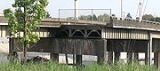
- The western end of the Hawthorne BridgeHawthorne BridgeThe Hawthorne Bridge is a truss bridge with a vertical lift that spans the Willamette River in Portland, Oregon, joining Hawthorne Boulevard and Madison Street. It is the oldest vertical-lift bridge in operation in the United States and the oldest highway bridge in Portland...
used to connect to the Harbor DriveHarbor DriveHarbor Drive is the name of a street in Portland, Oregon, which was formerly a freeway that carried U.S. Route 99W along the western shore of the Willamette River in the downtown area...
freeway, which has been torn down. A former cloverleafCloverleaf interchangeA cloverleaf interchange is a two-level interchange in which left turns, reverse direction in left-driving regions, are handled by ramp roads...
ramp in the northeast quadrant (seen in operation here) is now a stub ramp. Also visible is another ramp connecting the bridge to Naito Parkway and is now used as a pedestrian and bike path connecting the bridge to Tom McCall Waterfront ParkTom McCall Waterfront ParkGovernor Tom McCall Waterfront Park is a park located on the west bank of the Willamette River in downtown Portland, Oregon. It is , comprising 16 tax lots owned by the City of Portland....
. http://local.live.com/default.aspx?v=2&cp=45.514246~-122.674327&style=a&lvl=18&scene=3660935
- The Front Avenue overpass over Interstate 405Interstate 405 (Oregon)Interstate 405 is a short Interstate Highway in Portland, Oregon. It forms a loop from Interstate 5 that travels through downtown Portland west of the Willamette River.-Route description:...
is wider than it needs to be. Back when U.S. Route 26 was routed north of its current alignment, it was signed on this bridge until 1957. It was here that ramps allowed access to Harbor DriveHarbor DriveHarbor Drive is the name of a street in Portland, Oregon, which was formerly a freeway that carried U.S. Route 99W along the western shore of the Willamette River in the downtown area...
. http://local.live.com/default.aspx?v=2&cp=45.505867~-122.677771&style=a&lvl=18&scene=3660935
- On the west end of the Steel BridgeSteel BridgeThe Steel Bridge is a through truss, double lift bridge across the Willamette River in Portland, Oregon, United States. Its lower deck carries railroad and bicycle/pedestrian traffic, while the upper deck carries road traffic and light rail , making the bridge one of the most multimodal in the world...
was a ramp that connected southbound Oregon Route 99W traffic from the bridge to NW 1st Avenue. When Metropolitan Area Express (MAX) Light Rail was added to the bridge between 1984 and 1986, this ramp was closed to traffic and used exclusively for both directions of MAX trains. The ramp as a road is shown on this map. One can also see the rail lines on the bridge here http://local.live.com/default.aspx?v=2&cp=45.525744~-122.671687&style=a&lvl=18&scene=3660935
- On the ramp from Interstate 5Interstate 5 in OregonIn the U.S. state of Oregon, Interstate 5 traverses the state from north to south, passing through the major cities of Portland, Salem, Eugene, and Medford.-Route description:...
southbound to Interstate 84Interstate 84 in OregonIn the U.S. state of Oregon, Interstate 84 travels east–west, following the Columbia River and the rough path of the old Oregon Trail from Portland east to Idaho. For this reason, it is also known as most of the Columbia River Highway No. 2 and all of the Old Oregon Trail Highway No. 6 . It...
eastbound is a ramp stub, the remnants of a closed and demolished ramp from the Steel BridgeSteel BridgeThe Steel Bridge is a through truss, double lift bridge across the Willamette River in Portland, Oregon, United States. Its lower deck carries railroad and bicycle/pedestrian traffic, while the upper deck carries road traffic and light rail , making the bridge one of the most multimodal in the world...
. Another stub exists on I-84Interstate 84 in OregonIn the U.S. state of Oregon, Interstate 84 travels east–west, following the Columbia River and the rough path of the old Oregon Trail from Portland east to Idaho. For this reason, it is also known as most of the Columbia River Highway No. 2 and all of the Old Oregon Trail Highway No. 6 . It...
west to I-5Interstate 5 in OregonIn the U.S. state of Oregon, Interstate 5 traverses the state from north to south, passing through the major cities of Portland, Salem, Eugene, and Medford.-Route description:...
north. http://maps.live.com/default.aspx?v=2&cp=45.526558~-122.664982&style=a&lvl=18&tilt=-90&dir=0&alt=-1000&scene=5570600&encType=1
- On the Interstate 5Interstate 5 in OregonIn the U.S. state of Oregon, Interstate 5 traverses the state from north to south, passing through the major cities of Portland, Salem, Eugene, and Medford.-Route description:...
ramps to and from the northern end of Interstate 405Interstate 405 (Oregon)Interstate 405 is a short Interstate Highway in Portland, Oregon. It forms a loop from Interstate 5 that travels through downtown Portland west of the Willamette River.-Route description:...
stubs exist for the proposed Rose City FreewayRose City FreewayThe Rose City Freeway was a proposed freeway alignment through the Northeast sector of Portland, Oregon. The freeway's path would have begun at the I-5/I-405 interchange near the Fremont Bridge's east approach. From the elevated stack interchange, it would transition to grade, moving roughly...
through the northeast part of the city. A half-built stack interchangeStack interchangeA stack interchange is a free-flowing grade separated junction between two roads.In countries where one drives on the right, left turns are handled by semi-directional flyover/under ramps...
was built, including a portion of freeway structure past I-5Interstate 5 in OregonIn the U.S. state of Oregon, Interstate 5 traverses the state from north to south, passing through the major cities of Portland, Salem, Eugene, and Medford.-Route description:...
from the Fremont Bridge. The freeway structure was eventually reconfigured to connect to N Kerby Avenue at the request of nearby Emanual Hospital. Ramps connecting the Kerby Avenue connector to I-5Interstate 5 in OregonIn the U.S. state of Oregon, Interstate 5 traverses the state from north to south, passing through the major cities of Portland, Salem, Eugene, and Medford.-Route description:...
were left incomplete. http://local.live.com/default.aspx?v=2&cp=45.544412~-122.676467&style=a&lvl=16&scene=3660935
- The massive Interstate 405Interstate 405 (Oregon)Interstate 405 is a short Interstate Highway in Portland, Oregon. It forms a loop from Interstate 5 that travels through downtown Portland west of the Willamette River.-Route description:...
/U.S. Route 30 interchange at the west end of the Fremont Bridge was built for the cancelled Interstate 505 project. Initially, this sat as a ramp stub until a temporary connection to NW Vaughn Street was built. The Vaughn Street connection was reconfigured into a short stretch of freeway rerouting U.S. 30 onto a new 4-lane undivided highway called Yeon Avenue. Two ramp stubs exist just short of Vaughn Street that may have provided the temporary connection. http://local.live.com/default.aspx?v=2&cp=45.536041~-122.691938&style=a&lvl=17&scene=3660935
- Over the access road to the Sunset Transit CenterSunset Transit Center (MAX station)The Sunset Transit Center is a TriMet bus transit center and light rail station on the MAX Blue and Red lines in Washington County, Oregon. It is the 5th stop westbound on the Westside MAX. This is the first stop after the Roberston Tunnel under Portland's West Hills. Named for the adjacent...
in BeavertonBeaverton, OregonBeaverton is a city in Washington County, Oregon, United States, seven miles west of Portland in the Tualatin River Valley.As of the 2010 census, the population is 90,267. This makes it the second-largest city in the county and Oregon's sixth-largest city...
is an overpass whose only purpose is to connect future parking structures in a later, as yet unplanned expansion. The overpass itself is paved; neither approach is at this time. It can be viewed at http://maps.google.com/maps?ll=45.511732,-122.784885&spn=0.001107,0.00291&t=k&om=1. (What appears to be a ramp stub leaving U.S. Route 26 westbound immediately south has since been completed, and is now part of the alignment for the recently-reconfigured onramp from Oregon Route 217 northbound to U.S. 26).
- Along Interstate 205, between the interchange with Interstate 84Interstate 84 in OregonIn the U.S. state of Oregon, Interstate 84 travels east–west, following the Columbia River and the rough path of the old Oregon Trail from Portland east to Idaho. For this reason, it is also known as most of the Columbia River Highway No. 2 and all of the Old Oregon Trail Highway No. 6 . It...
and the Holgate Boulevard overpass is a wide median and grading for ramps (including a tunnel under the freeway). This was part of the cancelled Mount Hood Freeway interchange at Powell Avenue. In reality, this is a right-of-way which is now reserved for light railLight railLight rail or light rail transit is a form of urban rail public transportation that generally has a lower capacity and lower speed than heavy rail and metro systems, but higher capacity and higher speed than traditional street-running tram systems...
, and will be the route of the planned Metropolitan Area Express (MAX) Light Rail Green LineMAX Green LineThe MAX Green Line is a light rail route in the MAX Light Rail system in Portland, Oregon, United States, extending to Clackamas, Oregon. Construction began in early 2007, and the line opened on September 12, 2009. The average daily ridership in June 2010 was 19,500 increasing to 23,200 by April...
in the near future.http://local.live.com/default.aspx?v=2&cp=45.504688~-122.566564&style=h&lvl=16&scene=3660935 http://local.live.com/default.aspx?v=2&cp=45.491242~-122.568323&style=h&lvl=16&scene=3660935
- In Beaverton, there is Stub on ramp from SW Wilshire St. to the on ramp from northbound Oregon Route 217 to eastbound U.S. 26, seen here http://maps.google.com/maps?q=45.50622,-122.777148&t=k&sll=45.511732,-122.784885&sspn=0.001107,0.00291&ie=UTF8&ll=45.506148,-122.777109&spn=0.002696,0.004823&z=18.
- As an example of a recently-built ramp stub; in 2000 the interchange between Oregon Route 217 and Interstate 5 in TigardTigard, OregonTigard is a city in Washington County, Oregon, United States. The population was 48,035 at the 2010 census. As of 2007, Tigard was the state's 12th largest city. Incorporated in 1961, the city is located south of Beaverton and north of Tualatin, and is part of the Portland metropolitan area...
was redesigned. The project was planned in two phases; only phase 1--construction of a flyover ramp from I-5 NB to 217 NB, redesign of the other ramps, and several other improvements—was completed. Phase 2 is currently unfunded, has no timetable for construction, and is unlikely to be completed in the foreseeable future due to lack of funding. A ramp stub, located on the ramp from SB OR 217 to SB I-5, was included in phase 1. http://maps.google.com/maps?ll=45.421279,-122.744751&spn=0.005068,0.008368&t=k
EugeneEugene, OregonEugene is the second largest city in the U.S. state of Oregon and the seat of Lane County. It is located at the south end of the Willamette Valley, at the confluence of the McKenzie and Willamette rivers, about east of the Oregon Coast.As of the 2010 U.S...
- From Interstate 105 eastbound (though heading north), just after the 1st Avenue overcrossing (and just before crossing the Willamette RiverWillamette RiverThe Willamette River is a major tributary of the Columbia River, accounting for 12 to 15 percent of the Columbia's flow. The Willamette's main stem is long, lying entirely in northwestern Oregon in the United States...
), for a planned interchange with the now-cancelled Roosevelt Freeway http://local.live.com/default.aspx?v=2&cp=44.058652~-123.102921&style=a&lvl=16&scene=3660935
- From Interstate 5 northbound to Belt LineOregon Route 569Oregon Route 569 is an Oregon state highway serving as an outer quarter-loop in Eugene and Springfield. OR 569 comprises part of the Beltline Highway No. 69 . It is long and runs east–west...
westbound, a ramp stub was included on the "flyover" ramp for eventual connection to Belt Line eastbound.