

List of towns and cities in Papua New Guinea by population
Encyclopedia
Papua New Guinea
Papua New Guinea , officially the Independent State of Papua New Guinea, is a country in Oceania, occupying the eastern half of the island of New Guinea and numerous offshore islands...
by population.
Many of these figures were taken from the most recent PNG census, which was in the year 2000. Many population centres will have substantially grown since the year 2000 (such as Port Moresby
Port Moresby
Port Moresby , or Pot Mosbi in Tok Pisin, is the capital and largest city of Papua New Guinea . It is located on the shores of the Gulf of Papua, on the southeastern coast of the island of New Guinea, which made it a prime objective for conquest by the Imperial Japanese forces during 1942–43...
, Lae
Lae
Lae, the capital of Morobe Province, is the second-largest city in Papua New Guinea. It is located at the start of the Highlands Highway which is the main land transport corridor from the Highlands region to the coast...
, Kimbe
Kimbe
Kimbe is the capital of the province of West New Britain in Papua New Guinea. It is a port town on the great Kimbe Bay which boasts more than 60 percent of the coral species of the entire Indo-Pacific. The bustling town of Kimbe is the third largest port in Papua New Guinea and is the fastest...
, Kokopo
Kokopo
Kokopo is the capital of East New Britain in Papua New Guinea. The capital was moved from Rabaul in 1994 when the volcanoes Tavurvur and Vulcan erupted. As a result, the population of the town increased more than sixfold from 3,150 in 1990 to 20,262 in 2000....
, Aitape
Aitape
Aitape is a small town of about 8,000 people on the north coast of Papua New Guinea in the Sandaun Province. It is a coastal settlement that is almost equidistant from the provincial capitals of Wewak and Vanimo, and marks the midpoint of the highway between these two capitals...
and Mendi
Mendi
Mendi, Papua New Guinea, is the provincial capital of the Southern Highlands Province....
) due to increasing urbanisation in Papua New Guinea, and disaster recovery. On the other hand, Arawa
Arawa, Papua New Guinea
Arawa is the disputed capital and largest settlement in Bougainville Province in Papua New Guinea. The land where Arawa is now situated was previously a large expatriate plantation....
has shrunk dramatically since 1990 due to war.
List of cities and towns
Only population areas with more than 5,000 people, or notable centres are ranked. Feel free to extend this.| Rank | Settlement Name | Province Provinces of Papua New Guinea The provinces of Papua New Guinea are the primary administrative divisions of the country. Provincial governments are branches of the national government– Papua New Guinea is not a federation of provinces... |
Population |
|---|---|---|---|
| 1 | Port Moresby Port Moresby Port Moresby , or Pot Mosbi in Tok Pisin, is the capital and largest city of Papua New Guinea . It is located on the shores of the Gulf of Papua, on the southeastern coast of the island of New Guinea, which made it a prime objective for conquest by the Imperial Japanese forces during 1942–43... * |
National Capital District | 254,158 |
| 2 | Lae Lae Lae, the capital of Morobe Province, is the second-largest city in Papua New Guinea. It is located at the start of the Highlands Highway which is the main land transport corridor from the Highlands region to the coast... * |
Morobe Morobe Province Morobe Province is a province on the northern coast of Papua New Guinea. The provincial capital, and largest city, is Lae. The province covers 34,500 km², including 719 km² maritime area, with a population of 539,725... |
120,000 ~ |
| 3 | Arawa Arawa, Papua New Guinea Arawa is the disputed capital and largest settlement in Bougainville Province in Papua New Guinea. The land where Arawa is now situated was previously a large expatriate plantation.... * |
Bougainville | 36,443 |
| 4 | Mount Hagen Mount Hagen Mount Hagen is third largest city in Papua New Guinea. It is the capital of the Western Highlands Province and is located in the large fertile Wahgi Valley in central mainland Papua New Guinea, at an elevation of .... * |
Western Highlands | 27,782 |
| 5 | Madang Madang Madang is the capital of Madang Province and is a town with a population of 27,420 on the north coast of Papua New Guinea. It was first settled by the Germans in the 19th century.... * |
Madang Madang Province Madang is a province on the northern coast of mainland Papua New Guinea. The province has many of the country's highest peaks, active volcanoes and its biggest mix of languages... |
27,420 |
| 6 | Wewak Wewak Wewak is the capital of the East Sepik province of Papua New Guinea. It is located on the northern coast of the island of New Guinea. It is the largest town between Madang and Jayapura. It is the see city of the Roman Catholic Diocese of Wewak.... * |
East Sepik | 25,143 |
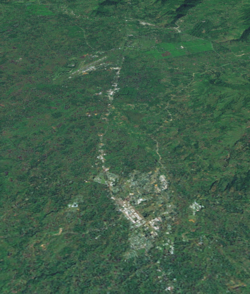
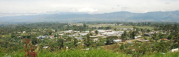
| 7 | Goroka Goroka Goroka is the capital of the Eastern Highlands Province of Papua New Guinea. It is a town of approximately 19,000 people , 1600m above sea level. It has an airport and is on the "Highlands Highway", about 285 km from Lae in Morobe province and 90 km from the nearby town of Kainantu also... * |
Eastern Highlands | 25,000 ~ |
| 8 | Kokopo Kokopo Kokopo is the capital of East New Britain in Papua New Guinea. The capital was moved from Rabaul in 1994 when the volcanoes Tavurvur and Vulcan erupted. As a result, the population of the town increased more than sixfold from 3,150 in 1990 to 20,262 in 2000.... * |
East New Britain | 20,262 |
| 9 | Popondetta Popondetta Popondetta is the capital of Oro Province in Papua New Guinea.In 1951 the town became the focus of relief efforts after nearby Mount Lamington erupted and killed 4,000 people.... * |
Oro Oro Province Oro Province, formerly Northern Province, is a coastal province of Papua New Guinea. The provincial capital is Popondetta. The province covers 22,800 km², and has 133,065 inhabitants .... |
19,556 |
| 10 | Mendi Mendi Mendi, Papua New Guinea, is the provincial capital of the Southern Highlands Province.... * |
Southern Highlands | 17,119 |
| * | Rabaul Rabaul Rabaul is a township in East New Britain province, Papua New Guinea. The town was the provincial capital and most important settlement in the province until it was destroyed in 1994 by falling ash of a volcanic eruption. During the eruption, ash was sent thousands of metres into the air and the... 1990 |
East New Britain | 17,044 |
| * | Hanuabada Village | National Capital District | 15,000 ~ |
| 11 | Kimbe Kimbe Kimbe is the capital of the province of West New Britain in Papua New Guinea. It is a port town on the great Kimbe Bay which boasts more than 60 percent of the coral species of the entire Indo-Pacific. The bustling town of Kimbe is the third largest port in Papua New Guinea and is the fastest... * |
West New Britain | 14,656 |
| 12 | Tabubil Tabubil Tabubil is a planned, company operated township located in the Star Mountains area of the North Fly District of Western Province, Papua New Guinea... |
Western Western Province (Papua New Guinea) Western Province is a coastal province in southwestern Papua New Guinea, bordering the Indonesian province of Papua. The provincial capital is Daru, on the island of Daru. The largest town in the province is Tabubil... |
13,800 ~ |
| 13 | Daru Daru Daru is the capital of the Western Province of Papua New Guinea. The township is entirely located on an island that goes by the same name, which is located near the mouth of the Fly River on the western side of the Gulf, just north of Torres Strait and Far North Queensland... * |
Western Western Province (Papua New Guinea) Western Province is a coastal province in southwestern Papua New Guinea, bordering the Indonesian province of Papua. The provincial capital is Daru, on the island of Daru. The largest town in the province is Tabubil... |
12,879 |
| 14 | Kavieng Kavieng Kavieng is the capital of the Papua New Guinean province of New Ireland and the largest town on the island of the same name. The town is located at Balgai Bay, on the northern tip of the island. As of 2000, it had a population of 10,600.... * |
New Ireland | 10,600 ~ |
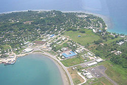
| 15 | Alotau Alotau Alotau is the capital of Milne Bay Province, a province of Papua New Guinea. It is located on the northern shore of Milne Bay.The town is located within the area in which the invading Japanese army suffered their first land defeat in the Pacific War in 1942, before the Kokoda Track battle. A... * |
Milne Bay Milne Bay Province Milne Bay is a province of Papua New Guinea. Its capital is Alotau. The province covers 14,000 km² of land and 252,990 km² of sea, within the province there are more than 600 islands, about 160 of which are inhabited... |
10,025 |
| 16 | Vanimo Vanimo Vanimo is the capital of Sandaun Province in Papua New Guinea. It is located on a peninsula close to the border with Indonesia.Vanimo is a small township with an economy based around the timber industry. Logging company Vanimo Forest Products, which is owned by Malaysian company Rimbunan Hijau, is... * |
Sandaun | 9,809 |
| 17 | Bulolo Bulolo Bulolo is a town in the Morobe Province of Papua New Guinea. It was once an important gold dredging centre in the former Territory of New Guinea, situated on the Bulolo River, a tributary of the Markham River, about north-west of Wau. The town is served by Bulolo Airport.Built in June 1930, the... |
Morobe Morobe Province Morobe Province is a province on the northern coast of Papua New Guinea. The provincial capital, and largest city, is Lae. The province covers 34,500 km², including 719 km² maritime area, with a population of 539,725... |
9,500 ~ |
| 18 | Kiunga Kiunga, Papua New Guinea Kiunga is a port town on the Fly River in the Western Province of Papua New Guinea, just upstream from the D'Albertis Junction with the Ok Tedi River. It is the southernmost terminus of the Kiunga-Tabubil Highway. Local industry rests on a cornerstone of freight and haulage, particularly from the... |
Western Western Province (Papua New Guinea) Western Province is a coastal province in southwestern Papua New Guinea, bordering the Indonesian province of Papua. The provincial capital is Daru, on the island of Daru. The largest town in the province is Tabubil... |
8,265 |
| 19 | Tari Tari, Papua New Guinea Tari Is the centre of Huli country in the Southern Highlands province of Papua New Guinea. It is the second largest settlement in the province, and accessible by road from Mendi.-Aviation Accidents:... |
Southern Highlands | 8,186 |
| 20 | Kundiawa Kundiawa Kundiawa is the capital of Simbu Province, Papua New Guinea, with a population of 8,147 . It lies along the Highlands Highway approximately halfway between Goroka and Mount Hagen, respectively the capitals of the Eastern Highlands and Western Highlands provinces.It is a relatively small town,... * |
Simbu Simbu Province Simbu, also known as Chimbu, is a Highlands Region province in Papua New Guinea. The province has an area of 6,100 km² and a population of 259,703 . The capital of the province is Kundiawa... |
8,147 |
| 21 | Aitape Aitape Aitape is a small town of about 8,000 people on the north coast of Papua New Guinea in the Sandaun Province. It is a coastal settlement that is almost equidistant from the provincial capitals of Wewak and Vanimo, and marks the midpoint of the highway between these two capitals... |
Sandaun | 8,000 ~ |
| 22 | Kainantu Kainantu Kainantu is a town in the Eastern Highlands of Papua New Guinea. It had some historical significance as an airstrip town during WWII. It functions primarily as a market town for local produce growers and cash croppers. It is located on the "Highlands Highway" approximately 170 km by road from Lae... |
Eastern Highlands | 6,723 |
| 23 | Lorengau Lorengau Lorengau is the major town in Manus Province, Papua New Guinea. The town is located on the edge of Seeadler Harbour on Manus Island, in the Admiralty Islands, and in 2000 Lorengau was recorded to have a population of 5,829.... * |
Manus Manus Province Manus Province is the smallest province in Papua New Guinea with a land area of 2,100 km², but with more than 220,000 km² of water. The capital of the province is Lorengau and the total population is 43,387 .... |
5,829 |
| 24 | Ialibu Ialibu Ialibu is a town in the Southern Highlands Province of Papua New Guinea, serving as the headquarters for the Ialibu-Pangia District.-Culture:... |
Southern Highlands | 5,478 |
| 25 | Kerema Kerema Kerema is the capital of Gulf Province, Papua New Guinea. It is located on the coast of Gulf of Papua. The Gulf region is aptly named for its concave coastline with large deltas. The Gulf area is a riparian region where many rivers from the southern slopes of the highlands drain into.-Culture and... * |
Gulf Gulf Province Gulf Province is a province of Papua New Guinea located on the southern coast. The provincial capital is Kerema. The 34,500 km² province is dominated by mountains, lowland river deltas, and grassland flood plains, the Kikori, Turama, Purari and Vailala rivers all meet the sea known as the... |
5,116 |
| 26 | Ningerum Ningerum Ningerum is a small town on the Kiunga-Tabubil Highway, about equidistant between the two centres of Kiunga and Tabubil. Ningerum is the seat of the Ningerum Rural LLG, which was the second most populous LLG in the North Fly District of the Western Province of Papua New Guinea during the 2000 census... |
Western Western Province (Papua New Guinea) Western Province is a coastal province in southwestern Papua New Guinea, bordering the Indonesian province of Papua. The provincial capital is Daru, on the island of Daru. The largest town in the province is Tabubil... |
5000 ~ |
| 26 | Wau | Morobe Morobe Province Morobe Province is a province on the northern coast of Papua New Guinea. The provincial capital, and largest city, is Lae. The province covers 34,500 km², including 719 km² maritime area, with a population of 539,725... |
5000 ~ |
| ? | Wabag Wabag Wabag is the capital of Enga Province, Papua New Guinea. It is the least populous provincial capital in the country. It is on the Lai River; the Highlands Highway passes through the town, between Mount Hagen and Porgera... * |
Enga Enga Province Enga refers to both an ethnic group located in the highlands of Papua New Guinea and the province in which they are the majority ethnic group.-Physical geography:... |
4,072 |
| ? | Rabaul Rabaul Rabaul is a township in East New Britain province, Papua New Guinea. The town was the provincial capital and most important settlement in the province until it was destroyed in 1994 by falling ash of a volcanic eruption. During the eruption, ash was sent thousands of metres into the air and the... |
East New Britain | 3,885 |
~ Is an estimated population, all other populations were determined by the most recent census, in the year 2000. The next PNG census will be held in 2010.
? Denotes a population with an undetermined rank.
Disaster and population shift
Natural and man-made disaster historically plays a major role in population shift in Papua New Guinea. The most notable are:| Disaster/Population Shift | Place where affected | Notes |
|---|---|---|
| 1994 volcanic eruption Rabaul caldera Rabaul caldera is a large volcano situated in East New Britain, Papua New Guinea. It derives its name from the town of Rabaul situated inside the caldera. The highest of its multiple peaks is .... |
|
Displaced thousands of residents. |
| 1997 Western Province Western Province (Papua New Guinea) Western Province is a coastal province in southwestern Papua New Guinea, bordering the Indonesian province of Papua. The provincial capital is Daru, on the island of Daru. The largest town in the province is Tabubil... drought Drought A drought is an extended period of months or years when a region notes a deficiency in its water supply. Generally, this occurs when a region receives consistently below average precipitation. It can have a substantial impact on the ecosystem and agriculture of the affected region... |
Tabubil Tabubil is a planned, company operated township located in the Star Mountains area of the North Fly District of Western Province, Papua New Guinea... Kiunga, Papua New Guinea Kiunga is a port town on the Fly River in the Western Province of Papua New Guinea, just upstream from the D'Albertis Junction with the Ok Tedi River. It is the southernmost terminus of the Kiunga-Tabubil Highway. Local industry rests on a cornerstone of freight and haulage, particularly from the... Mendi Mendi, Papua New Guinea, is the provincial capital of the Southern Highlands Province.... Tari, Papua New Guinea Tari Is the centre of Huli country in the Southern Highlands province of Papua New Guinea. It is the second largest settlement in the province, and accessible by road from Mendi.-Aviation Accidents:... Fly River The Fly at , is the second longest river, after the Sepik, in Papua New Guinea. The Fly is the largest river in Oceania, the largest in the world without a single dam in its catchment, and overall ranks as the twenty-fifth largest river in the world by volume of discharge... Southern Highlands (Papua New Guinea) Southern Highlands is a province in Papua New Guinea. Its provincial capital is the town of Mendi. According to Papua New Guinea's national 2000 census, the total population of Southern Highlands is 546,265 spread across , which makes it the most highly populated province in the country.-Split to... |
Left many agricultural communities in the highlands without food, and larger landlocked settlements that rely heavily on river shipping. Death toll is unknown. Many people permanently moved. |
| 1998 earthquake and tsunami 1998 Papua New Guinea earthquake The 1998 Papua New Guinea earthquake was a magnitude 7.0 earthquake that took place in the early evening of Friday, 17 July 1998. The earthquake struck the north coast region of Papua New Guinea, 25 km from the coast near Aitape, and caused a large undersea landslide, which in turn... |
Aitape Aitape is a small town of about 8,000 people on the north coast of Papua New Guinea in the Sandaun Province. It is a coastal settlement that is almost equidistant from the provincial capitals of Wewak and Vanimo, and marks the midpoint of the highway between these two capitals... Sandaun Sandaun Province, officially West Sepik Province, is the north-westernmost province of Papua New Guinea. It covers an area of 36,300 km² and has a population of 185,741 . The capital is Vanimo... Sepik Sepik may refer to places in Papua New Guinea:*Sepik River*East Sepik - a province*Sandaun - a province formerly known as West Sepik*Sepik region - consisting of East Sepik and Sandaun provincesIn languages it may refer to:... Delta |
Killed thousands of residents. Many places were also affected with disease afterward due to improper handling of the dead and greatly reduced living conditions. About 10,000 people became refugees. |
| Ongoing Bougainville conflict |
Arawa, Papua New Guinea Arawa is the disputed capital and largest settlement in Bougainville Province in Papua New Guinea. The land where Arawa is now situated was previously a large expatriate plantation.... Kieta Kieta is a port town located on the eastern coast of the island of Bougainville in Papua New Guinea, near the township of Arawa. After extensive destruction during the 1990 Civil Uprising on Bougainville, Kieta has few inhabitants now, and is known mainly for its transport connections .-History:On... Panguna Panguna is a town and a copper mine on Bougainville Island, Papua New Guinea. By the end of its operations on May 15, 1989 it was the largest open-cut mine in the world; it was also a major catalyst in the unrest in Bougainville in the 1970s and 1980s.- See also :* History of Bougainville*... Bougainville Island Bougainville Island is the main island of the Autonomous Region of Bougainville of Papua New Guinea. This region is also known as Bougainville Province or the North Solomons. The population of the province is 175,160 , which includes the adjacent island of Buka and assorted outlying islands... Buka Island Buka Island is the second largest island in the Papua New Guinean province of Bougainville.- History :Buka was first occupied by humans in paleolithic times, some 30,000 years ago... |
This conflict caused unmeasurable but significant displacement. The 2000 CIA world Factbook states that 20,000 lives were lost in the conflict by 1997. |
| Indonesian refugee population shift |
Western Province (Papua New Guinea) Western Province is a coastal province in southwestern Papua New Guinea, bordering the Indonesian province of Papua. The provincial capital is Daru, on the island of Daru. The largest town in the province is Tabubil... Sandaun Sandaun Province, officially West Sepik Province, is the north-westernmost province of Papua New Guinea. It covers an area of 36,300 km² and has a population of 185,741 . The capital is Vanimo... |
Many refugee camps exist on the border of Indonesia Indonesia Indonesia , officially the Republic of Indonesia , is a country in Southeast Asia and Oceania. Indonesia is an archipelago comprising approximately 13,000 islands. It has 33 provinces with over 238 million people, and is the world's fourth most populous country. Indonesia is a republic, with an... , such as Black Wara, one of the biggest. The population of the Western Province refugee camps during the 2000 census was set at around 10,000, although the number of Indonesian refugees in the country is much higher. |
| Squatter settlements |
|
Most population centres in Papua New Guinea have shantytown-styled settlements, referred to as squatter settlements. Many people move in and out of these settlements periodically, as village life becomes harder, the appeal of urban life and manufactured goods becomes greater, and efforts are made to disperse the residents. |
See also
- List of cities and towns in Papua New Guinea
- Districts and LLGs of Papua New GuineaDistricts and LLGs of Papua New Guinea||This page is a list of districts and Local-Level Government areas of Papua New Guinea.On the highest level, Papua New Guinea is divided into four Regions. Below, Papua New Guinea has 20 province-level divisions: 18 integrated provinces, the autonomous province of North Solomons and the National...
- Provinces of Papua New GuineaProvinces of Papua New GuineaThe provinces of Papua New Guinea are the primary administrative divisions of the country. Provincial governments are branches of the national government– Papua New Guinea is not a federation of provinces...