
1998 Papua New Guinea earthquake
Encyclopedia
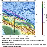
The 1998 Papua New Guinea earthquake was a magnitude 7.0 earthquake that took place in the early evening of Friday, 17 July 1998. The earthquake
struck the north coast region of Papua New Guinea
, 25 km (16 mi) from the coast near Aitape
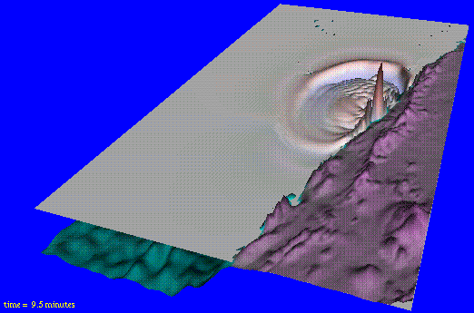
, and caused a large undersea landslide
, which in turn caused a tsunami
that hit the coast, killing more than 2200 people.
The area worst hit was a 30 km (19 mi) coastal strip running north-west from Aitape to the village of Sissano. Several villages in the path of the tsunami were completely destroyed and others extensively damaged. The village of Arop was situated on a narrow spit between the coast and Sissano lagoon. It was directly in the path of the tsunami and was worst hit.
 The earthquake occurred at 6:49pm local time (UTC+10
) along the boundary of the Australia and the Pacific
tetonic plates at 2.96°S 141.92°E. The result from the event was originally thought to have created a two-metre vertical drop in the Pacific Plate along a 40 km (25 mi) long crack. This was later revised to the tsunami actually being attributed to a massive underwater landslide.
The cause of the tsunami from the landslide has changed perceptions from scientists about small earthquakes generating undersea landslides, and made them realise that undersea landslides are more of a hazard, as they cause 'surprise' tsunamis, as there is less warning of an undersea landslide than an undersea earthquake, which is normally felt by people on land, and detected by the Pacific Tsunami Warning Center
. This has made them re-evaluate the tsunami risk around the world.
flew in three C-130 Hercules
transport planes with relief supplies. In the days following more relief was flown in and a field hospital
was set up in the neighbouring town of Vanimo
.
Earthquake
An earthquake is the result of a sudden release of energy in the Earth's crust that creates seismic waves. The seismicity, seismism or seismic activity of an area refers to the frequency, type and size of earthquakes experienced over a period of time...
struck the north coast region of Papua New Guinea
Papua New Guinea
Papua New Guinea , officially the Independent State of Papua New Guinea, is a country in Oceania, occupying the eastern half of the island of New Guinea and numerous offshore islands...
, 25 km (16 mi) from the coast near Aitape
Aitape
Aitape is a small town of about 8,000 people on the north coast of Papua New Guinea in the Sandaun Province. It is a coastal settlement that is almost equidistant from the provincial capitals of Wewak and Vanimo, and marks the midpoint of the highway between these two capitals...
, and caused a large undersea landslide
Landslide
A landslide or landslip is a geological phenomenon which includes a wide range of ground movement, such as rockfalls, deep failure of slopes and shallow debris flows, which can occur in offshore, coastal and onshore environments...
, which in turn caused a tsunami
Tsunami
A tsunami is a series of water waves caused by the displacement of a large volume of a body of water, typically an ocean or a large lake...
that hit the coast, killing more than 2200 people.
Effects
The tsunami resulted in at least 2,200 people being killed, thousands being injured, about 9,500 homeless and about 500 missing. The maximum height of the waves were estimated at being 15 m (59 ft) high with an average height of 10.5 m (34 ft).The area worst hit was a 30 km (19 mi) coastal strip running north-west from Aitape to the village of Sissano. Several villages in the path of the tsunami were completely destroyed and others extensively damaged. The village of Arop was situated on a narrow spit between the coast and Sissano lagoon. It was directly in the path of the tsunami and was worst hit.
Seismology
UTC+10
UTC+10 is an identifier for a time offset from UTC of +10. This time is used in:-As standard time :*Australia **Queensland*Federated States of Micronesia**Chuuk, Yap and surrounding area...
) along the boundary of the Australia and the Pacific
Pacific Plate
The Pacific Plate is an oceanic tectonic plate that lies beneath the Pacific Ocean. At 103 million square kilometres, it is the largest tectonic plate....
tetonic plates at 2.96°S 141.92°E. The result from the event was originally thought to have created a two-metre vertical drop in the Pacific Plate along a 40 km (25 mi) long crack. This was later revised to the tsunami actually being attributed to a massive underwater landslide.
The cause of the tsunami from the landslide has changed perceptions from scientists about small earthquakes generating undersea landslides, and made them realise that undersea landslides are more of a hazard, as they cause 'surprise' tsunamis, as there is less warning of an undersea landslide than an undersea earthquake, which is normally felt by people on land, and detected by the Pacific Tsunami Warning Center
Pacific Tsunami Warning Center
The Pacific Tsunami Warning Center is one of two tsunami warning centers that are operated by NOAA in the United States. Headquartered in Ewa Beach, Hawaii, the PTWC is part of an international tsunami warning system program and serves as the operational center for TWS of the Pacific issuing...
. This has made them re-evaluate the tsunami risk around the world.
Aid response
Immediately after the tsunami the Royal Australian Air ForceRoyal Australian Air Force
The Royal Australian Air Force is the air force branch of the Australian Defence Force. The RAAF was formed in March 1921. It continues the traditions of the Australian Flying Corps , which was formed on 22 October 1912. The RAAF has taken part in many of the 20th century's major conflicts...
flew in three C-130 Hercules
C-130 Hercules
The Lockheed C-130 Hercules is a four-engine turboprop military transport aircraft designed and built originally by Lockheed, now Lockheed Martin. Capable of using unprepared runways for takeoffs and landings, the C-130 was originally designed as a troop, medical evacuation, and cargo transport...
transport planes with relief supplies. In the days following more relief was flown in and a field hospital
Field hospital
A field hospital is a large mobile medical unit that temporarily takes care of casualties on-site before they can be safely transported to more permanent hospital facilities...
was set up in the neighbouring town of Vanimo
Vanimo
Vanimo is the capital of Sandaun Province in Papua New Guinea. It is located on a peninsula close to the border with Indonesia.Vanimo is a small township with an economy based around the timber industry. Logging company Vanimo Forest Products, which is owned by Malaysian company Rimbunan Hijau, is...
.