
Fly River
Encyclopedia
The Fly at 1050 kilometres (652.4 mi), is the second longest river
, after the Sepik
, in Papua New Guinea
. The Fly is the largest river in Oceania
, the largest in the world without a single dam
in its catchment, and overall ranks as the twenty-fifth largest river in the world by volume of discharge. It rises in the Victor Emanuel Range
arm of the Star Mountains
, and crosses the south-western lowlands before flowing into the Gulf of Papua
in a large delta
.
, though for a small stretch it forms the boundary between PNG and the Indonesia
province of Papua
. This section protrudes slightly to the west of the 141°E longitude line
. To compensate for this slight gain in territory for PNG, the border south of the Fly River is slightly east of the 141°E longitude line. As part of this deal, Indonesia has the right to use the Fly River to its mouth for navigation.
The principal tributaries of the Fly are the Strickland
and the Ok Tedi
.
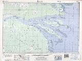
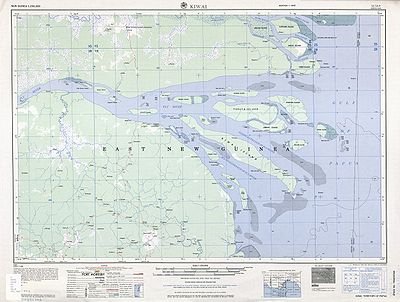
of the Fly River is 56 km wide at its entrance, but only 11 km wide abreast Kiwai Island
, which may be considered as being the river mouth. Above this island the river gradually contracts to a width of 1.6 kilometers or less.
The river delta is studded with low and swampy islands covered with mangrove and nipa palm. There are villages and cultivated areas on these islands. The land on both sides of the estuary is of the same character. The islands in the estuary are flat and are covered with a
thick, fertile alluvial soil. The largest islands are Kiwai Island
, Purutu Island
, Wabuda Island
, Aibinio Island, Mibu Island, and Domori Island. Kiwai, Wabuda and Domori are inhabited.
A list of the river delta islands is:
 The inhabitants of the Fly River delta engage in agriculture and hunting. Coconut palm, breadfruit, plantain, sago palm, and sugar cane are grown.
commanding the corvette
HMS Fly, surveryed the western coast of the Gulf of Papua. The river was named after his ship and he proclaimed that it would be possible for a small steam powered boat to travel up the mighty river.
In 1876 Italian explorer, Luigi D'Albertis
, was the first person to successfully attempt this when he travelled 900 km into the interior of New Guinea, in his steamer, Neva. It was the furthest any European explorer had ever been into the island.
and the Ok Tedi
river have been the source of environmental controversy due to tailings waste from the Porgera Mine and the Ok Tedi Mine
respectively. In 2008, Dr Ian Campbell, a former advisor to Ok Tedi Mining Limited
, claimed that company data suggests significant portions of the Fly River floodplain are at a high risk from acid mine drainage
.
River
A river is a natural watercourse, usually freshwater, flowing towards an ocean, a lake, a sea, or another river. In a few cases, a river simply flows into the ground or dries up completely before reaching another body of water. Small rivers may also be called by several other names, including...
, after the Sepik
Sepik
Sepik may refer to places in Papua New Guinea:*Sepik River*East Sepik - a province*Sandaun - a province formerly known as West Sepik*Sepik region - consisting of East Sepik and Sandaun provincesIn languages it may refer to:...
, in Papua New Guinea
Papua New Guinea
Papua New Guinea , officially the Independent State of Papua New Guinea, is a country in Oceania, occupying the eastern half of the island of New Guinea and numerous offshore islands...
. The Fly is the largest river in Oceania
Oceania
Oceania is a region centered on the islands of the tropical Pacific Ocean. Conceptions of what constitutes Oceania range from the coral atolls and volcanic islands of the South Pacific to the entire insular region between Asia and the Americas, including Australasia and the Malay Archipelago...
, the largest in the world without a single dam
Dam
A dam is a barrier that impounds water or underground streams. Dams generally serve the primary purpose of retaining water, while other structures such as floodgates or levees are used to manage or prevent water flow into specific land regions. Hydropower and pumped-storage hydroelectricity are...
in its catchment, and overall ranks as the twenty-fifth largest river in the world by volume of discharge. It rises in the Victor Emanuel Range
Victor Emanuel Range
The Victor Emanuel Range is a limestone mountain range in the New Guinea Highlands of western Papua New Guinea. It was named after the King of Italy by the Italian naturalist Luigi D'Albertis while he was charting the course of the Fly River, which originates at this range. To the north, the...
arm of the Star Mountains
Star Mountains
The Star Mountains are a mountain range in western Papua New Guinea, stretching from the border with Indonesia, at about to the Hindenburg Range...
, and crosses the south-western lowlands before flowing into the Gulf of Papua
Gulf of Papua
The Gulf of Papua is a 400 kilometer wide region on the south shore of New Guinea. Some of New Guinea's largest rivers, such as the Fly River, Turama River, Kikori River and Purari River, flow into the gulf, making it a large delta. While the western coast is characterized by swampy tidal...
in a large delta
River delta
A delta is a landform that is formed at the mouth of a river where that river flows into an ocean, sea, estuary, lake, reservoir, flat arid area, or another river. Deltas are formed from the deposition of the sediment carried by the river as the flow leaves the mouth of the river...
.
Description
The Fly flows mostly through the Western ProvinceWestern Province (Papua New Guinea)
Western Province is a coastal province in southwestern Papua New Guinea, bordering the Indonesian province of Papua. The provincial capital is Daru, on the island of Daru. The largest town in the province is Tabubil...
, though for a small stretch it forms the boundary between PNG and the Indonesia
Indonesia
Indonesia , officially the Republic of Indonesia , is a country in Southeast Asia and Oceania. Indonesia is an archipelago comprising approximately 13,000 islands. It has 33 provinces with over 238 million people, and is the world's fourth most populous country. Indonesia is a republic, with an...
province of Papua
Papua (Indonesian province)
Papua comprises most of the western half of the island of New Guinea and nearby islands. Its capital is Jayapura. It's the largest and easternmost province of Indonesia. The province originally covered the entire western half of New Guinea...
. This section protrudes slightly to the west of the 141°E longitude line
141st meridian east
The 141st meridian east of Greenwich is a line of longitude that extends extends from the North Pole across the Arctic Ocean, Asia, the Pacific Ocean, Australasia, the Indian Ocean, the Southern Ocean, and Antarctica to the South Pole....
. To compensate for this slight gain in territory for PNG, the border south of the Fly River is slightly east of the 141°E longitude line. As part of this deal, Indonesia has the right to use the Fly River to its mouth for navigation.
The principal tributaries of the Fly are the Strickland
Strickland River
The Strickland River is a river in the Western Province of Papua New Guinea, and is the largest tributary of the Fly River.- Environmental concerns :...
and the Ok Tedi
Ok Tedi River
The Ok Tedi is a river in New Guinea. The Ok Tedi Mine is located near the headwaters of the river, which is sourced in the Star Mountains. Nearly the entirety of the river runs through the North Fly District of the Western Province of Papua New Guinea, but the river crosses the international...
.
Delta
The estuaryEstuary
An estuary is a partly enclosed coastal body of water with one or more rivers or streams flowing into it, and with a free connection to the open sea....
of the Fly River is 56 km wide at its entrance, but only 11 km wide abreast Kiwai Island
Kiwai Island
Kiwai Island is the largest island in the Fly River delta, Papua New Guinea. It is 59 km long along the northwest-southeast axis from Wamimuba Point in the northwest to the village of Saguane in the south, and up to 9 km wide, with an average width of 5.6 km. Its area is 359 km²...
, which may be considered as being the river mouth. Above this island the river gradually contracts to a width of 1.6 kilometers or less.
The river delta is studded with low and swampy islands covered with mangrove and nipa palm. There are villages and cultivated areas on these islands. The land on both sides of the estuary is of the same character. The islands in the estuary are flat and are covered with a
thick, fertile alluvial soil. The largest islands are Kiwai Island
Kiwai Island
Kiwai Island is the largest island in the Fly River delta, Papua New Guinea. It is 59 km long along the northwest-southeast axis from Wamimuba Point in the northwest to the village of Saguane in the south, and up to 9 km wide, with an average width of 5.6 km. Its area is 359 km²...
, Purutu Island
Purutu Island
Purutu Island Is an island in the Fly River delta, Papua New Guinea. Its area is 186 km2....
, Wabuda Island
Wabuda Island
Wabuda Island is an island in the Fly River delta, Papua New Guinea. Its area is 109 km²....
, Aibinio Island, Mibu Island, and Domori Island. Kiwai, Wabuda and Domori are inhabited.
A list of the river delta islands is:
|
|
|
History
The Fly was first discovered by Europeans in 1842 when Francis BlackwoodFrancis Blackwood
Francis Blackwood may refer to:*Francis Price Blackwood , British naval officer who spent most of his time in colonial Australia*Francis Blackwood, 10th Baron Dufferin and Clandeboye , British peer...
commanding the corvette
Corvette
A corvette is a small, maneuverable, lightly armed warship, originally smaller than a frigate and larger than a coastal patrol craft or fast attack craft , although many recent designs resemble frigates in size and role...
HMS Fly, surveryed the western coast of the Gulf of Papua. The river was named after his ship and he proclaimed that it would be possible for a small steam powered boat to travel up the mighty river.
In 1876 Italian explorer, Luigi D'Albertis
Luigi D'Albertis
Luigi Maria D'Albertis was a flamboyant Italian naturalist and explorer who, in 1876, became the first person to chart the Fly River in Papua New Guinea. He took eight weeks to steam some 580 miles up the Fly River in an Australian launch, the Neva. On board as engineer was young Lawrence...
, was the first person to successfully attempt this when he travelled 900 km into the interior of New Guinea, in his steamer, Neva. It was the furthest any European explorer had ever been into the island.
Environmental issues
Both the StricklandStrickland River
The Strickland River is a river in the Western Province of Papua New Guinea, and is the largest tributary of the Fly River.- Environmental concerns :...
and the Ok Tedi
Ok Tedi River
The Ok Tedi is a river in New Guinea. The Ok Tedi Mine is located near the headwaters of the river, which is sourced in the Star Mountains. Nearly the entirety of the river runs through the North Fly District of the Western Province of Papua New Guinea, but the river crosses the international...
river have been the source of environmental controversy due to tailings waste from the Porgera Mine and the Ok Tedi Mine
Ok Tedi Mine
The Ok Tedi Mine is an open-pit copper and gold mine located near the headwaters of the Ok Tedi River, in the Star Mountains Rural LLG of the North Fly District of the Western Province of Papua New Guinea...
respectively. In 2008, Dr Ian Campbell, a former advisor to Ok Tedi Mining Limited
Ok Tedi Mining Limited
Ok Tedi Mining Limited is a Company from Papua New Guinea that administers the Ok Tedi Mine in the northern part of the Western Province. Its main office is located in a building known as the White House in Tabubil....
, claimed that company data suggests significant portions of the Fly River floodplain are at a high risk from acid mine drainage
Acid mine drainage
Acid mine drainage , or acid rock drainage , refers to the outflow of acidic water from metal mines or coal mines. However, other areas where the earth has been disturbed may also contribute acid rock drainage to the environment...
.