

List of cities in Nevada
Encyclopedia
There are 108 cities and towns in Nevada
, of which 19 are incorporated
. The terms "city" and "town" are interchangeable. The name of a municipal corporation can either be "City of (Name)" or "Town of (Name)" regardless of its population.
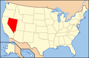

Nevada
Nevada is a state in the western, mountain west, and southwestern regions of the United States. With an area of and a population of about 2.7 million, it is the 7th-largest and 35th-most populous state. Over two-thirds of Nevada's people live in the Las Vegas metropolitan area, which contains its...
, of which 19 are incorporated
Municipal corporation
A municipal corporation is the legal term for a local governing body, including cities, counties, towns, townships, charter townships, villages, and boroughs. Municipal incorporation occurs when such municipalities become self-governing entities under the laws of the state or province in which...
. The terms "city" and "town" are interchangeable. The name of a municipal corporation can either be "City of (Name)" or "Town of (Name)" regardless of its population.
| Name | County | Population |
|---|---|---|
| Boulder City Boulder City, Nevada Boulder City is a city in Clark County, Nevada, United States. It is approximately from the City of Las Vegas. As of the 2010 census the population of Boulder City was 15,023.Boulder City is one of only two cities in Nevada that prohibit gambling.... |
Clark Clark County, Nevada -Demographics:As of the census of 2000, there were 1,375,765 people, 512,253 households, and 339,693 families residing within the MSA. The racial makeup of the MSA was 71.6% White , 9.1% Black, 5.7% Asian, 0.8% American Indian and 12.8% of other or mixed race. 22.0% were Hispanic of any race... |
15,005 |
| Caliente Caliente, Nevada Caliente , formerly known as Culverwell and Calientes is a town in Lincoln County, Nevada, United States. Its elevation is 4,300 feet . The population was 1,123 at the 2000 census... |
Lincoln Lincoln County, Nevada Lincoln County is a county located in the U.S. state of Nevada. As of the 2000 census, the population was 4,165. Its county seat is Pioche.-History:... |
1,123 |
| Carlin Carlin, Nevada Carlin is a city located near the western border of Elko County in northeast Nevada, west of the city of Elko. It is part of the Elko Micropolitan Statistical Area. Carlin sits along Interstate 80 at an elevation of approximately . As of the 2000 census, its population was 2,161... |
Elko Elko County, Nevada -Demographics:As of the census of 2000, there were 45,291 people, 15,638 households, and 11,493 families residing in the county. The population density was 3/sq mi . There were 18,456 housing units at an average density of 1/sq mi... |
2,161 |
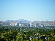
| Carson City †† Carson City, Nevada The Consolidated Municipality of Carson City is the capital of the state of Nevada. The words Consolidated Municipality refer to a series of changes in 1969 which abolished Ormsby County and merged all the settlements contained within its borders into Carson City. Since that time Carson City has... |
Carson City Carson City, Nevada The Consolidated Municipality of Carson City is the capital of the state of Nevada. The words Consolidated Municipality refer to a series of changes in 1969 which abolished Ormsby County and merged all the settlements contained within its borders into Carson City. Since that time Carson City has... |
52,547 |
| Ely Ely, Nevada Ely is the largest city and county seat of White Pine County, Nevada, United States. Ely was founded as a stagecoach station along the Pony Express and Central Overland Route. Ely's mining boom came later than the other towns along US 50, with the discovery of copper in 1906... |
White Pine White Pine County, Nevada White Pine County is a county located in the U.S. state of Nevada. Its population at the 2010 census was 10,030. Its county seat is Ely. It is the home of Great Basin National Park... |
4,041 |
| Elko † Elko, Nevada Elko is a city in Elko County, Nevada, United States. The population was 18,297 at the 2010 census. It is the county seat of Elko County. The city straddles the Humboldt River.... |
Elko Elko County, Nevada -Demographics:As of the census of 2000, there were 45,291 people, 15,638 households, and 11,493 families residing in the county. The population density was 3/sq mi . There were 18,456 housing units at an average density of 1/sq mi... |
16,980 |
| Fallon † Fallon, Nevada -Demographics:As of the census of 2000, there were 7,536 people, 3,004 households, and 1,877 families residing in the city. The population density was 2,474.1 people per square mile . There were 3,336 housing units at an average density of 1,095.2 per square mile... |
Churchill Churchill County, Nevada Churchill County is a county located in the western U.S. state of Nevada. As of the 2000 census, the population was 23,982. As of July 1, 2007, the population of Churchill County was estimated at 27,190. The county, named after Mexican-American War hero brevet Brigadier General Sylvester Churchill,... |
7,536 |
| Fernley Fernley, Nevada Fernley is a city in Lyon County, Nevada, United States, within Reno-Sparks-Lake Tahoe metropolitan. The city incorporated in 2001, including land in Washoe County; prior to that it was a census-designated place . The population of the CDP was 8,543 at the 2000 census; the city itself had an... |
Lyon Lyon County, Nevada Lyon County is a county located in the U.S. state of Nevada. As of the 2010 census, the population was 51,980. Its county seat is Yerington.-History:... |
12,673 |
| Henderson Henderson, Nevada -Demographics:According to the 2000 census, there were 175,381 people, 66,331 households, and 47,095 families residing in the city. The population density was 2,200.8 people per square mile . There were 71,149 housing units at an average density of 892.8 per square mile... |
Clark Clark County, Nevada -Demographics:As of the census of 2000, there were 1,375,765 people, 512,253 households, and 339,693 families residing within the MSA. The racial makeup of the MSA was 71.6% White , 9.1% Black, 5.7% Asian, 0.8% American Indian and 12.8% of other or mixed race. 22.0% were Hispanic of any race... |
252,064 |
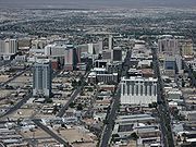
| Las Vegas † Las Vegas, Nevada Las Vegas is the most populous city in the U.S. state of Nevada and is also the county seat of Clark County, Nevada. Las Vegas is an internationally renowned major resort city for gambling, shopping, and fine dining. The city bills itself as The Entertainment Capital of the World, and is famous... |
Clark Clark County, Nevada -Demographics:As of the census of 2000, there were 1,375,765 people, 512,253 households, and 339,693 families residing within the MSA. The racial makeup of the MSA was 71.6% White , 9.1% Black, 5.7% Asian, 0.8% American Indian and 12.8% of other or mixed race. 22.0% were Hispanic of any race... |
567,641 |
| Lovelock † Lovelock, Nevada Lovelock is a city in western Nevada that is the county seat of Pershing County, the location of a prison, and the namesake of the area's Cold War gunnery range... |
Pershing Pershing County, Nevada Pershing County is a county located in the U.S. state of Nevada. As of the 2000 census, the population was 6,693. Its county seat is Lovelock. The county was named after army general John J. Pershing . It was formed from Humboldt County in 1919, and the last county to be established in... |
2,003 |
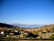
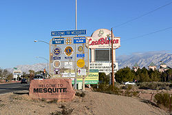
| Mesquite Mesquite, Nevada Mesquite is a city in Clark County, Nevada, United States, adjacent to the Arizona state line and northeast of Las Vegas. As of the 2010 United States Census, it had a population of 15,277. The city is located in the Virgin River Valley... |
Clark Clark County, Nevada -Demographics:As of the census of 2000, there were 1,375,765 people, 512,253 households, and 339,693 families residing within the MSA. The racial makeup of the MSA was 71.6% White , 9.1% Black, 5.7% Asian, 0.8% American Indian and 12.8% of other or mixed race. 22.0% were Hispanic of any race... |
9,389 |
| North Las Vegas North Las Vegas, Nevada North Las Vegas is a city in Clark County, Nevada, United States, located in the Las Vegas metropolitan area. The city was incorporated on May 16, 1946.-Geography:... |
Clark Clark County, Nevada -Demographics:As of the census of 2000, there were 1,375,765 people, 512,253 households, and 339,693 families residing within the MSA. The racial makeup of the MSA was 71.6% White , 9.1% Black, 5.7% Asian, 0.8% American Indian and 12.8% of other or mixed race. 22.0% were Hispanic of any race... |
224,387 |
| Reno † Reno, Nevada Reno is the county seat of Washoe County, Nevada, United States. The city has a population of about 220,500 and is the most populous Nevada city outside of the Las Vegas metropolitan area... |
Washoe Washoe County, Nevada Washoe County is a county located in the U.S. state of Nevada. The population was 421,407 at the 2010 census. Its county seat is Reno. Washoe County includes the Reno-Sparks metropolitan area.-History:... |
220,500 |
| Sparks Sparks, Nevada Sparks is a city in Washoe County, Nevada, United States, located east of Reno, Nevada. The 2010 U.S. Census Bureau population count was 90,264. Sparks is often referred to as half of a twin city .-Geography and Climate:... |
Washoe Washoe County, Nevada Washoe County is a county located in the U.S. state of Nevada. The population was 421,407 at the 2010 census. Its county seat is Reno. Washoe County includes the Reno-Sparks metropolitan area.-History:... |
88,602 |
| Wells Wells, Nevada Wells is a city in Elko County, in northeast Nevada in the western United States. The population was 1,346 at the 2000 census. Wells is located at the junction of U.S. Route 93 and Interstate 80, approximately east of Elko and is part of the Elko Micropolitan Statistical Area.-History:The site... |
Elko Elko County, Nevada -Demographics:As of the census of 2000, there were 45,291 people, 15,638 households, and 11,493 families residing in the county. The population density was 3/sq mi . There were 18,456 housing units at an average density of 1/sq mi... |
1,346 |
| West Wendover West Wendover, Nevada West Wendover is a city in Elko County, Nevada, United States. The population was 4,721 at the 2000 census. It is part of the Elko Micropolitan Statistical Area. West Wendover is located on the eastern border of Nevada and the western edge of the Great Salt Lake Desert, and is contiguous with... |
Elko Elko County, Nevada -Demographics:As of the census of 2000, there were 45,291 people, 15,638 households, and 11,493 families residing in the county. The population density was 3/sq mi . There were 18,456 housing units at an average density of 1/sq mi... |
4,721 |
| Winnemucca † Winnemucca, Nevada -Demographics:As of the census of 2000, there were 7,174 people, 2,736 households, and 1,824 families residing in the city. The population density was 867.5 people per square mile . There were 3,280 housing units at an average density of 396.6 per square mile... |
Humboldt Humboldt County, Nevada Humboldt County is a county located in the U.S. state of Nevada. As of 2007, the population was estimated to be 18,052. Its county seat is Winnemucca.The county was the site of an arrest in 2000 that led to the U.S. Supreme Court decision Hiibel v... |
7,174 |
| Yerington † Yerington, Nevada Yerington is a city in Lyon County, located in western Nevada, USA. The population was 2,883 at the 2000 census. It is named after Henry M. Yerington, Superintendent of the Virginia and Truckee Railroad from 1868 to 1910. It is the county seat of Lyon County.... |
Lyon Lyon County, Nevada Lyon County is a county located in the U.S. state of Nevada. As of the 2010 census, the population was 51,980. Its county seat is Yerington.-History:... |
2,883 |
| Name | Type of Settlement | County | Population |
|---|---|---|---|
| Alamo Alamo, Nevada Alamo is an unincorporated community in Lincoln County, Nevada, United States, about north of Las Vegas. Its elevation is 3,449 feet . It is named after the Spanish word for "poplar" due to the presence of that type of tree. Founded in 1901, Alamo lies in the Pahranagat Valley. Its economy is... |
Unincorporated | Lincoln Lincoln County, Nevada Lincoln County is a county located in the U.S. state of Nevada. As of the 2000 census, the population was 4,165. Its county seat is Pioche.-History:... |
427 |
| Amargosa Valley Amargosa Valley, Nevada Amargosa Valley is an unincorporated community in Nye County, in the U.S. state of Nevada.-Description:The community is named for the Amargosa River which flows through the valley from its origination in Nevada to its terminus in Death Valley, California... |
Unincorporated | Nye Nye County, Nevada -National protected areas:* Ash Meadows National Wildlife Refuge* Death Valley National Park * Humboldt-Toiyabe National Forest * Spring Mountains National Recreation Area -Demographics:... |
1,503 |
| Arden Arden, Nevada Arden, Nevada is an unincorporated community in Clark County, Nevada. Its ZIP code is 89118. Located about southwest of Las Vegas, the area is experiencing rapid growth in housing development on land formerly owned by the Bureau of Land Management.... |
Unincorporated | Clark Clark County, Nevada -Demographics:As of the census of 2000, there were 1,375,765 people, 512,253 households, and 339,693 families residing within the MSA. The racial makeup of the MSA was 71.6% White , 9.1% Black, 5.7% Asian, 0.8% American Indian and 12.8% of other or mixed race. 22.0% were Hispanic of any race... |
57,342 |
| Ash Springs Ash Springs, Nevada Ash Springs is a town in the Pahranagat Valley of Lincoln County, Nevada. The town's principal industry is ranching. The town is home to naturally occurring hot springs.... |
Unincorporated | Lincoln Lincoln County, Nevada Lincoln County is a county located in the U.S. state of Nevada. As of the 2000 census, the population was 4,165. Its county seat is Pioche.-History:... |
151 |
| Austin Austin, Nevada Austin is a small, unincorporated community located in Lander County, Nevada, in the United States. As of 2004, its population is approximately 340. It is located on the western slopes of the Toiyabe Range at an elevation of . U.S... |
Unincorporated | Lander Lander County, Nevada Lander County is a county located in the U.S. state of Nevada. As of the 2000 census, the population was 5,794. Its county seat is Battle Mountain.-History:... |
340 |
| Baker Baker, Nevada Baker, Nevada is a small community and census-designated place in White Pine County, Nevada. It is located from Great Basin National Park on State Route 487. The town is named after an early settler, George W. Baker... |
Unincorporated | White Pine White Pine County, Nevada White Pine County is a county located in the U.S. state of Nevada. Its population at the 2010 census was 10,030. Its county seat is Ely. It is the home of Great Basin National Park... |
382 |
| Battle Mountain † Battle Mountain, Nevada Battle Mountain is an unincorporated community and census-designated place in Lander County, Nevada, United States. The population was 2,871 at the 2000 census. Though it has no legal status as a municipality, it still functions as the county seat of Lander County... |
CDP | Lander Lander County, Nevada Lander County is a county located in the U.S. state of Nevada. As of the 2000 census, the population was 5,794. Its county seat is Battle Mountain.-History:... |
2,871 |
| Beatty Beatty, Nevada Beatty is a census-designated place along the Amargosa River in Nye County in the U.S. state of Nevada. U.S. Route 95 runs through the CDP, which lies between Tonopah, about to the north, and Las Vegas, about to the southeast. State Route 374 connects Beatty to Death Valley National Park, about ... |
CDP | Nye Nye County, Nevada -National protected areas:* Ash Meadows National Wildlife Refuge* Death Valley National Park * Humboldt-Toiyabe National Forest * Spring Mountains National Recreation Area -Demographics:... |
1,154 |
| Blue Diamond Blue Diamond, Nevada Blue Diamond is a census-designated place in Clark County, Nevada, United States. The population was 282 at the 2000 census.-Geography:Blue Diamond is located at .-Demographics:... |
CDP | Clark Clark County, Nevada -Demographics:As of the census of 2000, there were 1,375,765 people, 512,253 households, and 339,693 families residing within the MSA. The racial makeup of the MSA was 71.6% White , 9.1% Black, 5.7% Asian, 0.8% American Indian and 12.8% of other or mixed race. 22.0% were Hispanic of any race... |
282 |
| Bunkerville Bunkerville, Nevada Bunkerville is an unincorporated town in Clark County, Nevada, United States. The population was 1,014 at the 2000 census.-Geography:According to the United States Census Bureau, the census-designated place of Bunkerville has a total area of , of which, of it is land and of it is... |
CDP | Clark Clark County, Nevada -Demographics:As of the census of 2000, there were 1,375,765 people, 512,253 households, and 339,693 families residing within the MSA. The racial makeup of the MSA was 71.6% White , 9.1% Black, 5.7% Asian, 0.8% American Indian and 12.8% of other or mixed race. 22.0% were Hispanic of any race... |
1,014 |
| Cal-Nev-Ari Cal-Nev-Ari, Nevada Cal-Nev-Ari is a census-designated place and town in Clark County, Nevada, United States, near the state's southernmost point. As of the 2000 census, the town had a total population of 278... |
CDP | Clark Clark County, Nevada -Demographics:As of the census of 2000, there were 1,375,765 people, 512,253 households, and 339,693 families residing within the MSA. The racial makeup of the MSA was 71.6% White , 9.1% Black, 5.7% Asian, 0.8% American Indian and 12.8% of other or mixed race. 22.0% were Hispanic of any race... |
278 |
| Cold Springs Cold Springs, Nevada Cold Springs is a census-designated place in Washoe County, Nevada, United States. It is located just off U.S. Route 395 in the northwestern part of the Reno–Sparks Metropolitan Statistical Area, adjacent to the California state line... |
CDP | Washoe Washoe County, Nevada Washoe County is a county located in the U.S. state of Nevada. The population was 421,407 at the 2010 census. Its county seat is Reno. Washoe County includes the Reno-Sparks metropolitan area.-History:... |
3,834 |
| Dayton Dayton, Nevada Dayton is a census-designated place in Lyon County, Nevada, United States. The population was 5,907 at the 2000 census.-History:Dayton is at the western end of the Twenty-Six Mile Desert at a bend in the Carson River. Immigrants stopping there for water would consider whether to follow the river... |
CDP | Lyon Lyon County, Nevada Lyon County is a county located in the U.S. state of Nevada. As of the 2010 census, the population was 51,980. Its county seat is Yerington.-History:... |
5,907 |
| Denio Denio, Nevada Denio, Nevada is an unincorporated community that lies on the Nevada-Oregon state line in Humboldt County, Nevada and Harney County, Oregon, in the United States. The community is also known as Denio, Oregon. There was formerly a Denio, Oregon post office north of the state line. Most of the town... |
Unincorporated | Humboldt Humboldt County, Nevada Humboldt County is a county located in the U.S. state of Nevada. As of 2007, the population was estimated to be 18,052. Its county seat is Winnemucca.The county was the site of an arrest in 2000 that led to the U.S. Supreme Court decision Hiibel v... |
50 |
| Duckwater Duckwater, Nevada Duckwater is located in the central portion of the U.S. state of Nevada, at about the same latitude as Sacramento, California. It is in Nye County, on the eastern edge of the Duckwater Indian Reservation, near the Red Mountain Wilderness. The city of Las Vegas is about 200 miles to the... |
Unincorporated | Nye Nye County, Nevada -National protected areas:* Ash Meadows National Wildlife Refuge* Death Valley National Park * Humboldt-Toiyabe National Forest * Spring Mountains National Recreation Area -Demographics:... |
368 |
| Dyer Dyer, Nevada Dyer is a small village in Esmeralda County, Nevada with a population of 110 as of the 2000 census. Dyer is located on State Route 264, near Nevada's border with California in the Fish Lake Valley. Air transportation is available at Dyer Airport.... |
Unincorporated | Nye Nye County, Nevada -National protected areas:* Ash Meadows National Wildlife Refuge* Death Valley National Park * Humboldt-Toiyabe National Forest * Spring Mountains National Recreation Area -Demographics:... |
345 |
| Enterprise Enterprise, Nevada Enterprise is an unincorporated town in the Las Vegas metropolitan area in Clark County, Nevada, United States. The population was 14,676 at the 2000 census, and estimated at 78,488 in 2008... |
CDP | Clark Clark County, Nevada -Demographics:As of the census of 2000, there were 1,375,765 people, 512,253 households, and 339,693 families residing within the MSA. The racial makeup of the MSA was 71.6% White , 9.1% Black, 5.7% Asian, 0.8% American Indian and 12.8% of other or mixed race. 22.0% were Hispanic of any race... |
78,488 |
| Eureka † Eureka, Nevada Eureka is an unincorporated township in and the county seat of Eureka County, Nevada, United States. Eureka is by far the largest community in Eureka County... |
Unincorporated | Eureka Eureka County, Nevada Eureka County is a county located in the U.S. state of Nevada. As of the 2000 census, the population was 1,651. Its county seat is Eureka.Eureka County is part of the Elko Micropolitan Statistical Area.-History:... |
431 |
| Fallon Station Fallon Station, Nevada Fallon Station is a census-designated place in Churchill County, Nevada, United States. The population was 1,265 at the 2000 census.-Geography:Fallon Station is located at .... |
CDP | Churchill Churchill County, Nevada Churchill County is a county located in the western U.S. state of Nevada. As of the 2000 census, the population was 23,982. As of July 1, 2007, the population of Churchill County was estimated at 27,190. The county, named after Mexican-American War hero brevet Brigadier General Sylvester Churchill,... |
1,265 |
| Gabbs Gabbs, Nevada Gabbs is an unincorporated community in Nye County, Nevada, United States. The population was 318 at the 2000 census, at which time it was a city. Since then, it has been dis-incorporated, effective May 8, 2001.-History:... |
Unincorporated | Nye Nye County, Nevada -National protected areas:* Ash Meadows National Wildlife Refuge* Death Valley National Park * Humboldt-Toiyabe National Forest * Spring Mountains National Recreation Area -Demographics:... |
318 |
| Gardnervillle Gardnerville, Nevada Gardnerville is a census-designated place in Douglas County, Nevada, United States, adjacent to the county seat of Minden. The population was 3,357 at the 2000 census.... |
CDP | Douglas Douglas County, Nevada Douglas County is a county located in the northwestern part of the U.S. state of Nevada. As of 2000, the population was 41,259. As of 2010, the population was estimated to be 46,997.- History :... |
3,357 |
| Gardnerville Ranchos Gardnerville Ranchos, Nevada Gardnerville Ranchos is a census-designated place in Douglas County, Nevada, United States. As of the 2000 census, the CDP population was 11,054... |
CDP | Douglas Douglas County, Nevada Douglas County is a county located in the northwestern part of the U.S. state of Nevada. As of 2000, the population was 41,259. As of 2010, the population was estimated to be 46,997.- History :... |
11,054 |
| Genoa Genoa, Nevada Genoa is an unincorporated town in Douglas County, Nevada, United States. Founded in 1850, it was the first settlement in what became the Nevada Territory. It is situated within Carson River Valley and is about south of Reno.... |
Unincorporated | Douglas Douglas County, Nevada Douglas County is a county located in the northwestern part of the U.S. state of Nevada. As of 2000, the population was 41,259. As of 2010, the population was estimated to be 46,997.- History :... |
252 |
| Gerlach-Empire | CDP | Washoe Washoe County, Nevada Washoe County is a county located in the U.S. state of Nevada. The population was 421,407 at the 2010 census. Its county seat is Reno. Washoe County includes the Reno-Sparks metropolitan area.-History:... |
499 |
| Glenbrook Glenbrook, Nevada Glenbrook is an unincorporated community in Douglas County, Nevada, United States. The community is named after the Glenbrook House hotel and is at an elevation of... |
Unincorporated | Douglas Douglas County, Nevada Douglas County is a county located in the northwestern part of the U.S. state of Nevada. As of 2000, the population was 41,259. As of 2010, the population was estimated to be 46,997.- History :... |
6,694 |
| Goldfield † Goldfield, Nevada Goldfield is an unincorporated community and the county seat of Esmeralda County, Nevada, United States, with a resident population of 440 at the 2000 census. It is located about southeast of Carson City, along U.S... |
Unincorporated | Esmeralda Esmeralda County, Nevada Esmeralda County is a county in the west of U.S. state of Nevada. Its county seat is Goldfield. Its 2000 census population was officially 971, making its population density 0.1045 inhabitants/km² , the second-lowest of any county-equivalent outside of Alaska. As of 2010, the population had... |
440 |
| Gold Hill Gold Hill, Nevada Gold Hill is a community in Storey County, Nevada, located just south and downhill of Virginia City. Incorporated December 17, 1862, in order to prevent its annexation by its larger neighbor, the town at one point was home to at least 8,000 residents. Prosperity was sustained for a period of 20... |
Unincorporated | Storey Storey County, Nevada Storey County is a county located in the U.S. state of Nevada. As of the 2000 census, the population was 3,399, which was estimated to have risen to 4,110 in 2006... |
191 |
| Goodsprings Goodsprings, Nevada Goodsprings is a census-designated place in Clark County, Nevada, United States. The population was 232 at the 2000 census.-Geography:Goodsprings is located at .... |
CDP | Clark Clark County, Nevada -Demographics:As of the census of 2000, there were 1,375,765 people, 512,253 households, and 339,693 families residing within the MSA. The racial makeup of the MSA was 71.6% White , 9.1% Black, 5.7% Asian, 0.8% American Indian and 12.8% of other or mixed race. 22.0% were Hispanic of any race... |
232 |
| Hawthorne † Hawthorne, Nevada Hawthorne is a census-designated place in Mineral County, Nevada, United States. The population was 3,311 at the 2000 census. It is the county seat of Mineral County... |
CDP | Mineral Mineral County, Nevada Mineral County is a county located in the U.S. state of Nevada. As of the 2000 census, the population was 5,071. In 2009, it was estimated to have dropped to 4,662. Its county seat is Hawthorne.-History:... |
3,311 |
| Imlay Imlay, Nevada Imlay is a small town in Pershing County, Nevada. It has an elementary school, a general store, a post office, and a trading post.As of 2005, the population of Imlay, Nevada, was 233.... |
Unincorporated | Pershing Pershing County, Nevada Pershing County is a county located in the U.S. state of Nevada. As of the 2000 census, the population was 6,693. Its county seat is Lovelock. The county was named after army general John J. Pershing . It was formed from Humboldt County in 1919, and the last county to be established in... |
233 |
| Incline Village-Crystal Bay | CDP | Washoe Washoe County, Nevada Washoe County is a county located in the U.S. state of Nevada. The population was 421,407 at the 2010 census. Its county seat is Reno. Washoe County includes the Reno-Sparks metropolitan area.-History:... |
9,952 |
| Indian Hills Indian Hills, Nevada Indian Hills is a census-designated place in Douglas County, Nevada, United States. It lies in the south side of the Carson City metropolitan area... |
CDP | Douglas Douglas County, Nevada Douglas County is a county located in the northwestern part of the U.S. state of Nevada. As of 2000, the population was 41,259. As of 2010, the population was estimated to be 46,997.- History :... |
4,407 |
| Indian Springs Indian Springs, Nevada Indian Springs is an unincorporated town in Clark County, Nevada, United States. The population was 1,302 at the 2000 census.-History:Indian Springs is named for the artesian spring that provides the area with water... |
CDP | Clark Clark County, Nevada -Demographics:As of the census of 2000, there were 1,375,765 people, 512,253 households, and 339,693 families residing within the MSA. The racial makeup of the MSA was 71.6% White , 9.1% Black, 5.7% Asian, 0.8% American Indian and 12.8% of other or mixed race. 22.0% were Hispanic of any race... |
1,302 |
| Jackpot Jackpot, Nevada Jackpot is an unincorporated community in Elko County, Nevada, United States. The Zip Code Tabulation Area for its ZIP code, 89825, had a population of 1,189 as of the 2010 census. Located less than 1 mile from the Idaho border on U.S... |
Unincorporated | Elko Elko County, Nevada -Demographics:As of the census of 2000, there were 45,291 people, 15,638 households, and 11,493 families residing in the county. The population density was 3/sq mi . There were 18,456 housing units at an average density of 1/sq mi... |
1,416 |
| Jarbidge Jarbidge, Nevada Jarbidge is an unincorporated community in Elko County, Nevada, United States. It lies on the edge of the Jarbidge Wilderness, several miles south of the Idaho/Nevada border. Noted locally for its remoteness, the community is usually accessed by road from Rogerson in Twin Falls County, Idaho... |
Unincorporated | Elko Elko County, Nevada -Demographics:As of the census of 2000, there were 45,291 people, 15,638 households, and 11,493 families residing in the county. The population density was 3/sq mi . There were 18,456 housing units at an average density of 1/sq mi... |
1,017 |
| Jean Jean, Nevada Jean is a small commercial town in Clark County, Nevada, located approximately north of the Nevada-California state line along Interstate 15. Las Vegas is located about to the north... |
Unincorporated | Clark Clark County, Nevada -Demographics:As of the census of 2000, there were 1,375,765 people, 512,253 households, and 339,693 families residing within the MSA. The racial makeup of the MSA was 71.6% White , 9.1% Black, 5.7% Asian, 0.8% American Indian and 12.8% of other or mixed race. 22.0% were Hispanic of any race... |
0 |
| Johnson Lane Johnson Lane, Nevada Johnson Lane is a census-designated place in Douglas County, Nevada, United States. It lies in the south side of the Carson City metropolitan area... |
CDP | Douglas Douglas County, Nevada Douglas County is a county located in the northwestern part of the U.S. state of Nevada. As of 2000, the population was 41,259. As of 2010, the population was estimated to be 46,997.- History :... |
4,837 |
| Kingsbury Kingsbury, Nevada Kingsbury is a census-designated place in Douglas County, Nevada, United States. The population was 2,624 at the 2000 census.-Geography:Kingsbury is located at .... |
CDP | Douglas Douglas County, Nevada Douglas County is a county located in the northwestern part of the U.S. state of Nevada. As of 2000, the population was 41,259. As of 2010, the population was estimated to be 46,997.- History :... |
2,624 |
| Kingston Kingston, Nevada Kingston is a small town in Lander County, Nevada. As of 2005, the estimated population of Kingston is 288.-References:... |
Unincorporated | Lander Lander County, Nevada Lander County is a county located in the U.S. state of Nevada. As of the 2000 census, the population was 5,794. Its county seat is Battle Mountain.-History:... |
288 |
| Lamoille Lamoille, Nevada Lamoille is a rural unincorporated community in Elko County in the northeastern section of the state of Nevada in the western United States. It is located about east of Elko at the base of the Ruby Mountains at an elevation of and is part of the Elko Micropolitan Statistical Area.The early... |
Unincorporated | Elko Elko County, Nevada -Demographics:As of the census of 2000, there were 45,291 people, 15,638 households, and 11,493 families residing in the county. The population density was 3/sq mi . There were 18,456 housing units at an average density of 1/sq mi... |
10,548 |
| Laughlin Laughlin, Nevada Laughlin is a census-designated place in Clark County, Nevada, United States, and a port located on the Colorado River. Laughlin is south of Las Vegas, located in the far southern tip of Nevada. It is best known for its gaming, entertainment, and water recreation. As of the 2010 census, the... |
CDP | Clark Clark County, Nevada -Demographics:As of the census of 2000, there were 1,375,765 people, 512,253 households, and 339,693 families residing within the MSA. The racial makeup of the MSA was 71.6% White , 9.1% Black, 5.7% Asian, 0.8% American Indian and 12.8% of other or mixed race. 22.0% were Hispanic of any race... |
7,076 |
| Lemmon Valley-Golden Valley Lemmon Valley-Golden Valley, Nevada Lemmon Valley-Golden Valley is a census-designated place in Washoe County, Nevada, United States. The population was 6,855 at the 2000 census... |
CDP | Washoe Washoe County, Nevada Washoe County is a county located in the U.S. state of Nevada. The population was 421,407 at the 2010 census. Its county seat is Reno. Washoe County includes the Reno-Sparks metropolitan area.-History:... |
6,855 |
| Lund Lund, Nevada Lund is a small town and census-designated place in White Pine County, Nevada. Lund was named for Anthon H. Lund. Lund was settled in 1898. It was settled on land that the United States government had given The Church of Jesus Christ of Latter-day Saints in lieu of land that had been confiscated... |
Unincorporated | White Pine White Pine County, Nevada White Pine County is a county located in the U.S. state of Nevada. Its population at the 2010 census was 10,030. Its county seat is Ely. It is the home of Great Basin National Park... |
156 |
| Luning Luning, Nevada Luning is an Unincorporated Town in Mineral County, Nevada, in the United States. It is often listed as a ghost town, but it is not. The population of Luning, Nevada, as of 2005 is 87. The town ZIP Code of Luning is 89420.... |
Unincorporated | Mineral Mineral County, Nevada Mineral County is a county located in the U.S. state of Nevada. As of the 2000 census, the population was 5,071. In 2009, it was estimated to have dropped to 4,662. Its county seat is Hawthorne.-History:... |
87 |
| McDermitt | CDP | Humboldt Humboldt County, Nevada Humboldt County is a county located in the U.S. state of Nevada. As of 2007, the population was estimated to be 18,052. Its county seat is Winnemucca.The county was the site of an arrest in 2000 that led to the U.S. Supreme Court decision Hiibel v... |
269 |
| McGill McGill, Nevada McGill is a census-designated place in White Pine County, Nevada, United States. The population was 1,148 at the 2010 census.-Geography:McGill is located at .... |
CDP | White Pine White Pine County, Nevada White Pine County is a county located in the U.S. state of Nevada. Its population at the 2010 census was 10,030. Its county seat is Ely. It is the home of Great Basin National Park... |
1,054 |
| Mina Mina, Nevada Mina is a small community in Mineral County in west-central Nevada on U.S. Route 95 at an elevation of . The 2010 population was 155.-History:... |
Unincorporated | Mineral Mineral County, Nevada Mineral County is a county located in the U.S. state of Nevada. As of the 2000 census, the population was 5,071. In 2009, it was estimated to have dropped to 4,662. Its county seat is Hawthorne.-History:... |
261 |
| Minden † Minden, Nevada Minden is a census-designated place in Douglas County, Nevada, United States. The population was 2,836 at the 2000 census. It is the county seat of Douglas County and is adjacent to the city of Gardnerville. It is named after the town of Minden, in the German state of North Rhine-Westphalia. It... |
CDP | Douglas Douglas County, Nevada Douglas County is a county located in the northwestern part of the U.S. state of Nevada. As of 2000, the population was 41,259. As of 2010, the population was estimated to be 46,997.- History :... |
2,836 |
| Moapa Town Moapa Town, Nevada Moapa Town is a census-designated place in Clark County, Nevada, United States. The population was 928 at the 2000 census. It is the largest town in Clark County by land area... |
CDP | Clark Clark County, Nevada -Demographics:As of the census of 2000, there were 1,375,765 people, 512,253 households, and 339,693 families residing within the MSA. The racial makeup of the MSA was 71.6% White , 9.1% Black, 5.7% Asian, 0.8% American Indian and 12.8% of other or mixed race. 22.0% were Hispanic of any race... |
928 |
| Moapa Valley Moapa Valley, Nevada Moapa Valley is an unincorporated town in Clark County, Nevada, United States. The valley in which the community lies, also named Moapa Valley, is about long and lies roughly northwest to southeast.-Geography:... |
CDP | Clark Clark County, Nevada -Demographics:As of the census of 2000, there were 1,375,765 people, 512,253 households, and 339,693 families residing within the MSA. The racial makeup of the MSA was 71.6% White , 9.1% Black, 5.7% Asian, 0.8% American Indian and 12.8% of other or mixed race. 22.0% were Hispanic of any race... |
5,784 |
| Montello Montello, Nevada Montello is an unincorporated community in Elko County, Nevada, United States. It is home to Montello Elementary School which is part of the Elko County School District. The population of Montello is 216. Two small bars and a market/motel selling fuel & sundries comprise the business district... |
Unincorporated | Elko Elko County, Nevada -Demographics:As of the census of 2000, there were 45,291 people, 15,638 households, and 11,493 families residing in the county. The population density was 3/sq mi . There were 18,456 housing units at an average density of 1/sq mi... |
216 |
| Mount Charleston Mount Charleston, Nevada Mount Charleston is an unincorporated town in Clark County, Nevada, United States. The population was 285 at the 2000 census.Named for Mount Charleston, the highest point in the area, the town is in a valley of the Spring Mountains to the northwest of Las Vegas, noted for its hiking trails, and for... |
CDP | Clark Clark County, Nevada -Demographics:As of the census of 2000, there were 1,375,765 people, 512,253 households, and 339,693 families residing within the MSA. The racial makeup of the MSA was 71.6% White , 9.1% Black, 5.7% Asian, 0.8% American Indian and 12.8% of other or mixed race. 22.0% were Hispanic of any race... |
285 |
| Nixon Nixon, Nevada Nixon is a census-designated place in Washoe County, Nevada, USA. The population was 418 at the 2000 census. It is part of the Reno–Sparks Metropolitan Statistical Area... |
CDP | Washoe Washoe County, Nevada Washoe County is a county located in the U.S. state of Nevada. The population was 421,407 at the 2010 census. Its county seat is Reno. Washoe County includes the Reno-Sparks metropolitan area.-History:... |
418 |
| Owyhee Owyhee, Nevada Owyhee is a census-designated place in Elko County, Nevada, United States. The population was 1,017 at the 2000 census. It is part of the Elko Micropolitan Statistical Area.... |
CDP | Elko Elko County, Nevada -Demographics:As of the census of 2000, there were 45,291 people, 15,638 households, and 11,493 families residing in the county. The population density was 3/sq mi . There were 18,456 housing units at an average density of 1/sq mi... |
1,017 |
| Pahrump Pahrump, Nevada -Demographics:As of the census of 2000, there were 24,631 people, 10,153 households, and 7,127 families residing in the CDP. The population density was 82.7 people per square mile . There were 11,651 housing units at an average density of 39.1 per square mile... |
CDP | Nye Nye County, Nevada -National protected areas:* Ash Meadows National Wildlife Refuge* Death Valley National Park * Humboldt-Toiyabe National Forest * Spring Mountains National Recreation Area -Demographics:... |
41,654 |
| Panaca Panaca, Nevada Panaca is a town in eastern Lincoln County, Nevada, on State Route 319, about 1 mile east of U.S. Route 93, near the border with Utah. Its elevation is 4,729 feet .-History:... |
Unincorporated | Lincoln Lincoln County, Nevada Lincoln County is a county located in the U.S. state of Nevada. As of the 2000 census, the population was 4,165. Its county seat is Pioche.-History:... |
595 |
| Paradise Paradise, Nevada Paradise is an unincorporated town in the Las Vegas metropolitan area in Clark County, Nevada, United States. The population was 223,167 at the 2010 census... |
CDP | Clark Clark County, Nevada -Demographics:As of the census of 2000, there were 1,375,765 people, 512,253 households, and 339,693 families residing within the MSA. The racial makeup of the MSA was 71.6% White , 9.1% Black, 5.7% Asian, 0.8% American Indian and 12.8% of other or mixed race. 22.0% were Hispanic of any race... |
196,821 |
| Paradise Valley Paradise Valley, Nevada Paradise Valley is an unincorporated community in Humboldt County, Nevada, near the southeastern boundary of Humboldt National Forest. It is about fifteen miles east of Orovada and U.S... |
Unincorporated | Humboldt Humboldt County, Nevada Humboldt County is a county located in the U.S. state of Nevada. As of 2007, the population was estimated to be 18,052. Its county seat is Winnemucca.The county was the site of an arrest in 2000 that led to the U.S. Supreme Court decision Hiibel v... |
308 |
| Pioche † Pioche, Nevada -External links:*... |
Unincorporated | Lincoln Lincoln County, Nevada Lincoln County is a county located in the U.S. state of Nevada. As of the 2000 census, the population was 4,165. Its county seat is Pioche.-History:... |
900 |
| Primm Primm, Nevada Primm is a tiny community in Clark County, Nevada, United States, primarily notable for its position straddling Interstate 15 where it crosses the border between California and Nevada... |
Unincorporated | Clark Clark County, Nevada -Demographics:As of the census of 2000, there were 1,375,765 people, 512,253 households, and 339,693 families residing within the MSA. The racial makeup of the MSA was 71.6% White , 9.1% Black, 5.7% Asian, 0.8% American Indian and 12.8% of other or mixed race. 22.0% were Hispanic of any race... |
1,132 |
| Rachel Rachel, Nevada Rachel is an unincorporated portion of Lincoln County, Nevada. As the closest habitation to the Nellis Air Force Range and Area 51, Rachel enjoys a modest celebrity, particularly among aviation enthusiasts and UFO hunters.... |
Unincorporated | Lincoln Lincoln County, Nevada Lincoln County is a county located in the U.S. state of Nevada. As of the 2000 census, the population was 4,165. Its county seat is Pioche.-History:... |
80 |
| Round Mountain Round Mountain, Nevada Round Mountain is a small town in Nye County, Nevada. The population of Round Mountain, Nevada as of 2005 is 744 .Round Mountain is best known for the Round Mountain Gold Mine, a large open pit heap-leach gold mine owned by Kinross Gold Corporation and Barrick Gold Corporation... |
Unincorporated | Nye Nye County, Nevada -National protected areas:* Ash Meadows National Wildlife Refuge* Death Valley National Park * Humboldt-Toiyabe National Forest * Spring Mountains National Recreation Area -Demographics:... |
744 |
| Ruth Ruth, Nevada Ruth is a small town in White Pine County, Nevada, that was founded in 1903. It is a census-designated place, with a population in 2010 of 440.- History :Ruth began as a settlement for workers of the White Pine Copper Company in 1903... |
Unincorporated | White Pine White Pine County, Nevada White Pine County is a county located in the U.S. state of Nevada. Its population at the 2010 census was 10,030. Its county seat is Ely. It is the home of Great Basin National Park... |
512 |
| Sandy Valley Sandy Valley, Nevada Sandy Valley is a census-designated place in the Mesquite Valley in west-central Clark County, Nevada, United States. Sandy Valley has variant name of Sandy, Nevada. The population was 1,804 at the 2000 census. Sandy Valley is bordered on the East by the southern extension of the Spring Mountains... |
CDP | Clark Clark County, Nevada -Demographics:As of the census of 2000, there were 1,375,765 people, 512,253 households, and 339,693 families residing within the MSA. The racial makeup of the MSA was 71.6% White , 9.1% Black, 5.7% Asian, 0.8% American Indian and 12.8% of other or mixed race. 22.0% were Hispanic of any race... |
1,804 |
| Schurz Schurz, Nevada Schurz is a census-designated place in Mineral County, Nevada, United States. The population was 721 at the 2000 census. It is located on the Walker River Indian Reservation. It is the burial place of Wovoka, the Paiute messiah who originated the Ghost Dance movement... |
CDP | Mineral Mineral County, Nevada Mineral County is a county located in the U.S. state of Nevada. As of the 2000 census, the population was 5,071. In 2009, it was estimated to have dropped to 4,662. Its county seat is Hawthorne.-History:... |
721 |
| Searchlight Searchlight, Nevada Searchlight is an unincorporated town in Clark County, Nevada, at the topographic saddle between two mountain ranges.-History:According to Nevada Senator Harry Reid, who has written extensively about his hometown, the most likely story as to how the town received its name was when George Frederick... |
CDP | Clark Clark County, Nevada -Demographics:As of the census of 2000, there were 1,375,765 people, 512,253 households, and 339,693 families residing within the MSA. The racial makeup of the MSA was 71.6% White , 9.1% Black, 5.7% Asian, 0.8% American Indian and 12.8% of other or mixed race. 22.0% were Hispanic of any race... |
576 |
| Silver Peak Silver Peak, Nevada Silver Peak is an unincorporated community in Esmeralda County, Nevada, United States. It lies along State Route 265 south of U.S. Route 6 and west of Goldfield, the county seat of Esmeralda County. Its elevation is 4,321 feet . Although it is unincorporated, it has a post office, with the... |
Unincorporated | Esmeralda Esmeralda County, Nevada Esmeralda County is a county in the west of U.S. state of Nevada. Its county seat is Goldfield. Its 2000 census population was officially 971, making its population density 0.1045 inhabitants/km² , the second-lowest of any county-equivalent outside of Alaska. As of 2010, the population had... |
397 |
| Silver City Silver City, Nevada Silver City is a town in Lyon County, Nevada, USA, near the Lyon/Carson border. The population as of the 2000 census was 170.... |
Unincorporated | Lyon Lyon County, Nevada Lyon County is a county located in the U.S. state of Nevada. As of the 2010 census, the population was 51,980. Its county seat is Yerington.-History:... |
170 |
| Silver Springs Silver Springs, Nevada Silver Springs is a census-designated place in Lyon County, Nevada, United States at the intersection of U.S. 50 and U.S. 95A. The population was 4,708 at the 2000 census. Lahontan Reservoir, Lahontan State Recreation Area and historic Fort Churchill State Historic Park are all located nearby... |
CDP | Lyon Lyon County, Nevada Lyon County is a county located in the U.S. state of Nevada. As of the 2010 census, the population was 51,980. Its county seat is Yerington.-History:... |
4,708 |
| Smith Valley Smith Valley, Nevada Smith Valley is a census-designated place in Lyon County, Nevada, United States. The population was 1,425 at the 2000 census.-Geography:Smith Valley is located at .... |
CDP | Lyon Lyon County, Nevada Lyon County is a county located in the U.S. state of Nevada. As of the 2010 census, the population was 51,980. Its county seat is Yerington.-History:... |
1,425 |
| Spanish Springs Spanish Springs, Nevada Spanish Springs is a census-designated place in Washoe County, Nevada, United States. It is located in the northeastern part of the Reno–Sparks Metropolitan Statistical Area. The population was 15,064 at the 2010 Census.-History:... |
CDP | Washoe Washoe County, Nevada Washoe County is a county located in the U.S. state of Nevada. The population was 421,407 at the 2010 census. Its county seat is Reno. Washoe County includes the Reno-Sparks metropolitan area.-History:... |
9,018 |
| Spring Creek Spring Creek, Nevada Spring Creek is a census-designated place in central Elko County, in northeastern Nevada in the western United States. It mainly serves as a bedroom community for the businesses and industries in and around the nearby city of Elko. It is part of the Elko Micropolitan Statistical Area... |
CDP | Elko Elko County, Nevada -Demographics:As of the census of 2000, there were 45,291 people, 15,638 households, and 11,493 families residing in the county. The population density was 3/sq mi . There were 18,456 housing units at an average density of 1/sq mi... |
10,548 |
| Spring Valley Spring Valley, Nevada Spring Valley is an unincorporated town in Clark County, Nevada, United States located two miles west of the Las Vegas Strip. The population was 117,390 at the 2000 census.-Background:... |
CDP | Clark Clark County, Nevada -Demographics:As of the census of 2000, there were 1,375,765 people, 512,253 households, and 339,693 families residing within the MSA. The racial makeup of the MSA was 71.6% White , 9.1% Black, 5.7% Asian, 0.8% American Indian and 12.8% of other or mixed race. 22.0% were Hispanic of any race... |
117,390 |
| Stagecoach Stagecoach, Nevada Stagecoach is an unincorporated community in Lyon County, Nevada, United States, located east of Reno. Its name is likely derived from its place as the Overland Stagecoach station at Desert Well. Typically, the mail that was heading towards California was delivered on a steamship through Panama... |
Unincorporated | Lyon Lyon County, Nevada Lyon County is a county located in the U.S. state of Nevada. As of the 2010 census, the population was 51,980. Its county seat is Yerington.-History:... |
6,727 |
| Stateline Stateline, Nevada -Demographics:As of the census of 2000, there were 1,215 people, 510 households, and 245 families residing in the CDP. The population density was 1,803.3 people per square mile . There were 562 housing units at an average density of 834.1 per square mile... |
CDP | Douglas Douglas County, Nevada Douglas County is a county located in the northwestern part of the U.S. state of Nevada. As of 2000, the population was 41,259. As of 2010, the population was estimated to be 46,997.- History :... |
1,215 |
| Summerlin South Summerlin South, Nevada Summerlin South, also seen on maps as South Summerlin, is an affluent census-designated place in Clark County, Nevada, United States, on the western edge of Las Vegas and adjacent to the Red Rock Canyon National Conservation Area. It is so named because it is a southward extension of the... |
CDP | Clark Clark County, Nevada -Demographics:As of the census of 2000, there were 1,375,765 people, 512,253 households, and 339,693 families residing within the MSA. The racial makeup of the MSA was 71.6% White , 9.1% Black, 5.7% Asian, 0.8% American Indian and 12.8% of other or mixed race. 22.0% were Hispanic of any race... |
28,254 |
| Sun Valley Sun Valley, Nevada Sun Valley is a census-designated place in Washoe County, Nevada, USA. The population was 19,461 at the 2000 census. It is a northern suburb of the city of Reno and is part of the Reno–Sparks Metropolitan Statistical Area.-Geography:... |
CDP | Washoe Washoe County, Nevada Washoe County is a county located in the U.S. state of Nevada. The population was 421,407 at the 2010 census. Its county seat is Reno. Washoe County includes the Reno-Sparks metropolitan area.-History:... |
19,461 |
| Sunrise Manor Sunrise Manor, Nevada Sunrise Manor is an unincorporated town in Clark County, Nevada, United States, located on the western base of Frenchman Mountain, east of Las Vegas. The population was 189,372 at the 2010 census... |
CDP | Clark Clark County, Nevada -Demographics:As of the census of 2000, there were 1,375,765 people, 512,253 households, and 339,693 families residing within the MSA. The racial makeup of the MSA was 71.6% White , 9.1% Black, 5.7% Asian, 0.8% American Indian and 12.8% of other or mixed race. 22.0% were Hispanic of any race... |
156,120 |
| Sutcliffe Sutcliffe, Nevada Sutcliffe is a census-designated place in Washoe County, Nevada, United States. The population was 281 at the 2000 census. It is part of the Reno–Sparks Metropolitan Statistical Area.-Geography:Sutcliffe is located at .... |
CDP | Washoe Washoe County, Nevada Washoe County is a county located in the U.S. state of Nevada. The population was 421,407 at the 2010 census. Its county seat is Reno. Washoe County includes the Reno-Sparks metropolitan area.-History:... |
281 |
| Tonopah † Tonopah, Nevada Tonopah is a census-designated place located in and the county seat of Nye County, Nevada. It is located at the junction of U.S. Routes 6 and 95 approximately mid-way between Las Vegas and Reno.... |
CDP | Nye Nye County, Nevada -National protected areas:* Ash Meadows National Wildlife Refuge* Death Valley National Park * Humboldt-Toiyabe National Forest * Spring Mountains National Recreation Area -Demographics:... |
2,627 |
| Unionville Unionville, Nevada Unionville is a small hamlet in Pershing County, Nevada, with the most recent population estimate being approximately 20 people. The town's best years were during the 1870s, when it was an active mining and prospecting town serving the surrounding hilly region. For a brief time, Samuel Langhorne... |
Unincorporated | Pershing Pershing County, Nevada Pershing County is a county located in the U.S. state of Nevada. As of the 2000 census, the population was 6,693. Its county seat is Lovelock. The county was named after army general John J. Pershing . It was formed from Humboldt County in 1919, and the last county to be established in... |
20 |
| Verdi-Mogul | CDP | Washoe Washoe County, Nevada Washoe County is a county located in the U.S. state of Nevada. The population was 421,407 at the 2010 census. Its county seat is Reno. Washoe County includes the Reno-Sparks metropolitan area.-History:... |
2,949 |
| Virginia City † Virginia City, Nevada Virginia City is a census-designated place that is the county seat of Storey County, Nevada. It is part of the Reno–Sparks Metropolitan Statistical Area. The population was 855 at the 2010 Census.- History :... |
Unincorporated | Storey Storey County, Nevada Storey County is a county located in the U.S. state of Nevada. As of the 2000 census, the population was 3,399, which was estimated to have risen to 4,110 in 2006... |
1,500 |
| Wadsworth Wadsworth, Nevada Wadsworth is a census-designated place in Washoe County, Nevada, United States. The population was 881 at the 2000 census. It is part of the Reno–Sparks Metropolitan Statistical Area. The town was named for General James S. Wadsworth, a Civil War general killed at the battle of the... |
CDP | Washoe Washoe County, Nevada Washoe County is a county located in the U.S. state of Nevada. The population was 421,407 at the 2010 census. Its county seat is Reno. Washoe County includes the Reno-Sparks metropolitan area.-History:... |
881 |
| Walker Lake Walker Lake, Nevada Walker Lake, Nevada is an unincorporated town in Mineral County, Nevada. As of 2006, the population of Walker Lake is 319.... |
Unincorporated | Mineral Mineral County, Nevada Mineral County is a county located in the U.S. state of Nevada. As of the 2000 census, the population was 5,071. In 2009, it was estimated to have dropped to 4,662. Its county seat is Hawthorne.-History:... |
319 |
| Wellington Wellington, Nevada Wellington is an unincorporated town in southwestern Lyon County, Nevada, United States. It lies along State Route 208 and southwest of the city of Yerington, the county seat of Lyon County. Its elevation is 4,836 feet , and it is located at about... |
Unincorporated | Lyon Lyon County, Nevada Lyon County is a county located in the U.S. state of Nevada. As of the 2010 census, the population was 51,980. Its county seat is Yerington.-History:... |
1,103 |
| Whitney Whitney, Nevada Whitney is an unincorporated town in Clark County, Nevada, United States. The population was 18,273 at the 2000 census.-Background:... |
CDP | Clark Clark County, Nevada -Demographics:As of the census of 2000, there were 1,375,765 people, 512,253 households, and 339,693 families residing within the MSA. The racial makeup of the MSA was 71.6% White , 9.1% Black, 5.7% Asian, 0.8% American Indian and 12.8% of other or mixed race. 22.0% were Hispanic of any race... |
18,273 |
| Winchester Winchester, Nevada Winchester is a census-designated place in Clark County, Nevada, United States that contains part of the Las Vegas Strip. It is one of a number of CDPs in the unincorporated urbanized area directly south of Las Vegas. The population was 26,958 at the 2000 census. It is governed by the Clark County... |
CDP | Clark Clark County, Nevada -Demographics:As of the census of 2000, there were 1,375,765 people, 512,253 households, and 339,693 families residing within the MSA. The racial makeup of the MSA was 71.6% White , 9.1% Black, 5.7% Asian, 0.8% American Indian and 12.8% of other or mixed race. 22.0% were Hispanic of any race... |
26,958 |
| Zephyr Cove-Round Hill Village Zephyr Cove-Round Hill Village, Nevada Zephyr Cove-Round Hill Village is a census-designated place in Douglas County, Nevada, United States. The population was 1,649 at the 2000 census.-Geography:Zephyr Cove-Round Hill Village is located at .... |
CDP | Douglas Douglas County, Nevada Douglas County is a county located in the northwestern part of the U.S. state of Nevada. As of 2000, the population was 41,259. As of 2010, the population was estimated to be 46,997.- History :... |
1,649 |