

List of bridges in Calgary
Encyclopedia

Calgary
Calgary is a city in the Province of Alberta, Canada. It is located in the south of the province, in an area of foothills and prairie, approximately east of the front ranges of the Canadian Rockies...
has a number of bridge
Bridge
A bridge is a structure built to span physical obstacles such as a body of water, valley, or road, for the purpose of providing passage over the obstacle...
s, spanning the two main rivers that cross the city, Bow River
Bow River
The Bow River is a river in the Canadian province of Alberta. It is a tributary of the South Saskatchewan River, and is considered the headwater of the Nelson River....
and Elbow River
Elbow River
The Elbow River is a river located in southern Alberta, Canada. It flows from the Canadian Rockies to the city of Calgary, where it merges into the Bow River....
, as well as some other geographical and physical features.
The first building in Calgary was erected in 1874 by Alexis Cardinal, at the request of Fr Constantine Scollen, an Oblate missionary priest, at the confluence of the two rivers.
Bow River (west of downtown)
The Bow RiverBow River
The Bow River is a river in the Canadian province of Alberta. It is a tributary of the South Saskatchewan River, and is considered the headwater of the Nelson River....
enters the city from west, winds around downtown
Downtown Calgary
Downtown Calgary is a region of central Calgary, Alberta. It is not a single neighbourhood per se, but is actually a larger community containing three neighbourhoods and a number of districts....
, then runs south. From west to south, the following structures cross the river.
| Bridge | Carries | Length | Built | Coordinates | Image | Remarks |
|---|---|---|---|---|---|---|
| Bearspaw Dam | Utility | 1954 | 51.10124°N 114.28251°W | Dam Dam A dam is a barrier that impounds water or underground streams. Dams generally serve the primary purpose of retaining water, while other structures such as floodgates or levees are used to manage or prevent water flow into specific land regions. Hydropower and pumped-storage hydroelectricity are... on Calgary's west limits, east of Bearspaw Bearspaw, Alberta Bearspaw is a rural community in southern Alberta, Canada within Rocky View County consisting mostly of country residential acreages.Bearspaw is located northwest of the City of Calgary and east of the Town of Cochrane, on Highway 1A... ; built in 1954, owned and maintained by TransAlta TransAlta TransAlta Corporation is a power generation and wholesale marketing company headquartered in Calgary, Alberta.TransAlta maintains a low-to-moderate risk profile by operating a highly contracted portfolio of assets in Canada, the United States and Australia... |
||
| Stoney Trail Bridge | Stoney Trail | 476 m | 51.09798°N 114.23219°W | Between Trans Canada Highway and Tuscany; lower deck is pedestrian, connecting the south and north Bow River pathways | ||
| 85 St SW Bridge | 85 Street SW | 51.09794°N 114.21052°W | Between Bowness and Scenic Acres | |||
| Bowness Pedestrian Bridge | Pathway | 51.09785°N 114.20138°W | Connects Bow River pathways between Bowmont Park Natural Area and Bowness | |||
| Bowness Railway Bridge | Canadian Pacific Railway Canadian Pacific Railway The Canadian Pacific Railway , formerly also known as CP Rail between 1968 and 1996, is a historic Canadian Class I railway founded in 1881 and now operated by Canadian Pacific Railway Limited, which began operations as legal owner in a corporate restructuring in 2001... |
51.09797°N 114.20002°W | ||||
| John Hextall Bridge | Pedestrian/Cycle | 1911 | 51.07869°N 114.17229°W |  |
Between Bowness and Montgomery; parallels Shouldice Bridge and is used for pedestrian and bicycle traffic only; originally carried a streetcar. | |
| Shouldice Bridge | Bowness Road NW | 51.07863°N 114.17236°W | |
Between Bowness, Shouldice Park and Montgomery | ||
| TCH Bridge | Trans-Canada Highway Trans-Canada Highway The Trans-Canada Highway is a federal-provincial highway system that joins the ten provinces of Canada. It is, along with the Trans-Siberian Highway and Australia's Highway 1, one of the world's longest national highways, with the main route spanning 8,030 km... |
51.07722°N 114.17745°W | Between Sarcee Trail Sarcee Trail Sarcee Trail is a major urban arterial road in Calgary, Alberta. It is divided into two portions, one in the north end of the city, and one in the south end of the city. Originally planned as one continuous route, plans to connect the two halves have been shelved... and Montgomery |
|||
| Edworthy Park Bridge | Pedestrian | 51.06464°N 114.15453°W | Pedestrian alley in Edworthy Park Edworthy Park Edworthy Park is a city park located in the southwest section of Calgary along the south shore of the Bow River. The Canadian Pacific Railway crosses the length of the park.... , between the Bow River pathway Bow River pathway The Bow River pathway is a pathway system developed along the banks of the Bow River in the city of Calgary. It contains a network of pedestrian and bicycle paths connecting parks on both sides of the river.... s |
|||
| Crowchild Trail Bridge | Crowchild Trail Crowchild Trail Crowchild Trail is an expressway located on the west side of Calgary, Alberta, Canada.The road was originally signed as 24th Street SW from North Glenmore Park to the Bow River, 24th Street NW from the Bow to the intersection with 16th Avenue NW , and Highway 1A from 16th Ave NW to the city limits... |
51.04686°N 114.11494°W | Between Shaganappi and Kensington Kensington, Calgary Kensington is a Business Revitalization Zone in Calgary, Alberta, focused around the intersection of Kensington Road and 10th St. NW, also known as the Kensington-Louise Crossing Business Association. It resides primarily in the Hillhurst and Sunnyside neighbourhood, and successful marketing has... , lower pedestrian deck connects pathways on each side of the river |
|||
| 14 St SW Bridge | 14 St SW | 51.04801°N 114.09471°W | Between Kensington Kensington, Calgary Kensington is a Business Revitalization Zone in Calgary, Alberta, focused around the intersection of Kensington Road and 10th St. NW, also known as the Kensington-Louise Crossing Business Association. It resides primarily in the Hillhurst and Sunnyside neighbourhood, and successful marketing has... and Sunalta |
|||
Bow River (downtown)
| Bridge | Carries | Length | Built | Coordinates | Image | Remarks |
|---|---|---|---|---|---|---|
| Louise Bridge Louise Bridge (Calgary) The Louise Bridge crosses the Bow River in Calgary, Alberta, Canada.The bridge connects Downtown West End with Memorial Drive and Kensington. It is configured with reversible lanes to accommodate higher traffic into Downtown during the early morning hours, and higher outbound traffic during the... |
10 Street SW | 172 m | 1921 | 51.05116°N 114.08490°W |  |
Connects Downtown West End Downtown West End, Calgary The Downtown West End is a neighbourhood within the western portions of downtown Calgary, Alberta, Canada. It is bounded to the north by the Bow River, to the east by 9th Street W, to the south by the CPR Tracks and to the west by 14th Street W.... with Memorial Drive Memorial Drive (Calgary) Memorial Drive is a major road in Calgary, Alberta. Besides having an important role in city infrastructure, the tree lined sides of Memorial Drive serve as a living testament to the many soldiers who died during World War I and give it a parkway look on the western section... and Kensington Kensington, Calgary Kensington is a Business Revitalization Zone in Calgary, Alberta, focused around the intersection of Kensington Road and 10th St. NW, also known as the Kensington-Louise Crossing Business Association. It resides primarily in the Hillhurst and Sunnyside neighbourhood, and successful marketing has... ; named after Louise Cushing, daughter of William Henry Cushing William Henry Cushing William Henry Cushing was a Canadian politician. Born in Ontario, he migrated west as a young adult where he started a successful lumber company and later became Alberta's first Minister of Public Works and the 11th mayor of Calgary... , Calgary mayor from 1900 to 1901 |
| Sunnyside C-Train Bridge | C-Train C-Train C-Train is the light rail transit system in Calgary, Alberta, Canada. It has been in operation since May 25, 1981. The system is operated by Calgary Transit, a department of the Calgary municipal government.-Operations:... Route 201 and pedestrian (lower deck) |
51.05184°N 114.08337°W | Between Sunnyside Sunnyside (C-Train) Sunnyside is a stop on the Northwest Line of the C-Train light rail system in Calgary, Alberta.The station serves the Sunnyside and Hillhurst neighbourhoods of Calgary, as well as the Kensington shopping district, and is a short walk from Riley Park.-History:The station, and the section of the... and 8 Street SW 8 Street Southwest (C-Train) 8 Street Southwest is a stop in Downtown Calgary on the city's C-Train light rail system. The station is used only by eastbound trains. The platform for the station is located on the south side of 7th Avenue SW.... stations; lower deck is a pedestrian walkway |
|||
| Peace Bridge Peace Bridge (Calgary) Peace Bridge is a pedestrian bridge crossing the Bow River in Calgary, Alberta, Canada currently under construction.The bridge was proposed by the city of Calgary to connect the southern Bow River pathway and Downtown Calgary with the northern Bow River pathway and the community of Sunnyside.The... |
Pedestrian | 125 m | 2011 | 51.05375°N 114.07913°W | Under construction, between Downtown Downtown Calgary Downtown Calgary is a region of central Calgary, Alberta. It is not a single neighbourhood per se, but is actually a larger community containing three neighbourhoods and a number of districts.... and Sunnyside Sunnyside, Calgary Sunnyside is an innercity community in Calgary, Alberta located on the north side of the Bow River immediately adjacent to Calgary's downtown... |
|
| Prince's Island Causeway | Pedestrian and service road | 51.05367°N 114.07643°W | Connects Eau Claire Park pathway with west part of Prince's Island Park, provides access to Enmax ENMAX ENMAX Corporation is a vertically integrated utility that provides electricity, natural gas, renewable energy and value-added services to its customers.-Overview:... stage |
|||
| Prince's Island Bridge | Pedestrian | 51.05704°N 114.06919°W | 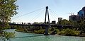 |
Connects Prince's Island Park with Sunnyside Sunnyside, Calgary Sunnyside is an innercity community in Calgary, Alberta located on the north side of the Bow River immediately adjacent to Calgary's downtown... , also crosses Memorial Drive Memorial Drive (Calgary) Memorial Drive is a major road in Calgary, Alberta. Besides having an important role in city infrastructure, the tree lined sides of Memorial Drive serve as a living testament to the many soldiers who died during World War I and give it a parkway look on the western section... |
||
| Jaipur Bridge | Pedestrian | 51.05432°N 114.06959°W | 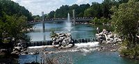 |
Connects Prince's Island Park with Eau Claire | ||
| Prince's Island Bridge East End | Pedestrian pathway | 51.05424°N 114.06742°W |  |
Connects eastern Prince's Island Park with Eau Claire and Chinatown Chinatown, Calgary Calgary's Chinatown is the fourth largest in Canada after those in Vancouver,Toronto, and Montreal. The size of Calgary's Chinatown is indicative of the relatively high proportion of people of Asian descent living in the city.... |
||
| Centre Street Bridge Centre Street Bridge (Calgary) The Centre Street Bridge is a bridge in Calgary, Alberta, crossing the Bow River, along the Centre Street. The lower deck connects Riverfront Avenue in Chinatown with Memorial Drive, while the upper elevated deck crosses Memorial Drive as well, reaching into the community of Crescent... |
Centre Street Centre Street (Calgary) Centre Street is a major road in Calgary, Alberta.The northern part extends from the Bow River to Bergen Road/Beddington Drive, after which it becomes a local arterial street before it becomes unavailable to private vehicular traffic north of Bergen Crescent... |
178 m | 1916 | 51.05291°N 114.06255°W | 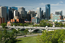 |
Connects Downtown Calgary Downtown Calgary Downtown Calgary is a region of central Calgary, Alberta. It is not a single neighbourhood per se, but is actually a larger community containing three neighbourhoods and a number of districts.... to Crescent Heights Crescent Heights, Calgary Crescent Heights is a neighbourhood in the northwest quadrant of Calgary, Alberta. It is located in the inner city, immediately north from Downtown... ; lower deck connects Chinatown Chinatown, Calgary Calgary's Chinatown is the fourth largest in Canada after those in Vancouver,Toronto, and Montreal. The size of Calgary's Chinatown is indicative of the relatively high proportion of people of Asian descent living in the city.... to Memorial Drive Memorial Drive (Calgary) Memorial Drive is a major road in Calgary, Alberta. Besides having an important role in city infrastructure, the tree lined sides of Memorial Drive serve as a living testament to the many soldiers who died during World War I and give it a parkway look on the western section... |
| 4th Avenue Flyover | 4th Avenue SE | 1972 | 51.05014°N 114.05265°W | Connects Memorial Drive Memorial Drive (Calgary) Memorial Drive is a major road in Calgary, Alberta. Besides having an important role in city infrastructure, the tree lined sides of Memorial Drive serve as a living testament to the many soldiers who died during World War I and give it a parkway look on the western section... to Downtown Calgary Downtown Calgary Downtown Calgary is a region of central Calgary, Alberta. It is not a single neighbourhood per se, but is actually a larger community containing three neighbourhoods and a number of districts.... |
||
| 5th Avenue Flyover | 5th Avenue SE | 51.04937°N 114.05098°W | Connects Downtown Calgary Downtown Calgary Downtown Calgary is a region of central Calgary, Alberta. It is not a single neighbourhood per se, but is actually a larger community containing three neighbourhoods and a number of districts.... to Memorial Drive Memorial Drive (Calgary) Memorial Drive is a major road in Calgary, Alberta. Besides having an important role in city infrastructure, the tree lined sides of Memorial Drive serve as a living testament to the many soldiers who died during World War I and give it a parkway look on the western section... , Crescent Heights Crescent Heights, Calgary Crescent Heights is a neighbourhood in the northwest quadrant of Calgary, Alberta. It is located in the inner city, immediately north from Downtown... and Bridgeland Bridgeland, Calgary The neighbourhood of Bridgeland of Calgary, Alberta, Canada, is located to the immediate northeast of downtown Calgary... . |
|||
| Langevin Bridge Langevin Bridge The Langevin Bridge is a bridge in Calgary, Alberta, Canada. It connects Downtown Calgary with north-central Calgary communities such as Bridgeland and Crescent Heights, by spanning the Bow River between 4th Avenue South and Memorial Drive.... |
Edmonton Trail Edmonton Trail Edmonton Trail is a major north-south arterial road in the north-east quadrant of Calgary, Alberta, Canada.The road connects Downtown Calgary from the Langevin Bridge and the 4th Street Bridge at Memorial Drive with north-central Calgary.... |
1910 | 51.04992°N 114.05230°W | Connects Bridgeland Bridgeland, Calgary The neighbourhood of Bridgeland of Calgary, Alberta, Canada, is located to the immediate northeast of downtown Calgary... to Downtown Calgary Downtown Calgary Downtown Calgary is a region of central Calgary, Alberta. It is not a single neighbourhood per se, but is actually a larger community containing three neighbourhoods and a number of districts.... ; south terminus of Edmonton Trail Edmonton Trail Edmonton Trail is a major north-south arterial road in the north-east quadrant of Calgary, Alberta, Canada.The road connects Downtown Calgary from the Langevin Bridge and the 4th Street Bridge at Memorial Drive with north-central Calgary.... ; named for Sir Hector Langevin |
||
| C-Train SE/Bridgeland Bridge | C-Train C-Train C-Train is the light rail transit system in Calgary, Alberta, Canada. It has been in operation since May 25, 1981. The system is operated by Calgary Transit, a department of the Calgary municipal government.-Operations:... Route 202 |
51.04928°N 114.05027°W | Between 3 Street SE 3 Street Southeast (C-Train) 3rd Street Southeast was a stop in downtown Calgary on the city's C-Train light rail system.The 3rd Street Southeast stop was only used by westbound Route 202 trains... and Bridgeland/Memorial Bridgeland/Memorial (C-Train) Bridgeland/Memorial is a stop on the Northeast Line of the C-Train light rail system in Calgary, Alberta. The station is located in the centre of Memorial Drive Northeast. It serves St. Patrick's Island, which is only a short walk away, as is the Calgary Zoo, although it is also accessible via the... stations |
|||
| St. Patrick's Island Bridge | Bow River pathway Bow River pathway The Bow River pathway is a pathway system developed along the banks of the Bow River in the city of Calgary. It contains a network of pedestrian and bicycle paths connecting parks on both sides of the river.... s |
51.04731°N 114.04629°W | Connects Downtown East Village, Fort Calgary Fort Calgary Fort Calgary was established in 1875 as Fort Brisebois by the North-West Mounted Police, located at the confluence of the Bow and Elbow rivers in what is now Calgary, Alberta.-History:... and Bow River pathways with St Patrick Island and Calgary Zoo Calgary Zoo The Calgary Zoo is located in Bridgeland, Calgary, Alberta, Canada, just east of the city's downtown and adjacent to the Inglewood and East Village neighbourhoods. It is accessible via Calgary's C-Train light rail system, by car via Memorial Drive and by bicycle and footpath via the Bow River... ; new project to cross to Bridgeland Bridgeland, Calgary The neighbourhood of Bridgeland of Calgary, Alberta, Canada, is located to the immediate northeast of downtown Calgary... |
|||
| Baines Bridge | Zoo Road | 51.04724°N 114.03624°W | 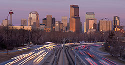 |
Connects Calgary Zoo Calgary Zoo The Calgary Zoo is located in Bridgeland, Calgary, Alberta, Canada, just east of the city's downtown and adjacent to the Inglewood and East Village neighbourhoods. It is accessible via Calgary's C-Train light rail system, by car via Memorial Drive and by bicycle and footpath via the Bow River... and Bridgeland Bridgeland, Calgary The neighbourhood of Bridgeland of Calgary, Alberta, Canada, is located to the immediate northeast of downtown Calgary... |
||
| Zoo Bridge (W) | Calgary Zoo Calgary Zoo The Calgary Zoo is located in Bridgeland, Calgary, Alberta, Canada, just east of the city's downtown and adjacent to the Inglewood and East Village neighbourhoods. It is accessible via Calgary's C-Train light rail system, by car via Memorial Drive and by bicycle and footpath via the Bow River... pathway |
51.04654°N 114.03090°W | Connects main Calgary Zoo Calgary Zoo The Calgary Zoo is located in Bridgeland, Calgary, Alberta, Canada, just east of the city's downtown and adjacent to the Inglewood and East Village neighbourhoods. It is accessible via Calgary's C-Train light rail system, by car via Memorial Drive and by bicycle and footpath via the Bow River... exhibits with the Prehistoric Park |
|||
| Zoo Bridge (E) | Calgary Zoo Calgary Zoo The Calgary Zoo is located in Bridgeland, Calgary, Alberta, Canada, just east of the city's downtown and adjacent to the Inglewood and East Village neighbourhoods. It is accessible via Calgary's C-Train light rail system, by car via Memorial Drive and by bicycle and footpath via the Bow River... pathway |
51.04578°N 114.02798°W | Connects main Calgary Zoo Calgary Zoo The Calgary Zoo is located in Bridgeland, Calgary, Alberta, Canada, just east of the city's downtown and adjacent to the Inglewood and East Village neighbourhoods. It is accessible via Calgary's C-Train light rail system, by car via Memorial Drive and by bicycle and footpath via the Bow River... exhibits with the Canadian Wilds |
|||
| St. Georges Zoo Bridge | 12 St SE | 51.04339°N 114.03219°W | Connects Calgary Zoo Calgary Zoo The Calgary Zoo is located in Bridgeland, Calgary, Alberta, Canada, just east of the city's downtown and adjacent to the Inglewood and East Village neighbourhoods. It is accessible via Calgary's C-Train light rail system, by car via Memorial Drive and by bicycle and footpath via the Bow River... with Inglewood |
|||
| Canadian Pacific Bridge (Nose Creek) | Canadian Pacific Railway Canadian Pacific Railway The Canadian Pacific Railway , formerly also known as CP Rail between 1968 and 1996, is a historic Canadian Class I railway founded in 1881 and now operated by Canadian Pacific Railway Limited, which began operations as legal owner in a corporate restructuring in 2001... |
51.04440°N 114.01879°W | 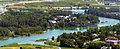 |
Railroad bridge | ||
Bow River (south of downtown)
| Bridge | Carries | Length | Built | Coordinates | Image | Remarks |
|---|---|---|---|---|---|---|
| Cushing Bridge | Blackfoot Trail SE / International Avenue International Avenue, Calgary International Avenue is a Business Revitalization Zone in Calgary, Alberta. The district is centered on 17th Avenue S.E. in the neighbourhood of Forest Lawn in the east of the city. The district was created in 1993 to celebrate the rich cultural diversity that exists in east central Calgary... |
51.03736°N 114.01280°W | Connects Inglewood with Forest Lawn; named after William Henry Cushing William Henry Cushing William Henry Cushing was a Canadian politician. Born in Ontario, he migrated west as a young adult where he started a successful lumber company and later became Alberta's first Minister of Public Works and the 11th mayor of Calgary... , Calgary mayor from 1900 to 1901 |
|||
| Canadian Pacific Bridge (Alyth) | Canadian Pacific Railway Canadian Pacific Railway The Canadian Pacific Railway , formerly also known as CP Rail between 1968 and 1996, is a historic Canadian Class I railway founded in 1881 and now operated by Canadian Pacific Railway Limited, which began operations as legal owner in a corporate restructuring in 2001... |
51.01452°N 114.01148°W | Railroad bridge, connects main tracks with CPR Alyth Yard CPR Alyth Yard CPR Alyth Yard is a Class 1 railway facility located in the neighbourhood of Alyth, southeast of downtown Calgary, Alberta. One of Canadian Pacific Railway's main marshalling yards in Canada, it primarily serves as a hump classification yard and in addition has rail car repair shops and diesel... |
|||
| Bonnybrook Bridge | Ogden Road SE | 51.01290°N 114.01284°W | Connects Alyth with Foothills Industrial Park | |||
| Calf Robe Bridge | Deerfoot Trail Deerfoot Trail Deerfoot Trail is a freeway section of the Queen Elizabeth II Highway in Calgary, Alberta, Canada. It was formerly known as Blackfoot Trail Freeway, but was renamed to honour the first Native American to win the marathon.... |
51.00856°N 114.01869°W | Connects Deerfoot trail from Glenmore Trail to Paigan Road; named after Ben Calf Robe, a Siksika Siksika Nation The Siksika Nation is a First Nation in southern Alberta, Canada. The name Siksiká comes from the Blackfoot words sik and iká , with a connector s between the two words. The plural form of Siksiká is Siksikáwa... chief |
|||
| Canadian National Bridge | CN Railway Canadian National Railway The Canadian National Railway Company is a Canadian Class I railway headquartered in Montreal, Quebec. CN's slogan is "North America's Railroad".... |
51.00437°N 114.02195°W | Connects Canadian Pacific Railway Canadian Pacific Railway The Canadian Pacific Railway , formerly also known as CP Rail between 1968 and 1996, is a historic Canadian Class I railway founded in 1881 and now operated by Canadian Pacific Railway Limited, which began operations as legal owner in a corporate restructuring in 2001... to Canadian National Railway Canadian National Railway The Canadian National Railway Company is a Canadian Class I railway headquartered in Montreal, Quebec. CN's slogan is "North America's Railroad".... |
|||
| Graves Bridge | Glenmore Trail | 50.98658°N 114.02466°W | Connects Alyth to Riverbend and Ogden, leads to Highway 8 east; twinned in 2009 | |||
| Southland Pedestrian Bridge | Pedestrian | 50.96957°N 114.02575°W | Connects Southland Drive and Acadia to Riverbend | |||
| Lafarge Bridge | Road | 50.95651°N 114.02295°W | Connects Lafarge Lafarge Lafarge is a French industrial company specialising in four major products: cement, construction aggregates, concrete and gypsum wallboard. In 2010 the company was the world's second-largest cement manufacturer by mass shipped behind Holcim.-History:... cement plant to Douglasglen |
|||
| Ivor Strong Bridge | Deerfoot Trail Deerfoot Trail Deerfoot Trail is a freeway section of the Queen Elizabeth II Highway in Calgary, Alberta, Canada. It was formerly known as Blackfoot Trail Freeway, but was renamed to honour the first Native American to win the marathon.... |
50.95259°N 114.02058°W | Connects Maple Ridge to Douglasdale at the Anderson Road alignment; named after John Ivor Strong, Chief Commissioner for the City of Calgary from 1965 to 1971 | |||
| Douglasdale Park Pedestrian Bridge | Pedestrian | 50.94090°N 114.01109°W | Connects Douglasdale Park to Queensland | |||
| McKenzie Pedestrian Bridge | Pedestrian | 50.91178°N 113.99827°W | Connects Deer Ridge with McKenzie Lake | |||
| Marquis de Lorne Bridge | Highway 22X | 2009 | 50.89435°N 114.00937°W | Connects Marquis de Lorne Trail m from Sundance Sundance, Calgary Sundance is a residential neighbourhood in the south-east quadrant of Calgary, Alberta. It is located east of Macleod Trail, is bounded to the north-east by the Fish Creek Provincial Park and to the south by Marquis of Lorne Trail... and Chaparral across Fish Creek Provincial Park Fish Creek Provincial Park Fish Creek Park is a provincial park located in the southern part of Calgary, Alberta, Canada. It is one of the largest urban parks in North America, stretching from east to west. At , it is over three times the size of Vancouver's Stanley Park.... to McKenzie Lake and Cranston |
||
| Dunbow Road Bridge | Highway 2 | 50.85420°N 113.97095°W | Connects Deerfoot Trail Deerfoot Trail Deerfoot Trail is a freeway section of the Queen Elizabeth II Highway in Calgary, Alberta, Canada. It was formerly known as Blackfoot Trail Freeway, but was renamed to honour the first Native American to win the marathon.... to Macleod Trail south of Calgary, between Auburn Bay Auburn Bay, Calgary Auburn Bay is a new suburban residential neighbourhood in the south-east quadrant of Calgary, Alberta. It is located at the south-eastern edge of the city, and is bounded by Seton Boulevard to the south, Deerfoot Trail to the west, the yet-to-be-constructed 52 Street E extension to the east and... and Heritage Pointe Heritage Pointe, Alberta Heritage Pointe is a hamlet located in Alberta, Canada within the Municipal District of Foothills No. 31. It is located north of Dunbow Road, between Highway 2 and Highway 2A , adjacent to the southern boundary of Calgary.... |
|||
Elbow River
The Elbow RiverElbow River
The Elbow River is a river located in southern Alberta, Canada. It flows from the Canadian Rockies to the city of Calgary, where it merges into the Bow River....
enters the city in the south-west, then turns north and merges into the Bow River immediately east of downtown. From west to north, the following structures cross the river.
| Bridge | Carries | Length | Built | Coordinates | Image | Remarks |
|---|---|---|---|---|---|---|
| Highway 8 Bridge | Highway 8 | 51.01693°N 114.24017°W | Highway 8 named Glenmore Trail east of this point | |||
| Weaselhead Road Bridge | Weasel Head Road | 50.99497°N 114.16535°W | Bridge for road traffic, inside the limits of the Tsuu T'ina Nation Tsuu T'ina Nation 145, Alberta Tsuu T'ina Nation 145 is the name of an Indian reserve in southern Alberta, Canada. It is the home of the Tsuu T'ina Nation. The reserve was created by Treaty 7. Reserve lands are between Southwest Calgary, Alberta in the east and Bragg Creek, Alberta in the west. The north boundary is just... reserve |
|||
| Weaselhead Pedestrian Bridge | Pedestrian | 50°59′29"N 114°8′48"W | Bridge just west of Weaslehead Natural Area, inside the limits of Tsuu T'ina Nation Tsuu T'ina Nation 145, Alberta Tsuu T'ina Nation 145 is the name of an Indian reserve in southern Alberta, Canada. It is the home of the Tsuu T'ina Nation. The reserve was created by Treaty 7. Reserve lands are between Southwest Calgary, Alberta in the east and Bragg Creek, Alberta in the west. The north boundary is just... reserve |
|||
| Glenmore Trail bridge | Glenmore Trail | 50.99530°N 114.09928°W |  |
Crosses the Glenmore Reservoir Glenmore Reservoir The Glenmore Reservoir is a large artificial reservoir on the Elbow River in the southwest quadrant of Calgary, Alberta. The Glenmore Dam is the concrete structure that holds back the reservoir. The reservoir is a primary source of drinking water to the city... |
||
| Glenmore Dam | Pedestrian, maintenance road | 1933 | 50.99990°N 114.09715°W | Dam, created Glenmore Reservoir, allows pedestrian access and maintenance vehicles (no public vehicle access) along Glenmore Bridge Rd. | ||
| Altadore Park Bridge | Pedestrian | 51.01199°N 114.09182°W | Connects Altadore Park (in Altadore) and Riverdale Park (in Britannia Britannia, Calgary Britannia is a residential neighbourhood in the south-west quadrant of Calgary, Alberta, Canada. It is bounded by Elbow Drive to the east, 50 Avenue S to the south, Elbow River and Riverdale Park to the west and Britannia Drive to the north.... ) |
|||
| Elbow Park Britannia Pedestrian Bridge | Pedestrian | 51.01887°N 114.08317°W | Connects Elbow River bike and pathway; between Elbow Park and Britannia Britannia, Calgary Britannia is a residential neighbourhood in the south-west quadrant of Calgary, Alberta, Canada. It is bounded by Elbow Drive to the east, 50 Avenue S to the south, Elbow River and Riverdale Park to the west and Britannia Drive to the north.... |
|||
| Elbow Drive Bridge | Elbow Drive | 51.01786°N 114.07788°W | Connects the neighbourhoods of Elbow Park and Britannia Britannia, Calgary Britannia is a residential neighbourhood in the south-west quadrant of Calgary, Alberta, Canada. It is bounded by Elbow Drive to the east, 50 Avenue S to the south, Elbow River and Riverdale Park to the west and Britannia Drive to the north.... |
|||
| Elbow Park Roxboro Pedestrian Bridge | Pedestrian | 51.02495°N 114.07779°W | Connects Elbow River bike and pathway; between Elbow Park and Roxboro | |||
| 4 St SW Bridge | 4 Street SW | 51.02934°N 114.07152°W | Connects the neighbourhoods of Mission Mission, Calgary The Mission district is an inner city neighbourhood of Calgary, Alberta, Canada that originated as Notre Dame de la Paix, a Catholic mission, and was for a time the incorporated Village of Rouleauville... and Roxboro |
|||
| Scollen Bridge | 25 Avenue SW | 51.03041°N 114.06343°W | Connects the neighbourhoods of Mission Mission, Calgary The Mission district is an inner city neighbourhood of Calgary, Alberta, Canada that originated as Notre Dame de la Paix, a Catholic mission, and was for a time the incorporated Village of Rouleauville... and Erlton |
|||
| 21 Ave SW Talisman Pedestrian Bridge | Pedestrian | 51.03421°N 114.06751°W | Between 21 Ave SW and the Talisman Centre Talisman Centre The Talisman Centre, formerly known as the Lindsay Park Sports Centre, is a multi-sports complex in Calgary, Alberta, Canada. The name of the facility was changed in March 2002, after the City of Calgary sold the naming rights for 10 million dollars to Talisman Energy for 30 years.The complex... grounds |
|||
| 19 Ave SW Talisman Pedestrian Bridge | Pedestrian | 51.03588°N 114.06538°W | Between 19 Ave SW (behind St. Mary's Cathedral and the Talisman Centre Talisman Centre The Talisman Centre, formerly known as the Lindsay Park Sports Centre, is a multi-sports complex in Calgary, Alberta, Canada. The name of the facility was changed in March 2002, after the City of Calgary sold the naming rights for 10 million dollars to Talisman Energy for 30 years.The complex... grounds |
|||
| Pattison Bridge | Macleod Trail South | 51.03600°N 114.06126°W | Between Mission Mission, Calgary The Mission district is an inner city neighbourhood of Calgary, Alberta, Canada that originated as Notre Dame de la Paix, a Catholic mission, and was for a time the incorporated Village of Rouleauville... and Talisman Centre Talisman Centre The Talisman Centre, formerly known as the Lindsay Park Sports Centre, is a multi-sports complex in Calgary, Alberta, Canada. The name of the facility was changed in March 2002, after the City of Calgary sold the naming rights for 10 million dollars to Talisman Energy for 30 years.The complex... , named for John George Pattison John George Pattison John George Pattison VC , was a Canadian recipient of the Victoria Cross, the highest and most prestigious award for gallantry in the face of the enemy that can be awarded to British and Commonwealth forces.-Details:... , Victoria Cross Victoria Cross The Victoria Cross is the highest military decoration awarded for valour "in the face of the enemy" to members of the armed forces of various Commonwealth countries, and previous British Empire territories.... recipient of the 50th Battalion, CEF Canadian Expeditionary Force The Canadian Expeditionary Force was the designation of the field force created by Canada for service overseas in the First World War. Units of the C.E.F. were divided into field formation in France, where they were organized first into separate divisions and later joined together into a single... . |
|||
| Victoria Bridge | Macleod Trail North | 51.03448°N 114.05911°W | Between Mission Mission, Calgary The Mission district is an inner city neighbourhood of Calgary, Alberta, Canada that originated as Notre Dame de la Paix, a Catholic mission, and was for a time the incorporated Village of Rouleauville... and Talisman Centre Talisman Centre The Talisman Centre, formerly known as the Lindsay Park Sports Centre, is a multi-sports complex in Calgary, Alberta, Canada. The name of the facility was changed in March 2002, after the City of Calgary sold the naming rights for 10 million dollars to Talisman Energy for 30 years.The complex... |
|||
| Macleod Train Bridge | C-Train C-Train C-Train is the light rail transit system in Calgary, Alberta, Canada. It has been in operation since May 25, 1981. The system is operated by Calgary Transit, a department of the Calgary municipal government.-Operations:... |
51°2′2"N 114°3′32"W | Between Mission Mission, Calgary The Mission district is an inner city neighbourhood of Calgary, Alberta, Canada that originated as Notre Dame de la Paix, a Catholic mission, and was for a time the incorporated Village of Rouleauville... and Talisman Centre Talisman Centre The Talisman Centre, formerly known as the Lindsay Park Sports Centre, is a multi-sports complex in Calgary, Alberta, Canada. The name of the facility was changed in March 2002, after the City of Calgary sold the naming rights for 10 million dollars to Talisman Energy for 30 years.The complex... |
|||
| Stampede Trail Bridge | Stampede Trail SE | 51.03265°N 114.05675°W | Provides entry into the Calgary Stampede Calgary Stampede The Calgary Stampede is an annual rodeo, exhibition and festival held every July in Calgary, Alberta, Canada. The ten-day event, which bills itself as "The Greatest Outdoor Show on Earth", attracts over one million visitors per year and features one of the world's largest rodeos, a parade, midway,... grounds and access to the Stampede Grandstand Stampede Grandstand The Stampede Grandstand is a 17,000-seat, plus 8,000 more with standing room, stadium in Calgary, Alberta, Canada. It annually hosts the rodeo, the chuckwagon races and the evening Grandstand Show portions of the Calgary Stampede.... |
|||
| Stampede Ground Bridge | maintenance road | 51°1′52"N 114°3′2"W | Provides acceess Calgary Stampede Calgary Stampede The Calgary Stampede is an annual rodeo, exhibition and festival held every July in Calgary, Alberta, Canada. The ten-day event, which bills itself as "The Greatest Outdoor Show on Earth", attracts over one million visitors per year and features one of the world's largest rodeos, a parade, midway,... ground buildings |
|||
| Stampede Ground Bridge | maintenance road | 51°1′53"N 114°3′1"W | Provides acceess Calgary Stampede Calgary Stampede The Calgary Stampede is an annual rodeo, exhibition and festival held every July in Calgary, Alberta, Canada. The ten-day event, which bills itself as "The Greatest Outdoor Show on Earth", attracts over one million visitors per year and features one of the world's largest rodeos, a parade, midway,... ground buildings |
|||
| Saddledome Trail Bridge | Pedestrian | 51°2′13"N 114°2′59"W | Provides entry into the Calgary Stampede Calgary Stampede The Calgary Stampede is an annual rodeo, exhibition and festival held every July in Calgary, Alberta, Canada. The ten-day event, which bills itself as "The Greatest Outdoor Show on Earth", attracts over one million visitors per year and features one of the world's largest rodeos, a parade, midway,... grounds and access to the Scotiabank Saddledome |
|||
| Agriculture Trail Bridge | Agriculture Trail SE | 51.03858°N 114.04873°W | Service road from Calgary Stampede Calgary Stampede The Calgary Stampede is an annual rodeo, exhibition and festival held every July in Calgary, Alberta, Canada. The ten-day event, which bills itself as "The Greatest Outdoor Show on Earth", attracts over one million visitors per year and features one of the world's largest rodeos, a parade, midway,... grounds |
|||
| Macdonald Avenue Bridge | Macdonald Avenue SE | 51.04132°N 114.04474°W | Connects the neighbourhoods of Victoria Park and Ramsay | |||
| Canadian Pacific Rail Bridge (Inglewood) | Canadian Pacific Railway Canadian Pacific Railway The Canadian Pacific Railway , formerly also known as CP Rail between 1968 and 1996, is a historic Canadian Class I railway founded in 1881 and now operated by Canadian Pacific Railway Limited, which began operations as legal owner in a corporate restructuring in 2001... |
51.04318°N 114.04287°W | 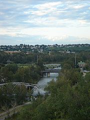 |
Connects the Canadian Pacific Railway Canadian Pacific Railway The Canadian Pacific Railway , formerly also known as CP Rail between 1968 and 1996, is a historic Canadian Class I railway founded in 1881 and now operated by Canadian Pacific Railway Limited, which began operations as legal owner in a corporate restructuring in 2001... downtown yard with the CPR Alyth Yard CPR Alyth Yard CPR Alyth Yard is a Class 1 railway facility located in the neighbourhood of Alyth, southeast of downtown Calgary, Alberta. One of Canadian Pacific Railway's main marshalling yards in Canada, it primarily serves as a hump classification yard and in addition has rail car repair shops and diesel... |
||
| Inglewood Bridge | 9 Avenue SE | 51.04366°N 114.04274°W | 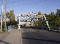 |
Connects Downtown East Village to Inglewood | ||
Fish Creek
Fish Creek flows from west to east in the south part of the city, through the Fish Creek Provincial ParkFish Creek Provincial Park
Fish Creek Park is a provincial park located in the southern part of Calgary, Alberta, Canada. It is one of the largest urban parks in North America, stretching from east to west. At , it is over three times the size of Vancouver's Stanley Park....
. It merges into the Bow River
Bow River
The Bow River is a river in the Canadian province of Alberta. It is a tributary of the South Saskatchewan River, and is considered the headwater of the Nelson River....
in the South-East quadrant of the city.
| Bridge | Carries | Length | Built | Coordinates | Image | Remarks |
|---|---|---|---|---|---|---|
| 37 St SW Bridge | 37 St SW | 50.92781°N 114.14005°W | Connects the neighbourhoods of Woodbine and Evergreen | |||
| Fish Creek Pedestrian Bridge no. 1 | Pathway | 50.92875°N 114.13728°W | Connects pathways in the Fish Creek Provincial Park Fish Creek Provincial Park Fish Creek Park is a provincial park located in the southern part of Calgary, Alberta, Canada. It is one of the largest urban parks in North America, stretching from east to west. At , it is over three times the size of Vancouver's Stanley Park.... |
|||
| Fish Creek Pedestrian Bridge no. 2 | Pathway | 50.92765°N 114.12604°W | Connects pathways in the Fish Creek Provincial Park Fish Creek Provincial Park Fish Creek Park is a provincial park located in the southern part of Calgary, Alberta, Canada. It is one of the largest urban parks in North America, stretching from east to west. At , it is over three times the size of Vancouver's Stanley Park.... |
|||
| Fish Creek Pedestrian Bridge no. 3 | Pathway | 50.92641°N 114.10975°W | Connects pathways in the Fish Creek Provincial Park Fish Creek Provincial Park Fish Creek Park is a provincial park located in the southern part of Calgary, Alberta, Canada. It is one of the largest urban parks in North America, stretching from east to west. At , it is over three times the size of Vancouver's Stanley Park.... |
|||
| Fish Creek Pedestrian Bridge no. 4 | Pathway | 50.93133°N 114.10870°W | Connects pathways in the Fish Creek Provincial Park Fish Creek Provincial Park Fish Creek Park is a provincial park located in the southern part of Calgary, Alberta, Canada. It is one of the largest urban parks in North America, stretching from east to west. At , it is over three times the size of Vancouver's Stanley Park.... |
|||
| Fish Creek Pedestrian Bridge no. 5 | Pathway | 50.93297°N 114.10521°W |  |
Connects pathways in the Fish Creek Provincial Park Fish Creek Provincial Park Fish Creek Park is a provincial park located in the southern part of Calgary, Alberta, Canada. It is one of the largest urban parks in North America, stretching from east to west. At , it is over three times the size of Vancouver's Stanley Park.... |
||
| Fish Creek Pedestrian Bridge no. 6 | Pathway | 50.93405°N 114.10411°W | Connects pathways in the Fish Creek Provincial Park Fish Creek Provincial Park Fish Creek Park is a provincial park located in the southern part of Calgary, Alberta, Canada. It is one of the largest urban parks in North America, stretching from east to west. At , it is over three times the size of Vancouver's Stanley Park.... |
|||
| Fish Creek Pedestrian Bridge no. 7 | Pathway | 50.93400°N 114.09750°W | Connects pathways in the Fish Creek Provincial Park Fish Creek Provincial Park Fish Creek Park is a provincial park located in the southern part of Calgary, Alberta, Canada. It is one of the largest urban parks in North America, stretching from east to west. At , it is over three times the size of Vancouver's Stanley Park.... |
|||
| CPR Bridge (Fish Creek) | Canadian Pacific Railway Canadian Pacific Railway The Canadian Pacific Railway , formerly also known as CP Rail between 1968 and 1996, is a historic Canadian Class I railway founded in 1881 and now operated by Canadian Pacific Railway Limited, which began operations as legal owner in a corporate restructuring in 2001... |
50.92914°N 114.07238°W | Also carriers C-Train C-Train C-Train is the light rail transit system in Calgary, Alberta, Canada. It has been in operation since May 25, 1981. The system is operated by Calgary Transit, a department of the Calgary municipal government.-Operations:... tracks |
|||
| Macleod Trail Bridge | Macleod Trail | 50.92895°N 114.06979°W | Connects the neighbourhoods of Canyon Meadows and Lake Bonavista to Shawnee Slopes and Midnapore | |||
| Bow Bottom Bridge | Bow Bottom Trail SW | 50.90714°N 114.01492°W | Connects the neighbourhoods of Deer Run and Parkland to Sikome Lake Sikome Lake The Sikome Aquatic Facility, commonly referred to as Sikome Lake, is a man made lake in the city of Calgary, Alberta, Canada. It is located in the south-east quadrant of the city, within the Fish Creek Provincial Park, and is part of the Bow River basin... and Fish Creek Provincial Park Fish Creek Provincial Park Fish Creek Park is a provincial park located in the southern part of Calgary, Alberta, Canada. It is one of the largest urban parks in North America, stretching from east to west. At , it is over three times the size of Vancouver's Stanley Park.... |
|||