

List of Registered Historic Places in Marion County, Oregon
Encyclopedia
National Register of Historic Places
The National Register of Historic Places is the United States government's official list of districts, sites, buildings, structures, and objects deemed worthy of preservation...
(NRHP) recognizes buildings, structures, objects, sites, and districts of national, state, or local historic significance across the United States
United States
The United States of America is a federal constitutional republic comprising fifty states and a federal district...
. Out of over 80,000 NRHP sites nationwide, Oregon
Oregon
Oregon is a state in the Pacific Northwest region of the United States. It is located on the Pacific coast, with Washington to the north, California to the south, Nevada on the southeast and Idaho to the east. The Columbia and Snake rivers delineate much of Oregon's northern and eastern...
is home to approximately 1,900, and 106 of those are found in Marion County
Marion County, Oregon
Marion County is a county located in the U.S. state of Oregon. It was originally named the Champooick District, after Champoeg, a meeting place on the Willamette River. On September 3, 1849, the territorial legislature renamed it in honor of Francis Marion, a Continental Army general of the...
. At least three other Marion County sites that were once listed have been removed from the Register.
Current listings
| Site name | Image | Date listed | Location | City or Town | Summary | |
|---|---|---|---|---|---|---|
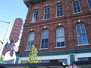
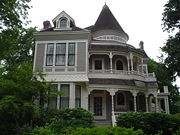
| 1 | Louis J. Adams House | image pending | 423 W. Main St. 45°0′11"N 122°47′13"W |
Silverton Silverton, Oregon Silverton is a city in Marion County, Oregon, United States, along the 45th parallel. The population was 7,414 at the 2000 census. It is part of the Salem Metropolitan Statistical Area.-Geography:... |
Silverton, Oregon, and Its Environs MPS | |
| 2 | Adolph Block Adolph Block The Adolph Block, located in Salem, Oregon, is listed on the National Register of Historic Places.... |
360–372 State Street NE 44.94013°N 123.0393°W |
Salem Salem, Oregon Salem is the capital of the U.S. state of Oregon, and the county seat of Marion County. It is located in the center of the Willamette Valley alongside the Willamette River, which runs north through the city. The river forms the boundary between Marion and Polk counties, and the city neighborhood... |
|||
| 3 | Samuel Adolph House | 2493 State Street 44.9326°N 123.0103°W |
Salem Salem, Oregon Salem is the capital of the U.S. state of Oregon, and the county seat of Marion County. It is located in the center of the Willamette Valley alongside the Willamette River, which runs north through the city. The river forms the boundary between Marion and Polk counties, and the city neighborhood... |
|||
| 4 | James Mechlin Anderson House | image pending | 728 Ankeny Hill Road 44.7767°N 123.0462°W |
Jefferson Jefferson, Oregon Jefferson is a city in Marion County, Oregon, United States. It is part of the Salem Metropolitan Statistical Area. The population was 2,487 at the 2000 census... |
||
| 5 | Aurora Colony Historic District | District roughly bounded by Cemetery Road, Bobs Avenue, and Liberty Street 45.23258°N 122.7584°W (approx.) |
Aurora Aurora, Oregon Aurora is a city in Marion County, Oregon, United States. It was founded as a religious commune in 1856 by Dr. William Keil who named the settlement after his daughter. The population was 918 at the 2010 census... |
|||
| 6 | Bank of Woodburn | 199 N Front Street 45.14181°N 122.8574°W |
Woodburn Woodburn, Oregon Woodburn is a city in Marion County, Oregon, United States. Incorporated in 1889, the community had been platted in 1871 after the arrival of the railroad. The city is located in the northern end of the Willamette Valley along Interstate 5 between Portland and Salem... |
|||
| 7 | Oliver Beers House | image pending | 10602 Wheatland Road, N 45.07305°N 123.0232°W |
Gervais Gervais, Oregon Gervais is a city in Marion County, Oregon, United States. The population was 2,009 at the 2000 census. The 2007 estimate is 2,250 residents. It is part of the Salem Metropolitan Statistical Area.-History:... vicinity |
||
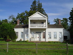
| 8 | Frederick Bents House | 22776 Bents Road, NE 45.24829°N 122.8111°W |
Aurora Aurora, Oregon Aurora is a city in Marion County, Oregon, United States. It was founded as a religious commune in 1856 by Dr. William Keil who named the settlement after his daughter. The population was 918 at the 2010 census... vicinity |
Originally built in 1887, this French Prairie French Prairie French Prairie is a prairie located in Marion County, Oregon, United States, in the Willamette Valley between the Willamette River and the Pudding River, north of Salem... farmhouse expanded several times over subsequent years, resulting in an unusual admixture of multiple 19th-century architectural styles. It reflects the changing requirements of farm life and economics over a long period in this portion of the Willamette Valley Willamette Valley The Willamette Valley is the most populated region in the state of Oregon of the United States. Located in the state's northwest, the region is surrounded by tall mountain ranges to the east, west and south and the valley's floor is broad, flat and fertile because of Ice Age conditions... . |
||
| 9 | R.P. Boise Building | 217 State Street 44.9406°N 123.0411°W |
Salem Salem, Oregon Salem is the capital of the U.S. state of Oregon, and the county seat of Marion County. It is located in the center of the Willamette Valley alongside the Willamette River, which runs north through the city. The river forms the boundary between Marion and Polk counties, and the city neighborhood... |
|||
| 10 | Boon Brick Store Boon Brick Store The Boon Brick Store is a historic building in Salem, Oregon, United States. It was built as a general store by John D. Boon who became the first Oregon State Treasurer. It also once served as Oregon's first State Treasury. It is now a brewpub owned by the McMenamins chain known as Boon's Treasury... |
888 Liberty Street, NE 44.94859°N 123.033°W |
Salem Salem, Oregon Salem is the capital of the U.S. state of Oregon, and the county seat of Marion County. It is located in the center of the Willamette Valley alongside the Willamette River, which runs north through the city. The river forms the boundary between Marion and Polk counties, and the city neighborhood... |
|||
| 11 | John D. Boon House | 1313 Mill Street, SE 44.93382°N 123.0275°W |
Salem Salem, Oregon Salem is the capital of the U.S. state of Oregon, and the county seat of Marion County. It is located in the center of the Willamette Valley alongside the Willamette River, which runs north through the city. The river forms the boundary between Marion and Polk counties, and the city neighborhood... |
Included in the Mission Mill Museum Mission Mill Museum Mission Mill Museum is a historic museum located in Salem, Oregon, United States. It features working displays of a woolen mill—the Thomas Kay Woolen Mill—and several historic Salem buildings that have been relocated to the mill site.-Mill history:... . |
||
| 12 | Charles and Martha Brown House | image pending | 425 N First Avenue 44.798°N 122.7944°W |
Stayton Stayton, Oregon Stayton is a city in Marion County, Oregon, United States, located southeast of the state capital, Salem, on Oregon Route 22. It is south of Sublimity and east of Aumsville. Located on the North Santiam River, Stayton is a regional agricultural and light manufacturing center. The population was... |
||
| 13 | Sam Brown House Sam Brown House Sam Brown House is a historic house in Gervais, Oregon, United States built in 1857 by Oregon pioneer and state senator Samuel Brown... |
 |
12878 Portland Road, NE 45.10576°N 122.8868°W |
Gervais Gervais, Oregon Gervais is a city in Marion County, Oregon, United States. The population was 2,009 at the 2000 census. The 2007 estimate is 2,250 residents. It is part of the Salem Metropolitan Statistical Area.-History:... |
||
| 14 | Burggraf–Burt–Webster House | 901 13th Street, SE 44.92868°N 123.0293°W |
Salem Salem, Oregon Salem is the capital of the U.S. state of Oregon, and the county seat of Marion County. It is located in the center of the Willamette Valley alongside the Willamette River, which runs north through the city. The river forms the boundary between Marion and Polk counties, and the city neighborhood... |
|||
| 15 | Bush and Brey Block and Annex | 179–197 Commercial Street, NE 44.94153°N 123.0402°W |
Salem Salem, Oregon Salem is the capital of the U.S. state of Oregon, and the county seat of Marion County. It is located in the center of the Willamette Valley alongside the Willamette River, which runs north through the city. The river forms the boundary between Marion and Polk counties, and the city neighborhood... |
|||
| 16 | Asahel Bush House | 600 Mission Street, SE 44.93216°N 123.0388°W |
Salem Salem, Oregon Salem is the capital of the U.S. state of Oregon, and the county seat of Marion County. It is located in the center of the Willamette Valley alongside the Willamette River, which runs north through the city. The river forms the boundary between Marion and Polk counties, and the city neighborhood... |
|||
| 17 | Bush–Breyman Block | 141–147 Commercial Street, NE 44.94117°N 123.0404°W |
Salem Salem, Oregon Salem is the capital of the U.S. state of Oregon, and the county seat of Marion County. It is located in the center of the Willamette Valley alongside the Willamette River, which runs north through the city. The river forms the boundary between Marion and Polk counties, and the city neighborhood... |
|||
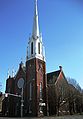
| 18 | Calvary Lutheran Church and Parsonage Calvary Lutheran Church and Parsonage (Silverton, Oregon) Calvary Lutheran Church and Parsonage is a historic church building and parsonage in Silverton, Oregon, United States. The church is also known as the First Christian Church. The church is a combination of the Carpenter Gothic and the Queen Anne architectural styles... |
 |
310–314 Jersey Street 45.0045°N 122.781°W |
Silverton Silverton, Oregon Silverton is a city in Marion County, Oregon, United States, along the 45th parallel. The population was 7,414 at the 2000 census. It is part of the Salem Metropolitan Statistical Area.-Geography:... |
||
| 19 | Hamilton Campbell House | image pending | Route 1 44.76031°N 123.0281°W |
Jefferson Jefferson, Oregon Jefferson is a city in Marion County, Oregon, United States. It is part of the Salem Metropolitan Statistical Area. The population was 2,487 at the 2000 census... vicinity |
||
| 20 | William Case Farm | 20755 Case Road, NE 45.2226°N 122.8804°W |
Aurora Aurora, Oregon Aurora is a city in Marion County, Oregon, United States. It was founded as a religious commune in 1856 by Dr. William Keil who named the settlement after his daughter. The population was 918 at the 2010 census... |
|||
| 21 | Champoeg Cemetery | Champoeg Cemetery Road 45.23898°N 122.8762°W |
Aurora Aurora, Oregon Aurora is a city in Marion County, Oregon, United States. It was founded as a religious commune in 1856 by Dr. William Keil who named the settlement after his daughter. The population was 918 at the 2010 census... |
|||
| 22 | Champoeg State Park Historic Archeological District Champoeg, Oregon Champoeg is a former town in the U.S. state of Oregon. Now a ghost town, it was an important settlement in the Willamette Valley in the early 1840s. It is positioned halfway between Oregon City and Salem and the site of the first provisional government of the Oregon Country... |
 |
8239 Champoeg Road, NE 45°14′53.67"N 122°53′37.09"W |
St. Paul St. Paul, Oregon St. Paul is a city in Marion County, Oregon, United States. It is named after the Saint Paul Mission founded by Archbishop François Norbert Blanchet, who arrived in the Oregon Territory in 1838 to minister to the Catholic inhabitants of French Prairie. The population was 354 at the 2000 census... |
||
| 23 | Chemawa Indian School Site Chemawa Indian School Chemawa Indian School is a Native American boarding school in Salem, Oregon, United States. It was opened on February 25, 1880 as an elementary school, but as of 2005, served ninth through twelfth grades. It is sometimes referred to as Chemawa High School... |
3700 Chemawa Road, NE 45.00118°N 122.9951°W |
Chemawa Chemawa, Oregon Chemawa was an unincorporated community north of Salem, Oregon, United States. Chemawa was also the name of a station on the Southern Pacific railroad. Chemawa Indian School was named after the Chemawa post office at this locale.... |
|||
| 24 | Chemeketa Lodge No. 1 Odd Fellows Buildings Grand Theater (Salem, Oregon) The Grand Theater is part of a complex of historic buildings in Salem, Oregon, United States that was originally owned by the fraternal organization Independent Order of Odd Fellows, and listed on the National Register of Historic Places as the Chemeketa Lodge No. 1, Odd Fellows Buildings. The... |
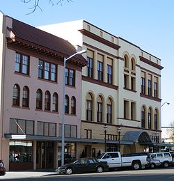 |
185–195 High Street, NE 44.94072°N 123.0371°W |
Salem Salem, Oregon Salem is the capital of the U.S. state of Oregon, and the county seat of Marion County. It is located in the center of the Willamette Valley alongside the Willamette River, which runs north through the city. The river forms the boundary between Marion and Polk counties, and the city neighborhood... |
||
| 25 | George Collins House | 1340 Chemeketa Street, NE 44.93872°N 123.0241°W |
Salem Salem, Oregon Salem is the capital of the U.S. state of Oregon, and the county seat of Marion County. It is located in the center of the Willamette Valley alongside the Willamette River, which runs north through the city. The river forms the boundary between Marion and Polk counties, and the city neighborhood... |
|||
| 26 | Jacob Conser House | image pending | 114 Main Street 44.7179°N 123.0117°W |
Jefferson Jefferson, Oregon Jefferson is a city in Marion County, Oregon, United States. It is part of the Salem Metropolitan Statistical Area. The population was 2,487 at the 2000 census... |
||
| 27 | Court Street – Chemeketa Street Historic District | District roughly along Chemeketa and Court Streets, between Mill Creek and 14th Street 44.93742°N 123.0208°W (approx.) |
Salem Salem, Oregon Salem is the capital of the U.S. state of Oregon, and the county seat of Marion County. It is located in the center of the Willamette Valley alongside the Willamette River, which runs north through the city. The river forms the boundary between Marion and Polk counties, and the city neighborhood... |
|||
| 28 | Curtis Cross House | 1635 Fairmount Avenue, S 44.92496°N 123.0489°W |
Salem Salem, Oregon Salem is the capital of the U.S. state of Oregon, and the county seat of Marion County. It is located in the center of the Willamette Valley alongside the Willamette River, which runs north through the city. The river forms the boundary between Marion and Polk counties, and the city neighborhood... |
|||
| 29 | Dr. William A. Cusick House | image pending | 415 Lincoln Street, S 44.92536°N 123.049°W |
Salem Salem, Oregon Salem is the capital of the U.S. state of Oregon, and the county seat of Marion County. It is located in the center of the Willamette Valley alongside the Willamette River, which runs north through the city. The river forms the boundary between Marion and Polk counties, and the city neighborhood... |
||
| 30 | Alexander Daue House | image pending | 1095 Saginaw Street 44.93039°N 123.0455°W |
Salem Salem, Oregon Salem is the capital of the U.S. state of Oregon, and the county seat of Marion County. It is located in the center of the Willamette Valley alongside the Willamette River, which runs north through the city. The river forms the boundary between Marion and Polk counties, and the city neighborhood... |
||
| 31 | Murton E. and Lillian DeGuire House | image pending | 631 B St. 45°0′35"N 122°46′46"W |
Silverton Silverton, Oregon Silverton is a city in Marion County, Oregon, United States, along the 45th parallel. The population was 7,414 at the 2000 census. It is part of the Salem Metropolitan Statistical Area.-Geography:... |
Silverton, Oregon, and Its Environs MPS | |
| 32 | Deidrich Building | 195 N 3rd Avenue 44.79632°N 122.7924°W |
Stayton Stayton, Oregon Stayton is a city in Marion County, Oregon, United States, located southeast of the state capital, Salem, on Oregon Route 22. It is south of Sublimity and east of Aumsville. Located on the North Santiam River, Stayton is a regional agricultural and light manufacturing center. The population was... |
|||
| 33 | Delaney–Edwards House | image pending | 4292 Delaney Road, SE 44.84371°N 122.9717°W |
Salem Salem, Oregon Salem is the capital of the U.S. state of Oregon, and the county seat of Marion County. It is located in the center of the Willamette Valley alongside the Willamette River, which runs north through the city. The river forms the boundary between Marion and Polk counties, and the city neighborhood... |
||
| 34 | Joseph Despard Cabin Site | image pending | 45°12′39.89"N 122°58′35.75"W | St. Paul St. Paul, Oregon St. Paul is a city in Marion County, Oregon, United States. It is named after the Saint Paul Mission founded by Archbishop François Norbert Blanchet, who arrived in the Oregon Territory in 1838 to minister to the Catholic inhabitants of French Prairie. The population was 354 at the 2000 census... |
||
| 35 | June D. Drake House | image pending | 409 S. Water St. 45°0′12"N 122°46′52"W |
Silverton Silverton, Oregon Silverton is a city in Marion County, Oregon, United States, along the 45th parallel. The population was 7,414 at the 2000 census. It is part of the Salem Metropolitan Statistical Area.-Geography:... |
Silverton, Oregon, and Its Environs MPS | |
| 36 | Elsinore Theater Elsinore Theatre The Elsinore Theatre is a theatre located in Salem, Oregon, United States, that first opened on May 28, 1926.- Construction and early years :... |
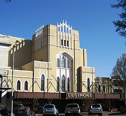 |
170 High Street, SE 44.93892°N 123.0375°W |
Salem Salem, Oregon Salem is the capital of the U.S. state of Oregon, and the county seat of Marion County. It is located in the center of the Willamette Valley alongside the Willamette River, which runs north through the city. The river forms the boundary between Marion and Polk counties, and the city neighborhood... |
||
| 37 | Farrar Building | 351–373 State Street 44.94015°N 123.0393°W |
Salem Salem, Oregon Salem is the capital of the U.S. state of Oregon, and the county seat of Marion County. It is located in the center of the Willamette Valley alongside the Willamette River, which runs north through the city. The river forms the boundary between Marion and Polk counties, and the city neighborhood... |
|||
| 38 | Henry Fawk House | 310 Lincoln Street, S 44.92527°N 123.0476°W |
Salem Salem, Oregon Salem is the capital of the U.S. state of Oregon, and the county seat of Marion County. It is located in the center of the Willamette Valley alongside the Willamette River, which runs north through the city. The river forms the boundary between Marion and Polk counties, and the city neighborhood... |
|||
| 39 | First Methodist Episcopal Church of Salem Salem First United Methodist Church Salem First United Methodist Church is a Methodist congregation and historic church in Salem, Oregon, United States. The church was listed on the National Register of Historic Places under its original name, First Methodist Episcopal Church of Salem, in 1983... |
 |
600 State Street 44.93912°N 123.0354°W |
Salem Salem, Oregon Salem is the capital of the U.S. state of Oregon, and the county seat of Marion County. It is located in the center of the Willamette Valley alongside the Willamette River, which runs north through the city. The river forms the boundary between Marion and Polk counties, and the city neighborhood... |
||
| 40 | Gaiety Hill – Bush's Pasture Park Historic District | Roughly bounded by Pringle Creek, Mission Street, Bush's Pasture Park, and Cross, High, and Liberty Streets 44.93068°N 123.0365°W (approx.) |
Salem Salem, Oregon Salem is the capital of the U.S. state of Oregon, and the county seat of Marion County. It is located in the center of the Willamette Valley alongside the Willamette River, which runs north through the city. The river forms the boundary between Marion and Polk counties, and the city neighborhood... |
|||
| 41 | Gallon House Bridge Gallon House Bridge Gallon House Bridge is a wooden covered bridge spanning Abiqua Creek in rural Marion County, Oregon, United States built in 1916. The 84 foot long bridge derived its name during prohibition when it was a meeting place for bootleggers and moonshiners. The bridge was swept off its footings in the... |
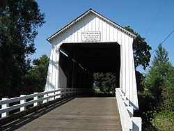 |
Abiqua Creek 45.03218°N 122.7981°W |
Silverton Silverton, Oregon Silverton is a city in Marion County, Oregon, United States, along the 45th parallel. The population was 7,414 at the 2000 census. It is part of the Salem Metropolitan Statistical Area.-Geography:... vicinity |
||
| 42 | R.C. Geer Farmhouse | image pending | 12390 Sunnyview Road 44.94106°N 122.8072°W |
Salem Salem, Oregon Salem is the capital of the U.S. state of Oregon, and the county seat of Marion County. It is located in the center of the Willamette Valley alongside the Willamette River, which runs north through the city. The river forms the boundary between Marion and Polk counties, and the city neighborhood... vicinity |
||
| 43 | Andrew T. Gilbert House A. C. Gilbert's Discovery Village The A.C. Gilbert's Discovery Village is an interactive children's museum located in Salem, Oregon, United States. This hands-on museum was named in honor of American inventor Alfred Carlton Gilbert and displays several of his inventions, most notably the Erector Set. In fact, the Village is home... |
116 Marion Street, NE 44°56′42.95"N 123°02′27.64"W |
Salem Salem, Oregon Salem is the capital of the U.S. state of Oregon, and the county seat of Marion County. It is located in the center of the Willamette Valley alongside the Willamette River, which runs north through the city. The river forms the boundary between Marion and Polk counties, and the city neighborhood... |
|||
| 44 | J.K. Gill Building | 356 State Street 44.94017°N 123.0396°W |
Salem Salem, Oregon Salem is the capital of the U.S. state of Oregon, and the county seat of Marion County. It is located in the center of the Willamette Valley alongside the Willamette River, which runs north through the city. The river forms the boundary between Marion and Polk counties, and the city neighborhood... |
|||
| 45 | Gordon House | 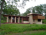 |
879 W Main Street 44.99857°N 122.7932°W |
Silverton Silverton, Oregon Silverton is a city in Marion County, Oregon, United States, along the 45th parallel. The population was 7,414 at the 2000 census. It is part of the Salem Metropolitan Statistical Area.-Geography:... |
||
| 46 | Benjamin F. Harding House | image pending | 1043 High Street, SE 44.9306°N 123.0412°W |
Salem Salem, Oregon Salem is the capital of the U.S. state of Oregon, and the county seat of Marion County. It is located in the center of the Willamette Valley alongside the Willamette River, which runs north through the city. The river forms the boundary between Marion and Polk counties, and the city neighborhood... |
||
| 47 | Hinkle–Reid House | 525 NE Alder Street 44.75493°N 122.4706°W |
Mill City Mill City, Oregon Mill City is a city in Linn and Marion counties in the U.S. state of Oregon. The population was 1,537 at the 2000 census. It is on the North Santiam River, downstream from Detroit Lake.... |
|||
| 48 | Hudson's Bay Company Granary and Clerk's House Site | image pending | 45°12′39.89"N 122°58′35.75"W | St. Paul St. Paul, Oregon St. Paul is a city in Marion County, Oregon, United States. It is named after the Saint Paul Mission founded by Archbishop François Norbert Blanchet, who arrived in the Oregon Territory in 1838 to minister to the Catholic inhabitants of French Prairie. The population was 354 at the 2000 census... |
||
| 49 | Daniel B. Jarman House and Garden | 567 High Street, SE 44.93497°N 123.0396°W |
Salem Salem, Oregon Salem is the capital of the U.S. state of Oregon, and the county seat of Marion County. It is located in the center of the Willamette Valley alongside the Willamette River, which runs north through the city. The river forms the boundary between Marion and Polk counties, and the city neighborhood... |
|||
| 50 | Jefferson Methodist Church | image pending | 310–342 N 2nd Street 44.71999°N 123.0105°W |
Jefferson Jefferson, Oregon Jefferson is a city in Marion County, Oregon, United States. It is part of the Salem Metropolitan Statistical Area. The population was 2,487 at the 2000 census... |
||
| 51 | Jones–Sherman House | 835 D Street, NE 44.94701°N 123.0273°W |
Salem Salem, Oregon Salem is the capital of the U.S. state of Oregon, and the county seat of Marion County. It is located in the center of the Willamette Valley alongside the Willamette River, which runs north through the city. The river forms the boundary between Marion and Polk counties, and the city neighborhood... |
|||
| 52 | Thomas Kay Woolen Mill Mission Mill Museum Mission Mill Museum is a historic museum located in Salem, Oregon, United States. It features working displays of a woolen mill—the Thomas Kay Woolen Mill—and several historic Salem buildings that have been relocated to the mill site.-Mill history:... |
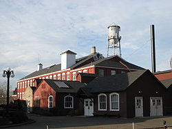 |
1313 Mill Street, SE 44.93496°N 123.0273°W |
Salem Salem, Oregon Salem is the capital of the U.S. state of Oregon, and the county seat of Marion County. It is located in the center of the Willamette Valley alongside the Willamette River, which runs north through the city. The river forms the boundary between Marion and Polk counties, and the city neighborhood... |
Included in the Mission Mill Museum Mission Mill Museum Mission Mill Museum is a historic museum located in Salem, Oregon, United States. It features working displays of a woolen mill—the Thomas Kay Woolen Mill—and several historic Salem buildings that have been relocated to the mill site.-Mill history:... . |
|
| 53 | John W. and Thomas F. Kirk House | image pending | 4686 St. Paul Highway, NE 45.20877°N 122.9635°W |
St. Paul St. Paul, Oregon St. Paul is a city in Marion County, Oregon, United States. It is named after the Saint Paul Mission founded by Archbishop François Norbert Blanchet, who arrived in the Oregon Territory in 1838 to minister to the Catholic inhabitants of French Prairie. The population was 354 at the 2000 census... |
||
| 54 | Frederick S. Lamport House | image pending | 590 Lower Ben Lomond Drive, SE 44.91698°N 123.0392°W |
Salem Salem, Oregon Salem is the capital of the U.S. state of Oregon, and the county seat of Marion County. It is located in the center of the Willamette Valley alongside the Willamette River, which runs north through the city. The river forms the boundary between Marion and Polk counties, and the city neighborhood... |
||
| 55 | Lee Mission Cemetery Lee Mission Cemetery -History:Lee Mission Cemetery was established in 1842 with the burial of Lucy Thompson Lee, the second wife of Rev. Jason Lee. The cemetery's gate has the date 1838, which is date of death for Anna Maria Pittman Lee, first wife of Jason Lee, and their infant son, who were moved to the cemetery... |
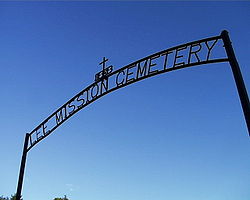 |
D Street 44.94278°N 123.0097°W |
Salem Salem, Oregon Salem is the capital of the U.S. state of Oregon, and the county seat of Marion County. It is located in the center of the Willamette Valley alongside the Willamette River, which runs north through the city. The river forms the boundary between Marion and Polk counties, and the city neighborhood... |
||
| 56 | Jason Lee House | 260 12th Street, SE 44.93382°N 123.0275°W |
Salem Salem, Oregon Salem is the capital of the U.S. state of Oregon, and the county seat of Marion County. It is located in the center of the Willamette Valley alongside the Willamette River, which runs north through the city. The river forms the boundary between Marion and Polk counties, and the city neighborhood... |
Included in the Mission Mill Museum Mission Mill Museum Mission Mill Museum is a historic museum located in Salem, Oregon, United States. It features working displays of a woolen mill—the Thomas Kay Woolen Mill—and several historic Salem buildings that have been relocated to the mill site.-Mill history:... . |
||
| 57 | T.A. Livesley House Mahonia Hall Mahonia Hall in Salem, Oregon, United States, is the official governor's mansion for Oregon. The building was acquired by the state in 1988 with private donations. It is also known as the Thomas and Edna Livesley Mansion, after its original owners. The house was renamed Mahonia Hall after the... |
image pending | 533 Lincoln Street, S 44.92537°N 123.0497°W |
Salem Salem, Oregon Salem is the capital of the U.S. state of Oregon, and the county seat of Marion County. It is located in the center of the Willamette Valley alongside the Willamette River, which runs north through the city. The river forms the boundary between Marion and Polk counties, and the city neighborhood... |
||
| 58 | S.A. Manning Building | 200–210 State Street 44.9406°N 123.0413°W |
Salem Salem, Oregon Salem is the capital of the U.S. state of Oregon, and the county seat of Marion County. It is located in the center of the Willamette Valley alongside the Willamette River, which runs north through the city. The river forms the boundary between Marion and Polk counties, and the city neighborhood... |
|||
| 59 | Marion County Housing Committee Demonstration House | image pending | 140 Wilson Street, S 44.92822°N 123.0448°W |
Salem Salem, Oregon Salem is the capital of the U.S. state of Oregon, and the county seat of Marion County. It is located in the center of the Willamette Valley alongside the Willamette River, which runs north through the city. The river forms the boundary between Marion and Polk counties, and the city neighborhood... |
||
| 60 | McCallister–Gash Farmhouse | image pending | 9626 Kaufman Road 44.96846°N 122.864°W |
Silverton Silverton, Oregon Silverton is a city in Marion County, Oregon, United States, along the 45th parallel. The population was 7,414 at the 2000 census. It is part of the Salem Metropolitan Statistical Area.-Geography:... vicinity |
||
| 61 | David McCully House | image pending | 1365 John Street, S 44.92788°N 123.0501°W |
Salem Salem, Oregon Salem is the capital of the U.S. state of Oregon, and the county seat of Marion County. It is located in the center of the Willamette Valley alongside the Willamette River, which runs north through the city. The river forms the boundary between Marion and Polk counties, and the city neighborhood... |
||
| 62 | Methodist Mission Parsonage | 1313 Mill Street, SE 44.93382°N 123.0275°W |
Salem Salem, Oregon Salem is the capital of the U.S. state of Oregon, and the county seat of Marion County. It is located in the center of the Willamette Valley alongside the Willamette River, which runs north through the city. The river forms the boundary between Marion and Polk counties, and the city neighborhood... |
Included in the Mission Mill Museum Mission Mill Museum Mission Mill Museum is a historic museum located in Salem, Oregon, United States. It features working displays of a woolen mill—the Thomas Kay Woolen Mill—and several historic Salem buildings that have been relocated to the mill site.-Mill history:... . |
||
| 63 | Miller Cemetery Church | image pending | Cascade Highway, NE 45.03915°N 122.7295°W |
Silverton Silverton, Oregon Silverton is a city in Marion County, Oregon, United States, along the 45th parallel. The population was 7,414 at the 2000 census. It is part of the Salem Metropolitan Statistical Area.-Geography:... vicinity |
||
| 64 | John and Douglas Minto Houses | image pending | 835 Saginaw Street, S 44.93315°N 123.0453°W |
Salem Salem, Oregon Salem is the capital of the U.S. state of Oregon, and the county seat of Marion County. It is located in the center of the Willamette Valley alongside the Willamette River, which runs north through the city. The river forms the boundary between Marion and Polk counties, and the city neighborhood... |
||
| 65 | Carl E. Nelson House | 960 E Street, NE 44.9474°N 123.0248°W |
Salem Salem, Oregon Salem is the capital of the U.S. state of Oregon, and the county seat of Marion County. It is located in the center of the Willamette Valley alongside the Willamette River, which runs north through the city. The river forms the boundary between Marion and Polk counties, and the city neighborhood... |
|||
| 66 | Old First National Bank Building Capitol Center (Oregon) The Capitol Center is a high-rise office building in downtown Salem, Oregon, United States. Finished in 1927, it was originally known as the First National Bank Building and owned by Salem businessman Thomas A. Livesley. The eleven story building was designed by architect Leigh L. Dougan and is the... |
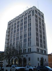 |
388 State Street 44.94006°N 123.0391°W |
Salem Salem, Oregon Salem is the capital of the U.S. state of Oregon, and the county seat of Marion County. It is located in the center of the Willamette Valley alongside the Willamette River, which runs north through the city. The river forms the boundary between Marion and Polk counties, and the city neighborhood... |
||
| 67 | Old Garfield School | 528 Cottage Street, NE 44.94357°N 123.0315°W |
Salem Salem, Oregon Salem is the capital of the U.S. state of Oregon, and the county seat of Marion County. It is located in the center of the Willamette Valley alongside the Willamette River, which runs north through the city. The river forms the boundary between Marion and Polk counties, and the city neighborhood... |
|||
| 68 | Old Woodburn City Hall | 550 N 1st Street 45.14413°N 122.8559°W |
Woodburn Woodburn, Oregon Woodburn is a city in Marion County, Oregon, United States. Incorporated in 1889, the community had been platted in 1871 after the arrival of the railroad. The city is located in the northern end of the Willamette Valley along Interstate 5 between Portland and Salem... |
|||
| 69 | Oregon Pacific Railroad Linear Historic District | image pending | Linear district in Marion, Linn National Register of Historic Places listings in Linn County, Oregon This is a list of properties and districts in Linn County, Oregon that are listed on the National Register of Historic Places.-Current listings:-Former listings:... , and Jefferson counties 44°42′15.05"N 122°05′24.02"W (approx.) |
Idanha Idanha, Oregon Idanha is a city on the Marion County/Linn County line in Oregon, United States, on Oregon Route 22 and the Santiam River. The population was 232 at the 2000 census.... to the Cascade Range Cascade Range The Cascade Range is a major mountain range of western North America, extending from southern British Columbia through Washington and Oregon to Northern California. It includes both non-volcanic mountains, such as the North Cascades, and the notable volcanoes known as the High Cascades... summit via Santiam Junction Santiam Junction, Oregon Santiam Junction is a highway junction and unincorporated locale in Linn County, Oregon, United States, at the intersection of U.S. Route 20/Oregon Route 126 and Oregon Route 22.... |
||
| 70 | Oregon State Capitol Oregon State Capitol The Oregon State Capitol is the building housing the state legislature and the offices of the governor, secretary of state, and treasurer of the U.S. state of Oregon. It is located in the state capital, Salem. The current building, constructed from 1936 to 1938, and expanded in 1977, is the third... |
Capitol Mall 44.93928°N 123.0304°W |
Salem Salem, Oregon Salem is the capital of the U.S. state of Oregon, and the county seat of Marion County. It is located in the center of the Willamette Valley alongside the Willamette River, which runs north through the city. The river forms the boundary between Marion and Polk counties, and the city neighborhood... |
|||
| 71 | Oregon State Fair Stadium and Poultry Building Ensemble Oregon State Fair -National Register of Historic Places:The state fairground is the site of two historic buildings listed on the National Register of Historic Places as the Oregon State Fair Stadium and Poultry Building Ensemble. The 1919 horse stadium and the 1921 poultry building were added to the register in 2002... |
 |
2330 17th Street, NE 44.95796°N 123.0114°W |
Salem Salem, Oregon Salem is the capital of the U.S. state of Oregon, and the county seat of Marion County. It is located in the center of the Willamette Valley alongside the Willamette River, which runs north through the city. The river forms the boundary between Marion and Polk counties, and the city neighborhood... |
||
| 72 | Oregon State Forester's Office Building Oregon State Forester's Office Building The Oregon State Forester's Office Building is a historic building in Salem, Oregon, United States that is used by the head of the Oregon Department of Forestry. The 1938 builidng was listed on the National Register of Historic Places in 1982. It was designed by Linn A. Forrest in the "National... |
2600 State Street 44.93148°N 123.0076°W |
Salem Salem, Oregon Salem is the capital of the U.S. state of Oregon, and the county seat of Marion County. It is located in the center of the Willamette Valley alongside the Willamette River, which runs north through the city. The river forms the boundary between Marion and Polk counties, and the city neighborhood... |
|||
| 73 | Oregon State Hospital Historic District Oregon State Hospital Oregon State Hospital in Salem, Oregon, United States, is the primary state-run psychiatric hospital in the state of Oregon since Dammasch State Hospital closed in 1995. The facility is best known as the filming location for the Academy Award-winning film based on Ken Kesey's novel One Flew Over... |
 |
2600 Center Street 44°56′23.72"N 123°00′12.78"W (approx.) |
Salem Salem, Oregon Salem is the capital of the U.S. state of Oregon, and the county seat of Marion County. It is located in the center of the Willamette Valley alongside the Willamette River, which runs north through the city. The river forms the boundary between Marion and Polk counties, and the city neighborhood... |
||
| 74 | Christopher Paulus Building | 355–363 Court Street, NE 44.94153°N 123.0387°W |
Salem Salem, Oregon Salem is the capital of the U.S. state of Oregon, and the county seat of Marion County. It is located in the center of the Willamette Valley alongside the Willamette River, which runs north through the city. The river forms the boundary between Marion and Polk counties, and the city neighborhood... |
|||
| 75 | Edgar T. Pierce House | image pending | 1610 Fir Street, S 44.92509°N 123.0473°W |
Salem Salem, Oregon Salem is the capital of the U.S. state of Oregon, and the county seat of Marion County. It is located in the center of the Willamette Valley alongside the Willamette River, which runs north through the city. The river forms the boundary between Marion and Polk counties, and the city neighborhood... |
||
| 76 | Pleasant Grove Presbyterian Church | 1313 Mill Street, SE 44.93382°N 123.0275°W |
Salem Salem, Oregon Salem is the capital of the U.S. state of Oregon, and the county seat of Marion County. It is located in the center of the Willamette Valley alongside the Willamette River, which runs north through the city. The river forms the boundary between Marion and Polk counties, and the city neighborhood... |
Included in the Mission Mill Museum Mission Mill Museum Mission Mill Museum is a historic museum located in Salem, Oregon, United States. It features working displays of a woolen mill—the Thomas Kay Woolen Mill—and several historic Salem buildings that have been relocated to the mill site.-Mill history:... . |
||
| 77 | Dr. Luke A. Port House Dr. Luke A. Port House The Dr. Luke A. Porthouse, also known as Historic Deepwood Estate, or simply Deepwood, is a historic house in Salem, Oregon, United States. It was designed by William C. Knighton as his first residential commission and the landscape design was done by the Salem firm of Lord & Schryver. It contains... |
1116 Mission Street, SE 44.93023°N 123.0316°W |
Salem Salem, Oregon Salem is the capital of the U.S. state of Oregon, and the county seat of Marion County. It is located in the center of the Willamette Valley alongside the Willamette River, which runs north through the city. The river forms the boundary between Marion and Polk counties, and the city neighborhood... |
|||
| 78 | Port–Manning House | 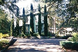 |
4922 Halls Ferry Road, S 44.88195°N 123.131°W |
Salem Salem, Oregon Salem is the capital of the U.S. state of Oregon, and the county seat of Marion County. It is located in the center of the Willamette Valley alongside the Willamette River, which runs north through the city. The river forms the boundary between Marion and Polk counties, and the city neighborhood... |
||
| 79 | Queen of Angels Priory | 840 S Main Street 45.06207°N 122.8029°W |
Mount Angel Mount Angel, Oregon Mt. Angel is a city in Marion County, Oregon, United States. It is northeast of Salem, Oregon on Oregon Route 214. The population was 3,121 at the 2000 census. Mt. Angel is part of the Salem Metropolitan Statistical Area. Portland State University Population Research Center estimate from 2008... |
|||
| 80 | Reed Opera House and McCornack Block Addition Reed Opera House and McCornack Block Addition The Reed Opera House and McCornack Block Addition, more commonly known as The Reed Opera House or The Reed, is a historic building in downtown Salem, Oregon, United States. Since its grand opening on September 27, 1870, the Reed Opera House has served as a performing arts center and shopping mall... |
 |
177–189 Liberty Street, NE 44.9411°N 123.0386°W |
Salem Salem, Oregon Salem is the capital of the U.S. state of Oregon, and the county seat of Marion County. It is located in the center of the Willamette Valley alongside the Willamette River, which runs north through the city. The river forms the boundary between Marion and Polk counties, and the city neighborhood... |
||
| 81 | Dr. and Mrs. Charles G. Robertson House and Garden | image pending | 460 Leffelle Street, S 44.92637°N 123.0493°W |
Salem Salem, Oregon Salem is the capital of the U.S. state of Oregon, and the county seat of Marion County. It is located in the center of the Willamette Valley alongside the Willamette River, which runs north through the city. The river forms the boundary between Marion and Polk counties, and the city neighborhood... |
||
| 82 | St. Mary's Roman Catholic Church St. Mary's Roman Catholic Church (Mount Angel, Oregon) St. Mary's Roman Catholic Church, located in the city of Mt. Angel, Oregon, United States in Marion County, is a historic church built in 1912. The building is listed on the U.S. National Register of Historic Places, a status it gained in 1976. The church contains 18 original stained-glass... |
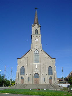 |
575 E College Street 45.06747°N 122.7939°W |
Mount Angel Mount Angel, Oregon Mt. Angel is a city in Marion County, Oregon, United States. It is northeast of Salem, Oregon on Oregon Route 214. The population was 3,121 at the 2000 census. Mt. Angel is part of the Salem Metropolitan Statistical Area. Portland State University Population Research Center estimate from 2008... |
||
| 83 | St. Paul Historic District | 45.20969°N 122.9761°W (approx.) | St. Paul St. Paul, Oregon St. Paul is a city in Marion County, Oregon, United States. It is named after the Saint Paul Mission founded by Archbishop François Norbert Blanchet, who arrived in the Oregon Territory in 1838 to minister to the Catholic inhabitants of French Prairie. The population was 354 at the 2000 census... |
|||
| 84 | St. Paul Roman Catholic Church | 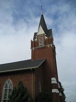 |
Junction of Christie Street and Mission Avenue, NE 45.21181°N 122.9783°W |
St. Paul St. Paul, Oregon St. Paul is a city in Marion County, Oregon, United States. It is named after the Saint Paul Mission founded by Archbishop François Norbert Blanchet, who arrived in the Oregon Territory in 1838 to minister to the Catholic inhabitants of French Prairie. The population was 354 at the 2000 census... |
||
| 85 | Salem Downtown State Street – Commercial Street Historic District | Roughly bounded by Ferry, High, Chemeketa, and Front Streets 44.94009°N 123.0394°W (approx.) |
Salem Salem, Oregon Salem is the capital of the U.S. state of Oregon, and the county seat of Marion County. It is located in the center of the Willamette Valley alongside the Willamette River, which runs north through the city. The river forms the boundary between Marion and Polk counties, and the city neighborhood... |
Located on the Willamette River Willamette River The Willamette River is a major tributary of the Columbia River, accounting for 12 to 15 percent of the Columbia's flow. The Willamette's main stem is long, lying entirely in northwestern Oregon in the United States... transportation corridor and near Jason Lee Jason Lee (missionary) Jason Lee , an American missionary and pioneer, was born on a farm near Stanstead, Quebec. He was the first of the Oregon missionaries and helped establish the early foundation of a provisional government in the Oregon Country.... 's Mission Mill Methodist Mission The Methodist Mission was founded in Oregon Country in 1834 by the Reverend Jason Lee. The mission was started to educate the Native Americans in the Willamette Valley and grew into an important center for politics and economics in the early settlement period of Oregon.-Foundation:In 1831, several... , Salem's central business district Central business district A central business district is the commercial and often geographic heart of a city. In North America this part of a city is commonly referred to as "downtown" or "city center"... was first plat Plat A plat in the U.S. is a map, drawn to scale, showing the divisions of a piece of land. Other English-speaking countries generally call such documents a cadastral map or plan.... ted in 1846. Subsequent development patterns closely reflected the drivers of Salem's growth as an important agricultural Agriculture Agriculture is the cultivation of animals, plants, fungi and other life forms for food, fiber, and other products used to sustain life. Agriculture was the key implement in the rise of sedentary human civilization, whereby farming of domesticated species created food surpluses that nurtured the... and commercial Commerce While business refers to the value-creating activities of an organization for profit, commerce means the whole system of an economy that constitutes an environment for business. The system includes legal, economic, political, social, cultural, and technological systems that are in operation in any... center. Surviving buildings represent a wide range of architectural styles from the 1860s through the 1950s. |
||
| 86 | Salem Southern Pacific Railroad Station | 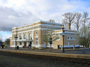 |
500 13th Avenue, SE 44°55′51.86"N 123°01′41.51"W |
Salem Salem, Oregon Salem is the capital of the U.S. state of Oregon, and the county seat of Marion County. It is located in the center of the Willamette Valley alongside the Willamette River, which runs north through the city. The river forms the boundary between Marion and Polk counties, and the city neighborhood... |
This grand Beaux-Arts style train station Train station A train station, also called a railroad station or railway station and often shortened to just station,"Station" is commonly understood to mean "train station" unless otherwise qualified. This is evident from dictionary entries e.g... , completed in 1918, is the third station to occupy the same site. The adjacent REA Railway Express Agency The Railway Express Agency was a the national monopoly set up by the Untied States federal government in 1917. Rail express services provided small package and parcel transportation using the extant railroad infrastructure much as UPS functions today using the road system... freight terminal is a remnant of the 1889 Queen Anne Queen Anne Style architecture (United States) In America, the Queen Anne style of architecture, furniture and decorative arts was popular in the United States from 1880 to 1910. In American usage "Queen Anne" is loosely used of a wide range of picturesque buildings with "free Renaissance" details rather than of a specific formulaic style in... station that burned in 1917. In 1999, the buildings were restored to their appearance during the first half of the 20th century. The site has been in continuous use for passenger Passenger A passenger is a term broadly used to describe any person who travels in a vehicle, but bears little or no responsibility for the tasks required for that vehicle to arrive at its destination.... rail service Rail transport Rail transport is a means of conveyance of passengers and goods by way of wheeled vehicles running on rail tracks. In contrast to road transport, where vehicles merely run on a prepared surface, rail vehicles are also directionally guided by the tracks they run on... from 1871 through at least 2009. |
|
| 87 | William Riley Scheurer House | 23707 1st Street, NE 45.26252°N 122.8422°W |
Aurora Aurora, Oregon Aurora is a city in Marion County, Oregon, United States. It was founded as a religious commune in 1856 by Dr. William Keil who named the settlement after his daughter. The population was 918 at the 2010 census... |
Located in Butteville Butteville, Oregon Butteville is an unincorporated community in Marion County, Oregon, United States. For statistical purposes, the United States Census Bureau has defined Butteville as a census-designated place . The census definition of the area may not precisely correspond to local understanding of the area with... along the Willamette River Willamette River The Willamette River is a major tributary of the Columbia River, accounting for 12 to 15 percent of the Columbia's flow. The Willamette's main stem is long, lying entirely in northwestern Oregon in the United States... . |
||
| 88 | Jesse H. Settlemier House Jesse H. Settlemier House Jesse H. Settlemier House is a historic house in Woodburn, Oregon, United States. It was built by Jesse H. Settlemier, founder of Woodburn, in 1892. The house is no longer inhabited but is open to the public as a museum and as a location for special events such as weddings. The house is listed on... |
 |
355 N Settlemier Avenue 45.14462°N 122.8612°W |
Woodburn Woodburn, Oregon Woodburn is a city in Marion County, Oregon, United States. Incorporated in 1889, the community had been platted in 1871 after the arrival of the railroad. The city is located in the northern end of the Willamette Valley along Interstate 5 between Portland and Salem... |
||
| 89 | U.G. Shipley House and Garden | 260 Washington Street, S 44.92426°N 123.0468°W |
Salem Salem, Oregon Salem is the capital of the U.S. state of Oregon, and the county seat of Marion County. It is located in the center of the Willamette Valley alongside the Willamette River, which runs north through the city. The river forms the boundary between Marion and Polk counties, and the city neighborhood... |
|||
| 90 | Silver Creek Youth Camp – Silver Falls State Park Silver Falls State Park Silver Falls State Park is a state park in the U.S. state of Oregon, located near Silverton, about east-southeast of Salem. It is the largest state park in Oregon with an area of more than , and it includes more than of walking trails, of horse trails, and a bike path... |
image pending | 20024 Silver Falls Highway 44.85637°N 122.6099°W (approx.) |
Sublimity Sublimity, Oregon Sublimity is a city in Marion County, Oregon, United States. As of the United States 2000 Census, the city population was 2,148. It is part of the Salem Metropolitan Statistical Area.-Geography:... vicinity |
||
| 91 | Silver Falls State Park Concession Building Area Silver Falls State Park Silver Falls State Park is a state park in the U.S. state of Oregon, located near Silverton, about east-southeast of Salem. It is the largest state park in Oregon with an area of more than , and it includes more than of walking trails, of horse trails, and a bike path... |
20024 Silver Falls Highway 44.87925°N 122.6565°W (approx.) |
Sublimity Sublimity, Oregon Sublimity is a city in Marion County, Oregon, United States. As of the United States 2000 Census, the city population was 2,148. It is part of the Salem Metropolitan Statistical Area.-Geography:... vicinity |
|||
| 92 | Silverton Commercial Historic District | Roughly bounded by High and Oak Streets, Silver Creek, and Lewis, Water, and 1st Streets 45.00488°N 122.7828°W (approx.) |
Silverton Silverton, Oregon Silverton is a city in Marion County, Oregon, United States, along the 45th parallel. The population was 7,414 at the 2000 census. It is part of the Salem Metropolitan Statistical Area.-Geography:... |
These 27 buildings in Silverton's downtown Downtown Downtown is a term primarily used in North America by English speakers to refer to a city's core or central business district .... core, dating from between 1870 and 1936, recall the twin stories of water power Hydropower Hydropower, hydraulic power, hydrokinetic power or water power is power that is derived from the force or energy of falling water, which may be harnessed for useful purposes. Since ancient times, hydropower has been used for irrigation and the operation of various mechanical devices, such as... and commercial Commerce While business refers to the value-creating activities of an organization for profit, commerce means the whole system of an economy that constitutes an environment for business. The system includes legal, economic, political, social, cultural, and technological systems that are in operation in any... development in this small Willamette Valley Willamette Valley The Willamette Valley is the most populated region in the state of Oregon of the United States. Located in the state's northwest, the region is surrounded by tall mountain ranges to the east, west and south and the valley's floor is broad, flat and fertile because of Ice Age conditions... town. |
||
| 93 | Smith–Ohmart House | image pending | 2655 East Nob Hill Street, SE 44.91527°N 123.0431°W |
Salem Salem, Oregon Salem is the capital of the U.S. state of Oregon, and the county seat of Marion County. It is located in the center of the Willamette Valley alongside the Willamette River, which runs north through the city. The river forms the boundary between Marion and Polk counties, and the city neighborhood... |
||
| 94 | South First National Bank Block | 241–247 Commercial Street, NE 44.94191°N 123.0398°W |
Salem Salem, Oregon Salem is the capital of the U.S. state of Oregon, and the county seat of Marion County. It is located in the center of the Willamette Valley alongside the Willamette River, which runs north through the city. The river forms the boundary between Marion and Polk counties, and the city neighborhood... |
|||
| 95 | Starkey–McCully Block | 223–233 Commercial Street, NE 44.94183°N 123.0398°W |
Salem Salem, Oregon Salem is the capital of the U.S. state of Oregon, and the county seat of Marion County. It is located in the center of the Willamette Valley alongside the Willamette River, which runs north through the city. The river forms the boundary between Marion and Polk counties, and the city neighborhood... |
|||
| 96 | John Stauffer House and Barn | image pending | 13551 Stauffer Road, NE 45°11′37.53"N 122°46′56.60"W |
Hubbard Hubbard, Oregon Hubbard is a city in Marion County, Oregon, United States. The population was 2,483 at the 2000 census. It is part of the Salem Metropolitan Statistical Area.-Geography:... |
||
| 97 | C.C. Stratton House | 1599 State Street 44.93561°N 123.0216°W |
Salem Salem, Oregon Salem is the capital of the U.S. state of Oregon, and the county seat of Marion County. It is located in the center of the Willamette Valley alongside the Willamette River, which runs north through the city. The river forms the boundary between Marion and Polk counties, and the city neighborhood... |
|||
| 98 | Union Street Railroad Bridge and Trestle | Junction of Union and Water Streets, NE 44.94712°N 123.042°W |
Salem Salem, Oregon Salem is the capital of the U.S. state of Oregon, and the county seat of Marion County. It is located in the center of the Willamette Valley alongside the Willamette River, which runs north through the city. The river forms the boundary between Marion and Polk counties, and the city neighborhood... |
|||
| 99 | Victor Point School | image pending | 1175 Victor Point Road, SE 44.91669°N 122.7556°W |
Silverton Silverton, Oregon Silverton is a city in Marion County, Oregon, United States, along the 45th parallel. The population was 7,414 at the 2000 census. It is part of the Salem Metropolitan Statistical Area.-Geography:... vicinity |
||
| 100 | William Lincoln Wade House | image pending | 1305 John Street, S 44.92825°N 123.0501°W |
Salem Salem, Oregon Salem is the capital of the U.S. state of Oregon, and the county seat of Marion County. It is located in the center of the Willamette Valley alongside the Willamette River, which runs north through the city. The river forms the boundary between Marion and Polk counties, and the city neighborhood... |
||
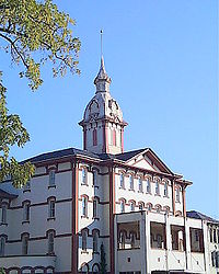
| 101 | Waller Hall, Willamette University Waller Hall Waller Hall is the oldest building on the campus of Willamette University in Salem, Oregon, United States. Built in 1867 as University Hall, the five-story, red-brick structure was added to the National Register of Historic Places in 1975... |
900 State Street 44.938°N 123.0311°W |
Salem Salem, Oregon Salem is the capital of the U.S. state of Oregon, and the county seat of Marion County. It is located in the center of the Willamette Valley alongside the Willamette River, which runs north through the city. The river forms the boundary between Marion and Polk counties, and the city neighborhood... |
|||
| 102 | Williamette Station Site, Methodist Mission in Oregon Willamette Mission State Park Willamette Mission State Park is a state park in the U.S. state of Oregon, located about four miles north of Keizer adjacent to the Wheatland Ferry and east of the Willamette River... |
image pending | 10991 Wheatland Ferry Road 45°04′50.29"N 123°01′52.81"W |
Gervais Gervais, Oregon Gervais is a city in Marion County, Oregon, United States. The population was 2,009 at the 2000 census. The 2007 estimate is 2,250 residents. It is part of the Salem Metropolitan Statistical Area.-History:... vicinity |
||
| 103 | Windischar's General Blacksmith Shop | 110 Sheridan Street 45°04′03.33"N 122°47′49.59"W |
Mount Angel Mount Angel, Oregon Mt. Angel is a city in Marion County, Oregon, United States. It is northeast of Salem, Oregon on Oregon Route 214. The population was 3,121 at the 2000 census. Mt. Angel is part of the Salem Metropolitan Statistical Area. Portland State University Population Research Center estimate from 2008... |
|||
| 104 | T.M. and Emma Witten Drug Store – House | 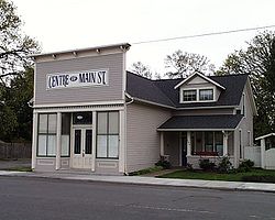 |
104 N Main Street 44.71786°N 123.0117°W |
Jefferson Jefferson, Oregon Jefferson is a city in Marion County, Oregon, United States. It is part of the Salem Metropolitan Statistical Area. The population was 2,487 at the 2000 census... |
||
| 105 | Robert Witzel House | 6576 Joseph Street, SE 44.88515°N 122.9277°W |
Salem Salem, Oregon Salem is the capital of the U.S. state of Oregon, and the county seat of Marion County. It is located in the center of the Willamette Valley alongside the Willamette River, which runs north through the city. The river forms the boundary between Marion and Polk counties, and the city neighborhood... |
|||
| 106 | Casper Zorn Farmhouse | 8448 Champoeg Road, NE 45.24538°N 122.8861°W |
St. Paul St. Paul, Oregon St. Paul is a city in Marion County, Oregon, United States. It is named after the Saint Paul Mission founded by Archbishop François Norbert Blanchet, who arrived in the Oregon Territory in 1838 to minister to the Catholic inhabitants of French Prairie. The population was 354 at the 2000 census... vicinity |
Former listings
| Site name | Image | Date listed/removed | Location | City or Town | Summary | |
|---|---|---|---|---|---|---|
| 1 | Breitenbush Guard Station Breitenbush Guard Station The Breitenbush Guard Station in Willamette National Forest, Detroit, Oregon was designed by architects of the United States Forest Service and was built by the Civilian Conservation Corps in 1935.... |
image pending | (listed) (removed) |
Willamette National Forest Willamette National Forest The Willamette National Forest is a National Forest located in the central portion of the Cascade Range of US state of Oregon.It comprises 1,675,407 acres making it one of the largest national forests. Over 380,000 acres are designated wilderness which include seven major mountain peaks... 44.78169°N 121.9676°W |
Detroit Detroit, Oregon Detroit is a city in Marion County, Oregon, United States. It was named for Detroit, Michigan in the 1890s because of the large number of people from Michigan in the community. The population was 262 at the 2000 census... vicinity |
|
| 2 | Paris Woollen Mill | image pending | (listed) (removed) |
535 E Florence Street (former) | Stayton Stayton, Oregon Stayton is a city in Marion County, Oregon, United States, located southeast of the state capital, Salem, on Oregon Route 22. It is south of Sublimity and east of Aumsville. Located on the North Santiam River, Stayton is a regional agricultural and light manufacturing center. The population was... |
|
| 3 | Wilson–Durbin House | 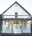 |
(listed) (removed) |
434 Water Street (former) | Salem Salem, Oregon Salem is the capital of the U.S. state of Oregon, and the county seat of Marion County. It is located in the center of the Willamette Valley alongside the Willamette River, which runs north through the city. The river forms the boundary between Marion and Polk counties, and the city neighborhood... |
This Gothic revival Gothic Revival architecture The Gothic Revival is an architectural movement that began in the 1740s in England... house was built in 1861, and was destroyed by fire in 1990. The Salem community built a replica of the house on the same site in 1999, which was incorporated into A.C. Gilbert's Discovery Village. |
See also
- National Register of Historic Places listings in Oregon
- Historic preservationHistoric preservationHistoric preservation is an endeavor that seeks to preserve, conserve and protect buildings, objects, landscapes or other artifacts of historical significance...
- History of OregonHistory of OregonThe history of Oregon, a U.S. state, may be considered in five eras: geologic history, inhabitation by native peoples, early exploration by Europeans , settlement by pioneers, and modern development....
- Lists of Oregon-related topics