
List of National Historic Landmarks in Louisiana
Encyclopedia
This is a complete list of National Historic Landmarks in Louisiana,.
The United States
National Historic Landmark
program is operated under the auspices of the National Park Service
, and recognizes structures, districts, objects, and similar resources according to a list of criteria of national significance.
The state
of Louisiana
is home to 53 of these landmarks, spanning a range of history from early to modern times. The most recently designated is the Shreveport Municipal Memorial Auditorium
, designated in October, 2008. Another NHL was once located in Louisiana, but was delisted after being destroyed. The sternwheel steamboat
Delta Queen
has been relocated to Chattanooga and is now listed as an NHL of Tennessee
.
Poverty Point National Monument is listed as a National Park Service area although title for the site has not been transferred from Louisiana to the federal government. Otherwise, excepting the El Camino Real de los Tejas trail, these are federally-owned sites and enjoy higher protection than most National Historic Landmarks.
The United States
United States
The United States of America is a federal constitutional republic comprising fifty states and a federal district...
National Historic Landmark
National Historic Landmark
A National Historic Landmark is a building, site, structure, object, or district, that is officially recognized by the United States government for its historical significance...
program is operated under the auspices of the National Park Service
National Park Service
The National Park Service is the U.S. federal agency that manages all national parks, many national monuments, and other conservation and historical properties with various title designations...
, and recognizes structures, districts, objects, and similar resources according to a list of criteria of national significance.
The state
U.S. state
A U.S. state is any one of the 50 federated states of the United States of America that share sovereignty with the federal government. Because of this shared sovereignty, an American is a citizen both of the federal entity and of his or her state of domicile. Four states use the official title of...
of Louisiana
Louisiana
Louisiana is a state located in the southern region of the United States of America. Its capital is Baton Rouge and largest city is New Orleans. Louisiana is the only state in the U.S. with political subdivisions termed parishes, which are local governments equivalent to counties...
is home to 53 of these landmarks, spanning a range of history from early to modern times. The most recently designated is the Shreveport Municipal Memorial Auditorium
Shreveport Municipal Memorial Auditorium
Shreveport Municipal Memorial Auditorium, in Shreveport, Louisiana, is an Art Deco building constructed between 1926 and 1929 during the administration of Mayor Lee Emmett Thomas as a memorial to the servicemen of World War I....
, designated in October, 2008. Another NHL was once located in Louisiana, but was delisted after being destroyed. The sternwheel steamboat
Steamboat
A steamboat or steamship, sometimes called a steamer, is a ship in which the primary method of propulsion is steam power, typically driving propellers or paddlewheels...
Delta Queen
Delta Queen
The Delta Queen is an American sternwheel steamboat that is a U.S. National Historic Landmark. Historically, she has been used for cruising the major rivers that constitute the drainage of the Mississippi River, particularly in the American South. As of June 2009, she is docked in Chattanooga,...
has been relocated to Chattanooga and is now listed as an NHL of Tennessee
Tennessee
Tennessee is a U.S. state located in the Southeastern United States. It has a population of 6,346,105, making it the nation's 17th-largest state by population, and covers , making it the 36th-largest by total land area...
.
Key
| National Historic Landmark | |
| † | National Historic Landmark District |
National Historic Landmarks
| Landmark name | Image | Date designated | Locality | Parish | Description | |
|---|---|---|---|---|---|---|
| Acadian House Acadian House (St. Martinville, Louisiana) Acadian House is a historic site in St. Martinville, Louisiana.It was declared a National Historic Landmark in 1974.It is located on Louisiana Highway 31 within Longfellow Evangeline State Park.... |
St. Martinville St. Martinville, Louisiana St. Martinville is a city in and the parish seat of St. Martin Parish, Louisiana, United States. It lies on Bayou Teche, sixteen miles south of Breaux Bridge, eighteen miles southeast of Lafayette, and nine miles north of New Iberia. The population was 6,989 at the 2000 census. It is part of the... 30.1364233174°N 91.8249965545°W |
St. Martin St. Martin Parish, Louisiana St. Martin Parish is a parish located in the U.S. state of Louisiana. The parish seat is St. Martinville. As of the 2000 census, the population was 48,583.St... |
Acadian house. | |||
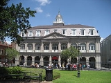
| The Cabildo The Cabildo The Cabildo was the seat of colonial government in New Orleans, Louisiana, and is now a museum. The Cabildo is located along Jackson Square, adjacent to St. Louis Cathedral.- History :The original Cabildo was destroyed in the Great New Orleans Fire... |
 |
New Orleans 29.957449°N 90.063828°W |
Orleans | Building located on Jackson Square Jackson Square, New Orleans Jackson Square, also known as Place d'Armes, is a historic park in the French Quarter of New Orleans, Louisiana. It was declared a National Historic Landmark in 1960.-Design:... . |
||
| George Washington Cable House George Washington Cable House George Washington Cable House is a cottage at 1313 8th Street in the Garden District of New Orleans, Louisiana. It was the home of George Washington Cable , an American novelist who wrote of Creole life, during the period in which he rose to national prominence.He lived in this home during... |
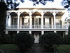 |
New Orleans 29.926405°N 90.086825°W |
Orleans | Garden District Garden District, New Orleans The Garden District is a neighborhood of the city of New Orleans. A subdistrict of the Central City/Garden District Area, its boundaries as defined by the City Planning Commission are: St. Charles Avenue to the north, 1st Street to the east, Magazine Street to the south and Toledano Street to the... cottage home of author George Washington Cable George Washington Cable George Washington Cable was an American novelist notable for the realism of his portrayals of Creole life in his native Louisiana. His fiction has been thought to anticipate that of William Faulkner.- Biography:... . |
||
| Kate Chopin House |  |
Cloutierville Cloutierville, Louisiana Cloutierville is an unincorporated community in Natchitoches Parish, Louisiana, United States. It lies about south of the city of Natchitoches on exit 119 at Interstate 49... 31.5388903442°N 92.917092447°W |
Natchitoches Natchitoches Parish, Louisiana Natchitoches Parish is a parish located in the U.S. state of Louisiana. The parish seat is Natchitoches. As of 2000, the population was 39,080. This is the heart of the Cane River Louisiana Creole community... |
Home of Kate Chopin Kate Chopin Kate Chopin, born Katherine O'Flaherty , was an American author of short stories and novels. She is now considered by some to have been a forerunner of feminist authors of the 20th century.... , author of The Awakening The Awakening (novel) The Awakening is a novel by Kate Chopin, first published in 1899 . Set in New Orleans and the Southern Louisiana coast at the end of the nineteenth century, the plot centers around Edna Pontellier and her struggle to reconcile her increasingly unorthodox views on femininity and motherhood with the... , source for her writings on bayou Bayou A bayou is an American term for a body of water typically found in flat, low-lying areas, and can refer either to an extremely slow-moving stream or river , or to a marshy lake or wetland. The name "bayou" can also refer to creeks that see level changes due to tides and hold brackish water which... life. |
||
| † | The Courthouse and Lawyers' Row Courthouse and Lawyers' Row Courthouse and Lawyers' Row is a National Historic Landmark in Clinton, Louisiana.It was declared a National Historic Landmark in 1974.-References:... |
.jpg) |
Clinton Clinton, Louisiana Clinton is a town in and the parish seat of East Feliciana Parish, Louisiana, United States. The town was named for New York Governor DeWitt Clinton. The population was 1,998 at the 2000 census. It is part of the Baton Rouge Metropolitan Statistical Area.... 30°52′0"N 91°4′7"W |
East Feliciana East Feliciana Parish, Louisiana East Feliciana Parish is a parish located in the U.S. state of Louisiana. The parish seat is Clinton. In 2000, the population was 21,360.East Feliciana Parish is part of the Baton Rouge Metropolitan Statistical Area as well as the Baton Rouge–Pierre Part Combined Statistical... |
Built in the mid-nineteenth century, this courthouse and five nearby law office buildings are examples of Greek Revival architecture Greek Revival architecture The Greek Revival was an architectural movement of the late 18th and early 19th centuries, predominantly in Northern Europe and the United States. A product of Hellenism, it may be looked upon as the last phase in the development of Neoclassical architecture... . |
|
| DELUGE (Firefighting Tug) Deluge (fireboat) Deluge , also known as Deluge , is a fireboat in New Orleans, Louisiana.It was declared a National Historic Landmark in 1989.... |
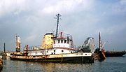 |
New Orleans 29.9541094763°N 90.0548677712°W |
Orleans | The DELUGE, a fireboat Fireboat A fireboat is a specialized watercraft and with pumps and nozzles designed for fighting shoreline and shipboard fires. The first fireboats, dating to the late 18th century, were tugboats, retrofitted with firefighting equipment.... that served the Port of New Orleans Port of New Orleans The Port of New Orleans is a port located in New Orleans, Louisiana. It is the 1st in the United States based on volume of cargo handled, second-largest in the state after the Port of South Louisiana, and 13th largest in the U.S. based on value of cargo... , is an example of large fireboats found in major ports during the 1920s. |
||
| James H. Dillard Home James H. Dillard House James H. Dillard House, also known as James H. Dillard Home, was the residence of James H. Dillard in New Orleans, Louisiana.It was declared a National Historic Landmark in 1974.... |
 |
New Orleans 29.936071°N 90.126598°W |
Orleans | This was the home of James Hardy Dillard, an educator at Tulane University Tulane University Tulane University is a private, nonsectarian research university located in New Orleans, Louisiana, United States... and director of the Slater Fund Slater Fund The John F. Slater Fund for the Education of Freedmen was created in the United States in 1882 for the encouragement of industrial education among negroes in the South.... and Jeanes Foundation Jeanes Foundation The Jeanes Foundation was founded by philanthropist Anna T. Jeanes of Philadelphia who was a Quaker. Ms. Jeanes inherited money from her father and brother's estates and was the sole owner because she was single... . Born in 1856, Dillard spent most of his life improving the education of blacks in the United States. |
||
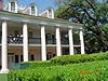
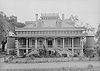
| Evergreen Plantation | 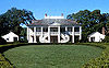 |
Wallace Wallace, Louisiana Wallace is a census-designated place in St. John the Baptist Parish, Louisiana, United States. The population was 570 at the 2000 census. It is part of the New Orleans–Metairie–Kenner Metropolitan Statistical Area... 30°01′38"N 90°38′26"W |
St. John the Baptist St. John the Baptist Parish, Louisiana St. John the Baptist Parish is a parish located in the U.S. state of Louisiana.The parish seat is Edgard, an unincorporated area and the unofficial parish captial is LaPlace, an unincorporated area. St. John the Baptist is one of the original 19 parishes in Louisiana. In 2010, its population was... |
Composed of 39 buildings, including a main house and slave quarters, Evergreen Plantation is an example of major plantation Plantation A plantation is a long artificially established forest, farm or estate, where crops are grown for sale, often in distant markets rather than for local on-site consumption... s found in the Antebellum period History of the United States (1789–1849) With the election of George Washington as the first president in 1789, the new government acted quickly to rebuild the nation's financial structure. Enacting the program of Treasury Secretary Alexander Hamilton, the government assumed the Revolutionary war debts of the state and the national... of the United States. |
||
| Fort De La Boulaye Fort De La Boulaye Site Fort De La Boulaye Site, also known as Mississippi Fort is the site of a fort built by the French in 1700, to take possession of the Mississippi. Native Americans forced the French to vacate the fort by 1707.... |
image pending | Phoenix Phoenix, Louisiana Phoenix is an unincorporated community Plaquemines Parish, Louisiana.Phoenix is located on the east bank of the Mississippi River on Louisiana Highway 39, on the opposite side of the river from Myrtle Grove.... 29°38′57"N 89°56′40"W |
Plaquemines Plaquemines Parish, Louisiana Plaquemines Parish is the parish with the most combined land and water area in the U.S. state of Louisiana. The parish seat is Pointe à la Hache... |
Fort De La Boulaye Site marks the location of a French fort built in 1700 after France took control of the mouth of the Mississippi River Mississippi River The Mississippi River is the largest river system in North America. Flowing entirely in the United States, this river rises in western Minnesota and meanders slowly southwards for to the Mississippi River Delta at the Gulf of Mexico. With its many tributaries, the Mississippi's watershed drains... . |
||
| Fort Jackson Fort Jackson, Louisiana Fort Jackson is a decommissioned masonry fort located some up river from the mouth of the Mississippi River in Plaquemines Parish, Louisiana. It was constructed as a coastal defense of New Orleans between 1822 and 1832, and was a battle site in the American Civil War. It is a National Historic... |
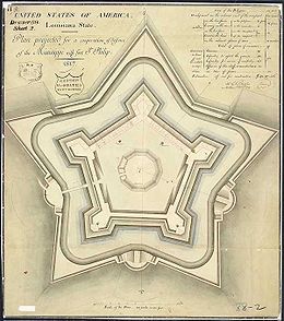 |
Triumph Triumph, Louisiana Triumph is an unincorporated community in Plaquemines Parish, Louisiana, United States. It is located on the south bank of the Mississippi River.... 29°21′28"N 89°27′18"W |
Plaquemines Plaquemines Parish, Louisiana Plaquemines Parish is the parish with the most combined land and water area in the U.S. state of Louisiana. The parish seat is Pointe à la Hache... |
Fort Jackson was constructed between 1822 and 1832. In April 1862, the fort was the site of the Battle of Forts Jackson and St. Philip Battle of Forts Jackson and St. Philip The Battle of Forts Jackson and St. Philip was the decisive battle for possession of New Orleans in the American Civil War. The two Confederate forts on the Mississippi River south of the city were attacked by a Union Navy fleet... , the decisive battle for control of New Orleans during the American Civil War American Civil War The American Civil War was a civil war fought in the United States of America. In response to the election of Abraham Lincoln as President of the United States, 11 southern slave states declared their secession from the United States and formed the Confederate States of America ; the other 25... . |
||
| Fort Jesup Fort Jesup Fort Jesup, also known as Fort Jesup State Historic Site or Fort Jessup or Fort Jesup State Monument, was built in 1822, 22 miles west of Natchitoches, Louisiana, to protect the United States border with Spain and to return order to the Neutral Strip. Originally named Cantonment Jesup, the fort... |
image pending | Many Many, Louisiana Many is a town in and the parish seat of Sabine Parish, Louisiana, United States. The population was 2,889 at the 2000 census. The town was named for John B. Many, the commander of nearby Fort Jesup.-History:... 31°36′41"N 93°24′3"W |
Sabine Sabine Parish, Louisiana Sabine Parish is a parish located in the U.S. state of Louisiana. The seat of the parish is Many. In 2010, the parish's population was 24,233.... |
Fort Jesup was built in 1822 to help protect the western border between American and Spanish territories. Under the command of future U.S. President Zachary Taylor Zachary Taylor Zachary Taylor was the 12th President of the United States and an American military leader. Initially uninterested in politics, Taylor nonetheless ran as a Whig in the 1848 presidential election, defeating Lewis Cass... , soldiers at the fort monitored Texas Texas Texas is the second largest U.S. state by both area and population, and the largest state by area in the contiguous United States.The name, based on the Caddo word "Tejas" meaning "friends" or "allies", was applied by the Spanish to the Caddo themselves and to the region of their settlement in... as it passed from Spanish and Mexican control until the Mexican–American War Mexican–American War The Mexican–American War, also known as the First American Intervention, the Mexican War, or the U.S.–Mexican War, was an armed conflict between the United States and Mexico from 1846 to 1848 in the wake of the 1845 U.S... in 1846. |
||
| Fort St. Philip Fort St. Philip Fort St. Philip is a decommissioned masonry fort located on the eastern bank of the Mississippi River, about up river from its mouth in Plaquemines Parish, Louisiana... |
 |
Triumph Triumph, Louisiana Triumph is an unincorporated community in Plaquemines Parish, Louisiana, United States. It is located on the south bank of the Mississippi River.... 29°21′50"N 89°27′46"W |
Plaquemines Plaquemines Parish, Louisiana Plaquemines Parish is the parish with the most combined land and water area in the U.S. state of Louisiana. The parish seat is Pointe à la Hache... |
|||
| Gallier Hall Gallier Hall Gallier Hall is a historic building on St. Charles Avenue in New Orleans, Louisiana. It is the former New Orleans city hall, and continues in civic use.... |
 |
New Orleans 29.948854°N 90.070820°W |
Orleans | Designed by James Gallier, Sr. James Gallier James Gallier was a prominent New Orleans architect.He was born James Gallagher in Ravensdale, County Louth, Ireland in 1798. He worked in England during his early career, designing the Godmanchester Chinese Bridge which crosses a mill stream of the River Great Ouse in 1827, and then working on the... |
||
| Gallier House Gallier House Gallier House, also known as James Gallier, Jr., House was designed by architect James Gallier, Jr. and was his home, in New Orleans, Louisiana... |
 |
New Orleans 29.961457°N 90.061583°W |
Orleans | Beautifully restored home designed by James Gallier, Jr. James Gallier, Jr. James Gallier, Jr. was a prominent architect in New Orleans, Louisiana.He was born in 1829.His father, James Gallier was also a New Orleans architect.-Significant works:... |
||
| † | Garden District Garden District, New Orleans The Garden District is a neighborhood of the city of New Orleans. A subdistrict of the Central City/Garden District Area, its boundaries as defined by the City Planning Commission are: St. Charles Avenue to the north, 1st Street to the east, Magazine Street to the south and Toledano Street to the... |
 |
New Orleans 29°55′40"N 90°05′05"W |
Orleans | ||
| Mayor Girod House Napoleon House The Napoleon House is a famous building in the French Quarter of New Orleans, Louisiana. Its name derives from the popular local story that its building was intended to be a residence for Napoleon Bonaparte after his exile; a local plot to bring Napoleon to Louisiana was halted with news of... |
 |
New Orleans 29.955886°N 90.065179°W |
Orleans | Home of Mayor Girod Nicholas Girod Nicholas Girod was the fifth mayor of New Orleans between 1812 to 1815.His private residence in the French Quarter is now known as the "Napoleon House".-References:... . |
||
| Hermann-Grima House Hermann-Grima House The Hermann-Grima House, also known as Christian Woman's Exchange is a historic home in the French Quarter of New Orleans, Louisiana.It was declared a National Historic Landmark in 1974.-External links:* * *... |
 |
New Orleans 29.957307°N 90.067484°W |
Orleans | |||
| Homeplace Plantation House Homeplace Plantation House Homeplace Plantation House, also known as Keller Homestead, is a National Historic Landmark in St. Charles Parish, Louisiana.Erected 1787-1791, this is an excellent example of a large French Colonial, two-story, raised cottage. The first-story walls are brick, while the second-story walls made of... |
.jpg) |
Hahnville Hahnville, Louisiana Hahnville is a census-designated place in and the parish seat of St. Charles Parish, Louisiana, United States. The population was 2,792 at the 2000 census... 29.9710566°N 90.4075831°W |
St. Charles St. Charles Parish, Louisiana St. Charles Parish is a parish located in the U.S. state of Louisiana. The parish seat is Hahnville. In 2010, its population was 52,780. In the eighteenth and nineteenth century, this was part of the German Coast, an area along the Mississippi River settled by numerous German pioneers in the... |
|||
| Jackson Square Jackson Square, New Orleans Jackson Square, also known as Place d'Armes, is a historic park in the French Quarter of New Orleans, Louisiana. It was declared a National Historic Landmark in 1960.-Design:... |
 |
New Orleans 29.9556451958°N 90.0630561375°W |
Orleans | |||
| USS KIDD (Destroyer) USS Kidd (DD-661) USS Kidd , a Fletcher-class destroyer, was the first ship of the United States Navy to be named for Rear Admiral Isaac C. Kidd, who died on the bridge of his flagship USS Arizona during the attack on Pearl Harbor... |
_baton_rouge.jpg) |
Baton Rouge Baton Rouge, Louisiana Baton Rouge is the capital of the U.S. state of Louisiana. It is located in East Baton Rouge Parish and is the second-largest city in the state.Baton Rouge is a major industrial, petrochemical, medical, and research center of the American South... 30.4424259628°N 91.1917173417°W |
East Baton Rouge East Baton Rouge Parish, Louisiana East Baton Rouge Parish is a parish located in the U.S. state of Louisiana. The parish seat is Baton Rouge, Louisiana's state capital. As of the 2010 census, the population was 440,171. The parish has a total area of , of which is land and is water. It is the most populous parish in the state... |
|||
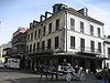
| Lafitte's Blacksmith Shop Lafitte's Blacksmith Shop Lafitte's Blacksmith Shop is a site in the French Quarter of New Orleans, Louisiana.Lafitte's Blacksmith Shop is a tavern located on the corner of Bourbon Street and St. Philip Street... |
 |
New Orleans 29.960591°N 90.063885°W |
Orleans | |||
| Longue Vue Longue Vue House and Gardens Longue Vue House and Gardens, also known as Longue Vue, is a Classical Revival mansion and garden located at 7 Bamboo Road, New Orleans, Louisiana, in the United States. It is open to the public Tuesdays to Sundays; an admission fee is charged.... |
 |
New Orleans 29°58′36.31"N 90°7′23.13"W |
Orleans | |||
| Los Adaes Los Adaes Los Adaes was the capital of Tejas on the northeastern frontier of New Spain from 1729 to 1770. It included a mission, San Miguel de Linares de los Adaes, and a presidio, Nuestra Señora del Pilar de Los Adaes . The site is located in the present-day Natchitoches Parish, Louisiana. The Los Adaes... |
image pending | Robeline Robeline, Louisiana Robeline is a village in western Natchitoches Parish, Louisiana, United States. The population was 183 at the 2000 census. It is part of the Natchitoches Micropolitan Statistical Area.... 31°42′31"N 93°17′36"W |
Natchitoches Natchitoches Parish, Louisiana Natchitoches Parish is a parish located in the U.S. state of Louisiana. The parish seat is Natchitoches. As of 2000, the population was 39,080. This is the heart of the Cane River Louisiana Creole community... |
Los Adaes was the capitol of Tejas Coahuila y Tejas Coahuila y Tejas was one of the constituent states of the newly established United Mexican States under its 1824 Constitution.It had two capitals: first Saltillo, and then Monclova... on the northeastern frontier of New Spain from 1729 to 1770. It included a mission, San Miguel de los Adaes and a presidio, Nuestra Senora del Pilar de Los Adaes (Our Lady of Pilar of the Adaes). |
||
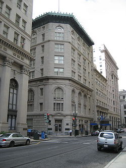
| Louisiana State Bank Building Louisiana State Bank Building Louisiana State Bank Building is a building in New Orleans, Louisiana. It has also been known as the Manheim Galleries building, from a long time tenant. It is located in the French Quarter at the downtown lake corner of Royal Street and Conti.... |
.jpg) |
New Orleans 29.956014°N 90.066466°W |
Orleans | |||
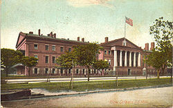
| Louisiana State Capitol Louisiana State Capitol The Louisiana State Capitol building is the capitol building of the state of Louisiana, located in Baton Rouge. The capitol houses the Louisiana State Legislature, the governor's office, and parts of the executive branch... |
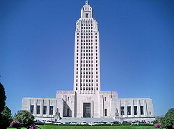 |
Baton Rouge Baton Rouge, Louisiana Baton Rouge is the capital of the U.S. state of Louisiana. It is located in East Baton Rouge Parish and is the second-largest city in the state.Baton Rouge is a major industrial, petrochemical, medical, and research center of the American South... 30°27′25"N 91°11′15"W |
East Baton Rouge East Baton Rouge Parish, Louisiana East Baton Rouge Parish is a parish located in the U.S. state of Louisiana. The parish seat is Baton Rouge, Louisiana's state capital. As of the 2010 census, the population was 440,171. The parish has a total area of , of which is land and is water. It is the most populous parish in the state... |
|||
| Madame John's Legacy Madame John's Legacy Madame John's Legacy is a house in the French Quarter of New Orleans, Louisiana. The name is taken from a story by George Washington Cable. The house was built in 1788, after a fire destroyed much of the neighborhood... |
 |
New Orleans 29.959332°N 90.062902°W |
Orleans | Building which got its name from a story by George Washington Cable George Washington Cable George Washington Cable was an American novelist notable for the realism of his portrayals of Creole life in his native Louisiana. His fiction has been thought to anticipate that of William Faulkner.- Biography:... . |
||
| Madewood Plantation House Madewood Plantation House Madewood Plantation House, also known as Madewood, is a National Historic Landmark in Napoleonville, Louisiana, USA. Built for the Pugh family in 1845 and designed by architect Henry Howard, the house was originally part of a sugar plantation.... |
Napoleonville Napoleonville, Louisiana Napoleonville is a village in and the parish seat of Assumption Parish, in the U.S. state of Louisiana. The population was 686 at the 2000 census. It is part of the Pierre Part Micropolitan Statistical Area.-History:... 29°55′33"N 90°59′39"W |
Assumption Assumption Parish, Louisiana Assumption Parish is a parish located in the U.S. state of Louisiana, and was formed in 1807 as an original parish of the Louisiana Territory. Its parish seat is Napoleonville. In 2000, its population was 23,388. Assumption is one of the 22 Acadiana parishes. Its major product is sugarcane... |
||||
| Magnolia Plantation Magnolia Plantation (Derry, Louisiana) Magnolia Plantation is a former plantation in Natchitoches Parish, Louisiana. The site was declared a National Historic Landmark in 2001. Included in the Cane River Creole National Historical Park, Magnolia Plantation is also a destination on the Louisiana African American Heritage... |
.jpg) |
Derry Derry, Louisiana Derry is a town in unincorporated Natchitoches Parish, Louisiana, United States, located on Louisiana Highway 1.It is the closest town to Magnolia Plantation, a National Historic Landmark.... 31°32′59"N 92°56′26"W |
Natchitoches Natchitoches Parish, Louisiana Natchitoches Parish is a parish located in the U.S. state of Louisiana. The parish seat is Natchitoches. As of 2000, the population was 39,080. This is the heart of the Cane River Louisiana Creole community... |
|||
| Marksville Prehistoric Indian Site Marksville Prehistoric Indian Site Marksville Prehistoric Indian Site, , also known as Marksville State Historic Site, is a Hopewell tradition earthworks archaeological site in Louisiana, one mile southeast of Marksville in Avoyelles Parish.-Description:... |
Marksville Marksville, Louisiana Marksville is a city in and the parish seat of Avoyelles Parish, Louisiana, United States. The population was 5,537 at the 2000 census. Louisiana's first land-based casino, Paragon Casino Resort, opened in Marksville in June 1994... 31°07′29"N 92°02′52"W |
Avoyelles Avoyelles Parish, Louisiana Avoyelles is a parish located in the U.S. state of Louisiana. The parish seat is Marksville. In 2000, its population was 41,481. The parish is named for the Avoyel Indian tribe.-History:... |
Archeological type site Type site In archaeology a type site is a site that is considered the model of a particular archaeological culture... for Marksville culture Marksville culture The Marksville culture was an archaeological culture in the lower Lower Mississippi valley, Yazoo valley, and Tensas valley areas of Louisiana, Mississippi, Missouri, Arkansas and extended eastward along the Gulf Coast to the Mobile Bay area, from 100 BCE to 400 CE. This culture takes its name... . |
|||
| † | Natchitoches Historic District Natchitoches Historic District Natchitoches Historic District, also known as Natchitoches National Historic Landmark District is a historic district in Natchitoches, Louisiana, the oldest permanent settlement in Louisiana. Natchitoches was founded by the French in 1714... |
.jpg) |
Natchitoches Natchitoches, Louisiana Natchitoches is a city in and the parish seat of Natchitoches Parish, Louisiana, United States. Established in 1714 by Louis Juchereau de St. Denis as part of French Louisiana, the community was named after the Natchitoches Indian tribe. The City of Natchitoches was first incorporated on February... 31.754330°N 93.092108°W |
Natchitoches Natchitoches Parish, Louisiana Natchitoches Parish is a parish located in the U.S. state of Louisiana. The parish seat is Natchitoches. As of 2000, the population was 39,080. This is the heart of the Cane River Louisiana Creole community... |
Nachtitoches was the first permanent settlement founded by the French in Louisiana. | |
| New Orleans Cotton Exchange Building New Orleans Cotton Exchange The New Orleans Cotton Exchange was established in New Orleans, Louisiana, in 1871 as a centralized forum for the trade of cotton. It operated in New Orleans until closing in 1964... |
 |
New Orleans 29.952394°N 90.071001°W |
Orleans | |||
| Oak Alley Plantation Oak Alley Plantation Oak Alley Plantation is a historic plantation located on the Mississippi River in the community of Vacherie, Louisiana. It is protected as a National Historic Landmark... |
 |
Vacherie Vacherie, Louisiana Vacherie is a small unincorporated community in St. James Parish, Louisiana, United States. Near the community is the WCKW/KSTE-Tower, a guyed mast noted as one of the tallest constructions on Earth.-Census-designated places:... 30.0042799°N 90.7759333°W |
St. James | |||
| Oakland Plantation | Natchez Natchez, Louisiana Natchez is a village in Natchitoches Parish, Louisiana, United States. The population was 583 at the 2000 census. It is part of the Natchitoches Micropolitan Statistical Area.... 31°39′54"N 93°0′12"W |
Natchitoches Natchitoches Parish, Louisiana Natchitoches Parish is a parish located in the U.S. state of Louisiana. The parish seat is Natchitoches. As of 2000, the population was 39,080. This is the heart of the Cane River Louisiana Creole community... |
||||
| Old Louisiana State Capitol Old Louisiana State Capitol The Louisiana's Old State Capitol is a building in Baton Rouge, Louisiana, United States that housed the Louisiana State Legislature from the mid-19th century until the current capitol tower building was constructed in 1929.... |
 |
Baton Rouge Baton Rouge, Louisiana Baton Rouge is the capital of the U.S. state of Louisiana. It is located in East Baton Rouge Parish and is the second-largest city in the state.Baton Rouge is a major industrial, petrochemical, medical, and research center of the American South... 30.4450262151°N 91.1886080432°W |
East Baton Rouge East Baton Rouge Parish, Louisiana East Baton Rouge Parish is a parish located in the U.S. state of Louisiana. The parish seat is Baton Rouge, Louisiana's state capital. As of the 2010 census, the population was 440,171. The parish has a total area of , of which is land and is water. It is the most populous parish in the state... |
Innovatively designed by architect James H. Dakin James H. Dakin James Harrison Dakin , American architect, was the son of James and Lucy Harrison Dakin of Hudson, New York, and born in Northeast Township. He was seventh in line from the immigrant ancestor, Thomas Dakin, of Concord, Massachusetts, through Simon, of the third generation, who went to Putnam... , it is "Castellated Gothic". |
||
| Parlange Plantation House Parlange plantation house The Parlange Plantation, built about 1750 in southeastern Louisiana, is a classic example of a large French Colonial plantation house in the United States. Exemplifying the style of the semitropical Louisiana country house, the Parlange Plantation House is a two-story raised cottage. The main... |
.jpg) |
Mix Mix, Louisiana Mix is an unincorporated community in Pointe Coupee Parish, Louisiana, United States. It is the home of the Parlange Plantation House, a National Historic Landmark. It is located along Louisiana Highway 1, south of New Roads, Louisiana. Mix is home to the Parlange Plantation House.-History:The... 30°37′49"N 91°29′10"W |
Pointe Coupee Pointe Coupee Parish, Louisiana Pointe Coupee Parish, pronounced "Pwent Koo-Pay" and , is a parish located in the U.S. state of Louisiana. The parish seat is New Roads. As of 2000, the population was 22,763.... |
|||
| Pontalba Buildings Pontalba Buildings The Pontalba Buildings form two sides of Jackson Square in the French Quarter of New Orleans, Louisiana.These are matching red-brick block long 4‑story buildings built in the 1840s by the Baroness Micaela Almonester Pontalba... |
 |
New Orleans 29.957580°N 90.062145°W |
Orleans | |||
| Port Hudson Port Hudson National Cemetery Port Hudson National Cemetery is a United States National Cemetery located in Port Hudson, north of the city of Baton Rouge in East Baton Rouge Parish, Louisiana. It encompasses , and as of the end of 2007, had 12,718 interments.... |
 |
Port Hudson Port Hudson, Louisiana Port Hudson is a small unincorporated community in East Baton Rouge Parish, Louisiana, United States. Located about northwest of Baton Rouge, it is most famous for an American Civil War battle known as the Siege of Port Hudson.-Geography:... 30°39′38.059"N 91°16′26.926"W |
East Feliciana East Feliciana Parish, Louisiana East Feliciana Parish is a parish located in the U.S. state of Louisiana. The parish seat is Clinton. In 2000, the population was 21,360.East Feliciana Parish is part of the Baton Rouge Metropolitan Statistical Area as well as the Baton Rouge–Pierre Part Combined Statistical... |
American Civil War American Civil War The American Civil War was a civil war fought in the United States of America. In response to the election of Abraham Lincoln as President of the United States, 11 southern slave states declared their secession from the United States and formed the Confederate States of America ; the other 25... battleground, the last Confederate stronghold on the Mississippi River Mississippi River The Mississippi River is the largest river system in North America. Flowing entirely in the United States, this river rises in western Minnesota and meanders slowly southwards for to the Mississippi River Delta at the Gulf of Mexico. With its many tributaries, the Mississippi's watershed drains... . |
||
| Poverty Point Poverty Point Poverty Point is a prehistoric earthworks of the Poverty Point culture, now a historic monument located in the Southern United States. It is from the current Mississippi River, and situated on the edge of Maçon Ridge, near the village of Epps in West Carroll Parish, Louisiana.Poverty Point... |
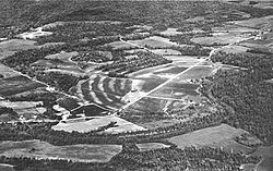 |
Delhi Delhi, Louisiana Delhi, originally called Deerfield, is a town in Richland Parish, Louisiana, in the United States. As of the 2000 census, the town population was 3,066.-History:... 32°38′12"N 91°24′41"W |
West Carroll West Carroll Parish, Louisiana West Carroll Parish is a parish located in the U.S. state of Louisiana. The parish seat is Oak Grove and as of 2000, the population was 12,314.-History:... |
|||
| The Presbytere The Presbytere The Presbytère, also known as The Presbytere, is an important historical building in New Orleans, Louisiana and is located in the French Quarter along Jackson Square, adjacent to the St... |
 |
New Orleans 29.957830°N 90.063450°W |
Orleans | Building located on Jackson Square Jackson Square, New Orleans Jackson Square, also known as Place d'Armes, is a historic park in the French Quarter of New Orleans, Louisiana. It was declared a National Historic Landmark in 1960.-Design:... . |
||
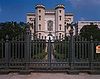
| † | Rosedown Rosedown Plantation Rosedown Plantation is located in the West Feliciana community of St. Francisville along one of the most historic corridors in South Louisiana.Society in and around St. Francisville, at the time that Rosedown was constructed, was dominated by European, primarily British, settlers who became cotton... |
.jpg) |
St. Francisville St. Francisville, Louisiana St. Francisville is a town in and the parish seat of West Feliciana Parish, Louisiana, United States. The population was 1,712 at the 2000 census. It is part of the Baton Rouge Metropolitan Statistical Area.-Geography:St... 30.796015°N 91.370945°W |
West Feliciana West Feliciana Parish, Louisiana -Demographics:As of the census of 2000, there were 15,111 people, 3,645 households, and 2,704 families residing in the parish. The population density was 37 people per square mile . There were 4,485 housing units at an average density of 11 per square mile... |
||
| Saint Alphonsus Church | 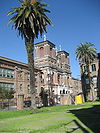 |
New Orleans 29°55′50"N 90°4′25"W |
Orleans | |||
| St. Mary's Assumption Church |  |
New Orleans 29.929888°N 90.074293°W |
Orleans | |||
| St. Patrick's Church (New Orleans) |  |
New Orleans 29.946631°N 90.070137°W |
Orleans | |||
| San Francisco Plantation House San Francisco Plantation House San Francisco Plantation House is a National Historic Landmark in St. John the Baptist Parish, Louisiana.It was declared a National Historic Landmark in 1974.It is located about upriver of Reserve, Louisiana, on Louisiana Highway 144.... |
 |
Reserve Reserve, Louisiana Reserve is a census-designated place in St. John the Baptist Parish, Louisiana, United States, on the east bank of the Mississippi River. The population was 9,111 at the 2000 census... 30.0475350796°N 90.605547603°W |
St. John the Baptist St. John the Baptist Parish, Louisiana St. John the Baptist Parish is a parish located in the U.S. state of Louisiana.The parish seat is Edgard, an unincorporated area and the unofficial parish captial is LaPlace, an unincorporated area. St. John the Baptist is one of the original 19 parishes in Louisiana. In 2010, its population was... |
|||
| Shadows-on-the-Teche Shadows-on-the-Teche Shadows-on-the-Teche is an historic house and garden owned and operated by the National Trust for Historic Preservation. It was built in 1831-1834 for sugarcane planter David Weeks and his wife Mary C. Weeks... |
.jpg) |
New Iberia New Iberia, Louisiana New Iberia is a city in and the parish seat of Iberia Parish, Louisiana, United States, 30 miles southeast of Lafayette. In 1900, 6,815 people lived in New Iberia; in 1910, 7,499; and in 1940, 13,747... 30.0025412971°N 91.814996885°W |
Iberia Iberia Parish, Louisiana Iberia Parish is a parish located in the U.S. state of Louisiana. The parish seat is New Iberia. As of 2000, the population was 73,266.Iberia Parish is part of the New Iberia Micropolitan Statistical Area as well as the Lafayette–Acadiana Combined Statistical Area.Iberia, along with... |
|||
| Shreveport Municipal Memorial Auditorium Shreveport Municipal Memorial Auditorium Shreveport Municipal Memorial Auditorium, in Shreveport, Louisiana, is an Art Deco building constructed between 1926 and 1929 during the administration of Mayor Lee Emmett Thomas as a memorial to the servicemen of World War I.... |
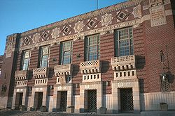 |
Shreveport Shreveport, Louisiana Shreveport is the third largest city in Louisiana. It is the principal city of the fourth largest metropolitan area in the state of Louisiana and is the 109th-largest city in the United States.... 32°30′28"N 93°45′10"W |
Caddo Caddo Parish, Louisiana Caddo Parish is a parish located in the U.S. state of Louisiana. The parish seat is Shreveport; as of 2000, the population was 252,161... |
|||
| Shreveport Waterworks Pumping Station Shreveport Waterworks Pumping Station Shreveport Waterworks Pumping Station, also known as Shreveport Water Works Company, Pump Station or McNeil Street Pump Station, is a National Historic Landmark in Shreveport, Louisiana.It was declared a National Historic Landmark in 1982.... |
.jpg) |
Shreveport Shreveport, Louisiana Shreveport is the third largest city in Louisiana. It is the principal city of the fourth largest metropolitan area in the state of Louisiana and is the 109th-largest city in the United States.... 32.5156823128°N 93.7569948027°W |
Caddo Caddo Parish, Louisiana Caddo Parish is a parish located in the U.S. state of Louisiana. The parish seat is Shreveport; as of 2000, the population was 252,161... |
An engineering landmark. | ||
| United States Customhouse (New Orleans) | 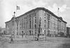 |
New Orleans 29.951414°N 90.066254°W |
Orleans | |||
| United States Mint, New Orleans Branch New Orleans Mint The New Orleans Mint operated in New Orleans, Louisiana, as a branch mint of the United States Mint from 1838 to 1861 and from 1879 to 1909. During its years of operation, it produced over 427 million gold and silver coins of nearly every American denomination, with a total face value of over... |
 |
New Orleans 29.961436°N 90.057266°W |
Orleans | |||
| Ursuline Convent |  |
New Orleans 29.960753°N 90.060813°W |
Orleans | An Ursuline Ursulines The Ursulines are a Roman Catholic religious order for women founded at Brescia, Italy, by Saint Angela de Merici in November 1535, primarily for the education of girls and the care of the sick and needy. Their patron saint is Saint Ursula.-History:St Angela de Merici spent 17 years leading a... convent Convent A convent is either a community of priests, religious brothers, religious sisters, or nuns, or the building used by the community, particularly in the Roman Catholic Church and in the Anglican Communion... |
||
| † | Vieux Carre Historic District French Quarter The French Quarter, also known as Vieux Carré, is the oldest neighborhood in the city of New Orleans. When New Orleans was founded in 1718 by Jean-Baptiste Le Moyne de Bienville, the city was originally centered on the French Quarter, or the Vieux Carré as it was known then... |
 |
New Orleans 29°57′31"N 90°03′54"W |
Orleans | The French Quarter French Quarter The French Quarter, also known as Vieux Carré, is the oldest neighborhood in the city of New Orleans. When New Orleans was founded in 1718 by Jean-Baptiste Le Moyne de Bienville, the city was originally centered on the French Quarter, or the Vieux Carré as it was known then... . |
|
| Edward Douglass White House Edward Douglass White House The Edward Douglass White House, also known as Edward Douglass White Louisiana State Commemorative Area, is a National Historic Landmark near Thibodaux, Louisiana.It was declared a National Historic Landmark in 1976.... |
image pending | Thibodaux Thibodaux, Louisiana Thibodaux is a small city in and the parish seat of Lafourche Parish, Louisiana, United States, along the banks of Bayou Lafourche in the northwestern part of the parish. The population was 14,431 at the 2000 census. Thibodaux is a principal city of the Houma–Bayou Cane–Thibodaux... 29°45′14.5"N 90°43′45.5"W |
Lafourche Lafourche Parish, Louisiana Lafourche Parish is a parish located in the south of the U.S. state of Louisiana. It was originally the northern part of Lafourche Interior Parish, which consisted of the present parishes of Lafourche and Terrebonne. The parish seat is Thibodaux... |
Home of Edward Douglass White Edward Douglass White Edward Douglass White, Jr. , American politician and jurist, was a United States senator, Associate Justice of the United States Supreme Court and the ninth Chief Justice of the United States. He was best known for formulating the Rule of Reason standard of antitrust law. He also sided with the... . |
||
| † | Yucca Plantation Melrose Plantation Melrose Plantation, also known as Yucca Plantation, is a National Historic Landmark in Natchitoches Parish in north central Louisiana. This is one of the largest plantations in the United States built by and for free blacks... |
.jpg) |
Melrose Melrose, Louisiana Melrose is an unincorporated community in Natchitoches Parish, Louisiana, including the Melrose Plantation and surrounding area, on Louisiana Highway 119. In addition to the historic plantation, the Cane River Creole National Historical Park and Heritage Area encompass the Melrose area.Melrose is... 31.087710696°N 92.967560848°W |
Natchitoches Natchitoches Parish, Louisiana Natchitoches Parish is a parish located in the U.S. state of Louisiana. The parish seat is Natchitoches. As of 2000, the population was 39,080. This is the heart of the Cane River Louisiana Creole community... |
Black businesswoman Marie Thérèse Coincoin Marie Thérèse Metoyer Marie Thérèse ditte Coincoin was notable as a free médecine, planter, and businesswoman in Natchitoches Parish. She was freed from slavery after a long liaison and ten children with Claude Thomas Pierre Métoyer... created this plantation, includes perhaps the first black for black designed buildings in the United States. |
Former National Historic Landmark
| Landmark name | Image | Date designated | Locality | Parish | Description | |
|---|---|---|---|---|---|---|
| 1 | DELTA QUEEN (River Steamboat) Delta Queen The Delta Queen is an American sternwheel steamboat that is a U.S. National Historic Landmark. Historically, she has been used for cruising the major rivers that constitute the drainage of the Mississippi River, particularly in the American South. As of June 2009, she is docked in Chattanooga,... |
 |
New Orleans 29.9325528924°N 90.0608358546°W |
Orleans | River steamboat Steamboat A steamboat or steamship, sometimes called a steamer, is a ship in which the primary method of propulsion is steam power, typically driving propellers or paddlewheels... . Has been relocated to Chattanooga Chattanooga, Tennessee Chattanooga is the fourth-largest city in the US state of Tennessee , with a population of 169,887. It is the seat of Hamilton County... , Tennessee Tennessee Tennessee is a U.S. state located in the Southeastern United States. It has a population of 6,346,105, making it the nation's 17th-largest state by population, and covers , making it the 36th-largest by total land area... . |
|
| 2 | U.S.S. Cabot (CVL-28) USS Cabot (CVL-28) USS Cabot was an in the United States Navy, the second ship to carry the name. Cabot was commissioned in 1943 and served until 1947. She was recommissioned as a training carrier from 1948 to 1955. From 1967 to 1989, she served in Spain as '... |
.jpg) |
June 29, 1990 | New Orleans 29.920988226°N 90.0700279425°W |
Orleans | Commissioned in 1943, The USS Cabot (CVL-28/AVT-3) was an in the United States Navy United States Navy The United States Navy is the naval warfare service branch of the United States Armed Forces and one of the seven uniformed services of the United States. The U.S. Navy is the largest in the world; its battle fleet tonnage is greater than that of the next 13 largest navies combined. The U.S... . From 1967-1989, she served in Spain as the . A New Orleans-based museum foundation purchased the ship for restoration in 1990, but was unable to obtain sufficient funding. The Cabot was eventually scrapped and withdrawn as a Landmark on August 7, 2001. |
National Park Service Areas in Louisiana
National Historic Sites and other National Park Service areas in Louisiana are:- Cane River Creole National Historical ParkCane River Creole National Historical ParkCane River Creole National Historical Park is located within the Cane River National Heritage Area in Natchitoches Parish, Louisiana. The United States National Historical Park protects a total of 67 historic structures at two locations, Magnolia Plantation and Oakland Plantation. Both plantation...
- Chalmette National CemeteryChalmette National CemeteryChalmette National Cemetery is a United States National Cemetery located within Jean Lafitte National Historical Park and Preserve in Chalmette, Louisiana. The cemetery is a plot adjacent to the site that once was the battleground of the Battle of New Orleans...
- El Camino Real de los Tejas National Historic TrailEl Camino Real de los Tejas National Historic TrailThe El Camino Real de los Tejas National Historic Trail is a National Historic Trail covering the U.S. section of the El Camino Real de Los Tejas from 17th century Spanish colonial era in Spanish Texas...
- Jean Lafitte National Historical Park and PreserveJean Lafitte National Historical Park and PreserveJean Lafitte National Historical Park and Preserve protects significant examples of the rich natural and cultural resources of Louisiana's Mississippi River Delta region. The park, named after Jean Lafitte, seeks to illustrate the influence of environment and history on the development of a unique...
- New Orleans Jazz National Historical ParkNew Orleans Jazz National Historical ParkNew Orleans Jazz National Historical Park is a U.S. National Historical Parkin the Treme neighborhood of New Orleans, Louisiana, near the French Quarter. It was created in 1994 to celebrate the origins and evolution of jazz, America’s most widely-recognized genre of music.The park consists of ...
- Poverty Point National Monument
- Vicksburg National Military ParkVicksburg National Military ParkVicksburg National Military Park preserves the site of the American Civil War Battle of Vicksburg, waged from May 18 to July 4, 1863. The park, in Vicksburg, Mississippi, and Delta, Louisiana, also commemorates the greater Vicksburg Campaign, which preceded the battle. Reconstructed forts and...
(also in Mississippi)
Poverty Point National Monument is listed as a National Park Service area although title for the site has not been transferred from Louisiana to the federal government. Otherwise, excepting the El Camino Real de los Tejas trail, these are federally-owned sites and enjoy higher protection than most National Historic Landmarks.
See also
- List of National Historic Landmarks by state
- National Register of Historic Places listings in Louisiana
- Historic preservationHistoric preservationHistoric preservation is an endeavor that seeks to preserve, conserve and protect buildings, objects, landscapes or other artifacts of historical significance...
- National Register of Historic PlacesNational Register of Historic PlacesThe National Register of Historic Places is the United States government's official list of districts, sites, buildings, structures, and objects deemed worthy of preservation...
- History of LouisianaHistory of LouisianaThe history of Louisiana is long and rich. From its earliest settlement by Native Americans to its status as linchpin of an empire to its incorporation as a U.S...