

Natchitoches Parish, Louisiana
Encyclopedia
Natchitoches Parish is a parish located in the U.S. state
of Louisiana
. The parish seat is Natchitoches
. As of 2000, the population was 39,080. This is the heart of the Cane River
Louisiana Creole
community. The Natchitoches Micropolitan Statistical Area includes all of Natchitoches Parish.
Including extensive outbuildings at Magnolia
and Oakland
plantations, the Cane River Creole National Historical Park
interprets the history and culture of the Louisiana Creoles. It was designated one of the original sites on the Louisiana African American Heritage Trail
.
es, including Orleans, Iberville
, Rapides
and Natchitoches.
of 2000, there were 39,080 people, 14,263 households, and 9,499 families residing in the parish. The population density
was 31 people per square mile (12/km²). There were 16,890 housing units at an average density of 14 per square mile (5/km²). The racial makeup of the parish was 57.85% White
, 38.43% Black
or African American
, 1.08% Native American
, 0.44% Asian
, 0.02% Pacific Islander
, 0.92% from other races
, and 1.27% from two or more races. 1.45% of the population were Hispanic
or Latino
of any race.
There were 14,263 households out of which 33.00% had children under the age of 18 living with them, 45.30% were married couples
living together, 17.70% had a female householder with no husband present, and 33.40% were non-families. 27.10% of all households were made up of individuals and 10.90% had someone living alone who was 65 years of age or older. The average household size was 2.56 and the average family size was 3.14.
In the parish the population was spread out with 26.00% under the age of 18, 17.90% from 18 to 24, 24.30% from 25 to 44, 19.70% from 45 to 64, and 12.10% who were 65 years of age or older. The median age was 30 years. For every 100 females there were 90.60 males. For every 100 females age 18 and over, there were 85.80 males.
The median income for a household in the parish was $25,722, and the median income for a family was $32,816. Males had a median income of $29,388 versus $19,234 for females. The per capita income
for the parish was $13,743. About 20.90% of families and 26.50% of the population were below the poverty line, including 32.70% of those under age 18 and 19.00% of those age 65 or over.
operates local public schools.
Several former rural schools, such as Ashland High School
and Goldonna High School in the villages of Ashland and Goldonna, have closed over the years under school consolidation.
See also: List of counties bordering eight counties
U.S. state
A U.S. state is any one of the 50 federated states of the United States of America that share sovereignty with the federal government. Because of this shared sovereignty, an American is a citizen both of the federal entity and of his or her state of domicile. Four states use the official title of...
of Louisiana
Louisiana
Louisiana is a state located in the southern region of the United States of America. Its capital is Baton Rouge and largest city is New Orleans. Louisiana is the only state in the U.S. with political subdivisions termed parishes, which are local governments equivalent to counties...
. The parish seat is Natchitoches
Natchitoches, Louisiana
Natchitoches is a city in and the parish seat of Natchitoches Parish, Louisiana, United States. Established in 1714 by Louis Juchereau de St. Denis as part of French Louisiana, the community was named after the Natchitoches Indian tribe. The City of Natchitoches was first incorporated on February...
. As of 2000, the population was 39,080. This is the heart of the Cane River
Cane River
Cane River is a lake and river formed from a portion of the Red River that is located in Natchitoches Parish, Louisiana. In the 19th and 20th centuries, it has been best known as the site of a historic Creole de couleur culture that has centers upon the National Historic Landmark Melrose...
Louisiana Creole
Louisiana Creole
Louisiana Creole can refer to:* Louisiana Creole people* Louisiana Creole French language* Louisiana Creole cuisine...
community. The Natchitoches Micropolitan Statistical Area includes all of Natchitoches Parish.
Including extensive outbuildings at Magnolia
Magnolia Plantation (Derry, Louisiana)
Magnolia Plantation is a former plantation in Natchitoches Parish, Louisiana. The site was declared a National Historic Landmark in 2001. Included in the Cane River Creole National Historical Park, Magnolia Plantation is also a destination on the Louisiana African American Heritage...
and Oakland
Oakland Plantation (Natchez, Louisiana)
Oakland Plantation was originally known as the Jean Pierre Emmanuel Prud'homme Plantation. It is also known as Bermuda. Declared a National Historic Landmark in 2001, it is part of Cane River Creole National Historical Park near Natchitoches, Louisiana.The plantation is associated with Atahoe...
plantations, the Cane River Creole National Historical Park
Cane River Creole National Historical Park
Cane River Creole National Historical Park is located within the Cane River National Heritage Area in Natchitoches Parish, Louisiana. The United States National Historical Park protects a total of 67 historic structures at two locations, Magnolia Plantation and Oakland Plantation. Both plantation...
interprets the history and culture of the Louisiana Creoles. It was designated one of the original sites on the Louisiana African American Heritage Trail
Louisiana African American Heritage Trail
Louisiana African American Heritage Trail is a cultural heritage trail with 26 sites designated in 2008 by the state of Louisiana, from New Orleans along the Mississippi River to Baton Rouge and Shreveport, with sites in small towns and plantations also included. In New Orleans several sites are...
.
History
Natchitoches Parish was created by the act of April 10, 1805 that divided the Territory of Orleans into 12 parishParish
A parish is a territorial unit historically under the pastoral care and clerical jurisdiction of one parish priest, who might be assisted in his pastoral duties by a curate or curates - also priests but not the parish priest - from a more or less central parish church with its associated organization...
es, including Orleans, Iberville
Iberville Parish, Louisiana
Iberville Parish is a parish located south of Baton Rouge in the U.S. state of Louisiana. Its seat is Plaquemine. The 2010 population of the parish was 33,387....
, Rapides
Rapides Parish, Louisiana
-Military Installations:*Camp Beauregard *Esler Airfield *England Air Force Base *Camp Claiborne *Camp Livingston -Demographics:...
and Natchitoches.
Geography
The parish is one of the largest in the state in terms of land area. It has a total area of 1,299 square miles (3,365 km²), of which, 1,255 square miles (3,252 km²) of it is land and 44 square miles (114 km²) of it (3.37%) is water.Demographics
As of the censusCensus
A census is the procedure of systematically acquiring and recording information about the members of a given population. It is a regularly occurring and official count of a particular population. The term is used mostly in connection with national population and housing censuses; other common...
of 2000, there were 39,080 people, 14,263 households, and 9,499 families residing in the parish. The population density
Population density
Population density is a measurement of population per unit area or unit volume. It is frequently applied to living organisms, and particularly to humans...
was 31 people per square mile (12/km²). There were 16,890 housing units at an average density of 14 per square mile (5/km²). The racial makeup of the parish was 57.85% White
Race (United States Census)
Race and ethnicity in the United States Census, as defined by the Federal Office of Management and Budget and the United States Census Bureau, are self-identification data items in which residents choose the race or races with which they most closely identify, and indicate whether or not they are...
, 38.43% Black
Race (United States Census)
Race and ethnicity in the United States Census, as defined by the Federal Office of Management and Budget and the United States Census Bureau, are self-identification data items in which residents choose the race or races with which they most closely identify, and indicate whether or not they are...
or African American
Race (United States Census)
Race and ethnicity in the United States Census, as defined by the Federal Office of Management and Budget and the United States Census Bureau, are self-identification data items in which residents choose the race or races with which they most closely identify, and indicate whether or not they are...
, 1.08% Native American
Race (United States Census)
Race and ethnicity in the United States Census, as defined by the Federal Office of Management and Budget and the United States Census Bureau, are self-identification data items in which residents choose the race or races with which they most closely identify, and indicate whether or not they are...
, 0.44% Asian
Race (United States Census)
Race and ethnicity in the United States Census, as defined by the Federal Office of Management and Budget and the United States Census Bureau, are self-identification data items in which residents choose the race or races with which they most closely identify, and indicate whether or not they are...
, 0.02% Pacific Islander
Race (United States Census)
Race and ethnicity in the United States Census, as defined by the Federal Office of Management and Budget and the United States Census Bureau, are self-identification data items in which residents choose the race or races with which they most closely identify, and indicate whether or not they are...
, 0.92% from other races
Race (United States Census)
Race and ethnicity in the United States Census, as defined by the Federal Office of Management and Budget and the United States Census Bureau, are self-identification data items in which residents choose the race or races with which they most closely identify, and indicate whether or not they are...
, and 1.27% from two or more races. 1.45% of the population were Hispanic
Race (United States Census)
Race and ethnicity in the United States Census, as defined by the Federal Office of Management and Budget and the United States Census Bureau, are self-identification data items in which residents choose the race or races with which they most closely identify, and indicate whether or not they are...
or Latino
Race (United States Census)
Race and ethnicity in the United States Census, as defined by the Federal Office of Management and Budget and the United States Census Bureau, are self-identification data items in which residents choose the race or races with which they most closely identify, and indicate whether or not they are...
of any race.
There were 14,263 households out of which 33.00% had children under the age of 18 living with them, 45.30% were married couples
Marriage
Marriage is a social union or legal contract between people that creates kinship. It is an institution in which interpersonal relationships, usually intimate and sexual, are acknowledged in a variety of ways, depending on the culture or subculture in which it is found...
living together, 17.70% had a female householder with no husband present, and 33.40% were non-families. 27.10% of all households were made up of individuals and 10.90% had someone living alone who was 65 years of age or older. The average household size was 2.56 and the average family size was 3.14.
In the parish the population was spread out with 26.00% under the age of 18, 17.90% from 18 to 24, 24.30% from 25 to 44, 19.70% from 45 to 64, and 12.10% who were 65 years of age or older. The median age was 30 years. For every 100 females there were 90.60 males. For every 100 females age 18 and over, there were 85.80 males.
The median income for a household in the parish was $25,722, and the median income for a family was $32,816. Males had a median income of $29,388 versus $19,234 for females. The per capita income
Per capita income
Per capita income or income per person is a measure of mean income within an economic aggregate, such as a country or city. It is calculated by taking a measure of all sources of income in the aggregate and dividing it by the total population...
for the parish was $13,743. About 20.90% of families and 26.50% of the population were below the poverty line, including 32.70% of those under age 18 and 19.00% of those age 65 or over.
National Guard
A Troop 2-108TH CAV is heaquarted in behind the local college and the airport. This unit has deployed twice to Iraq, first as part of the 1-156TH Armor Battalion in 2004-2005 and then as part of the 2-108TH CAV SQDN in 2010. Both times this company sized element deployed with the 256th Infantry Brigade.National protected areas
- Cane River Creole National Historical ParkCane River Creole National Historical ParkCane River Creole National Historical Park is located within the Cane River National Heritage Area in Natchitoches Parish, Louisiana. The United States National Historical Park protects a total of 67 historic structures at two locations, Magnolia Plantation and Oakland Plantation. Both plantation...
- Kisatchie National ForestKisatchie National ForestKisatchie National Forest, the only National forest in Louisiana, USA, is located in the state's old growth piney hills and hardwood bottoms of seven central and northern parishes. It totals more than of public lands....
(part) - Red River National Wildlife RefugeRed River National Wildlife RefugeThe Red River National Wildlife Refuge was established in 2001 and will ultimately consist of approximately of US Federal lands and water along that section of the Red River between Colfax, Louisiana and the Arkansas state line, a distance of approximately...
(part) - Saline BayouSaline BayouSaline Bayou is a tributary of the Red River in Louisiana in the United States. In 1986 it became the first blackwater river in the American South to have been designated in the National Wild and Scenic Rivers System...
Notable natives and residents
- H. Welborn AyresH. Welborn AyresHarrison Welborn Ayres was a 20th century judge of the Louisiana Second Judicial District Court, based in Jonesboro, and the state Second Circuit Court of Appeal, anchored in Shreveport....
(1900–1985), born in Ashland, judge of the Louisiana Third Judicial District Court in JonesboroJonesboro, LouisianaJonesboro is a town in and the parish seat of Jackson Parish in the northern portion of the U.S. state of Louisiana. The population was 3,914 at the 2000 census. It is part of the Ruston Micropolitan Statistical Area.-Geography:...
and the Second Circuit Court of Appeal in ShreveportShreveport, LouisianaShreveport is the third largest city in Louisiana. It is the principal city of the fourth largest metropolitan area in the state of Louisiana and is the 109th-largest city in the United States....
- Leopold CaspariLeopold CaspariLeopold Caspari was a French-born businessman and politician from Natchitoches, Louisiana, who, as a state representative in 1884 pushed for the establishment of Northwestern State University....
(1830-1915), merchant in Cloutierville from 1849-1858 and thereafter businessman and banker in Natchitoches. He served nonconsecutively in both houses of the Louisiana State LegislatureLouisiana State LegislatureThe Louisiana State Legislature is the state legislature of the U.S. state of Louisiana. It is bicameral body, comprising the lower house, the Louisiana House of Representatives with 105 representatives, and the upper house, the Louisiana Senate with 39 senators...
between 1884 and 1914.
- Caroline DormonCaroline DormonCaroline Coroneos Dormon was a botanist, horticulturist, ornithologist, historian, archeologist, preservationist, naturalist, conservationist, and author from Louisiana. She was born in modest circumstances at Briarwood, the family home in northern Natchitoches Parish, to James L. Dormon and the...
(1888–1971), naturalist, botanist, and preservationist (1888–1971) was born and lived on her family estate of Briarwood in Natchitoches Parish.
- Boyd B. Durr (1926-2010), AjaxAjax, LouisianaAjax is an unincorporated community in Natchitoches Parish, Louisiana, United States. It is located approximately 17 miles northwest of Natchitoches along Louisiana Highway 174.The community is part of the Natchitoches Micropolitan Statistical Area....
native, United States Army Air CorpsUnited States Army Air CorpsThe United States Army Air Corps was a forerunner of the United States Air Force. Renamed from the Air Service on 2 July 1926, it was part of the United States Army and the predecessor of the United States Army Air Forces , established in 1941...
service in World War IIWorld War IIWorld War II, or the Second World War , was a global conflict lasting from 1939 to 1945, involving most of the world's nations—including all of the great powers—eventually forming two opposing military alliances: the Allies and the Axis...
, law-enforcement officer from 1946-2000, Natchitoches town marshal, DemocraticDemocratic Party (United States)The Democratic Party is one of two major contemporary political parties in the United States, along with the Republican Party. The party's socially liberal and progressive platform is largely considered center-left in the U.S. political spectrum. The party has the lengthiest record of continuous...
sheriff of Natchitoches Parish during the 1990s until unseated in the 1999 nonpartisan blanket primary by Victor E. Jones, Jr.
- Andrew R. JohnsonA.R. Johnson (Louisiana politician)Andrew R. Johnson, known as A.R. Johnson , was a Democratic member of the Louisiana State Senate, who represented District 24 from 1916 to 1924....
(1856–1933), Louisiana state senator and former mayor of HomerHomer, LouisianaHomer is present day parish seat of Claiborne Parish, Louisiana, United States. The town was named after the Greek poet Homer and was laid out around the Courthouse Square in 1850 by Frank Vaughn. The present day brick courthouse, built in the Greek Revival style of architecture, is one of only...
, Louisiana, in 1901 named and sold lots to establish the village of AshlandAshland, LouisianaAshland is a village located in the northernmost portion of Natchitoches Parish, Louisiana, United States. It was incorporated in 1963. A few residences and a convenience store to the north spill over into neighboring Bienville Parish. The population was 291 at the 2000 census...
in Natchitoches Parish.
- Bob ReeseBob ReeseBobby Lynn Reese, known as Bob Reese , was a home builder, architectural designer, portrait painter, and businessman in Natchitoches, Louisiana, who was a co-chairman of the Natchitoches Parish Republican Party from 1968–2004, during an era in which Democrats dominated his region of the state,...
(1929-2004), Co-chairman of the Natchitoches Parish Republican Party, 1968-2004.
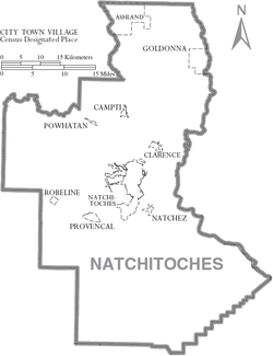
Communities
Villages
|
Natchez, Louisiana Natchez is a village in Natchitoches Parish, Louisiana, United States. The population was 583 at the 2000 census. It is part of the Natchitoches Micropolitan Statistical Area.... Powhatan, Louisiana Powhatan is a village in Natchitoches Parish, Louisiana, United States. The population was 141 at the 2000 census. It is part of the Natchitoches Micropolitan Statistical Area.-Geography:Powhatan is located at... |
Provencal, Louisiana Provencal is a village in Natchitoches Parish, Louisiana, United States. The population was 708 at the 2000 census. It is part of the Natchitoches Micropolitan Statistical Area.-Geography:Provencal is located at .... Robeline, Louisiana Robeline is a village in western Natchitoches Parish, Louisiana, United States. The population was 183 at the 2000 census. It is part of the Natchitoches Micropolitan Statistical Area.... |
Unincorporated areas
|
Cloutierville, Louisiana Cloutierville is an unincorporated community in Natchitoches Parish, Louisiana, United States. It lies about south of the city of Natchitoches on exit 119 at Interstate 49... Marthaville, Louisiana Marthaville is an unincorporated community in Natchitoches Parish, Louisiana, United States. It is part of the Natchitoches Micropolitan Statistical Area.-History:... |
Melrose, Louisiana Melrose is an unincorporated community in Natchitoches Parish, Louisiana, including the Melrose Plantation and surrounding area, on Louisiana Highway 119. In addition to the historic plantation, the Cane River Creole National Historical Park and Heritage Area encompass the Melrose area.Melrose is... Readhimer, Louisiana Readhimer is an unincorporated community in Natchitoches Parish, Louisiana, United States. It is located along Louisiana Highway 9 in far northeastern Natchitoches Parish to the northeast of the parish seat of Natchitoches.... |
Education
Natchitoches Parish School BoardNatchitoches Parish School Board
Natchitoches Parish School Board is a school district headquartered in Natchitoches, Louisiana, United States.It serves Natchitoches Parish.-High schools:* Lakeview High School * Natchitoches Central High School...
operates local public schools.
Several former rural schools, such as Ashland High School
Ashland High School (Ashland, Louisiana)
Ashland High School was a rural public kindergarten-grade 12 primary and secondary educational institution located in the village of Ashland in northern Natchitoches Parish from 1907 until its closing in 1981.-Background:...
and Goldonna High School in the villages of Ashland and Goldonna, have closed over the years under school consolidation.
Major highways
 Interstate 49Interstate 49Interstate 49 is currently an intrastate Interstate Highway located entirely within the state of Louisiana in the southern United States. Its southern terminus is in Lafayette, Louisiana, at Interstate 10 while its northern terminus is in Shreveport, Louisiana, at Interstate 20.-Route...
 U.S. Highway 71
 U.S. Highway 84
 Louisiana Highway 1Louisiana Highway 1Louisiana Highway 1 is a state highway in Louisiana. At 436.20 miles , it is the longest numbered highway of any class in Louisiana. It runs diagonally across the state, connecting the oil and gas fields near the island of Grand Isle with the northwest corner of the state, north of Shreveport.The...
 Louisiana Highway 6Louisiana Highway 6Louisiana Highway 6 is a state highway in Louisiana. It spans and serves Sabine Parish and Natchitoches Parish.-Route description:...
 Louisiana Highway 9Louisiana Highway 9Louisiana Highway 9 is a state highway that serves Natchitoches Parish, Bienville Parish, and Claiborne Parish in north Louisiana. It spans , running a north–south route.-Route description:...
 Louisiana Highway 117
 Louisiana Highway 119
 Louisiana Highway 126
 Louisiana Highway 153
 Louisiana Highway 156
 Louisiana Highway 1226
Adjacent parishes
- Bienville ParishBienville Parish, LouisianaBienville Parish is a parish located in the northwestern portion of the U.S. state of Louisiana. The parish seat is Arcadia and as of the 2000 census, the population is 15,752....
(north) - Winn ParishWinn Parish, LouisianaWinn Parish is a parish located in the U.S. state of Louisiana. Its seat is Winnfield. In 2000, its population was 16,894.The parish has a total area of , of which, of it is land and of it is water....
(northeast) - Grant ParishGrant Parish, Louisiana-Demographics:As of the census of 2000, there were 18,698 people, 7,073 households, and 5,276 families residing in the parish. The population density was 29 people per square mile . There were 8,531 housing units at an average density of 13 per square mile...
(east) - Rapides ParishRapides Parish, Louisiana-Military Installations:*Camp Beauregard *Esler Airfield *England Air Force Base *Camp Claiborne *Camp Livingston -Demographics:...
(southeast) - Vernon ParishVernon Parish, LouisianaVernon Parish is a parish located in the U.S. state of Louisiana. The parish seat is Leesville and as of 2000, the population was 52,531....
(south) - Sabine ParishSabine Parish, LouisianaSabine Parish is a parish located in the U.S. state of Louisiana. The seat of the parish is Many. In 2010, the parish's population was 24,233....
(west) - De Soto ParishDe Soto Parish, Louisiana-Demographics:As of the census of 2010, there were 26,656 people, 9,691 households, and 6,967 families residing in the parish. The population density was 29 people per square mile . There were 11,204 housing units at an average density of 13 per square mile...
(northwest) - Red River ParishRed River Parish, LouisianaRed River Parish is a parish located in the U.S. state of Louisiana. Its seat is Coushatta. It was one of the newer parishes created in 1871 by the state legislature under Reconstruction...
(northwest)
See also: List of counties bordering eight counties
See also
- National Register of Historic Places listings in Natchitoches Parish, LouisianaNational Register of Historic Places listings in Natchitoches Parish, LouisianaThis is a list of the National Register of Historic Places listings in Natchitoches Parish, Louisiana.This is intended to be a complete list of the properties and districts on the National Register of Historic Places in Natchitoches Parish, Louisiana, United States...