

Payne County, Oklahoma
Encyclopedia
Payne County is a county
in the U.S. state
of Oklahoma
. The population as of 2010 was 77,350. Its county seat
is Stillwater
, and the county is named for Capt. David L. Payne
. The county lies northeast of the Oklahoma City metropolitan area
though many consider it an extension of the Oklahoma City metro area due to commuter patterns and other indicators.
(Phase II) was constructed into Payne County.
, the county has a total area of 697 square miles (1,805.2 km²), of which 686 square miles (1,776.7 km²) is land and 11 square miles (28.5 km²) (1.55%) is water.
of 2000, there were 68,190 people, 26,680 households, and 15,314 families residing in the county. The population density
was 99 people per square mile (38/km²). There were 29,326 housing units at an average density of 43 per square mile (16/km²). The racial makeup of the county was 84.33% White
, 3.63% Black
or African American
, 4.58% Native American
, 3.00% Asian
, 0.04% Pacific Islander
, 0.77% from other races
, and 3.64% from two or more races. 2.15% of the population were Hispanic
or Latino
of any race.
There were 26,680 households out of which 25.90% had children under the age of 18 living with them, 45.60% were married couples
living together, 8.30% had a female householder with no husband present, and 42.60% were non-families. 30.10% of all households were made up of individuals and 8.10% had someone living alone who was 65 years of age or older. The average household size was 2.29 and the average family size was 2.90.
In the county, the population was spread out with 19.60% under the age of 18, 25.90% from 18 to 24, 26.20% from 25 to 44, 17.60% from 45 to 64, and 10.80% who were 65 years of age or older. The median age was 28 years. For every 100 females there were 103.30 males. For every 100 females age 18 and over, there were 102.60 males.
The median income for a household in the county was $28,733, and the median income for a family was $40,823. Males had a median income of $31,132 versus $21,113 for females. The per capita income
for the county was $15,983. About 10.80% of families and 20.30% of the population were below the poverty line, including 16.00% of those under age 18 and 8.50% of those age 65 or over.
 Educational entities located in Payne County include:
:
Other landmarks include:
County (United States)
In the United States, a county is a geographic subdivision of a state , usually assigned some governmental authority. The term "county" is used in 48 of the 50 states; Louisiana is divided into parishes and Alaska into boroughs. Parishes and boroughs are called "county-equivalents" by the U.S...
in the U.S. state
U.S. state
A U.S. state is any one of the 50 federated states of the United States of America that share sovereignty with the federal government. Because of this shared sovereignty, an American is a citizen both of the federal entity and of his or her state of domicile. Four states use the official title of...
of Oklahoma
Oklahoma
Oklahoma is a state located in the South Central region of the United States of America. With an estimated 3,751,351 residents as of the 2010 census and a land area of 68,667 square miles , Oklahoma is the 28th most populous and 20th-largest state...
. The population as of 2010 was 77,350. Its county seat
County seat
A county seat is an administrative center, or seat of government, for a county or civil parish. The term is primarily used in the United States....
is Stillwater
Stillwater, Oklahoma
Stillwater is a city in north-central Oklahoma at the intersection of U.S. 177 and State Highway 51. It is the county seat of Payne County, Oklahoma, United States. As of the 2010 census, the city population was 45,688. Stillwater is the principal city of the Stillwater Micropolitan Statistical...
, and the county is named for Capt. David L. Payne
David L. Payne
David Lewis Payne was an American soldier and pioneer. Payne is considered by some to be the "Father of Oklahoma" for his work in opening the state to settlement....
. The county lies northeast of the Oklahoma City metropolitan area
Oklahoma City metropolitan area
-Metro-area suburbs and exurbs:The following communities are suburbs and exurbs of Oklahoma City with populations of at least 1,000 found within the bounds of State Highway 33 to the north, State Highway 18 and US-177 to the east, State Highway 39 and State Highway 9 to the south, and US-81 to the...
though many consider it an extension of the Oklahoma City metro area due to commuter patterns and other indicators.
History
In 2010, the Keystone-Cushing PipelineKeystone Pipeline
The Keystone Pipeline System is a pipeline system to transport synthetic crude oil and diluted bitumen from the Athabasca Oil Sands in northeastern Alberta, Canada to multiple destinations in the United States, which include refineries in Illinois, Cushing oil distribution hub in Oklahoma, and...
(Phase II) was constructed into Payne County.
Geography
According to the U.S. Census BureauUnited States Census Bureau
The United States Census Bureau is the government agency that is responsible for the United States Census. It also gathers other national demographic and economic data...
, the county has a total area of 697 square miles (1,805.2 km²), of which 686 square miles (1,776.7 km²) is land and 11 square miles (28.5 km²) (1.55%) is water.
Adjacent counties
- Noble CountyNoble County, OklahomaNoble County is a county located in the U.S. state of Oklahoma. As of 2010, the population was 11,561. Its county seat is Perry.-21st century:In 2010, the Keystone-Cushing Pipeline was constructed north to south through Noble County....
(north) - Pawnee CountyPawnee County, OklahomaPawnee County is a county located in the U.S. state of Oklahoma. As of 2000, the population was 16,612. Its county seat is Pawnee.-History:The Osage Tribe used the area that contains present day Pawnee County as buffalo hunting grounds...
(northeast) - Creek CountyCreek County, OklahomaCreek County is a county located in the U.S. state of Oklahoma. As of 2010, the population was 69,967. Its county seat is Sapulpa.-Geography:According to the U.S. Census Bureau, the county has a total area of , of which is land and is water....
(east) - Lincoln CountyLincoln County, OklahomaLincoln County is a county located in the U.S. state of Oklahoma. The population as of 2010 was 34,273. It is part of the Oklahoma City Metropolitan Statistical Area.Its county seat is Chandler....
(south) - Logan CountyLogan County, OklahomaLogan County is a county located in the U.S. state of Oklahoma. The population as of 2009 was 39,301. Its county seat is Guthrie. Logan County is part of the Oklahoma City Metropolitan Statistical Area.-Geography:...
(southwest)
Demographics
As of the censusCensus
A census is the procedure of systematically acquiring and recording information about the members of a given population. It is a regularly occurring and official count of a particular population. The term is used mostly in connection with national population and housing censuses; other common...
of 2000, there were 68,190 people, 26,680 households, and 15,314 families residing in the county. The population density
Population density
Population density is a measurement of population per unit area or unit volume. It is frequently applied to living organisms, and particularly to humans...
was 99 people per square mile (38/km²). There were 29,326 housing units at an average density of 43 per square mile (16/km²). The racial makeup of the county was 84.33% White
Race (United States Census)
Race and ethnicity in the United States Census, as defined by the Federal Office of Management and Budget and the United States Census Bureau, are self-identification data items in which residents choose the race or races with which they most closely identify, and indicate whether or not they are...
, 3.63% Black
Race (United States Census)
Race and ethnicity in the United States Census, as defined by the Federal Office of Management and Budget and the United States Census Bureau, are self-identification data items in which residents choose the race or races with which they most closely identify, and indicate whether or not they are...
or African American
Race (United States Census)
Race and ethnicity in the United States Census, as defined by the Federal Office of Management and Budget and the United States Census Bureau, are self-identification data items in which residents choose the race or races with which they most closely identify, and indicate whether or not they are...
, 4.58% Native American
Race (United States Census)
Race and ethnicity in the United States Census, as defined by the Federal Office of Management and Budget and the United States Census Bureau, are self-identification data items in which residents choose the race or races with which they most closely identify, and indicate whether or not they are...
, 3.00% Asian
Race (United States Census)
Race and ethnicity in the United States Census, as defined by the Federal Office of Management and Budget and the United States Census Bureau, are self-identification data items in which residents choose the race or races with which they most closely identify, and indicate whether or not they are...
, 0.04% Pacific Islander
Race (United States Census)
Race and ethnicity in the United States Census, as defined by the Federal Office of Management and Budget and the United States Census Bureau, are self-identification data items in which residents choose the race or races with which they most closely identify, and indicate whether or not they are...
, 0.77% from other races
Race (United States Census)
Race and ethnicity in the United States Census, as defined by the Federal Office of Management and Budget and the United States Census Bureau, are self-identification data items in which residents choose the race or races with which they most closely identify, and indicate whether or not they are...
, and 3.64% from two or more races. 2.15% of the population were Hispanic
Race (United States Census)
Race and ethnicity in the United States Census, as defined by the Federal Office of Management and Budget and the United States Census Bureau, are self-identification data items in which residents choose the race or races with which they most closely identify, and indicate whether or not they are...
or Latino
Race (United States Census)
Race and ethnicity in the United States Census, as defined by the Federal Office of Management and Budget and the United States Census Bureau, are self-identification data items in which residents choose the race or races with which they most closely identify, and indicate whether or not they are...
of any race.
There were 26,680 households out of which 25.90% had children under the age of 18 living with them, 45.60% were married couples
Marriage
Marriage is a social union or legal contract between people that creates kinship. It is an institution in which interpersonal relationships, usually intimate and sexual, are acknowledged in a variety of ways, depending on the culture or subculture in which it is found...
living together, 8.30% had a female householder with no husband present, and 42.60% were non-families. 30.10% of all households were made up of individuals and 8.10% had someone living alone who was 65 years of age or older. The average household size was 2.29 and the average family size was 2.90.
In the county, the population was spread out with 19.60% under the age of 18, 25.90% from 18 to 24, 26.20% from 25 to 44, 17.60% from 45 to 64, and 10.80% who were 65 years of age or older. The median age was 28 years. For every 100 females there were 103.30 males. For every 100 females age 18 and over, there were 102.60 males.
The median income for a household in the county was $28,733, and the median income for a family was $40,823. Males had a median income of $31,132 versus $21,113 for females. The per capita income
Per capita income
Per capita income or income per person is a measure of mean income within an economic aggregate, such as a country or city. It is calculated by taking a measure of all sources of income in the aggregate and dividing it by the total population...
for the county was $15,983. About 10.80% of families and 20.30% of the population were below the poverty line, including 16.00% of those under age 18 and 8.50% of those age 65 or over.
Cities and towns
|
Perkins, Oklahoma Perkins is a city in Payne County, Oklahoma, United States. The population was 2,272 at the 2000 census. The name is derived from Walden Perkins, a congressman who helped establish the local post office. The Iowa Tribe of Oklahoma is headquartered here.... Quay, Oklahoma Quay is an unincorporated community in Pawnee and Payne counties in the U.S. state of Oklahoma. The population was 47 at the 2000 census, at which time it was still a town; the community disincorporated on August 23, 2000.-Geography:... Ripley, Oklahoma Ripley is a town in Payne County, Oklahoma, United States. The population was 444 at the 2000 census.-Geography:Ripley is located at . According to the United States Census Bureau, the town has a total area of , all land.-Demographics:... |
Stillwater, Oklahoma Stillwater is a city in north-central Oklahoma at the intersection of U.S. 177 and State Highway 51. It is the county seat of Payne County, Oklahoma, United States. As of the 2010 census, the city population was 45,688. Stillwater is the principal city of the Stillwater Micropolitan Statistical... Yale, Oklahoma Yale is a city in Payne County, Oklahoma, United States. The population was 1,342 at the 2000 census.-Geography:Yale is located at . According to the United States Census Bureau, the city has a total area of , all land.... |
Education
- Oklahoma Department of Career and Technology Education
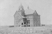
- Oklahoma State University-Stillwater
- Northern Oklahoma CollegeNorthern Oklahoma CollegeNorthern Oklahoma College is a community college located in Tonkawa, Oklahoma, with additional campuses located in Enid, Oklahoma and Stillwater, Oklahoma. Student enrollment is approximately 2,700.-History:...
NRHP sites
The following sites in Payne County are listed on the National Register of Historic PlacesNational Register of Historic Places
The National Register of Historic Places is the United States government's official list of districts, sites, buildings, structures, and objects deemed worthy of preservation...
:
|
Old Central Old Central is the oldest building on the Oklahoma State University campus in Stillwater, Oklahoma. Originally built in 1894, it was the first permanent building on the Oklahoma A&M campus. Old Central's bell clapper once served as a traveling trophy in the Bedlam Series athletics rivalry between... , Oklahoma State University, Stillwater Jim Thorpe House The Jim Thorpe House is in Yale, Oklahoma, located off State Highway 51 at 706 East Boston Street.In 1917, Jim Thorpe bought a small home in Yale, Oklahoma and lived there until 1923 with his wife. The house was bought by the Oklahoma Historical Society in 1968 and is now listed in the National... , Yale |
Other landmarks include:
- Allen Williamson BridgeAllen Williamson BridgeAllen Williamson Bridge is the name of a memorial bridge in Payne County, Oklahoma, named after a former State Representative who served in the Oklahoma State House of Representatives from 1966 - 1974. This politician should not be confused with a similarly named Oklahoma State Senator...
- Memorial bridge near RipleyRipley, OklahomaRipley is a town in Payne County, Oklahoma, United States. The population was 444 at the 2000 census.-Geography:Ripley is located at . According to the United States Census Bureau, the town has a total area of , all land.-Demographics:...
, named after the Oklahoma Representative Allen WilliamsonAllen Williamson (Representative)Allen Williamson is a former Oklahoma politician who served in the Oklahoma House of Representatives from 1966 to 1974. He is related to James Allen Williamson, an Oklahoma State Senator elected in 1996....
.