
Limes Germanicus
Encyclopedia
Limes
A limes was a border defense or delimiting system of Ancient Rome. It marked the boundaries of the Roman Empire.The Latin noun limes had a number of different meanings: a path or balk delimiting fields, a boundary line or marker, any road or path, any channel, such as a stream channel, or any...
) fortifications that bounded the ancient Roman provinces of Germania Inferior
Germania Inferior
Germania Inferior was a Roman province located on the left bank of the Rhine, in today's Luxembourg, southern Netherlands, parts of Belgium, and North Rhine-Westphalia left of the Rhine....
, Germania Superior
Germania Superior
Germania Superior , so called for the reason that it lay upstream of Germania Inferior, was a province of the Roman Empire. It comprised an area of western Switzerland, the French Jura and Alsace regions, and southwestern Germany...
and Raetia
Raetia
Raetia was a province of the Roman Empire, named after the Rhaetian people. It was bounded on the west by the country of the Helvetii, on the east by Noricum, on the north by Vindelicia, on the west by Cisalpine Gaul and on south by Venetia et Histria...
, dividing the Roman Empire
Roman Empire
The Roman Empire was the post-Republican period of the ancient Roman civilization, characterised by an autocratic form of government and large territorial holdings in Europe and around the Mediterranean....
and the unsubdued Germanic tribes from the years 83 to about 260 AD. At its height, the limes stretched from the North Sea outlet of the Rhine to near Regensburg
Regensburg
Regensburg is a city in Bavaria, Germany, located at the confluence of the Danube and Regen rivers, at the northernmost bend in the Danube. To the east lies the Bavarian Forest. Regensburg is the capital of the Bavarian administrative region Upper Palatinate...
on the Danube
Danube
The Danube is a river in the Central Europe and the Europe's second longest river after the Volga. It is classified as an international waterway....
. Those two major rivers afforded natural protection from mass incursions into imperial territory, with the exception of a gap stretching roughly from Mogontiacum (Mainz) on the Rhine to Castra Regina (Regensburg) on the Danube.
The Limes Germanicus was divided into:
- The Lower Germanic Limes, which extended from the North SeaNorth SeaIn the southwest, beyond the Straits of Dover, the North Sea becomes the English Channel connecting to the Atlantic Ocean. In the east, it connects to the Baltic Sea via the Skagerrak and Kattegat, narrow straits that separate Denmark from Norway and Sweden respectively...
at KatwijkKatwijkKatwijk is a coastal municipality and town in the province of South Holland in the western Netherlands. It has a population of 61,292.-Location:...
in the NetherlandsNetherlandsThe Netherlands is a constituent country of the Kingdom of the Netherlands, located mainly in North-West Europe and with several islands in the Caribbean. Mainland Netherlands borders the North Sea to the north and west, Belgium to the south, and Germany to the east, and shares maritime borders...
along the then main Lower RhineLower RhineThe Lower Rhine flows from Bonn, Germany, to the North Sea at Hoek van Holland, Netherlands.Almost immediately after entering the Netherlands, the Rhine splits into many branches. The main branch is called the Waal which flows from Nijmegen to meet the river Meuse; after which it is called Merwede...
branches (modern Oude Rijn, Leidse RijnLeidse RijnThe Leidse Rijn is a canal in the province of Utrecht, Netherlands.It was dug since the Middle Ages when the meandering old Rhine course silted up....
, Kromme RijnKromme RijnThe Kromme Rijn is a river in Utrecht , Netherlands.In Roman times, this northernmost branch of the Rhine delta was the main distributary of this major European river...
, NederrijnNederrijnthumb|left|300px|Course of the NederrijnNederrijn is the name of the Dutch part of the River Rhine from the confluence at the town of Angeren of the cut-off Rhine bend of Oude Rijn and the Pannerdens Kanaal...
) - The Upper Germanic Limes started from the Rhine at RheinbrohlRheinbrohlRheinbrohl is a municipality in the district of Neuwied, in Rhineland-Palatinate, Germany. A reconstructed Roman watchtower marks the beginning of the Germanic limes....
(Neuwied (district)Neuwied (district)Neuwied is a district in the north of Rhineland-Palatinate, Germany. Neighboring districts are Rhein-Sieg, Altenkirchen, Westerwaldkreis, Mayen-Koblenz, Ahrweiler.-History:...
) across the TaunusTaunusThe Taunus is a low mountain range in Hesse, Germany that composes part of the Rhenish Slate Mountains. It is bounded by the river valleys of Rhine, Main and Lahn. On the opposite side of the Rhine, the mountains are continued by the Hunsrück...
mountains to the river Main (East of HanauHanauHanau is a town in the Main-Kinzig-Kreis, in Hesse, Germany. It is located 25 km east of Frankfurt am Main. Its station is a major railway junction.- Geography :...
), then along the Main to MiltenbergMiltenbergMiltenberg is the seat of the like-named district in the Regierungsbezirk of Lower Franconia in Bavaria, Germany.- Location :...
, and from OsterburkenOsterburkenOsterburken is a town in the Neckar-Odenwald district, in Baden-Württemberg, Germany. It is situated 28 km southwest of Tauberbischofsheim, 50 km northeast of Heilbronn, 90 km east of Heidelberg, 60 km southwest of Würzburg and 30 km east of Mosbach...
(Neckar-Odenwald-KreisNeckar-Odenwald-KreisNeckar-Odenwald-Kreis is a district in the north of Baden-Württemberg, Germany. Neighboring districts are Main-Tauber-Kreis, Hohenlohe, Heilbronn, Rhein-Neckar-Kreis, Odenwaldkreis Hesse and Landkreis Miltenberg Bavaria...
) south to LorchLorch (Württemberg)Lorch is a small town situated in the Ostalbkreis district, in Baden-Württemberg, Germany. It is situated on the river Rems, 8 km west of Schwäbisch Gmünd.Friedrich Schiller lived here as a child between 1764 and 1766....
(OstalbkreisOstalbkreisThe Ostalbkreis is a district in the east of Baden-Württemberg, Germany, on the border to Bavaria. Neighboring districts are Schwäbisch Hall, Ansbach, Donau-Ries, Heidenheim, Göppingen and Rems-Murr.-History:...
) in a nearly perfect straight line of more than 70 km; - The proper Rhaetian Limes extended east from Lorch to Eining (close to KelheimKelheimKelheim is a municipality in Bavaria, capital of the district Kelheim. It is situated at the confluence of Altmühl and Danube. As of June 30, 2005, the town had a population of 15,667....
) on the DanubeDanubeThe Danube is a river in the Central Europe and the Europe's second longest river after the Volga. It is classified as an international waterway....
.
The total length was 568 km (352.9 mi). It included at least 60 forts and 900 watchtowers. The potentially weakest, hence most heavily guarded part of the Limes was the gap between the westward bend of the Rhine at modern-day Mainz
Mainz
Mainz under the Holy Roman Empire, and previously was a Roman fort city which commanded the west bank of the Rhine and formed part of the northernmost frontier of the Roman Empire...
and the main flow of the Danube
Danube
The Danube is a river in the Central Europe and the Europe's second longest river after the Volga. It is classified as an international waterway....
at modern-day Regensburg
Regensburg
Regensburg is a city in Bavaria, Germany, located at the confluence of the Danube and Regen rivers, at the northernmost bend in the Danube. To the east lies the Bavarian Forest. Regensburg is the capital of the Bavarian administrative region Upper Palatinate...
. This 300-km wide land corridor between the two great rivers permitted movement of large groups of people without the need for water transport, hence the heavy concentration of forts and towers there, arranged in depth and in multiple layers along waterways, fords, roads, and hilltops.
History
UNESCO
The United Nations Educational, Scientific and Cultural Organization is a specialized agency of the United Nations...
World Heritage Site
World Heritage Site
A UNESCO World Heritage Site is a place that is listed by the UNESCO as of special cultural or physical significance...
s as Frontiers of the Roman Empire. The Saalburg
Saalburg
The Saalburg is a Roman fort located on the Taunus ridge northwest of Bad Homburg, Hesse, Germany. It is a Cohort Fort belonging to the Limes Germanicus, the Roman linear border fortification of the German provinces. The Saalburg, located just off the main road roughly halfway between Bad Homburg...
is a reconstructed fortification and museum of the Limes near Frankfurt
Frankfurt
Frankfurt am Main , commonly known simply as Frankfurt, is the largest city in the German state of Hesse and the fifth-largest city in Germany, with a 2010 population of 688,249. The urban area had an estimated population of 2,300,000 in 2010...
.
Augustus
The first emperor who began to build fortifications along the border was Augustus, shortly after the devastating Roman defeat at the Battle of the Teutoburg ForestBattle of the Teutoburg Forest
The Battle of the Teutoburg Forest took place in 9 CE, when an alliance of Germanic tribes led by Arminius of the Cherusci ambushed and decisively destroyed three Roman legions, along with their auxiliaries, led by Publius Quinctilius Varus.Despite numerous successful campaigns and raids by the...
in 9 AD. Originally there were numerous Limes walls, which were then connected to form the Upper Germanic Limes along the Rhine and the Rhaetian Limes along the Danube. Later these two walls were linked to form a common borderline.
14 to c. 73
From the death of AugustusAugustus
Augustus ;23 September 63 BC – 19 August AD 14) is considered the first emperor of the Roman Empire, which he ruled alone from 27 BC until his death in 14 AD.The dates of his rule are contemporary dates; Augustus lived under two calendars, the Roman Republican until 45 BC, and the Julian...
(14 AD) until after 70 AD, Rome
Rome
Rome is the capital of Italy and the country's largest and most populated city and comune, with over 2.7 million residents in . The city is located in the central-western portion of the Italian Peninsula, on the Tiber River within the Lazio region of Italy.Rome's history spans two and a half...
accepted as her Germanic frontier the water-boundary of the Rhine and upper Danube
Danube
The Danube is a river in the Central Europe and the Europe's second longest river after the Volga. It is classified as an international waterway....
. Beyond these rivers she held only the fertile plain of Frankfurt
Frankfurt
Frankfurt am Main , commonly known simply as Frankfurt, is the largest city in the German state of Hesse and the fifth-largest city in Germany, with a 2010 population of 688,249. The urban area had an estimated population of 2,300,000 in 2010...
, opposite the Roman border fortress of Moguntiacum (Mainz
Mainz
Mainz under the Holy Roman Empire, and previously was a Roman fort city which commanded the west bank of the Rhine and formed part of the northernmost frontier of the Roman Empire...
), the southernmost slopes of the Black Forest
Black Forest
The Black Forest is a wooded mountain range in Baden-Württemberg, southwestern Germany. It is bordered by the Rhine valley to the west and south. The highest peak is the Feldberg with an elevation of 1,493 metres ....
and a few scattered bridge-heads. The northern section of this frontier, where the Rhine is deep and broad, remained the Roman boundary until the empire fell. The southern part was different. The upper Rhine and upper Danube are easily crossed. The frontier which they form is inconveniently long, enclosing an acute-angled wedge of foreign territory between the modern Baden
Baden
Baden is a historical state on the east bank of the Rhine in the southwest of Germany, now the western part of the Baden-Württemberg of Germany....
and Württemberg
Württemberg
Württemberg , formerly known as Wirtemberg or Wurtemberg, is an area and a former state in southwestern Germany, including parts of the regions Swabia and Franconia....
. The Germanic populations of these lands seem in Roman times to have been scanty, and Roman subjects from the modern Alsace-Lorraine
Alsace-Lorraine
The Imperial Territory of Alsace-Lorraine was a territory created by the German Empire in 1871 after it annexed most of Alsace and the Moselle region of Lorraine following its victory in the Franco-Prussian War. The Alsatian part lay in the Rhine Valley on the west bank of the Rhine River and east...
had drifted across the river eastwards. The motives alike of geographical convenience and of the advantages to be gained by recognising these movements of Roman subjects combined to urge a forward policy at Rome, and when the vigorous Vespasian
Vespasian
Vespasian , was Roman Emperor from 69 AD to 79 AD. Vespasian was the founder of the Flavian dynasty, which ruled the Empire for a quarter century. Vespasian was descended from a family of equestrians, who rose into the senatorial rank under the Emperors of the Julio-Claudian dynasty...
had succeeded Nero
Nero
Nero , was Roman Emperor from 54 to 68, and the last in the Julio-Claudian dynasty. Nero was adopted by his great-uncle Claudius to become his heir and successor, and succeeded to the throne in 54 following Claudius' death....
, a series of advances began which gradually closed up the acute angle, or at least rendered it obtuse.
Flavian dynasty
The first advance came about 74 AD, when what is now Baden was invaded and in part annexed and a road carried from the Roman base on the upper Rhine, StraßburgStrasburg
-Places:*Strasbourg, a city in Alsace *Straßburg, Austria, in Carinthia*Strasburg, Germany, Mecklenburg-Western Pomerania*the former name of Brodnica, became Polish after World War I*Strassburg, the German name for Aiud, Alba...
, to the Danube just above Ulm
Ulm
Ulm is a city in the federal German state of Baden-Württemberg, situated on the River Danube. The city, whose population is estimated at 120,000 , forms an urban district of its own and is the administrative seat of the Alb-Donau district. Ulm, founded around 850, is rich in history and...
. The point of the angle was broken off.
The second advance was made by Domitian
Domitian
Domitian was Roman Emperor from 81 to 96. Domitian was the third and last emperor of the Flavian dynasty.Domitian's youth and early career were largely spent in the shadow of his brother Titus, who gained military renown during the First Jewish-Roman War...
about 83 AD. He pushed out from Moguntiacum, extended the Roman territory east of it and enclosed the whole within a systematically delimited and defended frontier with numerous blockhouses along it and larger forts in the rear. Among the blockhouses was one which by various enlargements and refoundations grew into the well-known Saalburg
Saalburg
The Saalburg is a Roman fort located on the Taunus ridge northwest of Bad Homburg, Hesse, Germany. It is a Cohort Fort belonging to the Limes Germanicus, the Roman linear border fortification of the German provinces. The Saalburg, located just off the main road roughly halfway between Bad Homburg...
fort on the Taunus
Taunus
The Taunus is a low mountain range in Hesse, Germany that composes part of the Rhenish Slate Mountains. It is bounded by the river valleys of Rhine, Main and Lahn. On the opposite side of the Rhine, the mountains are continued by the Hunsrück...
near Bad Homburg
Bad Homburg
Bad Homburg vor der Höhe is the district town of the Hochtaunuskreis, Hesse, Germany, on the southern slope of the Taunus, bordering among others Frankfurt am Main and Oberursel...
. This advance necessitated a third movement, the construction of a frontier connecting the annexations of AD 74 and AD 83 . We know the line of this frontier which ran from the Main across the upland Odenwald
Odenwald
The Odenwald is a low mountain range in Hesse, Bavaria and Baden-Württemberg in Germany.- Location :The Odenwald lies between the Upper Rhine Rift Valley with the Bergstraße and the Hessisches Ried in the west, the Main and the Bauland in the east, the Hanau-Seligenstadt Basin – a subbasin of...
to the upper waters of the Neckar
Neckar
The Neckar is a long river, mainly flowing through the southwestern state of Baden-Württemberg, but also a short section through Hesse, in Germany. The Neckar is a major right tributary of the River Rhine...
and was defended by a chain of forts. We do not, however, know its date, save that, if not Domitian's work, it was carried out soon after his death, and the whole frontier thus constituted was reorganised, probably by Hadrian
Hadrian
Hadrian , was Roman Emperor from 117 to 138. He is best known for building Hadrian's Wall, which marked the northern limit of Roman Britain. In Rome, he re-built the Pantheon and constructed the Temple of Venus and Roma. In addition to being emperor, Hadrian was a humanist and was philhellene in...
, with a continuous wooden palisade
Palisade
A palisade is a steel or wooden fence or wall of variable height, usually used as a defensive structure.- Typical construction :Typical construction consisted of small or mid sized tree trunks aligned vertically, with no spacing in between. The trunks were sharpened or pointed at the top, and were...
reaching from Rhine to Danube.
Hadrian and the Antonines
Antoninus Pius
Antoninus Pius , also known as Antoninus, was Roman Emperor from 138 to 161. He was a member of the Nerva-Antonine dynasty and the Aurelii. He did not possess the sobriquet "Pius" until after his accession to the throne...
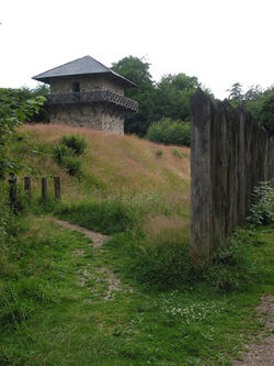
pushed out from the Odenwald and the Danube, and marked out a new frontier roughly parallel to, but in advance of these two lines, though sometimes, as on the Taunus, coinciding with the older line. This is the frontier which is now visible and visited by the curious. It consists, as we see it today, of two distinct frontier works, one, known as the Pfahlgraben, is an earthen mound with stakes on top and ditch in front of the mound, best seen in the neighbourhood of the Saalburg but once extending from the Rhine southwards into southern Germany. The other, which begins where the earthwork stops, is a wall, though not a very formidable wall, of stone, the Teufelsmauer; it runs roughly east and west parallel to the Danube, which it finally joins at Heinheim near Regensburg
Regensburg
Regensburg is a city in Bavaria, Germany, located at the confluence of the Danube and Regen rivers, at the northernmost bend in the Danube. To the east lies the Bavarian Forest. Regensburg is the capital of the Bavarian administrative region Upper Palatinate...
. The southern part of the Pfahlgraben is remarkably straight; for over 50 km it points almost absolutely true for Polaris
Polaris
Polaris |Alpha]] Ursae Minoris, commonly North Star or Pole Star, also Lodestar) is the brightest star in the constellation Ursa Minor. It is very close to the north celestial pole, making it the current northern pole star....
.
Late Roman Empire
Germanic invasions in the late 3rd century led to the abandonment of the so-called "Upper Raetian Limes" in favour of a Roman defence line along the rivers Rhine, IllerIller
The Iller is a river in Bavaria, Germany. It is a right tributary of the Danube, 147 km in length.The source is located near Oberstdorf in the Allgäu region of the Alps, close to the Austrian border. From there it runs northwards, passing the towns of Sonthofen, Immenstadt, and Kempten...
and Danube
Danube
The Danube is a river in the Central Europe and the Europe's second longest river after the Volga. It is classified as an international waterway....
(Donau-Iller-Rhine-Limes). Support was provided to some degree by fast river boats, the navis lusoria
Navis lusoria
A navis lusoria is a type of a small military vessel of the late Roman Empire that served as a troop transport. It was powered by about thirty soldier-oarsmen and an auxiliary sail. Nimble, graceful, and of shallow draft, such a vessel was used on northern rivers close to the Limes Germanicus, the...
being the standard type, that could reach outposts or points of crisis quickly. Watch towers were in sight contact and heavily fortified castra placed at important passes (e.g. Castrum Rauracense instead of the previously unwalled Augusta Raurica
Augusta Raurica
Augusta Raurica is a Roman archaeological site and an open-air museum in Switzerland. Located on the south bank of the Rhine river about 20 km east of Basel near the villages of Augst and Kaiseraugst, it is the oldest known Roman colony on the Rhine....
near to Basel
Basel
Basel or Basle In the national languages of Switzerland the city is also known as Bâle , Basilea and Basilea is Switzerland's third most populous city with about 166,000 inhabitants. Located where the Swiss, French and German borders meet, Basel also has suburbs in France and Germany...
) and in the hinterland of the frontier (e.g. Vindonissa
Vindonissa
Vindonissa was a Roman legion camp at modern Windisch, Switzerland. It was probably established in 15 AD. In an expansion around 30, thermal baths were added....
in today's Switzerland).
Description and functionality of the limes
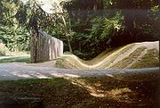
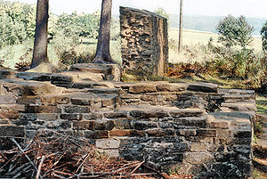
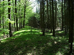
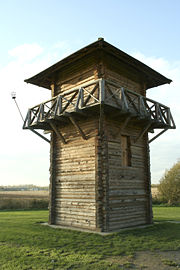
The limes itself is a relatively simple construction. It is similar to the fortification that a travelling troop of Roman soldiers would construct every evening to protect their camp from attacks. On the outside, the soldiers dug a ditch. The earth from the ditch was used to build a mound. On top of the mound stakes were attached. The Limes had a deeper ditch and a higher mound. The stakes were higher too and on several parts of the limes, instead of stakes there was a simple stone wall.Behind the wall/mound a system of control towers, built of wood or stone, was installed, each within sight of the next one, and usually able also to signal to the forts several kilometers to the rear.
.jpg)
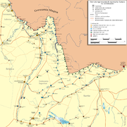
Upper Germanic Limes
Germany:- RheinbrohlRheinbrohlRheinbrohl is a municipality in the district of Neuwied, in Rhineland-Palatinate, Germany. A reconstructed Roman watchtower marks the beginning of the Germanic limes....
– Bad EmsBad EmsBad Ems is a town in Rhineland-Palatinate, Germany. It is the county seat of the Rhein-Lahn rural district and is well known as a bathing resort on the river Lahn...
– MiltenbergMiltenbergMiltenberg is the seat of the like-named district in the Regierungsbezirk of Lower Franconia in Bavaria, Germany.- Location :...
– LorchLorchLorch may refer to:*Lorch, Hesse, a town in Hesse, Germany*Lorch , a town in Baden-Württemberg, Germany*Lorch, Austria, part of Enns in Upper Austria...
– Weißenburg – Eining
Lower Germanic Limes
- XantenXantenXanten is a historic town in the North Rhine-Westphalia state of Germany, located in the district of Wesel.Xanten is known for the Archaeological Park or archaeological open air museum , its medieval picturesque city centre with Xanten Cathedral and many museums, its large man-made lake for...
The Netherlands:
- Nijmegen
- Herwen-De BijlandHerwenHerwen is a village in the Dutch province of Gelderland. It is located in the municipality of Rijnwaarden.Herwen was a separate municipality until 1818, when the area was divided between the new municipality of Herwen en Aerdt and Pannerden.-References:...
- Arnhem-MeinerswijkArnhemArnhem is a city and municipality, situated in the eastern part of the Netherlands. It is the capital of the province of Gelderland and located near the river Nederrijn as well as near the St. Jansbeek, which was the source of the city's development. Arnhem has 146,095 residents as one of the...
- MaurikMaurikMaurik is a town in the Dutch province of Gelderland. It is a part of the municipality of Buren, and lies about 8 km north of Tiel.Maurik was a separate municipality until 1999, when it was merged with Buren....
- VechtenFectioFectio was a Roman castellum in the province Germania Inferior established in the year 4 or 5 AD. It was located at the place where the river Vecht branched off from the Rhine, leading to Lake Flevo, which was later to become the Zuiderzee...
- UtrechtUtrecht (city)Utrecht city and municipality is the capital and most populous city of the Dutch province of Utrecht. It is located in the eastern corner of the Randstad conurbation, and is the fourth largest city of the Netherlands with a population of 312,634 on 1 Jan 2011.Utrecht's ancient city centre features...
- WoerdenWoerdenWoerden is a municipality and a city in the central Netherlands. Due to its central location between Amsterdam, Rotterdam, The Hague and Utrecht, and the fact that it has excellent rail and road connections to those cities, it is a popular town for commuters who work in those cities.-Population...
- ZwammerdamZwammerdamZwammerdam is a town in the Dutch province of South Holland. It is a part of the municipality of Alphen aan den Rijn, and lies about 6 km southeast of Alphen aan de Rijn.In 2001, the town of Zwammerdam had 1709 inhabitants...
- Alphen aan den RijnAlphen aan den RijnAlphen aan den Rijn is a town and municipality in the western Netherlands, in the province of South Holland, between Leiden and Utrecht. The town is situated on the banks of the river Oude Rijn , where the river Gouwe branches off. The municipality had a population of 72,674 in 2010, and covers an...
- Leiden-Roomburg
- ValkenburgValkenburg (South Holland)Valkenburg is a village and former municipality in the province of South Holland, in thewestern Netherlands. Valkenburg is now part of the municipality Katwijk....
- KatwijkKatwijkKatwijk is a coastal municipality and town in the province of South Holland in the western Netherlands. It has a population of 61,292.-Location:...
Secondary sources
- A good English account can be found in H. F. Pelham's essay in Trans. of the Royal Hist. Soc. vol. 20, reprinted in his Collected Papers, pp. 178–211 (Oxford, 1910), where the German authorities are fully cited.
- D.I. Woolliscroft, Roman Military Signalling. Stroud and Charleston: Tempus Publishing, 2001. Pp. 191. ISBN 0-7524-1938-2. A study mainly of intervisibility along the Rhine and British limites.
External links
See also
- DanevirkeDanevirkeThe Danevirke The Danevirke The Danevirke (modern Danish spelling: Dannevirke; in Old Norse Danavirki ; in German Danewerk ; is a system of Danish fortifications in Schleswig-Holstein (Northern Germany). This important linear defensive earthwork was constructed across the neck of the Cimbrian...
- Silesia WallsSilesia WallsSilesia Walls are a line of three parallel earthen ramparts and ditches that run through Lower Silesia in Poland, by the towns Szprotawa and Kożuchów. The walls are about 2.5 metres tall and, at their widest, 47 metres. They run for about 30 kilometres...