
Kromme Rijn
Encyclopedia
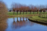
The Kromme Rijn is a river in Utrecht (province)
, Netherlands
.
In Roman
times, this northernmost branch of the Rhine delta
was the main distributary of this major European river. Along its banks the Romans built their frontier castella
part of the Limes Germanicus
.
Since the Middle Ages
, however, the stream lost its importance as it silted up, and eventually it is nearly cut off from the Nederrijn
-Lek
main artery. Yet it retained the name "Rhine".
The Kromme Rijn splits off the Nederrijn-Lek main artery at the old town of Wijk bij Duurstede
(called Dorestad
before medieval times), after which it twists and turns through the province
of Utrecht
, past the towns of Cothen
, Werkhoven
, Odijk and Bunnik
, and ends in the moat
of the city of Utrecht
.
Originally, the city of Utrecht was built by the Romans at a ford (crossing)
near the place where the Kromme Rijn forks into rivers Vecht
(north) and Leidse Rijn
(west); the last stretch within the city walls, however, was channelised to form the Oudegracht
canal
. Rivers Leidse Rijn and Vecht extend from the city moat and are the continuation of the Kromme Rijn.
Utrecht (province)
Utrecht is the smallest province of the Netherlands in terms of area, and is located in the centre of the country. It is bordered by the Eemmeer in the north, Gelderland in the east, the river Rhine in the south, South Holland in the west, and North Holland in the northwest...
, Netherlands
Netherlands
The Netherlands is a constituent country of the Kingdom of the Netherlands, located mainly in North-West Europe and with several islands in the Caribbean. Mainland Netherlands borders the North Sea to the north and west, Belgium to the south, and Germany to the east, and shares maritime borders...
.
In Roman
Ancient Rome
Ancient Rome was a thriving civilization that grew on the Italian Peninsula as early as the 8th century BC. Located along the Mediterranean Sea and centered on the city of Rome, it expanded to one of the largest empires in the ancient world....
times, this northernmost branch of the Rhine delta
River delta
A delta is a landform that is formed at the mouth of a river where that river flows into an ocean, sea, estuary, lake, reservoir, flat arid area, or another river. Deltas are formed from the deposition of the sediment carried by the river as the flow leaves the mouth of the river...
was the main distributary of this major European river. Along its banks the Romans built their frontier castella
Castellum
A castellum is a small Roman detached fort or fortlet used as a watch tower or signal station. The Latin word castellum is a diminutive of castra , which in turn is the plural of castrum ; it is the source of the English word "castle".The term castellum was also used to refer to a settling or...
part of the Limes Germanicus
Limes Germanicus
The Limes Germanicus was a line of frontier fortifications that bounded the ancient Roman provinces of Germania Inferior, Germania Superior and Raetia, dividing the Roman Empire and the unsubdued Germanic tribes from the years 83 to about 260 AD...
.
Since the Middle Ages
Middle Ages
The Middle Ages is a periodization of European history from the 5th century to the 15th century. The Middle Ages follows the fall of the Western Roman Empire in 476 and precedes the Early Modern Era. It is the middle period of a three-period division of Western history: Classic, Medieval and Modern...
, however, the stream lost its importance as it silted up, and eventually it is nearly cut off from the Nederrijn
Nederrijn
thumb|left|300px|Course of the NederrijnNederrijn is the name of the Dutch part of the River Rhine from the confluence at the town of Angeren of the cut-off Rhine bend of Oude Rijn and the Pannerdens Kanaal...
-Lek
Lek River
The Lek is a river in the western Netherlands of some 60 km in length. It is the continuation of the Nederrijn after the Kromme Rijn branches off at the town of Wijk bij Duurstede. The main westbound waterway is hereafter called the Lek River...
main artery. Yet it retained the name "Rhine".
The Kromme Rijn splits off the Nederrijn-Lek main artery at the old town of Wijk bij Duurstede
Wijk bij Duurstede
- The city of Wijk bij Duurstede :The city is located on the Rhine. At Wijk bij Duurstede, the Kromme Rijn branches off, and the main branch is called Lek River downstream from Wijk bij Duurstede....
(called Dorestad
Dorestad
In the Early Middle Ages, Dorestad was the largest settlement of northwestern Europe. It was a large, flourishing trading place, three kilometers long, situated where the rivers Rhine and Lek diverge southeast of Utrecht in the Netherlands near the modern town of Wijk bij Duurstede...
before medieval times), after which it twists and turns through the province
Province
A province is a territorial unit, almost always an administrative division, within a country or state.-Etymology:The English word "province" is attested since about 1330 and derives from the 13th-century Old French "province," which itself comes from the Latin word "provincia," which referred to...
of Utrecht
Utrecht (province)
Utrecht is the smallest province of the Netherlands in terms of area, and is located in the centre of the country. It is bordered by the Eemmeer in the north, Gelderland in the east, the river Rhine in the south, South Holland in the west, and North Holland in the northwest...
, past the towns of Cothen
Cothen
Cothen is a town in the Dutch province of Utrecht. It is a part of the municipality of Wijk bij Duurstede, and lies about 10 km southeast of Houten....
, Werkhoven
Werkhoven
Werkhoven is a town in the Dutch province of Utrecht. It is a part of the municipality of Bunnik, and lies about 5 km east of Houten.In 2001, the town of Werkhoven had 1528 inhabitants. The built-up area of the town was 0.29 km², and contained 550 residences...
, Odijk and Bunnik
Bunnik
Bunnik is a municipality and a village in the Netherlands, in the province of Utrecht. The recorded history of the village dates back nearly 2000 years, when the Romans constructed a fort at Fectio with a harbour facing the river Rhine, which marked the border of the Roman Empire...
, and ends in the moat
Moat
A moat is a deep, broad ditch, either dry or filled with water, that surrounds a castle, other building or town, historically to provide it with a preliminary line of defence. In some places moats evolved into more extensive water defences, including natural or artificial lakes, dams and sluices...
of the city of Utrecht
Utrecht (city)
Utrecht city and municipality is the capital and most populous city of the Dutch province of Utrecht. It is located in the eastern corner of the Randstad conurbation, and is the fourth largest city of the Netherlands with a population of 312,634 on 1 Jan 2011.Utrecht's ancient city centre features...
.
Originally, the city of Utrecht was built by the Romans at a ford (crossing)
Ford (crossing)
A ford is a shallow place with good footing where a river or stream may be crossed by wading or in a vehicle. A ford is mostly a natural phenomenon, in contrast to a low water crossing, which is an artificial bridge that allows crossing a river or stream when water is low.The names of many towns...
near the place where the Kromme Rijn forks into rivers Vecht
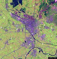
Vecht (Utrecht)
thumb|right|[[Satellite]] [[image]] of the surroundings of [[Utrecht |Utrecht]] showing river Vecht and the [[Amsterdam-Rhine Canal]] .220px|thumb|right|Location of river Vecht ....
(north) and Leidse Rijn
Leidse Rijn
The Leidse Rijn is a canal in the province of Utrecht, Netherlands.It was dug since the Middle Ages when the meandering old Rhine course silted up....
(west); the last stretch within the city walls, however, was channelised to form the Oudegracht
Oudegracht
The Oudegracht, or "old canal", runs through the center of Utrecht, the Netherlands. It starts in the southeast of the city. Here the Kromme Rijn and the Vaartse Rijn arrive to meet the original moat of the fortified town, and the Oudegracht goes from there...
canal
Canal
Canals are man-made channels for water. There are two types of canal:#Waterways: navigable transportation canals used for carrying ships and boats shipping goods and conveying people, further subdivided into two kinds:...
. Rivers Leidse Rijn and Vecht extend from the city moat and are the continuation of the Kromme Rijn.