
Lewes Priory
Encyclopedia
The Priory
of St Pancras was the first Cluniac house in England and had one of the largest monastic churches in the country. It was set within an extensive walled and gated precinct laid out in a commanding location fronting the tidal shore-line at the head of the Ouse
valley to the south of Lewes
in the County of Sussex
. The Priory had daughter houses, including Castle Acre Priory
in Norfolk
, and was endowed with churches and extensive holdings throughout England. In Lewes it had hospitiums dedicated to St James and to St Nicholas.
In 1264, during the Battle of Lewes
, King Henry III
installed his forces in the Priory precinct which came under attack from those of Simon de Montfort
after his victory over Henry in battle. Henry was forced, in the Mise of Lewes, to accept the Council that was the start of Parliamentary government in England.
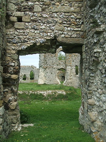
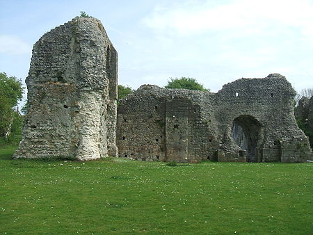
The Priory is a nationally important historical site but an almost lost monument of mediaeval England, the buildings having been systematically demolished after the Dissolution of the Monasteries
in the reign of Henry VIII. Some parts of the lesser buildings survive above ground, fenced off within a public park. The Priory has been the subject of academic and archaeological study since the mid-nineteenth century and a recent Heritage Lottery Fund grant has been awarded for repair of the surviving fabric and to improve public access and interpretation of the site and its history.
and his wife Gundrada, probably in 1081, following their visit to the Priory of Cluny
in Burgundy in 1077. The dedication of the new Priory to St Pancras followed from the presence of a pre-existing Saxon shrine to that Saint on the site. The cult of St Pancras was a strong link between Saxon England and Rome, having been introduced by Augustine in 597 at the behest of Gregory the Great. William de Warenne was acting under the auspices of a Cluniac Pope, Gregory VII
. The ambition of the new work and piety of the new order was intended to legitimise and assert the post-conquest regime in England.
 Existing topographical and built features delineate the Priory precinct. The precinct comprises a rough quadrilateral
of land about 16.1 hectares in area, 520 metres in width, west to east, and 310 metres north to south bounded along the north side by today's Southover High Street and Priory Street. This precinct was comparable in extent to the walled town of Lewes sited on the ridge to the north.
The original context and relationship of the precinct to the natural topography is now far from clear because the tidal valley of the River Ouse to the south has been drained. In the mediaeval period the south side of the precinct addressed the Cockshut Stream and from there a navigable, tidal watercourse connecting to the River Ouse and, hence, the English Channel. The site can properly be understood as a coastal location and was fully enclosed by high flint walls, being vulnerable to sea-borne attack. The Priory buildings were constructed in the western half, the major church and sacred buildings being in the north-west quadrant. The precinct was terraced in section, stepping down to the south with the buildings set at different levels.
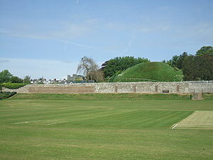 The north-east quadrant has an embankment and wall enclosing its southern side that is of mediaeval date with semicircular buttresses along its eastern extent. This southern wall is a remarkable feature of a defensive, military character. This quadrant is a triple square on plan, the eastern half centres on the conical 'Mount', 150 feet in diameter and 50 feet high that is aligned on a sunken field to its east with banks on all sides known as the 'Dripping Pan'. The ages and original functions of these two man-made features are not certain: they appear to have been built by the Priory and may have been constructed as a salt works on an earlier enclosed. elevated plot. If of mediaeval date or earlier, the Mount would certainly have provided an observatory over the Ouse basin, of defensive importance, and a beacon to shipping navigating across it.
in 1906 based upon archaeology, documented accounts and hypothesis. Aspects of this have been better explored by later research and excavation. The structural bay division shown of the nave is probably wrong, being elongated in a way inconsistent with Romanesque planning modules and different from that of the choir, the Lady Chapel is missing and certain lay buildings are also not shown. This is, nonetheless, the best guide available and a potent diagram.
The buildings accommodated an establishment of around 50 monks at any one time throughout the 12th and 13th centuries as well as lay incumbents and visitors. The precinct buildings were built for sacred and temporal functions and were of ashlar
stone faced chalk and flint core construction. Quarr limestone shipped from the Saxon quarries on the Isle of Wight
was used in the first phase of construction. Caen
limestone, imported from Normandy was used with Sussex marble details for the second phase including the construction of the great church. The Priory had its own masons' yard, it manufactured decorated glazed floor tiles and had a school of sacred painting that worked throughout Sussex. The calibre of surviving figurative carvings that are displayed at the British Museum is of a highly sophisticated order.
 These comprised the cloister and chapter house directly south of the church and the dorter, reredorter
, frater and infirmary to south and east, of which sections survive above ground, as well as the Prior
's lodging and entrance gates to the west of which fragments also survive. The dove house to the south-west was a large building that survived until the early nineteenth century. It is reasonable to assume a pattern of bakeries, fish ponds and other food production and storage buildings in this area of a type and layout identified at Castle Acre and other English Cluniac houses. Subterranean cisterns and drainage courses as well as fresh water conduits have been identified by excavation.
in 1845 constructing the Brighton to Lewes railway through the site of the Priory chapter house. On the floor of the chapel lies the original black Tournai
marble tombstone from the Priory carved to the memory of Gundreda that had been incorporated into a Tudor
period memorial in the church of St Margaret, Isfield.
 The priory was surrendered to the Crown on November 16, 1537 and its destruction carried out at the direction of the King's secretary, Thomas Cromwell. Cromwell appointed a specialist demolition team under an Italian engineer, Giovanni Portinari, who recorded the task and undertook it with exceptional thoroughness. Cromwell leased the site and retained the Prior's lodgings that he extended as a house for his son, known as the Lord's Place. The site of the religious buildings was levelled and laid out as a substantial knot garden
. This was subsequently owned by the Sackville
family whose dwelling survived as Dorset House until its sale in 1668 after which it was demolished.
After 1830, residential development took place to the east of St John’s Church along the northern side of the precinct. This construction cut into the Priory burial grounds, most significantly Regency
Priory Crescent (originally known as "New Crescent"). Despite its grand façade, this collection of houses is somewhat random at the back with a wide range of rear elevations. The individual gardens of Priory Crescent end at a private lane to the south which is linked to the original path connecting the Gatehouse to the Priory. This Gatehouse was rotated 90 degrees and moved just a few metres from its original location in order to widen the road. The current gate is the smaller arch that pedestrians would have walked through, rather than the larger one (used for traffic such as horses and carts). The builders sold the human bones, teeth and skulls that they excavated whilst digging foundations. Priory Street was built in several stages with Mount Street projected southwards in to the Priory precinct.
In 1845, the London, Brighton and Hastings Railway (subsequently the London Brighton and South Coast Railway) drove their new line through the site, digging down to a track bed level to meet the new Lewes railway station (and constructing a line of railway cottages at the east end of Priory Street.
This line bisected the foundations of the chapter house and church apse exposing the foundations and burials including those of William de Warenne and Gundrada. The destruction and collateral damage to the Priory remains was significant and the site was split in two but the construction triggered archaeological investigation. Elements of the fabric and finds are held by the Sussex Archaeological Society in their two Lewes museums and by the British Museum
.
tower and a cottage, made from the stone of the Priory, which were built in the gardens of the former Dorset House. A large metal sculpture of a knight's helm (1964) commemorates the Battle of Lewes
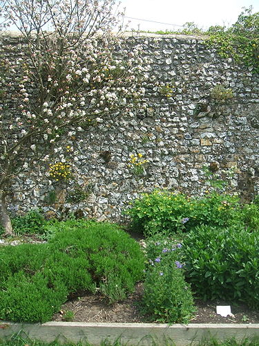
. The herb garden (also known as the Garden for the Blind) of the Priory, recreated by local historians with various plants that would likely have been in the original, is open to the public at all times.
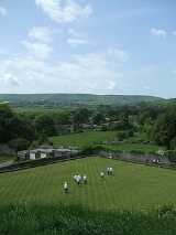
There was once a minigolf course laid out over the challenging slopes of the infirmary, but this, and the public tennis courts, have been closed by the local authority. Much of the Priory precinct is given over to recreation and sports including Lewes Football Club, currently at the Dripping Pan, the Lewes Bowls Club and the Southdowns Sports Club. The Lewes Priory Cricket Club
, formerly at the Dripping Pan, now play at the Stanley Turner Ground, nearby.
A small modern development of relatively simple and attractive housing protrudes east out of Cockshut Road into the precinct. The easternmost of these dwellings overlooks the rear graveyard of St. John's Church, a secluded patch of land including a barn on the site of the original Prior's lodging.
The Priory site to the north of the railway line is in private ownership, formerly occupied by a walled nursery and before that, public gardens, all recently cleared. The standing ruins to the south are separated from the northern site and trapped between the A27 and the railway. Comprehension of the whole from site inspection is difficult and access is limited. The beauty of the situation, referred to by its greatest defender, Walter Godfrey
, and reflected in older engravings is often spoiled by traffic noise.
Ashlar stone from the Priory has been used in many later buildings and walls in Lewes, including Southover Grange and gardens and can be identified on walks around the town. Lewes Priory Cricket Club ground is on an adjacent site and Lewes Priory School, nearby, commemorates this ancient foundation.
Priory
A priory is a house of men or women under religious vows that is headed by a prior or prioress. Priories may be houses of mendicant friars or religious sisters , or monasteries of monks or nuns .The Benedictines and their offshoots , the Premonstratensians, and the...
of St Pancras was the first Cluniac house in England and had one of the largest monastic churches in the country. It was set within an extensive walled and gated precinct laid out in a commanding location fronting the tidal shore-line at the head of the Ouse
River Ouse, Sussex
The River Ouse is a river in the counties of West and East Sussex in England.-Course:The river rises near Lower Beeding and runs eastwards into East Sussex, meandering narrowly and turning slowly southward...
valley to the south of Lewes
Lewes
Lewes is the county town of East Sussex, England and historically of all of Sussex. It is a civil parish and is the centre of the Lewes local government district. The settlement has a history as a bridging point and as a market town, and today as a communications hub and tourist-oriented town...
in the County of Sussex
Sussex
Sussex , from the Old English Sūþsēaxe , is an historic county in South East England corresponding roughly in area to the ancient Kingdom of Sussex. It is bounded on the north by Surrey, east by Kent, south by the English Channel, and west by Hampshire, and is divided for local government into West...
. The Priory had daughter houses, including Castle Acre Priory
Castle Acre Priory
Castle Acre Priory, in the village of Castle Acre, Norfolk, England, is thought to have been founded in 1089 by William de Warenne the son the 1st Earl of Surrey who had founded England's first Cluniac priory at Lewes in 1077. The order originated from Burgundy...
in Norfolk
Norfolk
Norfolk is a low-lying county in the East of England. It has borders with Lincolnshire to the west, Cambridgeshire to the west and southwest and Suffolk to the south. Its northern and eastern boundaries are the North Sea coast and to the north-west the county is bordered by The Wash. The county...
, and was endowed with churches and extensive holdings throughout England. In Lewes it had hospitiums dedicated to St James and to St Nicholas.
In 1264, during the Battle of Lewes
Battle of Lewes
The Battle of Lewes was one of two main battles of the conflict known as the Second Barons' War. It took place at Lewes in Sussex, on 14 May 1264...
, King Henry III
Henry III of England
Henry III was the son and successor of John as King of England, reigning for 56 years from 1216 until his death. His contemporaries knew him as Henry of Winchester. He was the first child king in England since the reign of Æthelred the Unready...
installed his forces in the Priory precinct which came under attack from those of Simon de Montfort
Simon de Montfort, 6th Earl of Leicester
Simon de Montfort, 6th Earl of Leicester, 1st Earl of Chester , sometimes referred to as Simon V de Montfort to distinguish him from other Simon de Montforts, was an Anglo-Norman nobleman. He led the barons' rebellion against King Henry III of England during the Second Barons' War of 1263-4, and...
after his victory over Henry in battle. Henry was forced, in the Mise of Lewes, to accept the Council that was the start of Parliamentary government in England.
The Priory is a nationally important historical site but an almost lost monument of mediaeval England, the buildings having been systematically demolished after the Dissolution of the Monasteries
Dissolution of the Monasteries
The Dissolution of the Monasteries, sometimes referred to as the Suppression of the Monasteries, was the set of administrative and legal processes between 1536 and 1541 by which Henry VIII disbanded monasteries, priories, convents and friaries in England, Wales and Ireland; appropriated their...
in the reign of Henry VIII. Some parts of the lesser buildings survive above ground, fenced off within a public park. The Priory has been the subject of academic and archaeological study since the mid-nineteenth century and a recent Heritage Lottery Fund grant has been awarded for repair of the surviving fabric and to improve public access and interpretation of the site and its history.
Foundation
Lewes Priory was founded by William de Warenne, 1st Earl of SurreyWilliam de Warenne, 1st Earl of Surrey
William de Warenne, 1st Earl of Surrey, Seigneur de Varennes is one of the very few proven Companions of William the Conqueror known to have fought at the Battle of Hastings in 1066...
and his wife Gundrada, probably in 1081, following their visit to the Priory of Cluny
Cluny
Cluny or Clungy is a commune in the Saône-et-Loire department in the region of Bourgogne in eastern France. It is 20 km northwest of Mâcon.The town grew up around the Benedictine Cluny Abbey, founded by Duke William I of Aquitaine in 910...
in Burgundy in 1077. The dedication of the new Priory to St Pancras followed from the presence of a pre-existing Saxon shrine to that Saint on the site. The cult of St Pancras was a strong link between Saxon England and Rome, having been introduced by Augustine in 597 at the behest of Gregory the Great. William de Warenne was acting under the auspices of a Cluniac Pope, Gregory VII
Pope Gregory VII
Pope St. Gregory VII , born Hildebrand of Sovana , was Pope from April 22, 1073, until his death. One of the great reforming popes, he is perhaps best known for the part he played in the Investiture Controversy, his dispute with Henry IV, Holy Roman Emperor affirming the primacy of the papal...
. The ambition of the new work and piety of the new order was intended to legitimise and assert the post-conquest regime in England.
The site
Quadrilateral
In Euclidean plane geometry, a quadrilateral is a polygon with four sides and four vertices or corners. Sometimes, the term quadrangle is used, by analogy with triangle, and sometimes tetragon for consistency with pentagon , hexagon and so on...
of land about 16.1 hectares in area, 520 metres in width, west to east, and 310 metres north to south bounded along the north side by today's Southover High Street and Priory Street. This precinct was comparable in extent to the walled town of Lewes sited on the ridge to the north.
The original context and relationship of the precinct to the natural topography is now far from clear because the tidal valley of the River Ouse to the south has been drained. In the mediaeval period the south side of the precinct addressed the Cockshut Stream and from there a navigable, tidal watercourse connecting to the River Ouse and, hence, the English Channel. The site can properly be understood as a coastal location and was fully enclosed by high flint walls, being vulnerable to sea-borne attack. The Priory buildings were constructed in the western half, the major church and sacred buildings being in the north-west quadrant. The precinct was terraced in section, stepping down to the south with the buildings set at different levels.
The buildings
Modern understanding of the layout and development of the Priory derives largely from archaeological excavations carried out since the 1840s, most extensively by George Somers Clarke. The accepted plan of the Priory was drawn by archaeologist and antiquary Sir William Henry St.John Hope and architect Sir Harold BrakspearHarold Brakspear
Sir Harold William Brakspear was a noted restoration architect and archaeologist.He restored a number of ancient and notable buildings, including*Bath Abbey*Windsor Castle*Brownston House, Devizes....
in 1906 based upon archaeology, documented accounts and hypothesis. Aspects of this have been better explored by later research and excavation. The structural bay division shown of the nave is probably wrong, being elongated in a way inconsistent with Romanesque planning modules and different from that of the choir, the Lady Chapel is missing and certain lay buildings are also not shown. This is, nonetheless, the best guide available and a potent diagram.
The buildings accommodated an establishment of around 50 monks at any one time throughout the 12th and 13th centuries as well as lay incumbents and visitors. The precinct buildings were built for sacred and temporal functions and were of ashlar
Ashlar
Ashlar is prepared stone work of any type of stone. Masonry using such stones laid in parallel courses is known as ashlar masonry, whereas masonry using irregularly shaped stones is known as rubble masonry. Ashlar blocks are rectangular cuboid blocks that are masonry sculpted to have square edges...
stone faced chalk and flint core construction. Quarr limestone shipped from the Saxon quarries on the Isle of Wight
Isle of Wight
The Isle of Wight is a county and the largest island of England, located in the English Channel, on average about 2–4 miles off the south coast of the county of Hampshire, separated from the mainland by a strait called the Solent...
was used in the first phase of construction. Caen
Caen
Caen is a commune in northwestern France. It is the prefecture of the Calvados department and the capital of the Basse-Normandie region. It is located inland from the English Channel....
limestone, imported from Normandy was used with Sussex marble details for the second phase including the construction of the great church. The Priory had its own masons' yard, it manufactured decorated glazed floor tiles and had a school of sacred painting that worked throughout Sussex. The calibre of surviving figurative carvings that are displayed at the British Museum is of a highly sophisticated order.
The Great Church of St Pancras
The first Cluniac Priory church was a reconstruction in stone of a Saxon timber church. This may correspond to the single cell structure of which the lower sections of wall and the altar survive, now known as the Infirmary Chapel. This is orientated to a different liturgical east from the major church (which is 5.5 degrees closer to current magnetic east) but the same orientation as that of St Michael, Lewes, also a Saxon foundation and, interestingly, of St John, Southover. By the twelfth century it had become the practice to orient a church to face the rising sun on the day of the saint in whose name the church was dedicated, in this case, 12 May, to which orientation the major church appears to have been aligned. The major church was constructed after 1140 AD with the west towers recorded as unfinished in 1268 AD. Of this work nothing survives above ground level. The design of the church was based upon that of its mother church at Cluny, then the largest church in the world, now referred to as Cluny III. Comparison with the surviving Romanesque fabric of the daughter Priory of Castle Acre is relevant. The church had an internal length of 420 feet from west door to chancel apse, with an internal vault height of 93 feet at the altar and 105 feet at the crossing. This was the largest church in Sussex, being longer than Chichester Cathedral including its Lady Chapel, and is comparable in scale to the original form of Ely Cathedral or the surviving form of Lichfield Cathedral.The priory buildings
Reredorter
The reredorter was a communal toilet found in mediaeval monasteries in Western Europe and later also in some New World monasteries. It was normally attached to the south end or the east side of the monks' dormitory on the east of the main cloister with seats arranged on the first floor of the...
, frater and infirmary to south and east, of which sections survive above ground, as well as the Prior
Prior
Prior is an ecclesiastical title, derived from the Latin adjective for 'earlier, first', with several notable uses.-Monastic superiors:A Prior is a monastic superior, usually lower in rank than an Abbot. In the Rule of St...
's lodging and entrance gates to the west of which fragments also survive. The dove house to the south-west was a large building that survived until the early nineteenth century. It is reasonable to assume a pattern of bakeries, fish ponds and other food production and storage buildings in this area of a type and layout identified at Castle Acre and other English Cluniac houses. Subterranean cisterns and drainage courses as well as fresh water conduits have been identified by excavation.
The Hospitium, now St John the Baptist, Southover
This church incorporates the original hospitium. The twelfth century nave arcade, with short drum piers and un-moulded arches perhaps divided the men's from the women's ward. The neo-Norman south chapel of 1847 houses the bones of William and Gundrada de Warenne unearthed in two lead cists by railway navviesNavvy
Navvy is a shorter form of navigator or navigational engineer and is particularly applied to describe the manual labourers working on major civil engineering projects...
in 1845 constructing the Brighton to Lewes railway through the site of the Priory chapter house. On the floor of the chapel lies the original black Tournai
Tournai
Tournai is a Walloon city and municipality of Belgium located 85 kilometres southwest of Brussels, on the river Scheldt, in the province of Hainaut....
marble tombstone from the Priory carved to the memory of Gundreda that had been incorporated into a Tudor
Tudor dynasty
The Tudor dynasty or House of Tudor was a European royal house of Welsh origin that ruled the Kingdom of England and its realms, including the Lordship of Ireland, later the Kingdom of Ireland, from 1485 until 1603. Its first monarch was Henry Tudor, a descendant through his mother of a legitimised...
period memorial in the church of St Margaret, Isfield.
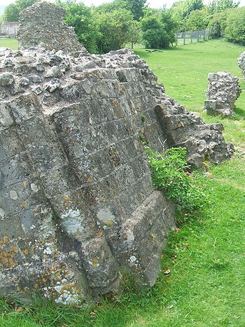
The precinct walls
The most extensive surviving mediaeval structures are the precinct walls along the north (140 metres) and east (170 metres) sides of the Dripping Pan. Lengths also survive down Cockshut Road bounding the west side of the precinct. Significant secondary walls within the great precinct sub divide the land, notably the south wall of the Dripping Pan. The precinct walls have otherwise generally been removed for housing development, the railway and a car park near the Mount. Fragments of the Great Gate (circa. 1200 AD) exist in a rearranged form adjacent to the east end of St John’s Church. The destruction of the walls has continued in recent years following the grant of Planning Permission by Lewes District Council to Lewes Football Club to demolish a section of the longest surviving extent of the structure along Ham Lane in 2006 for unrealised business objectives whilst a further adjacent length subsequently delaminated and fell in 2008 with repairs started in late 2009.Dissolution and destruction
Knot garden
A knot garden is a garden of very formal design in a square frame, consisting of a variety of aromatic plants and culinary herbs including germander, marjoram, thyme, southernwood, lemon balm, hyssop, costmary, acanthus, mallow, chamomile, rosemary, Calendulas, Violas and Santolina...
. This was subsequently owned by the Sackville
Sackville
-People:*Baron Sackville**Lionel Edward Sackville-West, 3rd Baron Sackville**Victoria Sackville-West, Baroness Sackville**Edward Sackville-West, 5th Baron Sackville , writer and musicologist* Viscount Sackville...
family whose dwelling survived as Dorset House until its sale in 1668 after which it was demolished.
After 1830, residential development took place to the east of St John’s Church along the northern side of the precinct. This construction cut into the Priory burial grounds, most significantly Regency
Regency architecture
The Regency style of architecture refers primarily to buildings built in Britain during the period in the early 19th century when George IV was Prince Regent, and also to later buildings following the same style...
Priory Crescent (originally known as "New Crescent"). Despite its grand façade, this collection of houses is somewhat random at the back with a wide range of rear elevations. The individual gardens of Priory Crescent end at a private lane to the south which is linked to the original path connecting the Gatehouse to the Priory. This Gatehouse was rotated 90 degrees and moved just a few metres from its original location in order to widen the road. The current gate is the smaller arch that pedestrians would have walked through, rather than the larger one (used for traffic such as horses and carts). The builders sold the human bones, teeth and skulls that they excavated whilst digging foundations. Priory Street was built in several stages with Mount Street projected southwards in to the Priory precinct.
In 1845, the London, Brighton and Hastings Railway (subsequently the London Brighton and South Coast Railway) drove their new line through the site, digging down to a track bed level to meet the new Lewes railway station (and constructing a line of railway cottages at the east end of Priory Street.
This line bisected the foundations of the chapter house and church apse exposing the foundations and burials including those of William de Warenne and Gundrada. The destruction and collateral damage to the Priory remains was significant and the site was split in two but the construction triggered archaeological investigation. Elements of the fabric and finds are held by the Sussex Archaeological Society in their two Lewes museums and by the British Museum
British Museum
The British Museum is a museum of human history and culture in London. Its collections, which number more than seven million objects, are amongst the largest and most comprehensive in the world and originate from all continents, illustrating and documenting the story of human culture from its...
.
Present situation
Despite the disruption caused by the construction of the railway across the site, a substantial protected ruin still stands within parkland, albeit only a small proportion of the original priory building fabric. In the nineteenth and early twentieth centuries, the ruins were subject of research and conservation and a popular visitor attraction, but are now fenced off to the public, for preservation. They are set in public grounds known as Priory Fields which are open to the public but peripheral to the town. In the park there are two neo-medieval buildings, a follyFolly
In architecture, a folly is a building constructed primarily for decoration, but either suggesting by its appearance some other purpose, or merely so extravagant that it transcends the normal range of garden ornaments or other class of building to which it belongs...
tower and a cottage, made from the stone of the Priory, which were built in the gardens of the former Dorset House. A large metal sculpture of a knight's helm (1964) commemorates the Battle of Lewes
Battle of Lewes
The Battle of Lewes was one of two main battles of the conflict known as the Second Barons' War. It took place at Lewes in Sussex, on 14 May 1264...
. The herb garden (also known as the Garden for the Blind) of the Priory, recreated by local historians with various plants that would likely have been in the original, is open to the public at all times.
There was once a minigolf course laid out over the challenging slopes of the infirmary, but this, and the public tennis courts, have been closed by the local authority. Much of the Priory precinct is given over to recreation and sports including Lewes Football Club, currently at the Dripping Pan, the Lewes Bowls Club and the Southdowns Sports Club. The Lewes Priory Cricket Club
Lewes Priory Cricket Club
Lewes Priory is a cricket club based in Lewes, England. The club is based at the Stanley Turner Ground, although the Saturday 3rd XI plays at the Convent Field, which is situated behind Lewes F.C.'s The Dripping Pan ground. The Saturday 1st XI plays in the 2nd division of the Sussex Cricket League....
, formerly at the Dripping Pan, now play at the Stanley Turner Ground, nearby.
A small modern development of relatively simple and attractive housing protrudes east out of Cockshut Road into the precinct. The easternmost of these dwellings overlooks the rear graveyard of St. John's Church, a secluded patch of land including a barn on the site of the original Prior's lodging.
The Priory site to the north of the railway line is in private ownership, formerly occupied by a walled nursery and before that, public gardens, all recently cleared. The standing ruins to the south are separated from the northern site and trapped between the A27 and the railway. Comprehension of the whole from site inspection is difficult and access is limited. The beauty of the situation, referred to by its greatest defender, Walter Godfrey
Walter Godfrey
Walter Hindes Godfrey CBE, FSA, FRIBA , was an English architect, antiquary, and architectural and topographical historian. He was also a landscape architect and designer, and an accomplished draftsman and illustrator...
, and reflected in older engravings is often spoiled by traffic noise.
Ashlar stone from the Priory has been used in many later buildings and walls in Lewes, including Southover Grange and gardens and can be identified on walks around the town. Lewes Priory Cricket Club ground is on an adjacent site and Lewes Priory School, nearby, commemorates this ancient foundation.