
Pennsylvania Route 65
Encyclopedia
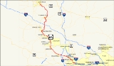
Pennsylvania Route 65 is a major 51 miles (82.1 km) state highway located in western Pennsylvania
, United States. The route, traveling north–south from the Interstate 279
/U.S. Route 19 Truck
(I-279/US 19 Truck) concurrency
in Pittsburgh
north to the PA 108
/PA 168
concurrency in New Castle
, connects downtown Pittsburgh to the northwestern portion of the Pittsburgh Metropolitan Area. PA 65 is similar in its purpose to PA 18
and PA 51
, both of which run parallel to PA 65 at one point or another; however, the three routes pass through different cities for most of their respective alignments.
The route begins in the Golden Triangle of Pittsburgh as a limited-access highway, following the bank of the Allegheny
and Ohio
rivers around the Manchester neighborhood, passing north of Heinz Field
and west of PNC Park
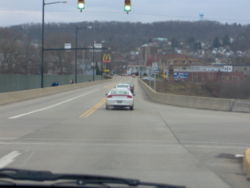
. While limited-access, the road becomes Ohio River Boulevard, named for the river that PA 65 parallels for 25 miles (40.2 km) between the city of Pittsburgh and the borough of Rochester
. Outside of the city, the road becomes a four-lane at-grade roadway to Rochester, with some portions featuring a divided highway
. North of Rochester, PA 65 narrows to two lanes and passes through predominantly rural land, running concurrent with PA 18
and PA 288
as it heads north.
In Pittsburgh, the boulevard was one of the deadliest roads in the city from the 1970s to the early 1980s.
The entire length of PA 65 is named the 65th Infantry Division Memorial Highway after the 65th Infantry Division of the United States Army
.
at the I-279/US 19 Truck concurrency near downtown Pittsburgh. Long ramps stretch from exit 7A on I-279 north of the Fort Duquesne Bridge
. PA 65 starts as a limited-access highway known as the "Ohio River Boulevard". This was the site of many deadly accidents during the 1970s. The following exit is called "North Shore
" and is located only on PA 65 northbound. This exit is the primary entrance to Heinz Field
(home to the Steelers
) and it is also a way for drivers to get to PNC Park
(home to the Pirates
).
On the following exit, PA 65 makes a loop to the north and begins a concurrency with US
at a diamond interchange
just north of the West End Bridge. The following two exits (one northbound and another southbound) ends the concurrency between US 19 and PA 65. Beyond US 19, PA 65 returns to at-grade level as a divided highway
through the western sections of Pittsburgh. At mile marker 2.9 near the Pittsburgh city line, PA 65 intersects the Blue Belt which crosses the Ohio River to the southwest on the McKees Rocks Bridge.
 Outside of Pittsburgh, PA 65 continues as the Ohio River Boulevard on its northwest course and passes through the following boroughs paralleling the Ohio River: Bellevue
, Avalon
, Ben Avon, and Emsworth
. In Emsworth, PA 65 intersects the first terminus of the Green Belt at an intersection with Camp Horne Road. Upon exiting Emsworth, PA 65 returns to a divided highway and interchanges with I-79
and the Yellow Belt at exit 66 in the borough of Glenfield
.
West of I-79, PA 65 continues to parallel the Ohio River located to the south. Along the way, PA 65 passes through some boroughs like Haysville
and Osborne
. In the borough of Sewickley
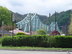
, PA 65 meets the long Orange Belt at Broad Street which crosses the Ohio River on the Sewickley Bridge
and has direct access to PA 51. Leaving Sewickley, PA 65 crosses two more broughs (Edgeworth
and Leetsdale
) before exiting Allegheny County
. In Leetsdale, PA 65 meets the first terminus of the Red Belt at an intersection involving Cross Street.
 Leaving Allegheny County and entering Beaver County
, PA 65 traverses the borough of Ambridge
. In Ambridge, PA 65 intersects the southern terminus of PA 989
. When exiting Ambridge, PA 65 travels to the north paralleling the Ohio River as a divided road as it passes through Baden
. In East Rochester
, PA 65 follows a concurrency with PA 51, while in Rochester
, PA 51/PA 65 intersects PA 18
. At mile marker 25.1 in downtown Rochester, a major four-route interchange takes place where PA 51 joins PA 68
and PA 65 continues to the north. In Rochester Township, PA 65 begins a concurrency with PA 18 as it enters the northbound lanes of PA 65 and exits on the southbound lanes.
PA 18/PA 65 continue northward paralleling the Beaver River
. In New Brighton
, the PA 18/PA 65 concurrency ends when PA 65 makes a 90-degree-angle turn towards the northeast as 5th Street. After a couple of wide turns, PA 65 becomes Mercer Avenue later becoming Mercer Road outside of New Brighton. In North Sewickley Township
, PA 65 intersects PA 588
then passes over I-76
(Pennsylvania Turnpike
). East of Ellwood City
, PA 65 begins another concurrency with PA 288
into Ellwood City. On the south side of Ellwood City, PA 65/PA 288 curve to the north as 2nd Street.
just north of the Beaver
–Lawrence
county line. North of PA 351, PA 65/PA 288 meet the western terminus of PA 488
; at that junction, PA 65/PA 288 make a 90-degree-angle turn to the west and another turn to the north. After crossing the Connoquenessing Creek
, the PA 65/PA 288 concurrency comes to an end while PA 65 travels north as North Street, then turns to the east to become Line Avenue, and then shifts towards the north as New Castle Road then becoming Ellwood Road.
In Shenango Township
, PA 65 intersects the southern terminus of PA 388
at a "Y" intersection. South of New Castle
, PA 65 interchanges with US 422
. PA 65 enters the city of New Castle as East Washington Street traveling on a northwest course. At mile marker 50.8, PA 65 intersects US 422 Business which was the former northern terminus of PA 65 until February 2007. In downtown New Castle, PA 65 terminates at an intersection with PA 108
and PA 168
both signed as Croton Avenue.
alignment between Oil City
and Ohio
from 1928 to 1932. PA 65 was under construction from Mercer
to Valley Road in 1928 and completed the following year.
In 1961, PA 65 was signed in its current location replacing the previous PA 88
designation. In 1965, a median
was installed between Freedom
and Rochester
.
In January 1970, construction began on the next section of Ohio River Boulevard from near the California Avenue/Marshall Avenue intersection to Pennsylvania Avenue. In 1973, a $16 million section opened to traffic with plans to continue the expressway to the Fort Duquesne Bridge
.
In spring 1987, construction on the $8 million Phase One project to connect the two sections of Ohio River Boulevard together began from Western Avenue to Allegheny Avenue. In January 1988, Phase Two of the project began, which consisted of a new interchange between the expressway and the West End Bridge. The bridge would be closed for two years while it underwent rehabilitation and new ramps were built at the northern end for the interchange. The southern terminus was moved from Western Avenue to I-279 when the missing section in Ohio River Boulevard was finally completed in 1992.
) retained the PA 88 badging. This was done because the New Castle–Pittsburgh portion was dedicated to the 65th Infantry Division, and the number was changed in honor of that unit.
Although it has been nearly half a century since the redesignation was done, remnants of PA 65 being once part of PA 88 still show in the area. Four of PA 88's five spur routes (PA 288
, PA 388
, PA 488
, and PA 588
) are now spur routes of PA 65, but still retain the "88" base numbers. In addition, a drive-in theater
known as Spotlight 88 in North Sewickley Township
retained its name after the route was redesignated, and is still known by that name as its current incarnation as a flea market
after the drive-in was destroyed by an F3 tornado on May 31, 1985.
. The highway would be 40 feet (12.2 m) wide and have many bridges over local roads. It would end at a traffic circle
on the North Shore of the Ohio River at the McKees Rocks Bridge. The route that was built to relieve traffic and accidents on California Avenue was dedicated in August 1931 at a final cost of $12 million.
As traffic on boulevard began to increase in the 1950s and 1960s, many plans were introduced to improve the highway. Ideas ranged from widening the highway to building a new expressway to current day I-79. During the 1960s, a southern extension of the boulevard to Pittsburgh's North Side was discussed and by 1973 the highway opened from the Fort Duquesne Bridge to Ridge Avenue and the McKees Rocks Bridge to Beaver Avenue and Chateau Street. Many of these proposals would fall to the wayside because of lack of funding and interest or community protest. The missing gap which includes a connection to the West End Bridge did not open until January 1992.
By the 1970s, the Ohio River Boulevard section of PA 65 had become a deadly trail. By the mid 1970s, The boulevard became one of Pittsburgh's most dangerous roads. From November 7, 1979 to March 1981, 15 people were killed on the boulevard, eight of those deaths occurring between the McKees Rocks Bridge and Manchester. The deadliest time was in 1980 when seven people were killed on the boulevard.
Pennsylvania
The Commonwealth of Pennsylvania is a U.S. state that is located in the Northeastern and Mid-Atlantic regions of the United States. The state borders Delaware and Maryland to the south, West Virginia to the southwest, Ohio to the west, New York and Ontario, Canada, to the north, and New Jersey to...
, United States. The route, traveling north–south from the Interstate 279
Interstate 279
Interstate 279 is a north–south Interstate Highway spur that lies entirely within Allegheny County, Pennsylvania. Its southern end is at Interstate 376 at the Fort Pitt Bridge in Pittsburgh, and the north end is in Franklin Park at Interstate 79...
/U.S. Route 19 Truck
U.S. Route 19 Truck (Pittsburgh, Pennsylvania)
U.S. Route 19 Truck is a truck route route of U.S. Route 19 located in Western Pennsylvania in the Pittsburgh Metro Area that has a length of . It is a loop off US 19; the southern terminus located in Mt. Lebanon and the northern terminus in McCandless Township, connecting to US 19 at both ends...
(I-279/US 19 Truck) concurrency
Concurrency (road)
A concurrency, overlap, or coincidence in a road network is an instance of one physical road bearing two or more different highway, motorway, or other route numbers...
in Pittsburgh
Pittsburgh, Pennsylvania
Pittsburgh is the second-largest city in the US Commonwealth of Pennsylvania and the county seat of Allegheny County. Regionally, it anchors the largest urban area of Appalachia and the Ohio River Valley, and nationally, it is the 22nd-largest urban area in the United States...
north to the PA 108
Pennsylvania Route 108
Pennsylvania Route 108 is a highway in Western Pennsylvania that runs for from the Ohio state line near SNPJ to Pennsylvania Route 8 in Adams Corner. PA 108 intersects US Route 422 in New Castle and US Route 19 near Harlansburg...
/PA 168
Pennsylvania Route 168
Pennsylvania Route 168 is a highway in Western Pennsylvania that runs for from Pennsylvania Route 18 in Frankfort Springs to Pennsylvania Route 208 in Volant...
concurrency in New Castle
New Castle, Pennsylvania
New Castle is a city in Lawrence County, Pennsylvania, United States, northwest of Pittsburgh and near the Pennsylvania-Ohio border just east of Youngstown, Ohio; in 1910, the total population was 36,280; in 1920, 44,938; and in 1940, 47,638. The population has fallen to 26,309 according to the...
, connects downtown Pittsburgh to the northwestern portion of the Pittsburgh Metropolitan Area. PA 65 is similar in its purpose to PA 18
Pennsylvania Route 18
Pennsylvania Route 18 is a major north–south highway in Western Pennsylvania whose southern terminus is at the West Virginia state line in Greene County, Pennsylvania near the village of Garrison, while the northern terminus is at PA Route 5 in Lake City, Pennsylvania...
and PA 51
Pennsylvania Route 51
Pennsylvania Route 51 is a major state highway in Western Pennsylvania. It runs for from Uniontown to the Ohio state line near Darlington, where it connects with Ohio State Route 14. Route 51 is the termination point for Pennsylvania Route 43, Pennsylvania Route 48 and Pennsylvania Route 88. ...
, both of which run parallel to PA 65 at one point or another; however, the three routes pass through different cities for most of their respective alignments.
The route begins in the Golden Triangle of Pittsburgh as a limited-access highway, following the bank of the Allegheny
Allegheny River
The Allegheny River is a principal tributary of the Ohio River; it is located in the Eastern United States. The Allegheny River joins with the Monongahela River to form the Ohio River at the "Point" of Point State Park in Downtown Pittsburgh, Pennsylvania...
and Ohio
Ohio River
The Ohio River is the largest tributary, by volume, of the Mississippi River. At the confluence, the Ohio is even bigger than the Mississippi and, thus, is hydrologically the main stream of the whole river system, including the Allegheny River further upstream...
rivers around the Manchester neighborhood, passing north of Heinz Field
Heinz Field
Heinz Field is a stadium located in Pittsburgh, Pennsylvania. It primarily serves as the home to the Pittsburgh Steelers and University of Pittsburgh Panthers American football teams, members of the National Football League and National Collegiate Athletic Association respectively...
and west of PNC Park
PNC Park
PNC Park is a baseball park located in Pittsburgh, Pennsylvania. It is the fifth home of the Pittsburgh Pirates, the city's Major League Baseball franchise. It opened during the 2001 Major League Baseball season, after the controlled implosion of the Pirates' previous home, Three Rivers Stadium...
. While limited-access, the road becomes Ohio River Boulevard, named for the river that PA 65 parallels for 25 miles (40.2 km) between the city of Pittsburgh and the borough of Rochester
Rochester, Pennsylvania
Rochester is a borough in Beaver County, Pennsylvania, United States. Located northwest of Pittsburgh, it is part of the Pittsburgh metropolitan area. The population was 4,014 at the 2000 census....
. Outside of the city, the road becomes a four-lane at-grade roadway to Rochester, with some portions featuring a divided highway
Divided Highway
Divided Highway is a compilation album by American rock band The Doobie Brothers, released in 2003. . All tracks are taken from the albums Cycles and Brotherhood .-Track listing:...
. North of Rochester, PA 65 narrows to two lanes and passes through predominantly rural land, running concurrent with PA 18
Pennsylvania Route 18
Pennsylvania Route 18 is a major north–south highway in Western Pennsylvania whose southern terminus is at the West Virginia state line in Greene County, Pennsylvania near the village of Garrison, while the northern terminus is at PA Route 5 in Lake City, Pennsylvania...
and PA 288
Pennsylvania Route 288
Pennsylvania Route 288 or State Route 288 is an east–west route in western Pennsylvania, United States. The highway is 15.4 miles long from PA Route 18 in Wampum to the U.S...
as it heads north.
In Pittsburgh, the boulevard was one of the deadliest roads in the city from the 1970s to the early 1980s.
The entire length of PA 65 is named the 65th Infantry Division Memorial Highway after the 65th Infantry Division of the United States Army
United States Army
The United States Army is the main branch of the United States Armed Forces responsible for land-based military operations. It is the largest and oldest established branch of the U.S. military, and is one of seven U.S. uniformed services...
.
Pittsburgh
PA 65 originates at a triangular-shaped interchangeInterchange (road)
In the field of road transport, an interchange is a road junction that typically uses grade separation, and one or more ramps, to permit traffic on at least one highway to pass through the junction without directly crossing any other traffic stream. It differs from a standard intersection, at which...
at the I-279/US 19 Truck concurrency near downtown Pittsburgh. Long ramps stretch from exit 7A on I-279 north of the Fort Duquesne Bridge
Fort Duquesne Bridge
The Fort Duquesne Bridge is a steel tied arch bridge that spans the Allegheny River in Pittsburgh, Pennsylvania. It was colloquially referred to as "The Bridge to Nowhere"...
. PA 65 starts as a limited-access highway known as the "Ohio River Boulevard". This was the site of many deadly accidents during the 1970s. The following exit is called "North Shore
North Shore (Pittsburgh)
The North Shore is a neighborhood in Pittsburgh, Pennsylvania's North Side. It has a zip code of 15212, and has representation on Pittsburgh City Council by both the council members for District 1 and 6...
" and is located only on PA 65 northbound. This exit is the primary entrance to Heinz Field
Heinz Field
Heinz Field is a stadium located in Pittsburgh, Pennsylvania. It primarily serves as the home to the Pittsburgh Steelers and University of Pittsburgh Panthers American football teams, members of the National Football League and National Collegiate Athletic Association respectively...
(home to the Steelers
Steelers
Steelers usually refers to the Pittsburgh Steelers, an American football team which plays in the National Football League. It may also refer to the following sports teams:Association football...
) and it is also a way for drivers to get to PNC Park
PNC Park
PNC Park is a baseball park located in Pittsburgh, Pennsylvania. It is the fifth home of the Pittsburgh Pirates, the city's Major League Baseball franchise. It opened during the 2001 Major League Baseball season, after the controlled implosion of the Pirates' previous home, Three Rivers Stadium...
(home to the Pirates
Pittsburgh Pirates
The Pittsburgh Pirates are a Major League Baseball club based in Pittsburgh, Pennsylvania. They play in the Central Division of the National League, and are five-time World Series Champions...
).
On the following exit, PA 65 makes a loop to the north and begins a concurrency with US
U.S. Route 19 in Pennsylvania
U.S. Route 19 in Pennsylvania closely parallels Interstate 79 for its entire length. US 19 enters Pennsylvania in Greene County near Mount Morris. Its northern terminus is in the city of Erie. Part is named for Commodore Oliver Hazard Perry, hero of the Battle of Lake Erie.-Route description:In...
at a diamond interchange
Diamond interchange
A diamond interchange is a common type of road junction, used where a freeway crosses a minor road. The freeway itself is grade-separated from the minor road, one crossing the other over a bridge...
just north of the West End Bridge. The following two exits (one northbound and another southbound) ends the concurrency between US 19 and PA 65. Beyond US 19, PA 65 returns to at-grade level as a divided highway
Divided Highway
Divided Highway is a compilation album by American rock band The Doobie Brothers, released in 2003. . All tracks are taken from the albums Cycles and Brotherhood .-Track listing:...
through the western sections of Pittsburgh. At mile marker 2.9 near the Pittsburgh city line, PA 65 intersects the Blue Belt which crosses the Ohio River to the southwest on the McKees Rocks Bridge.
Bellevue to Leetsdale
Bellevue, Pennsylvania
Bellevue is a borough in Allegheny County, Pennsylvania, along the Ohio River, adjoining Pittsburgh. The population was 8,370 at the 2010 census. The borough was incorporated in 1867. It is located in the Northgate School District...
, Avalon
Avalon, Pennsylvania
Avalon is a borough in Allegheny County, Pennsylvania, United States, along the Ohio River, downstream from Pittsburgh. It is a largely residential borough with a few small stores...
, Ben Avon, and Emsworth
Emsworth, Pennsylvania
Emsworth is a borough in Allegheny County, Pennsylvania, along the Ohio River. The population was 2,449 at the 2010 census.-Geography:Emsworth is located at ....
. In Emsworth, PA 65 intersects the first terminus of the Green Belt at an intersection with Camp Horne Road. Upon exiting Emsworth, PA 65 returns to a divided highway and interchanges with I-79
Interstate 79
Interstate 79 is an Interstate Highway in the eastern United States, designated from Interstate 77 in Charleston, West Virginia to Pennsylvania Route 5 and Pennsylvania Route 290 in Erie, Pennsylvania...
and the Yellow Belt at exit 66 in the borough of Glenfield
Glenfield, Pennsylvania
Glenfield is a borough in Allegheny County, Pennsylvania, along the Ohio River. The population was 205 at the 2010 census.-Geography:Glenfield is located at ....
.
West of I-79, PA 65 continues to parallel the Ohio River located to the south. Along the way, PA 65 passes through some boroughs like Haysville
Haysville, Pennsylvania
Haysville is a borough in Allegheny County, Pennsylvania, U.S., along the Ohio River. The population was 70 according to the 2010 census, making it the least-populated municipality in Allegheny County.-Geography:...
and Osborne
Osborne, Pennsylvania
Glen Osborne is a borough in Allegheny County, Pennsylvania, along the Ohio River. The population was 547 at the 2010 census.-Geography:Glen Osborne is located at ....
. In the borough of Sewickley
Sewickley, Pennsylvania
Sewickley is a borough in Allegheny County, Pennsylvania, west northwest of Pittsburgh along the Ohio River. It is a residential suburb of Pittsburgh. The population was 3,827 at the 2010 census...
, PA 65 meets the long Orange Belt at Broad Street which crosses the Ohio River on the Sewickley Bridge
Sewickley Bridge
The Sewickley Bridge is a steel continuous truss bridge spanning the Ohio River at Sewickley, Pennsylvania and Moon Township, Pennsylvania carrying State Route 4025 and the Orange Belt. It was built by American Bridge Company and opened October 21, 1981. Its center span is long and the side spans...
and has direct access to PA 51. Leaving Sewickley, PA 65 crosses two more broughs (Edgeworth
Edgeworth, Pennsylvania
Edgeworth is a borough in Allegheny County, Pennsylvania, along the Ohio River. The population was 1,680 at the 2010 census.-Geography:Edgeworth is located at ....
and Leetsdale
Leetsdale, Pennsylvania
Leetsdale is a borough in Allegheny County, Pennsylvania, along the Ohio River. It is part of the Pittsburgh Metro Area. The population was 1,218 at the 2010 census....
) before exiting Allegheny County
Allegheny County, Pennsylvania
Allegheny County is a county in the southwestern part of the U.S. state of Pennsylvania. As of the 2010 census, the population was 1,223,348; making it the second most populous county in Pennsylvania, following Philadelphia County. The county seat is Pittsburgh...
. In Leetsdale, PA 65 meets the first terminus of the Red Belt at an intersection involving Cross Street.
Beaver County
Beaver County, Pennsylvania
-Demographics:As of the census of 2000, there were 181,412 people, 72,576 households, and 50,512 families residing in the county. The population density was 418 people per square mile . There were 77,765 housing units at an average density of 179 per square mile...
, PA 65 traverses the borough of Ambridge
Ambridge, Pennsylvania
Ambridge is a borough in Beaver County in Western Pennsylvania, incorporated in 1905 and named after the American Bridge Company. Ambridge is located 16 miles northwest of Pittsburgh, alongside the Ohio River. In 1910, 5,205 people lived in Ambridge; in 1920, 12,730 people lived there, and in...
. In Ambridge, PA 65 intersects the southern terminus of PA 989
Pennsylvania Route 989
Pennsylvania Route 989 is a long state highway in north-western Beaver County. The southern terminus is at Pennsylvania Route 65 in Ambridge, and the northern terminus is at Pennsylvania Route 68 in Unionville.-Route description:...
. When exiting Ambridge, PA 65 travels to the north paralleling the Ohio River as a divided road as it passes through Baden
Baden, Pennsylvania
Baden is a borough in Beaver County, Pennsylvania, along the Ohio River. The population was 4,377 at the 2000 census.-Geography:Baden is located at...
. In East Rochester
East Rochester, Pennsylvania
East Rochester is a borough in Beaver County, Pennsylvania, along the Ohio River. The population was 623 at the 2000 census.-Geography:East Rochester is located at ....
, PA 65 follows a concurrency with PA 51, while in Rochester
Rochester, Pennsylvania
Rochester is a borough in Beaver County, Pennsylvania, United States. Located northwest of Pittsburgh, it is part of the Pittsburgh metropolitan area. The population was 4,014 at the 2000 census....
, PA 51/PA 65 intersects PA 18
Pennsylvania Route 18
Pennsylvania Route 18 is a major north–south highway in Western Pennsylvania whose southern terminus is at the West Virginia state line in Greene County, Pennsylvania near the village of Garrison, while the northern terminus is at PA Route 5 in Lake City, Pennsylvania...
. At mile marker 25.1 in downtown Rochester, a major four-route interchange takes place where PA 51 joins PA 68
Pennsylvania Route 68
Pennsylvania Route 68 is a long east–west state highway located in western Pennsylvania in the United States. The western terminus of the route is at the Ohio state line west of Glasgow, where PA 68 continues into Ohio as State Route 39. The eastern terminus is at U.S...
and PA 65 continues to the north. In Rochester Township, PA 65 begins a concurrency with PA 18 as it enters the northbound lanes of PA 65 and exits on the southbound lanes.
PA 18/PA 65 continue northward paralleling the Beaver River
Beaver River (Pennsylvania)
The Beaver River is a tributary of the Ohio River in Western Pennsylvania in the United States with a length of approximately 21 mi . It flows through a historically important coal-producing region north of Pittsburgh...
. In New Brighton
New Brighton, Pennsylvania
New Brighton is a borough in Beaver County, Pennsylvania, United States, located along the Beaver River northwest of Pittsburgh. There are deposits of coal and clay in the vicinity. In the past, articles produced here included pottery, bricks, sewer pipe, glass, flour, twine, lead kegs,...
, the PA 18/PA 65 concurrency ends when PA 65 makes a 90-degree-angle turn towards the northeast as 5th Street. After a couple of wide turns, PA 65 becomes Mercer Avenue later becoming Mercer Road outside of New Brighton. In North Sewickley Township
North Sewickley Township, Pennsylvania
North Sewickley Township is a township in Beaver County, Pennsylvania, United States. The population was 6,120 at the 2000 census.-Geography:...
, PA 65 intersects PA 588
Pennsylvania Route 588
Pennsylvania Route 588 is an east–west state highway in the Western Pennsylvania counties of Beaver and Butler. It travels sixteen miles between PA 51 in Chippewa Township, Beaver County and PA 288 in Zelienople...
then passes over I-76
Interstate 76 (east)
Interstate 76 is an Interstate Highway in the United States, running 435 miles from an interchange with Interstate 71 west of Akron, Ohio, east to Interstate 295 near Camden, New Jersey....
(Pennsylvania Turnpike
Pennsylvania Turnpike
The Pennsylvania Turnpike is a toll highway system operated by the Pennsylvania Turnpike Commission in the Commonwealth of Pennsylvania, United States. The three sections of the turnpike system total . The main section extends from Ohio to New Jersey and is long...
). East of Ellwood City
Ellwood City, Pennsylvania
Ellwood City is a borough in Beaver and Lawrence counties in the U.S. state of Pennsylvania. Ellwood City is 30 miles northwest of Pittsburgh and some 8 miles south by southeast of New Castle...
, PA 65 begins another concurrency with PA 288
Pennsylvania Route 288
Pennsylvania Route 288 or State Route 288 is an east–west route in western Pennsylvania, United States. The highway is 15.4 miles long from PA Route 18 in Wampum to the U.S...
into Ellwood City. On the south side of Ellwood City, PA 65/PA 288 curve to the north as 2nd Street.
Lawrence County
In downtown Ellwood City, PA 65/PA 288 intersect the eastern terminus of PA 351Pennsylvania Route 351
Pennsylvania Route 351 is an long state highway located in Lawrence and Beaver counties in Pennsylvania. The western terminus is at the Ohio border near S.N.P.J. The eastern terminus is at PA 65/PA 288 in Ellwood City.-Route description:...
just north of the Beaver
Beaver County, Pennsylvania
-Demographics:As of the census of 2000, there were 181,412 people, 72,576 households, and 50,512 families residing in the county. The population density was 418 people per square mile . There were 77,765 housing units at an average density of 179 per square mile...
–Lawrence
Lawrence County, Pennsylvania
Lawrence County is a county located in the U.S. state of Pennsylvania. In 2010, its population was 91,108. The county was added to the Pittsburgh Metropolitan Statistical Area in 2003. The county seat is New Castle....
county line. North of PA 351, PA 65/PA 288 meet the western terminus of PA 488
Pennsylvania Route 488
Pennsylvania Route 488 is an long state highway located in Lawrence and Butler counties in Pennsylvania. The western terminus is at PA 65/PA 288 in Ellwood City...
; at that junction, PA 65/PA 288 make a 90-degree-angle turn to the west and another turn to the north. After crossing the Connoquenessing Creek
Connoquenessing Creek
Connoquenessing Creek is a tributary of the Beaver River, approximately 50 mi long, in Western Pennsylvania in the United States.-Course:...
, the PA 65/PA 288 concurrency comes to an end while PA 65 travels north as North Street, then turns to the east to become Line Avenue, and then shifts towards the north as New Castle Road then becoming Ellwood Road.
In Shenango Township
Shenango Township, Lawrence County, Pennsylvania
Shenango Township is a township in Lawrence County, Pennsylvania, United States. The population was 7,633 at the 2000 census. Shenango Township is situated between the cities of New Castle, Pennsylvania , and Ellwood City, Pennsylvania .-Geography:According to the United States Census Bureau, the...
, PA 65 intersects the southern terminus of PA 388
Pennsylvania Route 388
Pennsylvania Route 388 is a north–south state highway in Lawrence County, Pennsylvania, United States, located in Western Pennsylvania...
at a "Y" intersection. South of New Castle
New Castle, Pennsylvania
New Castle is a city in Lawrence County, Pennsylvania, United States, northwest of Pittsburgh and near the Pennsylvania-Ohio border just east of Youngstown, Ohio; in 1910, the total population was 36,280; in 1920, 44,938; and in 1940, 47,638. The population has fallen to 26,309 according to the...
, PA 65 interchanges with US 422
U.S. Route 422
U.S. Route 422 is a long spur route of US 22 split into two segments in the U.S. states of Ohio and Pennsylvania. The western spur begins in downtown Cleveland, Ohio, and ends at Ebensburg, Pennsylvania...
. PA 65 enters the city of New Castle as East Washington Street traveling on a northwest course. At mile marker 50.8, PA 65 intersects US 422 Business which was the former northern terminus of PA 65 until February 2007. In downtown New Castle, PA 65 terminates at an intersection with PA 108
Pennsylvania Route 108
Pennsylvania Route 108 is a highway in Western Pennsylvania that runs for from the Ohio state line near SNPJ to Pennsylvania Route 8 in Adams Corner. PA 108 intersects US Route 422 in New Castle and US Route 19 near Harlansburg...
and PA 168
Pennsylvania Route 168
Pennsylvania Route 168 is a highway in Western Pennsylvania that runs for from Pennsylvania Route 18 in Frankfort Springs to Pennsylvania Route 208 in Volant...
both signed as Croton Avenue.
Main history
The designation was applied to the current US 62U.S. Route 62 in Pennsylvania
U.S. Route 62 is a east-west U.S. Highway in Pennsylvania, which runs diagonally through the industrial northeastern part of the state. Although initial portions of the route opened in 1926 in other areas of the country, U.S. 62 was not designated in the commonwealth until 1932...
alignment between Oil City
Oil City, Pennsylvania
Oil City is a city in Venango County, Pennsylvania that is known in the initial exploration and development of the petroleum industry. After the first oil wells were drilled nearby in the 1850s, Oil City became central in the petroleum industry while hosting headquarters for the Pennzoil, Quaker...
and Ohio
Ohio
Ohio is a Midwestern state in the United States. The 34th largest state by area in the U.S.,it is the 7th‑most populous with over 11.5 million residents, containing several major American cities and seven metropolitan areas with populations of 500,000 or more.The state's capital is Columbus...
from 1928 to 1932. PA 65 was under construction from Mercer
Mercer, Pennsylvania
Mercer is a borough in Mercer County, Pennsylvania, United States. The population was 2,391 at the 2000 census. It is the county seat of Mercer County. Mercer is part of the Youngstown–Warren–Boardman, OH-PA Metropolitan Statistical Area....
to Valley Road in 1928 and completed the following year.
In 1961, PA 65 was signed in its current location replacing the previous PA 88
Pennsylvania Route 88
Pennsylvania Route 88 is a long north–south state highway located in southwestern Pennsylvania. The southern terminus of the route is at U.S. Route 119 in Point Marion less than from the Pennsylvania-West Virginia border. The northern terminus is at Pennsylvania Route 51 in Pittsburgh...
designation. In 1965, a median
Median
In probability theory and statistics, a median is described as the numerical value separating the higher half of a sample, a population, or a probability distribution, from the lower half. The median of a finite list of numbers can be found by arranging all the observations from lowest value to...
was installed between Freedom
Freedom, Pennsylvania
Freedom is a borough in Beaver County, Pennsylvania, United States, along the Ohio River northwest of Pittsburgh. In the early years of the twentieth century, the chief industries were the production of oil, caskets, and monuments. In 1900, 1,783 people lived in Freedom; in 1910, 3,060 people...
and Rochester
Rochester, Pennsylvania
Rochester is a borough in Beaver County, Pennsylvania, United States. Located northwest of Pittsburgh, it is part of the Pittsburgh metropolitan area. The population was 4,014 at the 2000 census....
.
In January 1970, construction began on the next section of Ohio River Boulevard from near the California Avenue/Marshall Avenue intersection to Pennsylvania Avenue. In 1973, a $16 million section opened to traffic with plans to continue the expressway to the Fort Duquesne Bridge
Fort Duquesne Bridge
The Fort Duquesne Bridge is a steel tied arch bridge that spans the Allegheny River in Pittsburgh, Pennsylvania. It was colloquially referred to as "The Bridge to Nowhere"...
.
In spring 1987, construction on the $8 million Phase One project to connect the two sections of Ohio River Boulevard together began from Western Avenue to Allegheny Avenue. In January 1988, Phase Two of the project began, which consisted of a new interchange between the expressway and the West End Bridge. The bridge would be closed for two years while it underwent rehabilitation and new ramps were built at the northern end for the interchange. The southern terminus was moved from Western Avenue to I-279 when the missing section in Ohio River Boulevard was finally completed in 1992.
Connections with PA 88
While the two are nowhere near each other now, PA 65 and PA 88 were once the same route. In 1961, the routes were split, with the northern portion (New Castle–Pittsburgh) gaining the PA 65 badging while the southern portion (Pittsburgh–Point MarionPoint Marion, Pennsylvania
Point Marion is a borough in Fayette County, Pennsylvania, United States. The population was 1,333 at the 2000 census. It is served by the Albert Gallatin Area School District.Point Marion is located at the confluence of the Monongahela and Cheat Rivers...
) retained the PA 88 badging. This was done because the New Castle–Pittsburgh portion was dedicated to the 65th Infantry Division, and the number was changed in honor of that unit.
Although it has been nearly half a century since the redesignation was done, remnants of PA 65 being once part of PA 88 still show in the area. Four of PA 88's five spur routes (PA 288
Pennsylvania Route 288
Pennsylvania Route 288 or State Route 288 is an east–west route in western Pennsylvania, United States. The highway is 15.4 miles long from PA Route 18 in Wampum to the U.S...
, PA 388
Pennsylvania Route 388
Pennsylvania Route 388 is a north–south state highway in Lawrence County, Pennsylvania, United States, located in Western Pennsylvania...
, PA 488
Pennsylvania Route 488
Pennsylvania Route 488 is an long state highway located in Lawrence and Butler counties in Pennsylvania. The western terminus is at PA 65/PA 288 in Ellwood City...
, and PA 588
Pennsylvania Route 588
Pennsylvania Route 588 is an east–west state highway in the Western Pennsylvania counties of Beaver and Butler. It travels sixteen miles between PA 51 in Chippewa Township, Beaver County and PA 288 in Zelienople...
) are now spur routes of PA 65, but still retain the "88" base numbers. In addition, a drive-in theater
Drive-in theater
A drive-in theater is a form of cinema structure consisting of a large outdoor screen, a projection booth, a concession stand and a large parking area for automobiles. Within this enclosed area, customers can view movies from the privacy and comfort of their cars.The screen can be as simple as a...
known as Spotlight 88 in North Sewickley Township
North Sewickley Township, Pennsylvania
North Sewickley Township is a township in Beaver County, Pennsylvania, United States. The population was 6,120 at the 2000 census.-Geography:...
retained its name after the route was redesignated, and is still known by that name as its current incarnation as a flea market
Flea market
A flea market or swap meet is a type of bazaar where inexpensive or secondhand goods are sold or bartered. It may be indoors, such as in a warehouse or school gymnasium; or it may be outdoors, such as in a field or under a tent...
after the drive-in was destroyed by an F3 tornado on May 31, 1985.
Ohio River Boulevard
Planning for Ohio River Boulevard started in the 1920s. In 1928, construction began on the boulevard that would run from Manchester to the Borough of EmsworthEmsworth, Pennsylvania
Emsworth is a borough in Allegheny County, Pennsylvania, along the Ohio River. The population was 2,449 at the 2010 census.-Geography:Emsworth is located at ....
. The highway would be 40 feet (12.2 m) wide and have many bridges over local roads. It would end at a traffic circle
Traffic circle
A traffic circle or rotary is a type of circular intersection in which traffic must travel in one direction around a central island. In some countries, traffic entering the circle has the right-of-way and drivers in the circle must yield. In many other countries, traffic entering the circle must...
on the North Shore of the Ohio River at the McKees Rocks Bridge. The route that was built to relieve traffic and accidents on California Avenue was dedicated in August 1931 at a final cost of $12 million.
As traffic on boulevard began to increase in the 1950s and 1960s, many plans were introduced to improve the highway. Ideas ranged from widening the highway to building a new expressway to current day I-79. During the 1960s, a southern extension of the boulevard to Pittsburgh's North Side was discussed and by 1973 the highway opened from the Fort Duquesne Bridge to Ridge Avenue and the McKees Rocks Bridge to Beaver Avenue and Chateau Street. Many of these proposals would fall to the wayside because of lack of funding and interest or community protest. The missing gap which includes a connection to the West End Bridge did not open until January 1992.
By the 1970s, the Ohio River Boulevard section of PA 65 had become a deadly trail. By the mid 1970s, The boulevard became one of Pittsburgh's most dangerous roads. From November 7, 1979 to March 1981, 15 people were killed on the boulevard, eight of those deaths occurring between the McKees Rocks Bridge and Manchester. The deadliest time was in 1980 when seven people were killed on the boulevard.