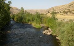
Tucannon River
Encyclopedia
Blue Mountains (Oregon)
The Blue Mountains are a mountain range in the western United States, located largely in northeastern Oregon and stretching into southeastern Washington...
to a confluence with the Snake River
Snake River
The Snake is a major river of the greater Pacific Northwest in the United States. At long, it is the largest tributary of the Columbia River, the largest North American river that empties into the Pacific Ocean...
4 miles (6 km) upstream from Lyons Ferry Park and the mouth of the Palouse River
Palouse River
The Palouse River is a tributary of the Snake River located in the U.S. states of Washington and Idaho. It flows for southwestwards, primarily through the Palouse region of southeastern Washington...
. The Tucannon itself drains 318 square miles (823.6 km²) and is 62.3 miles (100.3 km) long. Tributary Pataha Creek enters the Tucannon about 11 miles (18 km) above the Tucannon's confluence with the Snake River
Snake River
The Snake is a major river of the greater Pacific Northwest in the United States. At long, it is the largest tributary of the Columbia River, the largest North American river that empties into the Pacific Ocean...
, and drains a watershed of an additional 185 square miles (479.1 km²).
The Tucannon basin ranges in elevation from 540 feet (165 m) above sea level at the confluence of the Tucannon River and Snake River to 6400 feet (1,950.7 m) above sea level in the Wenaha–Tucannon Wilderness, which lies in the Umatilla National Forest
Umatilla National Forest
The Umatilla National Forest, in the Blue Mountains of northeast Oregon and southeast Washington, covers an area of 1.4 million acres . In descending order of land area the forest is located in parts of Umatilla, Grant, Columbia, Morrow, Wallowa, Union, Garfield, Asotin, Wheeler, and Walla Walla...
of the Blue Mountains.
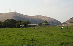
Water availability
The total water rights claims and state issued water claims exceed the mean daily flow in the river, and there are further applications pending to support agriculture. Since the aquifer is continuous with the surface water, continued extraction for irrigation will reduce surface flow.Fishing
Chinook salmon
The Chinook salmon, Oncorhynchus tshawytscha, is the largest species in the pacific salmon family. Other commonly used names for the species include King salmon, Quinnat salmon, Spring salmon and Tyee salmon...
as well as bull trout
Bull trout
The bull trout, Salvelinus confluentus, is a char of the family Salmonidae native to northwestern North America. Historically, S. confluentus has been known as the "Dolly Varden" , but was re-classified as a separate species in 1980. Bull trout are listed as a threatened species under the U.S....
and steelhead. The areas which are closed protect the main spawning grounds.
Steelhead and bull trout may be caught, following prescribed fishing restrictions. The accessible areas of the Tucannon River are popular fishing areas. The Tucannon winds through National Forest, State, and private lands, some of which are in stretches open to fishing. There are eight fishing ponds open to public fishing developed by the Washington Department of Fish and Wildlife and routinely stocked. Rainbow, Deer, Blue, Spring, Curl, Beaver, Watson and fly fishing-only Big Four Lake make up these wonderful trout opportunities. Fishing access can also be gained at the Tucannon Fish Hatchery where the river is bordered by State or National Forest land.
Camping
The Tucannon Campground is operated by the U.S. Forest Service in the Tucannon River Valley as one of 15 campgrounds in the Pomeroy Ranger District.Washington State Parks operates a group camp and homes at Camp Wooten, near a popular group camping recreation site on the upper Tucannon River.
Native peoples
The Nez Perce Trail followed part of the Touchet and Tucannon, extending east from Wallula and reaching the Touchet River below Waitsburg. From there it followed the southern bank of the Touchet River to present day Dayton. Here it crossed the river and followed Patit Creek northeast. Passing over.... pass to meet the Tucannon.
Lewis and Clark expedition
On October 12, 1805, after a difficult passage through rapids several miles above the mouth of the Tucannon, Lewis and Clark passed through a shorter one just east of the mouth of the present day Tucannon River. Lewis recorded ..."This is called Kimooenim creek". The expedition did not stop, but continued down the river in their dugouts.Lewis and Clark on their return trip to St. Louis on May 2, 1806, Lewis and Clark followed the Nez Perce Trail, crossing over from Patit Creek about two-and-a-half miles east of present-day Dayton to meet the Tucannon. Only 12 miles (19 km) beyond their campsite they reached the Tucannon River. "This creek rises in the southwest [Blue] mountains, and though only twelve yards wide discharges a considerable body of water into Lewis' river (the Snake River), a few miles above the narrows. Its bed is pebbled . . . in its narrow bottoms are found some cottonwood, willow and the underbrush which grows equally on the east branch of the Wollawollah [Touchet]." (add photo). Lewis and Clark camped on the Pataha Creek (a tributary to the Tucannon), which is recorded as the first locality for some distance where they were able to find ample firewood.
The British fur trade
The fur industry was important in the region. The Tucannon River provided a profitable area for beaver and otter trapping, which were abundant. F. A. Shaver's 1906 book, An Illustrated History of Southeastern Washington, that prior to 1834, the British Hudson's Bay Company (the British fur-trading company) was "undisputed occupants since 1829." A party was led by John Work, who served as an agent of Hudson's Bay Company. Starting from Fort Nez Perce in September 1831, Work and a 56-person party followed the Nez Perce Trail to the Upper Snake River country.American survey and settlement
In the late winter of 1834, Captain B. L. E. Bonneville crossed the Tucannon on the Nez Perce Trail, surveying the Northwest on behalf of the United States government.A number of wagon roads were built through the area in the 1860s (including a Walla Walla to Lewiston, Idaho, wagon road in 1862). Settlers slowly drifted into the Tucannon River area in the 1860s, but in the early 1870s settlement rapidly increased.
Cayuse War
Cayuse War
The Cayuse War was an armed conflict that took place in the Northwestern United States from 1847 to 1855 between the Cayuse people of the region and the United States Government and local Euro-American settlers...
Hall's Company fought an engagement with the Cayuse on the Tucannon River:
"Returning to Waiilatpu, the best mounted and equipped of the riflemen, and Hall's company among them, were selected for an expedition against the CayuseCayuseThe Cayuse are a Native American tribe in the state of Oregon in the United States. The Cayuse tribe shares a reservation in northeastern Oregon with the Umatilla and the Walla Walla tribes as part of the Confederated Tribes of the Umatilla Indian Reservation...
Indians, whose exact location was at this time unknown. The object was to bring the Indians to terms by some means, by fighting or otherwise, and recapture the stock stolen from the whites. The expedition started about the 10th of March, 1848, and after a search of ten days or so found the enemy encamped on Tucannon River, about 4 miles (6.4 km) above its confluence with the Columbia. The enemy adopted the ruse of hoisting a white flag, asked for and had a talk with the troops, anti pretended not to belong to the hostile party; but, upon the whites taking charge of the stock of the murdered pioneers, which were herding on the adjacent hills, the wily foe threw off the mask, and began an impetuous attack. The troops, greatly outnumbered, fought on the defensive, marching in retreat, formed in a hollow square, to resist the assaults made on all sides. The first night the captured stock was turned loose. The next morning the attack and retreat continued, and the Indians, as the Touchet River crossing was approached, took possession of it, attempting thereby to cutoff the retreat of the troops effectually. Here nothing but the most determined charge and fighting drove off the Indians and enabled the whites to cross that river and thus escape threatened extermination."
Spokane – Coeur d'Alene – Paloos War
During the Spokane – Coeur d'Alene – Paloos War on August 7, 1858, Captain Keyes with a detachment of dragoons was ordered to the Snake River to erect a Fort at a crossing point near the Palouse River. He selected the mouth of Tucannon River to establish Fort TaylorFort Taylor (Washington)
Fort Taylor, in Washington Territory was a temporary Army post established early in August 1858, by Captain E. D. Keyes with a detachment of dragoons, during the Spokane – Coeur d'Alene – Paloos War. The fort was located on the south bank of the Snake River at the mouth of the Tucannon River...
(a supply depot which honored Captain Taylor—killed that same year while he served with Steptoe against the Spokanes in April. On August 25 this point served as a crossing point for Colonel Wright, who led a force of 570 men across the Snake. It took several days to find a path to ascend from the Snake valley into the badlands above; this journey led them to the Battle of Four Lakes
Battle of Four Lakes
The Battle of Four Lakes was a battle during a US Army expedition against a confederation of Indian tribes in Washington and Idaho. Indian resistance to U.S. troops in the area had continued as part of the Yakima War. Commander of the Department of the Pacific, General Newman S. Clarke sent a...
on September 5.
Later history
Today