
.gif)
Kipling (TTC)
Encyclopedia
Toronto subway and RT
The Toronto subway and RT is a rapid transit system in Toronto, Ontario, Canada, consisting of both underground and elevated railway lines, operated by the Toronto Transit Commission . It was Canada's first completed subway system, with the first line being built under Yonge Street, which opened in...
in Toronto
Toronto
Toronto is the provincial capital of Ontario and the largest city in Canada. It is located in Southern Ontario on the northwestern shore of Lake Ontario. A relatively modern city, Toronto's history dates back to the late-18th century, when its land was first purchased by the British monarchy from...
, Ontario
Ontario
Ontario is a province of Canada, located in east-central Canada. It is Canada's most populous province and second largest in total area. It is home to the nation's most populous city, Toronto, and the nation's capital, Ottawa....
, Canada
Canada
Canada is a North American country consisting of ten provinces and three territories. Located in the northern part of the continent, it extends from the Atlantic Ocean in the east to the Pacific Ocean in the west, and northward into the Arctic Ocean...
. It is the westernmost station in the system. It is located on St. Albans Road at Aukland Road, near 5247 Dundas Street West
Dundas Street (Toronto)
Dundas Street, also known as Highway 5 west of Toronto, is a major arterial road connecting the centre of that city with its western suburbs and southwestern Ontario beyond...
at its more westerly intersection with Bloor Street
Bloor Street
Bloor Street is a major east–west residential and commercial thoroughfare in Toronto, in the Canadian province of Ontario. Bloor Street runs from the Prince Edward Viaduct westward into Mississauga, where it ends at Central Parkway. East of the viaduct, Danforth Avenue continues along the same...
West, and near Kipling Avenue
Kipling Avenue
Kipling Avenue, originally named Mimico Avenue, is a street in the Etobicoke district of Toronto, Ontario, Canada. It is a concession road, 6 concessions from Yonge Street, and is a major north–south arterial road that also extends beyond Toronto, into the Regional Municipality of York.The...
.
The station was designed around commuter travel, as it is the terminus of the line, and there is little density in the area. The station is also underneath power lines, and is near a hydro substation
Electrical substation
A substation is a part of an electrical generation, transmission, and distribution system. Substations transform voltage from high to low, or the reverse, or perform any of several other important functions...
. This provides space for parking (1751 spaces in four surrounding lots) and other amenities such as a ‘Kiss & Ride’ passenger pick up/drop off area. Space was provided on the station’s bus level for a connecting rapid transit
Rapid transit
A rapid transit, underground, subway, elevated railway, metro or metropolitan railway system is an electric passenger railway in an urban area with a high capacity and frequency, and grade separation from other traffic. Rapid transit systems are typically located either in underground tunnels or on...
line similar to the original concept for the Scarborough RT, but an empty track bed and platform at the south end of the bus level is all that was built. High density residential and commercial developments are replacing some of the previous land uses, namely light industrial/commercial, and the former site of Michael Power/St. Joseph High School
Michael Power/St. Joseph High School
Michael Power/St. Joseph High School is a Toronto Catholic District School Board secondary school in the Etobicoke district of the city of Toronto, Canada....
.
Kipling connects with GO Transit
GO Transit
GO Transit is an inter-regional public transit system in Southern Ontario, Canada. It primarily serves the Greater Toronto and Hamilton Area conurbation, with operations extending to several communities beyond the GTHA proper in the Greater Golden Horseshoe...
's Kipling station on the Milton line. Also, one of two bus lines that provide regular service to Toronto Pearson International Airport
Toronto Pearson International Airport
Toronto Pearson International Airport is an international airport serving Toronto, Ontario, Canada; its metropolitan area; and the Golden Horseshoe, an urban agglomeration that is home to 8.1 million people – approximately 25% of Canada's population...
originates from this station.
History
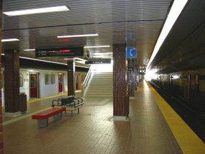
Kipling Station opened in what was then the Borough of Etobicoke, along with Kennedy stationKennedy (TTC)
Kennedy is the terminal subway station of the Bloor-Danforth and Scarborough RT lines of the Toronto subway and RT. It is located at 2455 Eglinton Avenue East, just east of Kennedy Road. The station opened in 1980 in what was then the Borough of Scarborough with the Bloor-Danforth platform, and the...
on the other end of the line, as part of east-west extensions to the Bloor-Danforth line. The station was opened to the public on November 22, 1980.
Subway infrastructure in the vicinity
A third tunnel structure exists on the north side of the station at ground level. This was to be the entrance into a subway yard that the TTC were considering building at the time when the station was being planned. There is a gravel bed trailing out eastward from the end of the tracks west of the station, likely meant for an extension of the line. There are no tracks laid on this section and it remains unused.For most of the way east to the next station (Islington
Islington (TTC)
Islington is a station on the Bloor–Danforth line of the subway system in Toronto, Canada. It is located at 3286 Bloor Street West at Islington Avenue. A central platform serves trains running in both directions....
) the line continues on the surface, alongside the railway right-of-way, paralleling Dundas Street at a distance. After crossing over Bloor Street to the north side, it turns somewhat to the right to take up the normal alignment parallel to Bloor. At this point the line goes underground.
Surface connections
- Route 30: Lambton
- 30 to High Park StationHigh Park (TTC)High Park is a station on the Bloor–Danforth line of the subway system in Toronto, Ontario, Canada. It is located at 1874 Bloor Street West at Quebec Avenue, near High Park Avenue. It was opened in 1968.-Station description:...
via Dundas Street - 30B to Colborne Lodge via High Park Station
- Route 44 Kipling South to Lake Shore Boulevard and Humber CollegeHumber CollegeHumber College Institute of Technology & Advanced Learning is a polytechnic college in Toronto, Ontario, Canada. Humber offers more than 150 programs including: bachelor’s degree, diploma, certificate, post-graduate certificate and apprenticeship programs, across 40 fields of study. Humber serves...
-Lakeshore Campus - Route 45: Kipling
- Route 44 Kipling South to Lake Shore Boulevard and Humber College
- 45 to Steeles AvenueSteeles AvenueSteeles Avenue is an east-west street that forms the northern city limit of Toronto and the southern limit of York Region, Ontario, Canada. It stretches across the western Greater Toronto Area from Milborough Townline in Halton Region east to the Scarborough-Pickering limit. It runs for within...
past Etobicoke North GO Station - 45A to Carlingview Drive along Belfield Road
- 45E express service to Steeles Avenue
- Route 46: Martin Grove to Steeles AvenueSteeles AvenueSteeles Avenue is an east-west street that forms the northern city limit of Toronto and the southern limit of York Region, Ontario, Canada. It stretches across the western Greater Toronto Area from Milborough Townline in Halton Region east to the Scarborough-Pickering limit. It runs for within...
- Route 49: Bloor West to Markland WoodMarkland WoodMarkland Wood is a residential neighbourhood located in Etobicoke, in the City of Toronto, Ontario, Canada. It is bounded by Etobicoke Creek to the west, Elmcrest Creek to the east and surrounded by the Markland Wood Country Club...
west of Highway 427 - Route 111: East Mall to Eglinton AvenueEglinton AvenueEglinton Avenue, originally known as the Richview Sideroad within Etobicoke, is an east-west arterial thoroughfare in Toronto and Mississauga, in the Canadian province of Ontario. Within Toronto, Eglinton Avenue is the only road which crosses through all six former boroughs...
(Willowridge & Richgrove) - Route 112: West Mall
- Route 46: Martin Grove to Steeles Avenue
- 112A to Renforth Loop
- 112C to Disco Road
- 112D to Eglinton and Skymark
- 112E express service to Renforth and Eringate Drive (Michael Power/St. Joseph High SchoolMichael Power/St. Joseph High SchoolMichael Power/St. Joseph High School is a Toronto Catholic District School Board secondary school in the Etobicoke district of the city of Toronto, Canada....
)
- Route 123: Shorncliffe
- 123 to Sherway Gardens Shopping Area, at The QueenswayThe QueenswayThe Queensway/Queensway Avenue is a major street in the municipalities of Toronto and Mississauga, Ontario, Canada. It is the western extension of Queen Street, after it merges with King Street near Roncesvalles Avenue in Toronto...
and Highway 427 - 123A to Sherway via North Queen
- 123C to Long Branch via North Queen and Sherway
- Route 191: Highway 27Ontario Highway 27Highway 27, formerly known as King's Highway 27, was a provincially maintained highway in southern Ontario that is now cared for by the city of Toronto, York Region and Simcoe County. It is considered an undivided expressway in Toronto's municipal expressway network...
Rocket to Steeles via Humber College North Campus - Route 192: Airport Rocket Express service to Toronto Pearson International Airport (Terminal 3)Toronto Pearson International AirportToronto Pearson International Airport is an international airport serving Toronto, Ontario, Canada; its metropolitan area; and the Golden Horseshoe, an urban agglomeration that is home to 8.1 million people – approximately 25% of Canada's population...
- Route 191: Highway 27
- IKEAIKEAIKEA is a privately held, international home products company that designs and sells ready-to-assemble furniture such as beds and desks, appliances and home accessories. The company is the world's largest furniture retailer...
Etobicoke customer courtesy shuttle (not a TTC route)
Modernization
Construction on a new 14-bay inter-regional bus terminal is planned and was originally scheduled to be completed in 2011. This would see GO Transit buses use the facility, and Mississauga TransitMississauga Transit
MiWay , is a public transport agency serving Mississauga, Ontario, Canada. The city's Transportation and Works department is in charge of its operation....
buses terminate at Kipling station instead of Islington as they currently do. The current parking facilities will be reconfigured to allow for the construction of the terminal. The modernization project would also include landscaping and revitalization of interior and exterior station finishes and lighting