
Kington, Herefordshire
Encyclopedia
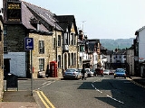
Kington is a market town
and civil parish in Herefordshire
, England
. According to the 2001 census
it had a population of 2,597.
, has been English
for over a thousand years. The town is in the shadow of Hergest Ridge
, and on the River Arrow, where it is crossed by the A44 road
. It is 21 miles (33.8 km) north-west of Hereford
. Nearby towns include Presteigne
, Knighton
and Leominster
. There are panoramic views all round the town of the open countryside and surrounding hills.
for "King's Town", similar to other nearby towns such as Presteigne meaning "Priest's Town" and Knighton being "Knight's Town".
Kington is to the west of Offa's Dyke so presumably this land was Welsh
in the 8th century AD. The land was held by Anglo-Saxons
in 1066, but devastated. After the Norman Conquest Kington then passed to the Crown on the downfall of Roger de Breteuil, 2nd Earl of Hereford
in 1075. Soon after 1086 and before 1108 the King gave Kington to Henry Port, who founded a new Marcher barony in this part of the early Welsh Marches
. Kington seems to have been a quiet barony and was associated with the office of sheriff
of Hereford. In 1072, Adam Port, probably the great-grandson of Henry Port, rebelled and fled the country. He returned in 1074 with a Scottish
army, only to flee from the resulting Battle of Alnwick
to the great mirth of the Norman court. With this his barony of Kington was taken by the Crown and became an appurtenance of the office of Sheriff of Hereford, finally being granted to William de Braose, 4th Lord of Bramber
in 1203 for £100. The castle then saw action in the Braose Wars against King John of England
and was probably destroyed by royal forces in August 1216. Within a few years a new fortress was commenced at nearby Huntington Castle
and Kington Castle
was abandoned. All that remains of Kington Castle today is a great outcrop of rock topped by a few fragmentary earthworks. The old town clustered around the castle
and Norman church on top of a defensive hill above the River Arrow.
‘Chingtune' was recorded in the Domesday Book in 1086, the name meaning Kings Town or Manor, high on the hill above the town where St. Mary's Church now stands. The new Kington, called Kyneton in the Fields, was laid out between 1175 and 1230 on land bordering the River Arrow and possibly designated as part of the Saxon open field system.
Situated on the direct route the drovers took from Hergest Ridge and with eight annual fairs, Kington grew in importance as a market town and there is still a thriving livestock market on Thursdays. The town retains the medieval grid pattern of streets and back lanes, which are a delight to explore.
In the chapel of St. Mary's Church, there is the alabaster tomb of Sir Thomas Vaughan of nearby Hergest Court, slain at the Battle of Banbury 1469, and his wife, Ellen the Terrible. The Black Dog of Hergest haunts the area around Hergest Ridge and his sighting presages death. It is also rumoured to have been the prototype for the Hound of the Baskervilles as Conan Doyle is known to have stayed at nearby Hergest Hall shortly before he wrote the novel.
Source: Extract from Littlebury's Directory and Gazetteer of Herefordshire, 1876-7 and National Census
, with limited seasonal temperature ranges, and generally moderate rainfall throughout the year. The nearest met office weather station is Lyonshall, around 2.5 miles to the east.
The absolute maximum temperature recorded is 33.5c(92.3f) during august 1990. In an average year however, the warmest day should record 27.8c(82.0f), with a total of 7.7 days reporting a value of 25.1c(77.2f) or above.
The absolute minimum temperature is -16.5c(2.3f), reported in December 1981. Typically 44.1 nights should record an air frost.
Rainfall averages around 845mm a year, with over 1mm falling on 136 days. All averages refer to the period 1971-00.
-trading market town
on an important drovers' road, and still thrives today. It is the reason why so many waymarked long-distance footpaths pass through Kington today, including: the Mortimer Trail
, the Herefordshire Trail
and Offa's Dyke Path
. The Black and White Village Trail follows the half-timbered cottages and houses in local Herefordshire villages.
In the mid 1800s, an assessment was thus: "The trade of the town is chiefly with the agriculturists of the adjoining county of Radnor. There are two banking establishments, viz., the head offices of the Kington and Radnorshire bank (Messrs. Davies, Banks, & Davies), established in 1808, and a branch of the Midland Banking Company, Limited. There is an extensive iron foundry, nail, and agricultural implement manufactory carried on by Messrs. James. Meredith & Co., and the building and tanning trades are well represented. There are also some extensive corn mills and malt-houses. About four miles west of the town are the Old Radnor lime rocks, which are celebrated for their superior quality for building and for agricultural purposes. The market day is Tuesday, considerable business being transacted on that day in eggs, butter, poultry, &c., and is the mart to which the Welsh send their produce, to meet dealers who frequent this town from all quarters." Source: Extract from Littlebury's Directory and Gazetteer of Herefordshire, 1876-7.
During the Second World War, the large Kington Camp was constructed close to the town by the War Office. It was first used by the British as a re-grouping point after Dunkirk, housing returned soldiers in often poor conditions. In 1943-4, Wimpeys built two US General Hospitals to cater for predicted wounded from the European campaigns. Each employed 500 US military and administrative personnel and 50 local people. There were administrative buildings, labs, operating theatres and dental clinics as well as personnel quarters, chapels, rehabilitation wards, cinemas, mess halls, warehouses, and laboratories. Between 1944-1945 there were 13,000 patients. After the war buildings were used by the Polish Resettlement Corps (many of the Poles who had fought alongside Western allies did not wish to return to a newly communist dominated Poland). Many of the buildings at the Camp remain standing, although two thirds have disappeared since the Second World War. Some are used by local businesses.
The Kington economy has suffered along with the fortunes of the farming industry. Its rural location and lack of good transport connections means local unemployment has been high for many decades, with low pay rates and many part-time occupations in small businesses including farming and the retail and service sectors. There is a small tourist industry, concentrated in the summer months. County unemployment figures are here and show a rise from 2008 to the present. A notable exception, that put Kington on the world map, was the Kington Connected Community Company (KC3). KC3 was begun in 1993, when BT, Apple, the Department of Trade and Industry and the Rural Development Commission chose Kington to host a pilot study into the effect that IT and sophisticated telecommunications might have on small communities. 15 ISDN lines were installed for digital data transmission and KC3 became a remote office and payroll service for companies including ICI and banks, with remote "teleworking". There was also significant support to local businesses and schools. In 2006 Kc3 had a buyout. In 2009 there was a further management buyout by V8 media which signalled the end of KC3. V8 Media moved operations to Hereford
.
One of the largest employers in the town is Kington Building Supplies which is owned by Allan & Eileen Edwards. They have been established for over 25 years and are the largest independent builders merchant in Herefordshire with a site of over 3 acres.
to fly the Red Ensign
on its foundress day. Lady Hawkins School was also the school where singer Ellie Goulding attended before moving to Hereford Sixth Form College
The Leominster and Kington Railway
received royal assent in July 1854, and the 13 miles and 25 chain length opened to Kington in August 1857. Leased to the Great Western Railway
from 1862, it was later amalgamated with it. Traffic rose during World War II
, with the US Army hospital camp at Hergest. Decline set in after the war, and it closed to passengers on 5 February 1955. Freight traffic ceased in 1964, after which the track was taken up and the line abandoned.
Today the nearest station is Knighton
on the Heart of Wales Line
.
Shobdon Aerodrome
is located close to the town.
on Bradnor Hill is the highest golf club in England
. It provides wooden shelters on the course for golfers caught out by the weather.
Kington has also been the host town for the Marin Rough (cycle) Ride since 2003.
Market town
Market town or market right is a legal term, originating in the medieval period, for a European settlement that has the right to host markets, distinguishing it from a village and city...
and civil parish in Herefordshire
Herefordshire
Herefordshire is a historic and ceremonial county in the West Midlands region of England. For Eurostat purposes it is a NUTS 3 region and is one of three counties that comprise the "Herefordshire, Worcestershire and Gloucestershire" NUTS 2 region. It also forms a unitary district known as the...
, England
England
England is a country that is part of the United Kingdom. It shares land borders with Scotland to the north and Wales to the west; the Irish Sea is to the north west, the Celtic Sea to the south west, with the North Sea to the east and the English Channel to the south separating it from continental...
. According to the 2001 census
Census
A census is the procedure of systematically acquiring and recording information about the members of a given population. It is a regularly occurring and official count of a particular population. The term is used mostly in connection with national population and housing censuses; other common...
it had a population of 2,597.
Location
Kington is near the Wales-England border and, despite being on the western side of Offa's DykeOffa's Dyke
Offa's Dyke is a massive linear earthwork, roughly followed by some of the current border between England and Wales. In places, it is up to wide and high. In the 8th century it formed some kind of delineation between the Anglian kingdom of Mercia and the Welsh kingdom of Powys...
, has been English
England
England is a country that is part of the United Kingdom. It shares land borders with Scotland to the north and Wales to the west; the Irish Sea is to the north west, the Celtic Sea to the south west, with the North Sea to the east and the English Channel to the south separating it from continental...
for over a thousand years. The town is in the shadow of Hergest Ridge
Hergest Ridge
Hergest Ridge is a large elongated hill which traverses the border between England and Wales between the town of Kington in Herefordshire and the village of Gladestry in Powys. Its highest point, which is in England, is 1397 feet high.- On Offa's Dyke Path :...
, and on the River Arrow, where it is crossed by the A44 road
A44 road
The A44 is a major road in the United Kingdom that runs from Oxford in southern England to Aberystwyth in west Wales.-History:The original route of the A44 was Chipping Norton to Aberystwyth. No changes were made to the route of the A44 in the early years...
. It is 21 miles (33.8 km) north-west of Hereford
Hereford
Hereford is a cathedral city, civil parish and county town of Herefordshire, England. It lies on the River Wye, approximately east of the border with Wales, southwest of Worcester, and northwest of Gloucester...
. Nearby towns include Presteigne
Presteigne
Presteigne is a town and community in Powys, Wales. It was the county town of the historic county of Radnorshire, and is in the Diocese of Hereford...
, Knighton
Knighton
Knighton may mean:* Knighton, Powys a market town on the English/Welsh border**Knighton railway station serving the above town**Knighton Town F.C., its football club* Knighton, Leicestershire, a suburb of Leicester, England* In Staffordshire:...
and Leominster
Leominster
Leominster is a market town in Herefordshire, England, located approximately north of the city of Hereford and south of Ludlow, at...
. There are panoramic views all round the town of the open countryside and surrounding hills.
History
Kington may have derived from King's-ton, being Anglo-SaxonAnglo-Saxon
Anglo-Saxon may refer to:* Anglo-Saxons, a group that invaded Britain** Old English, their language** Anglo-Saxon England, their history, one of various ships* White Anglo-Saxon Protestant, an ethnicity* Anglo-Saxon economy, modern macroeconomic term...
for "King's Town", similar to other nearby towns such as Presteigne meaning "Priest's Town" and Knighton being "Knight's Town".
Kington is to the west of Offa's Dyke so presumably this land was Welsh
Wales
Wales is a country that is part of the United Kingdom and the island of Great Britain, bordered by England to its east and the Atlantic Ocean and Irish Sea to its west. It has a population of three million, and a total area of 20,779 km²...
in the 8th century AD. The land was held by Anglo-Saxons
Anglo-Saxons
Anglo-Saxon is a term used by historians to designate the Germanic tribes who invaded and settled the south and east of Great Britain beginning in the early 5th century AD, and the period from their creation of the English nation to the Norman conquest. The Anglo-Saxon Era denotes the period of...
in 1066, but devastated. After the Norman Conquest Kington then passed to the Crown on the downfall of Roger de Breteuil, 2nd Earl of Hereford
Roger de Breteuil, 2nd Earl of Hereford
Roger de Breteuil, 2nd Earl of Hereford , succeeded to the earldom of Hereford and the English estate of William Fitz-Osbern in 1071.- Disobeying King William :...
in 1075. Soon after 1086 and before 1108 the King gave Kington to Henry Port, who founded a new Marcher barony in this part of the early Welsh Marches
Welsh Marches
The Welsh Marches is a term which, in modern usage, denotes an imprecisely defined area along and around the border between England and Wales in the United Kingdom. The precise meaning of the term has varied at different periods...
. Kington seems to have been a quiet barony and was associated with the office of sheriff
Sheriff
A sheriff is in principle a legal official with responsibility for a county. In practice, the specific combination of legal, political, and ceremonial duties of a sheriff varies greatly from country to country....
of Hereford. In 1072, Adam Port, probably the great-grandson of Henry Port, rebelled and fled the country. He returned in 1074 with a Scottish
Scotland
Scotland is a country that is part of the United Kingdom. Occupying the northern third of the island of Great Britain, it shares a border with England to the south and is bounded by the North Sea to the east, the Atlantic Ocean to the north and west, and the North Channel and Irish Sea to the...
army, only to flee from the resulting Battle of Alnwick
Battle of Alnwick (1093)
The Battle of Alnwick is one of two battles fought near the town of Alnwick, in Northumberland, England. In the battle, which occurred on 13 November 1093, Malcolm III of Scotland, also known as Malcolm Canmore, was killed together with his son Edward, by an army of knights led by Robert de...
to the great mirth of the Norman court. With this his barony of Kington was taken by the Crown and became an appurtenance of the office of Sheriff of Hereford, finally being granted to William de Braose, 4th Lord of Bramber
William de Braose, 4th Lord of Bramber
William de Braose, , 4th Lord of Bramber , court favourite of King John of England, at the peak of his power, was also Lord of Gower, Abergavenny, Brecknock, Builth, Radnor, Kington, Limerick, Glamorgan, Skenfrith, Briouze in Normandy, Grosmont, and White Castle.-Lineage:William was the most...
in 1203 for £100. The castle then saw action in the Braose Wars against King John of England
John of England
John , also known as John Lackland , was King of England from 6 April 1199 until his death...
and was probably destroyed by royal forces in August 1216. Within a few years a new fortress was commenced at nearby Huntington Castle
Huntington Castle
Huntington Castle was situated in the village of Huntingdon in Herefordshire, England, 2½ miles south-west of Kington .- Natural Site :The castle is sited on a commanding position on the modern day England Wales border in what was the Welsh Marches in Norman and medieval times...
and Kington Castle
Kington Castle
Kington Castle stood in the medieval market town of Kington in Herefordshire, England .- Welsh Marches Border Castle :The castle was sited to the north west of the present town of Kington above the Back Brook. Around the end of the 11th century William Rufus granted the estates in and around...
was abandoned. All that remains of Kington Castle today is a great outcrop of rock topped by a few fragmentary earthworks. The old town clustered around the castle
Castle
A castle is a type of fortified structure built in Europe and the Middle East during the Middle Ages by European nobility. Scholars debate the scope of the word castle, but usually consider it to be the private fortified residence of a lord or noble...
and Norman church on top of a defensive hill above the River Arrow.
‘Chingtune' was recorded in the Domesday Book in 1086, the name meaning Kings Town or Manor, high on the hill above the town where St. Mary's Church now stands. The new Kington, called Kyneton in the Fields, was laid out between 1175 and 1230 on land bordering the River Arrow and possibly designated as part of the Saxon open field system.
Situated on the direct route the drovers took from Hergest Ridge and with eight annual fairs, Kington grew in importance as a market town and there is still a thriving livestock market on Thursdays. The town retains the medieval grid pattern of streets and back lanes, which are a delight to explore.
In the chapel of St. Mary's Church, there is the alabaster tomb of Sir Thomas Vaughan of nearby Hergest Court, slain at the Battle of Banbury 1469, and his wife, Ellen the Terrible. The Black Dog of Hergest haunts the area around Hergest Ridge and his sighting presages death. It is also rumoured to have been the prototype for the Hound of the Baskervilles as Conan Doyle is known to have stayed at nearby Hergest Hall shortly before he wrote the novel.
Population
| Population | Year |
|---|---|
| 2,062 | 1801 |
| 2,312 | 1811 |
| 2,813 | 1821 |
| 3,111 | 1831 |
| 3,139 | 1841 |
| 2,871 | 1851 |
| 3,076 | 1861 |
| 3,111 | 1871 |
| .. | .. |
| .. | .. |
| 2,597 | 2001 |
| awaited | 2011 |
Source: Extract from Littlebury's Directory and Gazetteer of Herefordshire, 1876-7 and National Census
Climate
As with the rest of the UK, Kington benefits from a maritime climateOceanic climate
An oceanic climate, also called marine west coast climate, maritime climate, Cascadian climate and British climate for Köppen climate classification Cfb and subtropical highland for Köppen Cfb or Cwb, is a type of climate typically found along the west coasts at the middle latitudes of some of the...
, with limited seasonal temperature ranges, and generally moderate rainfall throughout the year. The nearest met office weather station is Lyonshall, around 2.5 miles to the east.
The absolute maximum temperature recorded is 33.5c(92.3f) during august 1990. In an average year however, the warmest day should record 27.8c(82.0f), with a total of 7.7 days reporting a value of 25.1c(77.2f) or above.
The absolute minimum temperature is -16.5c(2.3f), reported in December 1981. Typically 44.1 nights should record an air frost.
Rainfall averages around 845mm a year, with over 1mm falling on 136 days. All averages refer to the period 1971-00.
Economy
In the 13th century the new medieval town was formed at the foot of the hill and became primarily a woolWool
Wool is the textile fiber obtained from sheep and certain other animals, including cashmere from goats, mohair from goats, qiviut from muskoxen, vicuña, alpaca, camel from animals in the camel family, and angora from rabbits....
-trading market town
Market town
Market town or market right is a legal term, originating in the medieval period, for a European settlement that has the right to host markets, distinguishing it from a village and city...
on an important drovers' road, and still thrives today. It is the reason why so many waymarked long-distance footpaths pass through Kington today, including: the Mortimer Trail
Mortimer Trail
Mortimer Trail is a waymarked long distance footpath and recreational walk in the counties of Shropshire and Herefordshire in England.- The route :...
, the Herefordshire Trail
Herefordshire Trail
The Herefordshire Trail is a long distance footpath forming a circular walk in the English county of Herefordshire.- Route & Distance :The Herefordshire Trail runs for 154 miles and forms a circular tour of the county of Herefordshire....
and Offa's Dyke Path
Offa's Dyke Path
Offa's Dyke Path is a long distance footpath along the Welsh-English border. Opened in 1971, it is one of Britain's premier National Trails and draws walkers from throughout the world...
. The Black and White Village Trail follows the half-timbered cottages and houses in local Herefordshire villages.
In the mid 1800s, an assessment was thus: "The trade of the town is chiefly with the agriculturists of the adjoining county of Radnor. There are two banking establishments, viz., the head offices of the Kington and Radnorshire bank (Messrs. Davies, Banks, & Davies), established in 1808, and a branch of the Midland Banking Company, Limited. There is an extensive iron foundry, nail, and agricultural implement manufactory carried on by Messrs. James. Meredith & Co., and the building and tanning trades are well represented. There are also some extensive corn mills and malt-houses. About four miles west of the town are the Old Radnor lime rocks, which are celebrated for their superior quality for building and for agricultural purposes. The market day is Tuesday, considerable business being transacted on that day in eggs, butter, poultry, &c., and is the mart to which the Welsh send their produce, to meet dealers who frequent this town from all quarters." Source: Extract from Littlebury's Directory and Gazetteer of Herefordshire, 1876-7.
During the Second World War, the large Kington Camp was constructed close to the town by the War Office. It was first used by the British as a re-grouping point after Dunkirk, housing returned soldiers in often poor conditions. In 1943-4, Wimpeys built two US General Hospitals to cater for predicted wounded from the European campaigns. Each employed 500 US military and administrative personnel and 50 local people. There were administrative buildings, labs, operating theatres and dental clinics as well as personnel quarters, chapels, rehabilitation wards, cinemas, mess halls, warehouses, and laboratories. Between 1944-1945 there were 13,000 patients. After the war buildings were used by the Polish Resettlement Corps (many of the Poles who had fought alongside Western allies did not wish to return to a newly communist dominated Poland). Many of the buildings at the Camp remain standing, although two thirds have disappeared since the Second World War. Some are used by local businesses.
The Kington economy has suffered along with the fortunes of the farming industry. Its rural location and lack of good transport connections means local unemployment has been high for many decades, with low pay rates and many part-time occupations in small businesses including farming and the retail and service sectors. There is a small tourist industry, concentrated in the summer months. County unemployment figures are here and show a rise from 2008 to the present. A notable exception, that put Kington on the world map, was the Kington Connected Community Company (KC3). KC3 was begun in 1993, when BT, Apple, the Department of Trade and Industry and the Rural Development Commission chose Kington to host a pilot study into the effect that IT and sophisticated telecommunications might have on small communities. 15 ISDN lines were installed for digital data transmission and KC3 became a remote office and payroll service for companies including ICI and banks, with remote "teleworking". There was also significant support to local businesses and schools. In 2006 Kc3 had a buyout. In 2009 there was a further management buyout by V8 media which signalled the end of KC3. V8 Media moved operations to Hereford
Hereford
Hereford is a cathedral city, civil parish and county town of Herefordshire, England. It lies on the River Wye, approximately east of the border with Wales, southwest of Worcester, and northwest of Gloucester...
.
One of the largest employers in the town is Kington Building Supplies which is owned by Allan & Eileen Edwards. They have been established for over 25 years and are the largest independent builders merchant in Herefordshire with a site of over 3 acres.
Education
Sir Francis Drake's cousin Sir John Hawkins married, and in her will, Lady Hawkins left £800 to the town to establish a school. The school is unique in having special permission from the Royal NavyRoyal Navy
The Royal Navy is the naval warfare service branch of the British Armed Forces. Founded in the 16th century, it is the oldest service branch and is known as the Senior Service...
to fly the Red Ensign
Red Ensign
The Red Ensign or "Red Duster" is a flag that originated in the early 17th century as a British ensign flown by the Royal Navy and later specifically by British merchantmen. The precise date of its first appearance is not known, but surviving receipts indicate that the Navy was paying to have such...
on its foundress day. Lady Hawkins School was also the school where singer Ellie Goulding attended before moving to Hereford Sixth Form College
Transport
Sargeants Brothers was founded in the 1920s, providing bus services to Hereford and Mid Wales. No longer run by the brothers but their sons, the Sargeant family also own and run the Fleece Meadow Caravan and Camping site at the rear of Sargeants bus depot.The Leominster and Kington Railway
Leominster and Kington Railway
Leominster and Kington Railway was one of four branches which served the Welsh Marches border town of Kington, Herefordshire.Opened in August 1857, its peak was during World War II, when it served two US Army hospitals...
received royal assent in July 1854, and the 13 miles and 25 chain length opened to Kington in August 1857. Leased to the Great Western Railway
Great Western Railway
The Great Western Railway was a British railway company that linked London with the south-west and west of England and most of Wales. It was founded in 1833, received its enabling Act of Parliament in 1835 and ran its first trains in 1838...
from 1862, it was later amalgamated with it. Traffic rose during World War II
World War II
World War II, or the Second World War , was a global conflict lasting from 1939 to 1945, involving most of the world's nations—including all of the great powers—eventually forming two opposing military alliances: the Allies and the Axis...
, with the US Army hospital camp at Hergest. Decline set in after the war, and it closed to passengers on 5 February 1955. Freight traffic ceased in 1964, after which the track was taken up and the line abandoned.
Today the nearest station is Knighton
Knighton railway station
Knighton railway station serves the market town of Knighton in Powys, Wales, although the station itself is located in Shropshire, England . It lies south west of Shrewsbury ....
on the Heart of Wales Line
Heart of Wales Line
The Heart of Wales Line is a railway line running from Craven Arms in Shropshire to Llanelli in South Wales. It runs, as the name suggests, through some of the heartlands of Wales. It serves a number of rural centres en route, including several once fashionable spa towns, including Llandrindod Wells...
.
Shobdon Aerodrome
Shobdon Aerodrome
Shobdon Aerodrome is an airport west of Leominster, Herefordshire, England.-RAF Shobdon:Shobdon started as a British Army camp. Out of range of long range German Luftwaffe bombers, it acted as a reception point for casualties received from Southampton distributed to existing local hospitals...
is located close to the town.
Sport
Kington Golf Club at 1,100 ft above sea levelSea level
Mean sea level is a measure of the average height of the ocean's surface ; used as a standard in reckoning land elevation...
on Bradnor Hill is the highest golf club in England
England
England is a country that is part of the United Kingdom. It shares land borders with Scotland to the north and Wales to the west; the Irish Sea is to the north west, the Celtic Sea to the south west, with the North Sea to the east and the English Channel to the south separating it from continental...
. It provides wooden shelters on the course for golfers caught out by the weather.
Kington has also been the host town for the Marin Rough (cycle) Ride since 2003.
Visitor attractions
- Hergest Croft Gardens
- Kington Festival
- Kington Museum, summer months.
Notable people
- Ellie GouldingEllie GouldingElena Jane "Ellie" Goulding is an English singer-songwriter. In 2010 she became only the second artist to both top the BBC's annual Sound of... poll, and win the Critics' Choice Award at the BRIT Awards in the same year, following Adele's win of both in 2008...
, pop singer, went to Lady Hawkins' School and played the part of the 'Scarecrow' in their 2003 show. - Stephen KembleStephen KembleGeorge Stephen Kemble was a successful theatre manager, British actor, writer, and a member of the famous Kemble family....
, of the acting family, the Kemble familyKemble familyKemble is the name of a family of English actors, all distinguished actors and actresses who reigned over the British stage for decades. The most famous were Sarah Siddons and her brother John Philip Kemble , the two eldest of the twelve children of Roger Kemble , a strolling player and manager of...
, born here in 1758 - Mike OldfieldMike OldfieldMichael Gordon Oldfield is an English multi-instrumentalist musician and composer, working a style that blends progressive rock, folk, ethnic or world music, classical music, electronic music, New Age, and more recently, dance. His music is often elaborate and complex in nature...
lived at The Beacon, on Bradnor Hill near Kington, in the mid-1970s, the nearby Hergest RidgeHergest RidgeHergest Ridge is a large elongated hill which traverses the border between England and Wales between the town of Kington in Herefordshire and the village of Gladestry in Powys. Its highest point, which is in England, is 1397 feet high.- On Offa's Dyke Path :...
inspiring the album of the same nameHergest Ridge (album)Hergest Ridge is the second record album by Mike Oldfield, released in 1974 on Virgin Records.Oldfield was not comfortable with the public attention that had come from the success of Tubular Bells, and retreated to the English countryside to work on the follow-up...
. Oldfield turned parts of the house into a recording studio, where he recorded his 1975 album OmmadawnOmmadawnOmmadawn is the third record album by Mike Oldfield, released in 1975 on Virgin Records. The cover photograph was by David Bailey. It peaked at #4 on the UK Albums Chart. The album was reissued in June 2010 with additional content.- Album history :...
. - Australian artist Sidney NolanSidney NolanSir Sidney Robert Nolan OM, AC was one of Australia's best-known painters and printmakers.-Early life:Nolan was born in Carlton, a suburb of Melbourne, on 22 April 1917. He was the eldest of four children. His family later moved to St Kilda. Nolan attended the Brighton Road State School and...
lived a few miles north of Kington, right next to the Welsh border, at | The Rodd, from 1983 until his death. A | Trust in his name supports the arts in Herefordshire and further afield, and now owns the property and farmland.
External links
- Kington Tourist Information Office
- Kington Castle
- Anglo-Norman castles
- Marches Access Point
- Kington and Surround Parishes
- Kington Blackboard community noticeboard started by KC3.