

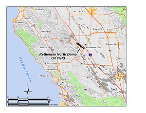
Kettleman North Dome Oil Field
Encyclopedia
Kings County, California
Kings County is a county located in the Central Valley of the U.S. state of California. It is located in a rich agricultural region. Kings County is also home to NAS Lemoore, which is the U.S. Navy's newest and largest master jet air station. The county seat is Hanford...
and Fresno Counties
Fresno County, California
Fresno County is a county located in the Central Valley of the U.S. state of California, south of Stockton and north of Bakersfield. As of the 2010 census, it is the tenth most populous county in California with a population of 930,450, and the sixth largest in size with an area of . The county...
, California. Discovered in 1928, it is fifteenth largest field in the state by total ultimate oil recovery, and of the top twenty oil fields it is the closest to exhaustion, with less than one-half of one percent of its total original oil remaining in place.
Setting
The Kettleman North Dome occupies the northernmost portion of the Kettleman HillsKettleman Hills
The Kettleman Hills is a low mountain range of the interior California Coast Ranges, in western Kings County, California. It is a northwest-southeast trending line of hills about 30 miles long which parallels the San Andreas Fault to the west....
, a northwest-southeast trending line of hills about 30 miles (48.3 km) long which parallels the San Andreas Fault
San Andreas Fault
The San Andreas Fault is a continental strike-slip fault that runs a length of roughly through California in the United States. The fault's motion is right-lateral strike-slip...
to the west. The range consists of two elongate "domes", the North Dome and Middle Dome; a portion of the Middle Dome is sometimes called the "South Dome," although the North and Middle Dome are the most topographically distinct. Both the North and Middle Domes overlie oil fields.
The Kettleman Hills is named, and misspelled, after Dave Kettelman, a pioneer sheep and cattle rancher who grazed his animals there in the 1860s. The hills, which rise to an elevation of approximately 1200 feet (365.8 m), divide the San Joaquin Valley
San Joaquin Valley
The San Joaquin Valley is the area of the Central Valley of California that lies south of the Sacramento – San Joaquin River Delta in Stockton...
on the east from the much smaller Kettleman Plain to the west. They are discontinuous, as indicated by their name ("hills" rather than "ridge"). The predominant vegetation in the hills themselves is grassland, with surrounding areas containing grassland, low scrub, orchards, and agricultural fields. The climate is arid, with 6 to 12 inches (304.8 mm) of precipitation per year on the average, all falling as rain. Summers are hot, with daily highs regularly exceeding 100 °F (37.8 °C) in the summer months, and winters are cool with occasional freezes.
Interstate 5 parallels the range of hills to the northeast, and SR 33 to the southwest. State Route 41, which runs from Paso Robles to Kettleman City to Fresno, crosses the hills at the southern extremity of the North Dome, and SR 269, which connects the town of Avenal to Interstate 5, crosses the hills in the middle of the North Dome.
North Dome itself is one of the longest of the California oil fields; only Midway-Sunset is longer. Its long axis, northwest to southeast, is approximately 14 miles (22.5 km), and it is almost three miles (5 km) across at its widest point.
Geology
The oil field is one of a long line of similar long, narrow, anticlinalAnticline
In structural geology, an anticline is a fold that is convex up and has its oldest beds at its core. The term is not to be confused with antiform, which is a purely descriptive term for any fold that is convex up. Therefore if age relationships In structural geology, an anticline is a fold that is...
fields paralleling the San Andreas Fault, where tectonic forces squeezed the rock formations into anticlinal structures, trapping large quantities of petroleum. To the northwest is the large Coalinga Oil Field
Coalinga Oil Field
The Coalinga Oil Field is a large oil field in western Fresno County, California, in the United States. It surrounds the town of Coalinga, about half-way between Los Angeles and San Francisco, to the west of Interstate 5, at the foot of the Diablo Range...
; to the southeast are the Lost Hills Oil Field
Lost Hills Oil Field
The Lost Hills Oil Field is a large oil field in the Lost Hills Range, north of the town of Lost Hills in western Kern County, California, in the United States.-Production:...
, Cymric
Cymric Oil Field
The Cymric Oil Field is a large oil field in Kern County, California in the United States. While only the 14th-largest oil field in California in total size, in terms of total remaining reserves it ranks fifth, with the equivalent of over still in the ground...
, McKittrick
McKittrick Oil Field
The McKittrick Oil Field is a large oil and gas field in western Kern County, California. The town of McKittrick overlies the northeastern portion of the oil field...
, North Belridge
North Belridge Oil Field
The North Belridge Oil Field is a large oil field along California State Route 33 in the northwestern portion of Kern County, California, about 45 miles west of Bakersfield. It is contiguous with the larger South Belridge Oil Field to the southeast, in a region of highly productive and mature fields...
, South Belridge
South Belridge Oil Field
The South Belridge Oil Field is a large oil field in northwestern Kern County, San Joaquin Valley, California, about forty miles west of Bakersfield...
, Elk Hills
Elk Hills Oil Field
The Elk Hills Oil Field is a large oil field in northwestern Kern County, in the Elk Hills of the San Joaquin Valley, California in the United States, about twenty miles west of Bakersfield...
, Buena Vista
Buena Vista Oil Field
The Buena Vista Oil Field, formerly the Naval Petroleum Reserve No. 2 is a large oil field in Kern County, San Joaquin Valley, California in the United States. Discovered in 1909, and having a cumulative production of approximately , it is the tenth-largest oil field in California...
, and finally the largest of all, the enormous Midway-Sunset
Midway-Sunset Oil Field
The Midway-Sunset Oil Field is a large oil field in Kern County, San Joaquin Valley, California in the United States. Discovered in 1894, and having a cumulative production of close to of oil at the end of 2006, it is the largest oil field in California and the third largest in the United States....
field in the southwestern corner of the San Joaquin Valley. The total productive area of the Kettleman Hills North Dome is 13700 acres (55.4 km²).
Within the Kettleman Hills, oil is found in the large structural trap represented by the anticline
Anticline
In structural geology, an anticline is a fold that is convex up and has its oldest beds at its core. The term is not to be confused with antiform, which is a purely descriptive term for any fold that is convex up. Therefore if age relationships In structural geology, an anticline is a fold that is...
. The large McLure Formation, of upper Miocene
Miocene
The Miocene is a geological epoch of the Neogene Period and extends from about . The Miocene was named by Sir Charles Lyell. Its name comes from the Greek words and and means "less recent" because it has 18% fewer modern sea invertebrates than the Pliocene. The Miocene follows the Oligocene...
age, forms an impermeable cap beneath which enormous quantities of oil have pooled over millions of years, principally in the Temblor Formation, which is of Middle and Lower Miocene age. Within the Temblor Formation, five different zones are identified in cross section, with a total thickness of petroleum-bearing rock approaching 2000 feet (609.6 m). Underneath the Temblor is yet another series of impermeable and permeable strata, like layers on a cake: the Vaqueros Sandstone
Vaqueros sandstone
The Vaqueros Formation is a sedimentary geologic unit primarily of Upper Oligocene and Lower Miocene age, which is widespread on the California coast and coastal ranges in approximately the southern half of the state. It is predominantly a medium-grained sandstone unit, deposited in a shallow...
and Kreyenhagen Formation are impermeable units beneath the Temblor, and underneath them yet another large pool of oil is found in the Upper McAdams Formation, of Eocene
Eocene
The Eocene Epoch, lasting from about 56 to 34 million years ago , is a major division of the geologic timescale and the second epoch of the Paleogene Period in the Cenozoic Era. The Eocene spans the time from the end of the Palaeocene Epoch to the beginning of the Oligocene Epoch. The start of the...
age, at a depth of around 10000 feet (3,048 m). This formation was not discovered until 1940. A few other smaller oil pools were discovered later, such as one in the Kreyenhagen in 1957, and the Whepley, a small additional pool at great depth in the Temblor Formation discovered in 1976. While the Kreyenhagen is normally an impermeable shale body, where it is highly fractured it is a productive unit in its own right, as oil then collects in the fractures.
Removal of oil from the large Kettleman Hills fields, mainly the North Dome, has been suggested as a cause of the 1985 M6.1
Richter magnitude scale
The expression Richter magnitude scale refers to a number of ways to assign a single number to quantify the energy contained in an earthquake....
earthquake, since the total deformation caused by the quake was exactly that necessary to compensate for the oil removed historically, i.e. by filling the vacated space. The same mechanism has been suggested for the 1983 Coalinga earthquake and the 1987 Whittier Narrows earthquake, both of which occurred near the centers of mature oil fields.
History, production, and operations
The presence of a large oil field was long suspected in the Kettleman Hills region, since it is an anticlinal structure like so many of the nearby San Joaquin Valley oil fields; however, early test wells found nothing, since early drilling methods lacked the ability to drill the 7000 feet (2,133.6 m) necessary to tap the huge reservoirs. Before 1910, drillers made nine separate unsuccessful attempts to reach oil.Finally a persistent attempt paid off. In 1927, the Milham Company drilled its Elliott No. 1 well: after 19 months of labor, in October 1928, at a depth of 7108 feet (2,166.5 m), they hit oil and a terrific blowout ensued, which took three years to bring under control at this one well. Elliott No. 1 and other wells in the huge Temblor pool produced 3,670 barrels a day during that period; the initial measured pressure was 3540 psi (24,407,440.8 Pa) The town of Avenal
Avenal, California
Avenal is a city in Kings County, California, United States. Avenal is located southwest of Hanford, at an elevation of 807 feet . It is part of the Hanford–Corcoran Metropolitan Statistical Area , which encompasses all of Kings County. In area, it is the largest city in Kings County...
, originally named Milham City after the oil company, quickly grew near the field, the latest in a series of oil boom towns in the California Central Valley
California Central Valley
California's Central Valley is a large, flat valley that dominates the central portion of California. It is home to California's most productive agricultural efforts. The valley stretches approximately from northwest to southeast inland and parallel to the Pacific Ocean coast. Its northern half is...
.
Unrestricted production of oil at the Kettleman Hills fields, mainly North Dome, was controversial during the 1930s. Other states, such as Oklahoma, Texas, and Kansas, restricted production of oil through agreements with each other, in order to keep the price from falling too far; however, in California no such regulation existed. Overproduction from Kettleman, with its depressant effect on the price of oil, was a cause of considerable antagonism in the oil industry at the time. Production from Kettleman peaked in 1936, with over 29 million barrels pumped during that year, making it one of the most productive fields in the United States. In 2006, the latest year for which data was available, production was a mere 128,000 barrels, even with the modern technologies available.
Unlike many of the other major California oil fields, enhanced recovery methods
Enhanced oil recovery
Enhanced Oil Recovery is a generic term for techniques for increasing the amount of crude oil that can be extracted from an oil field...
have been used minimally at Kettleman Hills. Water flooding was used in both the Temblor and Vaqueros pools, between 1965 and 1977, but many of the enhanced recovery methods used successfully at other oil fields – steam flooding, fire flooding, gas injection, and so forth, which were so successful at Kern River
Kern River Oil Field
The Kern River Oil Field is a large oil field in Kern County in the San Joaquin Valley of California, north-northeast of Bakersfield in the lower Sierra foothills...
, San Ardo
San Ardo Oil Field
The San Ardo Oil Field is a large oil field in Monterey County, California, in the United States. It is in the upper Salinas Valley, about five miles south of the small town of San Ardo, and about twenty miles north of Paso Robles...
, Midway-Sunset and elsewhere – have proved impractical, both because of the relatively light API gravity
API gravity
The American Petroleum Institute gravity, or API gravity, is a measure of how heavy or light a petroleum liquid is compared to water. If its API gravity is greater than 10, it is lighter and floats on water; if less than 10, it is heavier and sinks...
of the Kettleman Hills oil as well as the depth of the reservoirs.
J.P. Oil Company, Inc., of Lafayette, Louisiana, took over operation of the entire Kettleman Hills North Dome Oil Field in 1997, but as of 2008 the oil field is run by Chevron Corporation
Chevron Corporation
Chevron Corporation is an American multinational energy corporation headquartered in San Ramon, California, United States and active in more than 180 countries. It is engaged in every aspect of the oil, gas, and geothermal energy industries, including exploration and production; refining,...
.
Kettleman North Dome Oil Field in literature and film
Wildcatting The Hills of Kettleman is a fictional account of oil being discovered in the Kettleman Hills.}Boom Town the 1940 epic film about wildcatting in the early oil industry, and about those maverick 'wildcatters' turned loose upon the tundra of those windswept plains of Oklahoma starring screen giants Clark Gable and Spencer Tracy as the oilmen. The film spans years, and the breadth of the continent, as each man gets rich and goes bust with regularity. It also portrays the extraordinary period in history that the early decades of the 20th century provided for the industry. A time when a man with a dream, desire, and some skill, combined with a bit of luck, could overnight become one of the richest and most successful people in America. The movie also appears to incorporate in fascinating pieces of the actual histories of a number of the great wildcatters of the era.
The film ends with the Gable and Tracy characters preparing to be the first oil men to drill on The Kettleman Dome. Interestingly, in light of how history has played out, the Gable character who had been brought up on charges of attempting to create an oil monopoly was just cleared based on testimony supplied by the Tracy character who spoke about how the Gable character, without actually realizing it, was an environmentalist who had been attempting to control the speed by which oil was harvested so that the oil reserves wouldn’t be depleted and America would have oil well into the future when it was needed.