

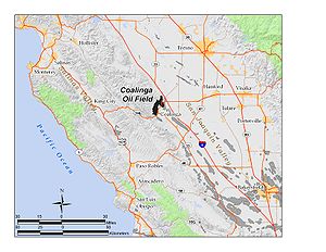
Coalinga Oil Field
Encyclopedia
Oil field
An oil field is a region with an abundance of oil wells extracting petroleum from below ground. Because the oil reservoirs typically extend over a large area, possibly several hundred kilometres across, full exploitation entails multiple wells scattered across the area...
in western Fresno County, California
Fresno County, California
Fresno County is a county located in the Central Valley of the U.S. state of California, south of Stockton and north of Bakersfield. As of the 2010 census, it is the tenth most populous county in California with a population of 930,450, and the sixth largest in size with an area of . The county...
, in the United States. It surrounds the town of Coalinga
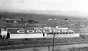
Coalinga, California
Coalinga is a city in Fresno County, California. The population was 13,380 at the 2010 census, up from 11,668 at the 2000 census. It is the site of both Pleasant Valley State Prison and Coalinga State Hospital. Coalinga is located southwest of Fresno, at an elevation of 673 feet .-Early...
, about half-way between Los Angeles
Los Ángeles
Los Ángeles is the capital of the province of Biobío, in the commune of the same name, in Region VIII , in the center-south of Chile. It is located between the Laja and Biobío rivers. The population is 123,445 inhabitants...
and San Francisco, to the west of Interstate 5
Interstate 5
Interstate 5 is the main Interstate Highway on the West Coast of the United States, running largely parallel to the Pacific Ocean coastline from Canada to Mexico . It serves some of the largest cities on the U.S...
, at the foot of the Diablo Range
Diablo Range
The Diablo Range is a mountain range in the California Coast Ranges subdivision of the Pacific Coast Ranges. It is located in the eastern San Francisco Bay area south to the Salinas Valley area of northern California, the United States.-Geography:...
. Discovered in the late 19th century, it became active around 1890, and is now the eighth-largest oil field in California, with reserves totaling approximately 58 Moilbbl, and over 1,600 active oil wells. The principal operators on the field, as of 2008, were Chevron Corp. (formerly Standard Oil of California or SoCal) and Aera Energy LLC
Aera Energy LLC
Aera Energy LLC is a natural gas, oil exploration and production company jointly owned by Shell and ExxonMobil headquartered in Bakersfield, California...
.
Setting
Compared to many of the other California oil fields, Coalinga is large and spread out, but contains a few areas of concentrated development around the richer pools. The field has a rough semicircular shape open to the southeast, approximately twelve miles long by six across, with the town of Coalinga at the southwestern limit of the semicircle, and the agricultural Pleasant Valley inside. The oil field is mainly on the high ground around the valley, with the western part of the semicircle at the base of the Alcalde Hills, and the eastern part on the long and low Anticline Ridge, which separates Pleasant Valley and Coalinga from Interstate 5Interstate 5
Interstate 5 is the main Interstate Highway on the West Coast of the United States, running largely parallel to the Pacific Ocean coastline from Canada to Mexico . It serves some of the largest cities on the U.S...
and the main part of the San Joaquin Valley
San Joaquin Valley
The San Joaquin Valley is the area of the Central Valley of California that lies south of the Sacramento – San Joaquin River Delta in Stockton...
. The anticline
Anticline
In structural geology, an anticline is a fold that is convex up and has its oldest beds at its core. The term is not to be confused with antiform, which is a purely descriptive term for any fold that is convex up. Therefore if age relationships In structural geology, an anticline is a fold that is...
in Anticline ridge continues to the southeast as the Guijarral Hills Oil Field
Guijarral Hills Oil Field
The Guijarral Hills Oil Field is a formerly-productive oil and gas field near Coalinga on the western side of the Central Valley in central California in the United States...
and the Kettleman North Dome Oil Field
Kettleman North Dome Oil Field
The Kettleman North Dome Oil Field is a large oil and gas field in Kings and Fresno Counties, California. Discovered in 1928, it is fifteenth largest field in the state by total ultimate oil recovery, and of the top twenty oil fields it is the closest to exhaustion, with less than one-half of one...
. California State routes 33
California State Route 33
State Route 33 is a north–south state highway in the U.S. state of California. SR 33 replaced part of U.S. Route 399 in 1964 during the "great renumbering" of routes. In the unincorporated sections of Kern County it is known as the West Side Highway...
and 198
California State Route 198
State Route 198 is an east–west state highway that connects the California Central Coast to the mid-Central Valley at Visalia, although the most-traveled portion is in the Central Valley itself....
, which join together for the stretch through and north of Coalinga, cut across the Coalinga field and cross Anticline Ridge; along the route a passing traveler has a good view of oil field operations.
As the climate in the region is semiarid to arid, most of the native vegetation is grassland and low scrub. Areas of particularly dense oil development are almost entirely denuded of vegetation.
Geology and operations
Lost Hills Oil Field
The Lost Hills Oil Field is a large oil field in the Lost Hills Range, north of the town of Lost Hills in western Kern County, California, in the United States.-Production:...
, South Belridge
South Belridge Oil Field
The South Belridge Oil Field is a large oil field in northwestern Kern County, San Joaquin Valley, California, about forty miles west of Bakersfield...
, Kettleman Hills, and Cymric
Cymric Oil Field
The Cymric Oil Field is a large oil field in Kern County, California in the United States. While only the 14th-largest oil field in California in total size, in terms of total remaining reserves it ranks fifth, with the equivalent of over still in the ground...
fields. The southernmost, and largest in the series, is the Midway-Sunset Field
Midway-Sunset Oil Field
The Midway-Sunset Oil Field is a large oil field in Kern County, San Joaquin Valley, California in the United States. Discovered in 1894, and having a cumulative production of close to of oil at the end of 2006, it is the largest oil field in California and the third largest in the United States....
in the southwestern corner of the valley.
The eastern part of the Coalinga field is a southeast-plunging anticline. Most of the oil in the Coalinga field comes from a large-scale geologic formation known as the Kregenhagan-Temblor petroleum system, a body of Eocene
Eocene
The Eocene Epoch, lasting from about 56 to 34 million years ago , is a major division of the geologic timescale and the second epoch of the Paleogene Period in the Cenozoic Era. The Eocene spans the time from the end of the Palaeocene Epoch to the beginning of the Oligocene Epoch. The start of the...
-age shales rich in organic sediments. Oil in the field is found in both structural traps such as anticlinal
Anticline
In structural geology, an anticline is a fold that is convex up and has its oldest beds at its core. The term is not to be confused with antiform, which is a purely descriptive term for any fold that is convex up. Therefore if age relationships In structural geology, an anticline is a fold that is...
folds, in which oil migrates upwards and is trapped beneath an impermeable layer, and stratigraphic traps, where oil is trapped within a rock unit due to changes within the rock itself.
Drillers have found a total of four oil pools in the Coalinga field. The first to be discovered was the "Oil City" pool of Cretaceous
Cretaceous
The Cretaceous , derived from the Latin "creta" , usually abbreviated K for its German translation Kreide , is a geologic period and system from circa to million years ago. In the geologic timescale, the Cretaceous follows the Jurassic period and is followed by the Paleogene period of the...
age, discovered in 1887 or 1888; however, it had little yield. On the east side of the field, along Anticline Ridge, the huge Temblor pool of Miocene
Miocene
The Miocene is a geological epoch of the Neogene Period and extends from about . The Miocene was named by Sir Charles Lyell. Its name comes from the Greek words and and means "less recent" because it has 18% fewer modern sea invertebrates than the Pliocene. The Miocene follows the Oligocene...
age, at depths of 700 to 4600 feet (1,402.1 m), produced an enormous amount of oil in the early 20th century, and is now mostly exhausted. The other large pool is the Etchegoin-Temblor on the west side, of Pliocene
Pliocene
The Pliocene Epoch is the period in the geologic timescale that extends from 5.332 million to 2.588 million years before present. It is the second and youngest epoch of the Neogene Period in the Cenozoic Era. The Pliocene follows the Miocene Epoch and is followed by the Pleistocene Epoch...
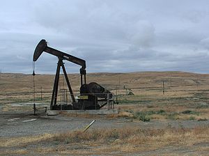
-Miocene age, and at depths of 500 to 3500 feet (1,066.8 m); this area is currently active and subject to enhanced recovery methods such as steam flooding, fire flooding, and water flooding, methods developed in recent decades in order to extract previously submarginal deposits.
The Coalinga Oil Field is a mature field, and closer to exhaustion than most of the other major fields in California. Its remaining reserves, at around 58000000 barrels (9,221,263.1 m³), are less than 6 percent of its total original capacity; over 912 Moilbbl of oil have been pumped from the field since the late 19th century. In the San Joaquin Valley, only the Buena Vista Oil Field
Buena Vista Oil Field
The Buena Vista Oil Field, formerly the Naval Petroleum Reserve No. 2 is a large oil field in Kern County, San Joaquin Valley, California in the United States. Discovered in 1909, and having a cumulative production of approximately , it is the tenth-largest oil field in California...
and Kettleman North Dome Oil Field
Kettleman North Dome Oil Field
The Kettleman North Dome Oil Field is a large oil and gas field in Kings and Fresno Counties, California. Discovered in 1928, it is fifteenth largest field in the state by total ultimate oil recovery, and of the top twenty oil fields it is the closest to exhaustion, with less than one-half of one...
are closer to exhaustion, with about one percent and one-half of one percent of their original oil remaining, respectively.
Oil from the Etchegoin-Temblor pool on the westside is heavy crude, with a specific gravity of 11-18 API
API gravity
The American Petroleum Institute gravity, or API gravity, is a measure of how heavy or light a petroleum liquid is compared to water. If its API gravity is greater than 10, it is lighter and floats on water; if less than 10, it is heavier and sinks...
, and a relatively low sulfur content of 0.75%; oil from the Temblor pools on the Eastside is more variable, ranging from heavy to medium crude, having an API index of 12 to 30.
Aera Energy, LLC sends its oil from the Coalinga field to its refinery in Martinez
Martinez, California
Martinez is a city and the county seat of Contra Costa County, California, United States. The population was 35,824 at the 2010 census. The downtown is notable for its large number of preserved old buildings...
for processing.
History
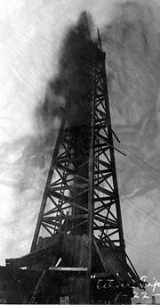
In 1890 the first oil boom began, once the Southern Pacific had extended its rail line into the town of Coalinga. Around the "Oil City" area of the Coalinga Field, directly north of the modern-day town of Coalinga, several large gushers attracted attention, gushers still being a relatively new occurrence in the oil industry. The "Blue Goose" well, drilled by the Home Oil Company to a depth 1400 feet (426.7 m), erupted in 1898, spewing over 1000 oilbbl/d.
The huge and productive Temblor oil pools were discovered around 1900, and by 1910 the field was the most richly productive oil field in California, exceeding those in the Los Angeles Basin for the first time. A dramatic oil gusher in 1909 at the "Silver Tip" well, the biggest gusher in California until then, was an event of such excitement that Los Angeles Stock Exchange
Pacific Exchange
The Pacific Exchange was, until 2001, a regional stock exchange with a main exchange floor and building in San Francisco, California, USA and a branch in Los Angeles, California, USA. Its history began with the founding of the San Francisco Stock and Bond Exchange in 1882 and the Los Angeles Oil...
closed down for a day so that its members could come by train to view it. This gusher would be dwarfed a year later by the colossal Lakeview Gusher
Lakeview Gusher
Lakeview Gusher Number One was an immense out-of-control pressurized oil well in the Midway-Sunset Oil Field in Kern County, California, resulting in what is the largest single oil spill in history, lasting 18 months and releasing of crude oil. In what was one of the largest oil reserves in...
, by which California's largest oil field, the Midway-Sunset
Midway-Sunset Oil Field
The Midway-Sunset Oil Field is a large oil field in Kern County, San Joaquin Valley, California in the United States. Discovered in 1894, and having a cumulative production of close to of oil at the end of 2006, it is the largest oil field in California and the third largest in the United States....
in Kern County, was first known.
In the early years of the field, competition was fierce between different oil companies, with a particularly sharp conflict between a group of independent oil producers and Standard Oil
Standard Oil
Standard Oil was a predominant American integrated oil producing, transporting, refining, and marketing company. Established in 1870 as a corporation in Ohio, it was the largest oil refiner in the world and operated as a major company trust and was one of the world's first and largest multinational...
, which operated as a gigantic trust until its breakup by the U.S. Supreme Court in 1911. According to an article published in the New York Times in 1905, Standard attempted to force its competitors out of business by artificially holding down the price of oil to as little as ten cents a barrel. The Coalinga independents responded by building a pipeline to San Francisco Bay, the construction of which was itself obstructed by continuous harassment from Standard, until the independents were finally successful by ruse: secretly building a real pipeline, while simultaneously seeming to work on a "dummy" pipeline in a more prominent location. During this time, the independent operators also accused the Southern Pacific Railroad
Southern Pacific Railroad
The Southern Pacific Transportation Company , earlier Southern Pacific Railroad and Southern Pacific Company, and usually simply called the Southern Pacific or Espee, was an American railroad....
of working in conjunction with Standard to put them out of business.
The operators of the Coalinga field attained peak production in 1912 – 19500000 barrels (3,100,252.3 m³) of oil – a value which was to decline steadily for the next several decades.
During the 1960s and 1970s, enhanced recovery technologies
Enhanced oil recovery
Enhanced Oil Recovery is a generic term for techniques for increasing the amount of crude oil that can be extracted from an oil field...
such as water flooding, steam flooding, fire flooding, and polymer flooding were employed to increase the declining productivity of the field, and to reach and recover previously submarginal deposits. Even with such methods, the current oil output of the field has declined considerably from the early part of the 20th century: in 2006, the field's operators reported 5700000 barrels (906,227.6 m³) of oil pumped.
External links
- 100 Years of Oil, from the Bakersfield Californian: stories about San Joaquin Valley oilfields
- Approximate center of the field, in Google Maps