

Buena Vista Oil Field
Encyclopedia
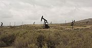
The Buena Vista Oil Field, formerly the Naval Petroleum Reserve No. 2 (NPR-2) is a large oil field
in Kern County
, San Joaquin Valley
, California
in the United States
. Discovered in 1909, and having a cumulative production of approximately 667 Moilbbl, it is the tenth-largest oil field in California. It is also one of the closest to being exhausted, having a total reserve of only about one percent of its original oil, and having produced a mere 713000 barrels (113,357.9 m³) in 2006.
is adjacent to the southwest, about halfway along the field. The oil field underlies the Buena Vista Hills, a low range with a maximum elevation of 1300 feet (396.2 m), in their entirety, and the Buena Vista Front Area is mostly in the Buena Vista Valley, which separates the Buena Vista Hills from the larger Elk Hills range to the north. State Route 33
parallels the Buena Vista Field about two miles (3 km) to the southwest, and State Route 119
cuts across the field to the northeast, towards Bakersfield.
Many oil fields underlie the southwestern portion of Kern County. Adjacent to the Buena Vista field to the southwest is the enormous Midway-Sunset Oil Field
, the largest in California and third-largest in the United States, and just north of the Buena Vista field is the Elk Hills Oil Field
, famous in American history as one of the illicit leases that brought corruption charges upon the administration of Warren G. Harding.
Until January 1, 1958, the Buena Vista field was considered to be part of the larger Midway-Sunset Field to the southwest; now, however, the two are considered to be geologically separate.
 As with many of the fields in the San Joaquin Valley, the Buena Vista field is predominantly an anticline
, with pools of oil trapped in rock units beneath impermeable layers. Some of the oil pools are in dome
s and anticlinal formations, and others are trapped in rock units due to movement of fault
s. The age of most of the rock units containing oil varies from Pliocene
(Etchegoin Formation), the most recent, to Miocene
(Monterey
and Santa Margarita Formations), the most ancient, and oil has been recovered at depths from about 2300 feet (701 m) to 5300 feet (1,615.4 m). The deepest well on the field was drilled by the Honolulu Oil Corp. to a depth of 14622 feet (4,456.8 m), reaching the Santos unit of Oligocene
age. No economically recoverable oil was found at this depth.
In the Front Area, the less productive part of the oil field, most of the oil comes from depths of around 4000 feet (1,219.2 m), from the San Joaquin and Etchegoin formations. These pools were discovered in 1912, peak production was in 1925, waterflooding was attempted in the 1960s, and with most of the oil having been removed, today most operations have ceased. The Main Area of the Buena Vista Oil Field is still active, with enhanced recovery technologies such as gas injection still continuing. Peak production in the Main Area was in 1947, and has fallen off steadily since.
Most of the oil produced from the Buena Vista field is medium crude, with specific gravity
of approximately 18 to 36 API
. One of the geologic units, the "Mya Gas", discovered in 1909, produces only natural gas; its year of peak production was 1919. The discovery well for the field was in this unit, and it was the abundant presence of natural gas that convinced drillers to keep looking, as where gas was found, typically oil would be as well.
While much of the field has been abandoned, there is at least one active prospect adjacent to the old field. An Australian company, Salinas Energy, is currently studying the possibility of commencing production.
Oil field
An oil field is a region with an abundance of oil wells extracting petroleum from below ground. Because the oil reservoirs typically extend over a large area, possibly several hundred kilometres across, full exploitation entails multiple wells scattered across the area...
in Kern County
Kern County, California
Spreading across the southern end of the California Central Valley, Kern County is the fifth-largest county by population in California. Its economy is heavily linked to agriculture and to petroleum extraction, and there is a strong aviation and space presence. Politically, it has generally...
, San Joaquin Valley
San Joaquin Valley
The San Joaquin Valley is the area of the Central Valley of California that lies south of the Sacramento – San Joaquin River Delta in Stockton...
, California
California
California is a state located on the West Coast of the United States. It is by far the most populous U.S. state, and the third-largest by land area...
in the United States
United States
The United States of America is a federal constitutional republic comprising fifty states and a federal district...
. Discovered in 1909, and having a cumulative production of approximately 667 Moilbbl, it is the tenth-largest oil field in California. It is also one of the closest to being exhausted, having a total reserve of only about one percent of its original oil, and having produced a mere 713000 barrels (113,357.9 m³) in 2006.
Setting
The oil field is in two parts, the Buena Vista Hills Area and the Buena Vista Front Area, both roughly linear features about 12 miles (19.3 km) long, running parallel about two miles (3 km) apart, and each being one to two miles (3 km) across, and trending from southeast to northwest. The town of TaftTaft, California
Taft is a city in the foothills at the extreme southwestern edge of the San Joaquin Valley, in Kern County, California. Taft is located west-southwest of Bakersfield, at an elevation of 955 feet . The population was 9,327 at the 2010 census...
is adjacent to the southwest, about halfway along the field. The oil field underlies the Buena Vista Hills, a low range with a maximum elevation of 1300 feet (396.2 m), in their entirety, and the Buena Vista Front Area is mostly in the Buena Vista Valley, which separates the Buena Vista Hills from the larger Elk Hills range to the north. State Route 33
California State Route 33
State Route 33 is a north–south state highway in the U.S. state of California. SR 33 replaced part of U.S. Route 399 in 1964 during the "great renumbering" of routes. In the unincorporated sections of Kern County it is known as the West Side Highway...
parallels the Buena Vista Field about two miles (3 km) to the southwest, and State Route 119
California State Route 119
State Route 119 is a state highway in the U.S. state of California that runs in an east–west direction from State Route 33 in Taft to State Route 99 just south of Bakersfield. SR 119 is part of the former U.S. Route 399, which ran along SR 33 and State Route 166 before ending at SR 99...
cuts across the field to the northeast, towards Bakersfield.
Many oil fields underlie the southwestern portion of Kern County. Adjacent to the Buena Vista field to the southwest is the enormous Midway-Sunset Oil Field
Midway-Sunset Oil Field
The Midway-Sunset Oil Field is a large oil field in Kern County, San Joaquin Valley, California in the United States. Discovered in 1894, and having a cumulative production of close to of oil at the end of 2006, it is the largest oil field in California and the third largest in the United States....
, the largest in California and third-largest in the United States, and just north of the Buena Vista field is the Elk Hills Oil Field
Elk Hills Oil Field
The Elk Hills Oil Field is a large oil field in northwestern Kern County, in the Elk Hills of the San Joaquin Valley, California in the United States, about twenty miles west of Bakersfield...
, famous in American history as one of the illicit leases that brought corruption charges upon the administration of Warren G. Harding.
Until January 1, 1958, the Buena Vista field was considered to be part of the larger Midway-Sunset Field to the southwest; now, however, the two are considered to be geologically separate.
Geology and production
Anticline
In structural geology, an anticline is a fold that is convex up and has its oldest beds at its core. The term is not to be confused with antiform, which is a purely descriptive term for any fold that is convex up. Therefore if age relationships In structural geology, an anticline is a fold that is...
, with pools of oil trapped in rock units beneath impermeable layers. Some of the oil pools are in dome
Dome (geology)
In structural geology, a dome is a deformational feature consisting of symmetrically-dipping anticlines; their general outline on a geologic map is circular or oval...
s and anticlinal formations, and others are trapped in rock units due to movement of fault
Geologic fault
In geology, a fault is a planar fracture or discontinuity in a volume of rock, across which there has been significant displacement along the fractures as a result of earth movement. Large faults within the Earth's crust result from the action of tectonic forces...
s. The age of most of the rock units containing oil varies from Pliocene
Pliocene
The Pliocene Epoch is the period in the geologic timescale that extends from 5.332 million to 2.588 million years before present. It is the second and youngest epoch of the Neogene Period in the Cenozoic Era. The Pliocene follows the Miocene Epoch and is followed by the Pleistocene Epoch...
(Etchegoin Formation), the most recent, to Miocene
Miocene
The Miocene is a geological epoch of the Neogene Period and extends from about . The Miocene was named by Sir Charles Lyell. Its name comes from the Greek words and and means "less recent" because it has 18% fewer modern sea invertebrates than the Pliocene. The Miocene follows the Oligocene...
(Monterey
Monterey Formation
The Monterey Formation is an extensive Miocene oil-rich geological sedimentary formation in California, with massive outcroppings of the formation in areas of the California Coast Ranges, Peninsular Ranges, and on some of California's off-shore islands...
and Santa Margarita Formations), the most ancient, and oil has been recovered at depths from about 2300 feet (701 m) to 5300 feet (1,615.4 m). The deepest well on the field was drilled by the Honolulu Oil Corp. to a depth of 14622 feet (4,456.8 m), reaching the Santos unit of Oligocene
Oligocene
The Oligocene is a geologic epoch of the Paleogene Period and extends from about 34 million to 23 million years before the present . As with other older geologic periods, the rock beds that define the period are well identified but the exact dates of the start and end of the period are slightly...
age. No economically recoverable oil was found at this depth.
In the Front Area, the less productive part of the oil field, most of the oil comes from depths of around 4000 feet (1,219.2 m), from the San Joaquin and Etchegoin formations. These pools were discovered in 1912, peak production was in 1925, waterflooding was attempted in the 1960s, and with most of the oil having been removed, today most operations have ceased. The Main Area of the Buena Vista Oil Field is still active, with enhanced recovery technologies such as gas injection still continuing. Peak production in the Main Area was in 1947, and has fallen off steadily since.
Most of the oil produced from the Buena Vista field is medium crude, with specific gravity
Specific gravity
Specific gravity is the ratio of the density of a substance to the density of a reference substance. Apparent specific gravity is the ratio of the weight of a volume of the substance to the weight of an equal volume of the reference substance. The reference substance is nearly always water for...
of approximately 18 to 36 API
API gravity
The American Petroleum Institute gravity, or API gravity, is a measure of how heavy or light a petroleum liquid is compared to water. If its API gravity is greater than 10, it is lighter and floats on water; if less than 10, it is heavier and sinks...
. One of the geologic units, the "Mya Gas", discovered in 1909, produces only natural gas; its year of peak production was 1919. The discovery well for the field was in this unit, and it was the abundant presence of natural gas that convinced drillers to keep looking, as where gas was found, typically oil would be as well.
While much of the field has been abandoned, there is at least one active prospect adjacent to the old field. An Australian company, Salinas Energy, is currently studying the possibility of commencing production.