

Kenora District, Ontario
Encyclopedia
Kenora District is a district and census division
in Northwestern Ontario
, Canada. It was created in 1907 from parts of Rainy River District
. It is, geographically, the largest division in that province; at 407,192.66 km2 it comprises almost 38 percent of the province's land area. It is larger than Paraguay
and approximately the size of California.
Kenora District also has the lowest population density of any of Ontario's census divisions, although it ranks 38th out of 50 by population.
The district seat is the City of Kenora.
The northern part, north of the Albany River
and known sometimes as the Patricia Portion, became part of Ontario in 1912. It was originally designated as the separate Patricia District, but was added to the Kenora District in 1927.
level of government that exists in Southern Ontario
. All government services in the district are instead provided by the local municipalities, by local services boards in some unincorporated communities, or directly by the provincial government.
is very harsh because of the influence of the cold waters of Hudson
and James
Bay
s: most of the region is taiga
characterized by discontinuous permafrost, but on the extreme northern coast there are – remarkably for a latitude of only 54°N – patches of true Arctic tundra
and continuous permafrost. This is the southernmost point reached by the circumpolar line of continuous permafrost on any continent.
The Kenora District contains the Sturgeon Lake Caldera
, which is one of the world's best preserved Neoarchean
caldera
complexes and is some 2.7 billion years old.
. In the north, mining is extremely extensive: northern Kenora district contains among the largest and highest-grade reserves of uranium
in the world, and is also one of the world's major producers of nickel. Traditional native
activities such as hunting and fishing dominate the northern half of the district outside of the few mining settlements.
A major mining exploration project is currently underway in the Ring of Fire
region, centred on the district's isolated McFaulds Lake
.
) only reach about halfway to the northernmost point of Kenora district, with the provincial highway network ending at Pickle Lake
, although some more northerly communities have access to a seasonal ice
/winter road
network, via the Northern Ontario Resource Trail
. Year-round air and summertime river transport are the only means of reaching the most remote parts of the district. The major railroad lines between Toronto and British Columbia
passes through the south of the district.
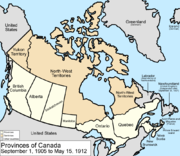 The Patricia Portion is an informal name for the part of the Kenora District lying north of the Albany River
, which was transferred from the Northwest Territories
to Ontario on May 15, 1912 in the Ontario Boundaries Extension Act, 1912. This area was originally a separate division named Patricia District, but became part of Kenora District in 1927.
With the exception of a few communities along the northernmost ends of Highway 599
and the Highway 105
/Highway 125
corridor, the Patricia Portion consists almost entirely of remote First Nations
communities which are only accessible by float plane or winter road
. Accordingly, the name "Patricia Portion" is still sometimes used to distinguish the area from the more populated southern portion of the district.
Census division
Census division is an official term in Canada and the United States. The census divisions of Canada are second-level census geographic unit, below provinces and territories, and above "census subdivisions" and "dissemination areas". In provinces where they exist, the census division may correspond...
in Northwestern Ontario
Northwestern Ontario
Northwestern Ontario is the region within the Canadian province of Ontario which lies north and west of Lake Superior, and west of Hudson Bay and James Bay. It includes most of subarctic Ontario. Its western boundary is the Canadian province of Manitoba, which disputed Ontario's claim to the...
, Canada. It was created in 1907 from parts of Rainy River District
Rainy River District, Ontario
Rainy River District is a district and census division in Northwestern Ontario in the Canadian province of Ontario. It was created in 1885. It is the only division in Ontario that lies completely in the Central time zone. Its seat is Fort Frances...
. It is, geographically, the largest division in that province; at 407,192.66 km2 it comprises almost 38 percent of the province's land area. It is larger than Paraguay
Paraguay
Paraguay , officially the Republic of Paraguay , is a landlocked country in South America. It is bordered by Argentina to the south and southwest, Brazil to the east and northeast, and Bolivia to the northwest. Paraguay lies on both banks of the Paraguay River, which runs through the center of the...
and approximately the size of California.
Kenora District also has the lowest population density of any of Ontario's census divisions, although it ranks 38th out of 50 by population.
The district seat is the City of Kenora.
The northern part, north of the Albany River
Albany River
The Albany River is a river in Northern Ontario, Canada, which flows northeast from Lake St. Joseph in Northwestern Ontario and empties into James Bay. It is long to the head of the Cat River, tying it with the Severn River for the title of longest river in Ontario...
and known sometimes as the Patricia Portion, became part of Ontario in 1912. It was originally designated as the separate Patricia District, but was added to the Kenora District in 1927.
Politics
As with the other districts of Northern Ontario, Kenora District has no equivalent to the county or regional municipalityRegional municipality
A regional municipality is a type of Canadian municipal government similar to and at the same municipal government level as a county, although the specific structure and servicing responsibilities may vary from place to place...
level of government that exists in Southern Ontario
Southern Ontario
Southern Ontario is a region of the province of Ontario, Canada that lies south of the French River and Algonquin Park. Depending on the inclusion of the Parry Sound and Muskoka districts, its surface area would cover between 14 to 15% of the province. It is the southernmost region of...
. All government services in the district are instead provided by the local municipalities, by local services boards in some unincorporated communities, or directly by the provincial government.
Geography
The climateClimate
Climate encompasses the statistics of temperature, humidity, atmospheric pressure, wind, rainfall, atmospheric particle count and other meteorological elemental measurements in a given region over long periods...
is very harsh because of the influence of the cold waters of Hudson
Hudson Bay
Hudson Bay , sometimes called Hudson's Bay, is a large body of saltwater in northeastern Canada. It drains a very large area, about , that includes parts of Ontario, Quebec, Saskatchewan, Alberta, most of Manitoba, southeastern Nunavut, as well as parts of North Dakota, South Dakota, Minnesota,...
and James
James Bay
James Bay is a large body of water on the southern end of Hudson Bay in Canada. Both bodies of water extend from the Arctic Ocean. James Bay borders the provinces of Quebec and Ontario; islands within the bay are part of Nunavut...
Bay
Bay
A bay is an area of water mostly surrounded by land. Bays generally have calmer waters than the surrounding sea, due to the surrounding land blocking some waves and often reducing winds. Bays also exist as an inlet in a lake or pond. A large bay may be called a gulf, a sea, a sound, or a bight...
s: most of the region is taiga
Taiga
Taiga , also known as the boreal forest, is a biome characterized by coniferous forests.Taiga is the world's largest terrestrial biome. In North America it covers most of inland Canada and Alaska as well as parts of the extreme northern continental United States and is known as the Northwoods...
characterized by discontinuous permafrost, but on the extreme northern coast there are – remarkably for a latitude of only 54°N – patches of true Arctic tundra
Tundra
In physical geography, tundra is a biome where the tree growth is hindered by low temperatures and short growing seasons. The term tundra comes through Russian тундра from the Kildin Sami word tūndâr "uplands," "treeless mountain tract." There are three types of tundra: Arctic tundra, alpine...
and continuous permafrost. This is the southernmost point reached by the circumpolar line of continuous permafrost on any continent.
The Kenora District contains the Sturgeon Lake Caldera
Sturgeon Lake Caldera
Sturgeon Lake Caldera is a large extinct caldera complex in Kenora District of Northwestern Ontario, Canada. It is one the world's best preserved mineralized Neoarchean caldera complexes, containing well-preserved mafic-intermediate pillow lavas, pillow breccias, hyaloclastite and peperites,...
, which is one of the world's best preserved Neoarchean
Neoarchean
The Neoarchean is a geologic era within the Archaean. It spans the period of time from —the period being defined chronometrically and not referenced to a specific level in a rock section on Earth...
caldera
Caldera
A caldera is a cauldron-like volcanic feature usually formed by the collapse of land following a volcanic eruption, such as the one at Yellowstone National Park in the US. They are sometimes confused with volcanic craters...
complexes and is some 2.7 billion years old.
Economy
Most of the population of the district is concentrated in the extreme south where some agriculture is possible: the main crop is barleyBarley
Barley is a major cereal grain, a member of the grass family. It serves as a major animal fodder, as a base malt for beer and certain distilled beverages, and as a component of various health foods...
. In the north, mining is extremely extensive: northern Kenora district contains among the largest and highest-grade reserves of uranium
Uranium
Uranium is a silvery-white metallic chemical element in the actinide series of the periodic table, with atomic number 92. It is assigned the chemical symbol U. A uranium atom has 92 protons and 92 electrons, of which 6 are valence electrons...
in the world, and is also one of the world's major producers of nickel. Traditional native
First Nations
First Nations is a term that collectively refers to various Aboriginal peoples in Canada who are neither Inuit nor Métis. There are currently over 630 recognised First Nations governments or bands spread across Canada, roughly half of which are in the provinces of Ontario and British Columbia. The...
activities such as hunting and fishing dominate the northern half of the district outside of the few mining settlements.
A major mining exploration project is currently underway in the Ring of Fire
Northern Ontario Ring of Fire
The Ring of Fire is the name given to an area of muskeg swamps in the James Bay Lowlands located in Northern Ontario, Canada, which is currently home to a major mining exploration project...
region, centred on the district's isolated McFaulds Lake
McFaulds Lake
McFaulds Lake is a lake located in the Unorganized Part of Kenora District in northwestern Ontario, Canada. It is part of the James Bay drainage basin and is in the Hudson Bay Lowlands area...
.
Transportation
Permanent roads (Highway 599Highway 599 (Ontario)
Secondary Highway 599, commonly referred to as Highway 599, is a provincially maintained secondary highway in the Canadian province of Ontario...
) only reach about halfway to the northernmost point of Kenora district, with the provincial highway network ending at Pickle Lake
Pickle Lake, Ontario
Pickle Lake is a township in the Canadian province of Ontario, and is the most northerly community in the province that has year-round access by road. Located north of Thunder Bay, highway access is via Highway 599, the only access road to the town from the south. More northerly communities rely...
, although some more northerly communities have access to a seasonal ice
Ice road
Ice roads are frozen, human-made structures on the surface of bays, rivers, lakes, or seas in the far north. They link dry land, frozen waterways, portages and winter roads, and are usually remade each winter. Ice roads allow temporary transport to areas with no permanent road access...
/winter road
Winter road
Winter roads are temporary highways carved out of snow and ice. They facilitate transportation to and from communities without permanent roads, and are commonly seen in isolated regions in Canada's north....
network, via the Northern Ontario Resource Trail
Northern Ontario Resource Trail
The Northern Ontario Resource Trail is a mainly gravel road in the Canadian province of Ontario, which travels north from Pickle Lake to the northern shore of Windigo Lake...
. Year-round air and summertime river transport are the only means of reaching the most remote parts of the district. The major railroad lines between Toronto and British Columbia
British Columbia
British Columbia is the westernmost of Canada's provinces and is known for its natural beauty, as reflected in its Latin motto, Splendor sine occasu . Its name was chosen by Queen Victoria in 1858...
passes through the south of the district.
Patricia Portion
Albany River
The Albany River is a river in Northern Ontario, Canada, which flows northeast from Lake St. Joseph in Northwestern Ontario and empties into James Bay. It is long to the head of the Cat River, tying it with the Severn River for the title of longest river in Ontario...
, which was transferred from the Northwest Territories
Northwest Territories
The Northwest Territories is a federal territory of Canada.Located in northern Canada, the territory borders Canada's two other territories, Yukon to the west and Nunavut to the east, and three provinces: British Columbia to the southwest, and Alberta and Saskatchewan to the south...
to Ontario on May 15, 1912 in the Ontario Boundaries Extension Act, 1912. This area was originally a separate division named Patricia District, but became part of Kenora District in 1927.
With the exception of a few communities along the northernmost ends of Highway 599
Highway 599 (Ontario)
Secondary Highway 599, commonly referred to as Highway 599, is a provincially maintained secondary highway in the Canadian province of Ontario...
and the Highway 105
Highway 105 (Ontario)
King's Highway 105, commonly referred to as Highway 105, is a provincially maintained highway in the Canadian province of Ontario.Its history is traced to the discovery of gold and the opening of gold mines in the area around Red Lake in 1926...
/Highway 125
Highway 125 (Ontario)
King's Highway 125, commonly referred to as Highway 125, is a provincially maintained highway in the Canadian province of Ontario. It is the second northernmost provincial highway in Ontario, behind Secondary Highway 599...
corridor, the Patricia Portion consists almost entirely of remote First Nations
First Nations
First Nations is a term that collectively refers to various Aboriginal peoples in Canada who are neither Inuit nor Métis. There are currently over 630 recognised First Nations governments or bands spread across Canada, roughly half of which are in the provinces of Ontario and British Columbia. The...
communities which are only accessible by float plane or winter road
Winter road
Winter roads are temporary highways carved out of snow and ice. They facilitate transportation to and from communities without permanent roads, and are commonly seen in isolated regions in Canada's north....
. Accordingly, the name "Patricia Portion" is still sometimes used to distinguish the area from the more populated southern portion of the district.
Townships
- Ear FallsEar Falls, OntarioEar Falls is a small settlement and township located in Northwestern Ontario, Canada, on the right bank of the English River near the outlet of Lac Seul...
- IgnaceIgnace, OntarioIgnace is a township in the Kenora District of Northwestern Ontario, Canada, located at Highway 17 and Secondary Highway 599, and on the Canadian Pacific Railway between Thunder Bay and Kenora. It is on the shore of Agimak Lake, and, as of 2006, the population of Ignace was 1,431.The town was...
- MachinMachin, OntarioMachin is a township in the Canadian province of Ontario, located in the Kenora District west of Dryden.The main communities in Machin township are Eagle River, Minnitaki, and Vermilion Bay...
- Pickle LakePickle Lake, OntarioPickle Lake is a township in the Canadian province of Ontario, and is the most northerly community in the province that has year-round access by road. Located north of Thunder Bay, highway access is via Highway 599, the only access road to the town from the south. More northerly communities rely...
- Sioux Narrows-Nestor FallsSioux Narrows-Nestor Falls, OntarioPopulation trend:* Population in 2006: 672* Population in 2001: 577* Population total in 1996: 794** Sioux Narrows : 430* Population in 1991:** Sioux Narrows : 390-External links:*...
First Nations reserves
- AttawapiskatAttawapiskat First NationAttawapiskat First Nation is an isolated First Nation located in Kenora District in northern Ontario, Canada, at the mouth of the Attawapiskat River at James Bay...
- Bearskin LakeBearskin Lake First NationBearskin Lake First Nation is an Oji-Cree First Nation in the Canadian province of Ontario, located in the Kenora District 425 kilometres north of Sioux Lookout. Bearskin First Nation's total registered population in September, 2007, was 831, of which their on-reserve population was 423.Three...
- Cat LakeCat Lake First NationCat Lake First Nation is an Ojibwa community approximately 180 kilometres northwest of Sioux Lookout in northwestern Ontario. Wasaya Airways run daily on regular schedules. Winter/ice roads also connects from Pickle Lake, Ontario, via Northern Ontario Resource Trail during the winter months, which...
- Deer LakeDeer Lake First NationDeer Lake First Nation is an Oji-Cree First Nation in Northern Ontario, located north of Red Lake, Ontario. It is one of the few First Nations in Ontario to have signed Treaty 5. It is part of the Keewaytinook Okimakanak Council and the Nishnawbe Aski Nation...
- EabametoongEabametoong First NationEabametoong, also known as Fort Hope, is an Ojibway First Nation in Kenora District, Ontario, Canada. Located on the shore of Eabamet Lake in the Albany River system, the community is located approximately 300 kilometres northeast of Thunder Bay and is accessible only by airplane to Fort Hope...
- Eagle Lake 27
- English River 21
- Fort Albany 67 (part)
- Fort Severn 89
- Islington 29
- KasabonikaKasabonika First NationKasabonika Lake First Nation or Kasabonika First Nation is an Oji-Cree First Nation located north of Sioux Lookout, Ontario. There are no roads into the community and the only access is through Kasabonika Airport...
- KeewaywinKeewaywin First NationKeewaywin is a small Oji-Cree community in Northern Ontario, located north of Red Lake, Ontario. It is connected to Sandy Lake First Nation by Sandy Lake. It is part of the Keewaytinook Okimakanak Council and the Nishnawbe Aski Nation...
- Kenora 38B
- Kingfisher LakeKingfisher First NationKingfisher First Nation is an Oji-Cree First Nation located north of Sioux Lookout, Ontario. It is accessible by air all year round, waterways during summer and ice roads in winter...
- Kitchenuhmaykoosib InninuwugKitchenuhmaykoosib Inninuwug First NationKitchenuhmaykoosib Inninuwug , also known as Big Trout Lake First Nation or KI for short, is a First Nations community in Northwestern Ontario. Part of Treaty 9...
- Lac SeulLac Seul First NationLac Seul First Nation is located on the southeastern shores of Lac Seul, northeast of the city of Dryden, Ontario. Though Lac Seul First Nation is a treaty signatory to Treaty 3, the First Nation is a member of the Independent First Nations Alliance, a regional tribal council and a member of the...
- Lake of the Woods 31G
- Lake of the Woods 37
- Marten FallsMarten Falls First NationMarten Falls First Nation is an Anishinaabe First Nation located in northern Ontario. The First Nation occupies communities on both sides of the Albany River in Northern Ontario, including Ogoki Post in the Cochrane District and Marten Falls in the Kenora District...
- MishkeegogamangMishkeegogamang First NationMishkeegogamang First Nation, also known as New Osnaburgh, Osnaburgh House, Osnaburgh or "Oz" for short, is an Ojibwa First Nation in the Canadian province of Ontario. It is located on Highway 599 in the Kenora District, approximately 20 kilometres south of Pickle Lake...
- Muskrat Dam LakeMuskrat Dam Lake First NationThe Muskrat Dam Lake First Nation is an Oji-Cree First Nation in Northern Ontario. They reside on the Muskrat Dam Lake reserve, located on Muskrat Dam Lake in the Kenora District. The community of Muskrat Dam, Ontario, is located on this reserve...
- Neskantaga
- Northwest Angle 33Northwest Angle 33 First NationNorthwest Angle 33 First Nation is an Ojibwa or Ontario Saulteaux First Nation located in Kenora District, Ontario near Sioux Narrows of Lake of the Woods.Total registered population in September, 2007, was 438, of which the on-reserve population was 187...
- North Spirit LakeNorth Spirit Lake First NationNorth Spirit Lake First Nation is a small Oji-Cree community in Northern Ontario, located north of Red Lake, Ontario. It is connected to Sandy Lake First Nation, and Deer Lake First Nation by winter/ice roads...
- PikangikumPikangikum First NationThe Pikangikum First Nation is an Ojibwe First Nation located on the Pikangikum 14 Reserve, in Unorganized Kenora District in Northwestern Ontario, Canada...
- Poplar Hill
- Rat Portage 38A
- Sabaskong Bay 35D
- Sachigo LakeSachigo Lake First NationSachigo Lake First Nation is an Oji-Cree First Nation in Unorganized Kenora District in Northwestern Ontario, Canada. It is located on Sachigo Lake, part of the Sachigo River system and Hudson Bay drainage basin, approximately north of the town of Sioux Lookout...
- Sandy LakeSandy Lake First NationSandy Lake First Nation is an independent Oji-Cree First Nation. The First Nation community, in the west part of Northern Ontario, is located in the Kenora District, northeast of Red Lake, Ontario. Its registered population in June 2007 was 2,474...
- Shoal Lake 39A (part)
- Shoal Lake 40 (part)
- Shoal Lake 34B2
- The Dalles 38C
- Wabauskang 21
- Wabigoon Lake
- WapekekaWapekeka First NationWapekeka First Nation is a First Nation in the Canadian province of Ontario. An Oji-Cree community in the Kenora District, the community is located approximately 450 kilometres northeast of Sioux Lookout...
- Wawakapewin
- Weagamow Lake 87
- Whitefish Bay 32A
- Whitefish Bay 33A
- Whitefish Bay 34A
- Wunnumin LakeWunnumin Lake First NationWunnumin Lake First Nation is an Oji-Cree First Nation located 360 km northeast of Sioux Lookout in Ontario, Canada...
First Nations settlements
- Frenchman's Head
- Kejick Bay
- Lansdowne House
- MacDowell LakeMcDowell Lake First NationMcDowell Lake First Nation is a small Oji-Cree First Nation located in Northern Ontario, located approximately 155 km northeast of Red Lake, Ontario, Canada, on the central western shore of McDowell Lake. As of December, 2007, their total registered population was 52...
- Muskrat Dam
- PeawanuckPeawanuck, OntarioPeawanuck is an isolated Cree community in the Kenora District, Ontario, Canada. It is located near the confluence of the Winisk and Shamattawa Rivers, about 35 km from the Winisk River's end in Hudson Bay. Its population is 139 ....
- Slate Falls
- Summer Beaver
- Webequie
- Whitefish Bay