

Kalibangan
Encyclopedia
Kalibangān is a town located at 29.47°N 74.13°E on the left or southern banks of the Ghaggar (Ghaggar-Hakra River
), identified by some scholars with Sarasvati River
in Tehsil Pilibangān, between Suratgarh and Hanumāngarh in Hanumangarh
district, Rajasthan
, India
205 km. from Bikaner. The prehistoric and pre-Mauryan character of Indus Valley Civilization
was first identified by Luigi Tessitori
at this site. Kalibangan's excavation report was published in its entirety in 2003 by the Archaeological Survey of India
, 34 years after the completion of excavations. The report concluded that Kalibangan was a major provincial capital of the Indus Valley Civilization. Kalibangan is distinguished by its unique fire altars and "world's earliest attested ploughed field".
 The identity of Kalibangan as a pre-historic site was discovered by Luigi Pio Tessitori, an Italian Indologist (1887–1919) . He was doing some research in ancient Indian texts. He was surprised by the character of ruins in that area, and he sought help from Sir John Marshall
of the Archaeological Survey of India
. At that time ASI had some excavations done on Harappa, but they never had any idea about the character of the ruins. In fact, Tessitori is the first person to recognize that the ruins are 'Prehistoric' and pre-Mauryan. Luigi Pio Tessitori also pointed out the nature of the culture, but at that time it was not possible to guess that Indus Valley Civilisation lay in the ruins of Kalibangan, and he died five years before Harappan culture was duly recognized.
After India's independence, both the major Harappan cities together with the Indus became a part of Pakistan and Indian archaeologists were compelled to intensify the search for Harappan sites in India. Amlānand Ghosh (Ex. Director General, Archaeological Survey of India, or ASI) was the first person to recognise this site as Harappan and marked it out for excavations.. Under the leadership of B. B. Lal
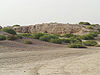
(then Director General, ASI), Balkrishna (B.K.) Thapar, M. D. Khare, K. M. Shrivastava and S. P. Jain carried out excavations for 9 years (1960-9) in 9 successive excavation sessions. Two ancient mounds were excavated, spread over half kilometre (area quarter square kilometer). On western side is the smaller mound (KLB1), 9 meters high and known as citadel. Eastern mound is higher(12 meters) and bigger, known as lower city (KLB2).
The excavation unexpectedly brought to light a twofold sequence of cultures, of which the upper one (Kalibangan I) belongs to the Harappan, showing the characteristic grid layout of a metropolis and the lower one (Kalibangan II) was formerly called pre-Harappan but now it is called "Early Harappan or antecedent Harappan".
age (3500 BC - 2500 BC) to the Harappan age (2500 BC - 1750 BC). This earlier phase is labelled Kalibangan-I (KLB-I) or Period-I.Similarity of pottery relates Kalibangan-I with the Sothi culture because this type of pottery was first discovered at Sothi village in North Western India.
 In this phase, the settlement was fortified, using dried mud bricks, from the beginning of occupation. This fort had been built twice in different periods. Earlier, fort wall had a thickness of 1.9 meters, which was raised to 3.7-4.1 meters during reconstruction in this phase. Brick size was 20 x 20 x 10 cm in both construction-phases. The citadel mound (smaller mound) is a parallelogram about 130 meters on the east-west axis and 260 meters on the north-south. Town planning was like that of Mohenjodaro or Harappa
. The direction of houses and brick sizes was markedly different from that used in the Harappan phase (KLB-II).
Within the walled area, the houses were also built of mud bricks of the same size as used in the fort wall; the use of burnt bricks is attested by a drain within the houses, remains of ovens and cylindrical pits, lined with lime plaster. Some burnt wedge shaped bricks also have been found .
, former DG of ASI, said : "Kalibangan in Rajasthan has given the evidence of the earliest (ca. 2800 BC) ploughed agricultural field ever revealed through an excavation.". It has been found south east of the pre-Harappan settlement, outside the fort. "Kalibangan excavations in present western Rajasthan shows a ploughed field, the first site of this nature in the world. It shows a grid pattern of furrows, placed about 30 cm apart running east-west and other spaced about 190 cm apart running north-south, a pattern remarkably similar to the one practiced even now.". Even today, similar ploughing is used for two simultaneous crops in this region, esp. of mustard and gram. For preservation , this excavated ploughed field area was refilled after excavation and the area was marked by concrete pillar posts.
Fabrics A, B, and D can be clubbed together. They are red painted. Fabric-A is carelessly potted in spite of use of potter's wheel. It contains designs in light-black, often decorated with white lines. Lines, semicircles, grids, insects, flowers, leaves, trees and squares were favorite motifs. Fabric-B shows marked improvement in finishing, but the lower half was deliberately roughened. Flowers, animals were painted in black on red background.
Fabric-D contained designs of slanted lines or semicircles in some, while most pots were plain. But Fabric-C pottery was thicker and stronger. Fabric-C was distinguished by violet tinge and fine polish, with designs in black; it is the best proto-Harappan pottery in finishing. Fabric-E was light colored and Fabric-F was grey..
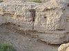
KLB-I phase has left 1.6 meters of continuous deposits during five distinct structural strata, the last of which was destroyed perhaps by an earthquake and the site was abandoned around 2600 BCE, soon to be settled again by Harappans.
which S.R. Rao thinks could have served no other purpose than a ritualistic one . These altars suggest fire worship or worship of Agni
, the Hindu god of fire. It is the only Indus Valley Civilization site where there is no evidence to suggest the worship of the "mother goddess".
Within the fortified citadel complex, the southern half contained many (five or six) raised platforms of mud bricks, mutually separated by corridors. Stairs were attached to these platforms. Vandalism of these platforms by brick robbers makes it difficult to reconstruct the original shape of structures above them but unmistakable remnants of rectangular or oval s (Kunda
s) or fire-pits of burnt bricks for Vedi (altar)
s have been found, with a yūpa or sacrificial post (cylindrical or with rectangular cross-section, sometimes bricks were laid upon each other to construct such a post) in the middle of each and sacrificial terracotta cakes in all these fire-pits. Houses in the lower town also contain similar altars. Burnt charcoals have been found in these fire-pits. The structure of these fire-altars is reminiscent of (Vedic) fire-altars, but the analogy may be coincidental, and these altars are perhaps intended for some specific (perhaps religious) purpose by the community as a whole. In some fire-altars remnants of animals have been found, which suggest a possibility of animal-sacrifice..
The official website of ASI reports : "Besides the above two principle parts of the metropolis there was also a third one-a moderate structure situated upwards of 8O m e. of the lower town containing four to five fire altars. This lonely structure may perhaps have been used for ritual purposes ." Thus, fire-altars have been found in three groups : public altars in the citadel, household altars in lower town, and public altars in a third separate group.
B. B. Lal wrote :"Well-regulated streets (were) oriented almost invariably along with the cardinal directions, thus forming a grid-iron pattern. (At Kalibangan) even the widths of these streets were in a set ratio, i.e. if the narrowest lane was one unit in width, the other streets were twice, thrice and so on. (...) Such a town-planning was unknown in contemporary West Asia.".
The lower town was 239 meters east to west, but north-south extent cannot be determined. 8 main roads have been recognized, 5 north-south and 3 east-west. Few more east-west roads are expected to be buried within the unexcavated remains. Second east-west road ran in a curved outline to meet the first at the north-eastern end (towards the river), where a gateway was provided. This road was an anomaly in the grid-pattern of straight roads. There were many lanes connected to specific housing complexes. Roads and lanes had widths in accurately determined proportions, like in other Harappan cities, ranging from 7.2 meters for main roads to 1.8 meters for narrow lanes. Fender posts were installed at street corners to prevent accidents. In second structural level, roads were laid with mud tiles. Drains from houses emptied into pits (soakage jars) beneath the roads. Some central authority must be there to plan and regulate all this .
Kalibangan 1953 A. Ghosh Situated in Rajasthan on the Bank of Ghaggar
1. Shows both Pre Harappan and Harappan phase
2. Evidence of furrowed land
3. Evidence of camel bones
4. Many houses had their own well
5. Kalibangan stand for black bangles
6. Evidence of wooden furrow
 Three systems of burial have been attested in the burial ground ~300 yards south-west of the citadel, where ~34 graves have been found :
, means black and "bangan" means bangles). Few miles downstream is the railway station and township named Pilibangā, which means Yellow Bangles.
ASI set up a Archaeological Museum at Kālibangan in 1983 to store the excavated materials here during 1961-69. In one gallery, Pre-Harappan finds are displayed, while Harappan finds are displayed in the other two galleries.
Ghaggar-Hakra River
The Ghaggar-Hakra River is an intermittent river in India and Pakistan that flows only during the monsoon season. The river is known as Ghaggar before the Ottu barrage and as the Hakra downstream of the barrage...
), identified by some scholars with Sarasvati River
Sarasvati River
The Sarasvati River is one of the chief Rigvedic rivers mentioned in ancient Hindu texts. The Nadistuti hymn in the Rigveda mentions the Sarasvati between the Yamuna in the east and the Sutlej in the west, and later Vedic texts like Tandya and Jaiminiya Brahmanas as well as the Mahabharata...
in Tehsil Pilibangān, between Suratgarh and Hanumāngarh in Hanumangarh
Hanumangarh
Hanumangarh is a city in northern Rajasthan state in western India, situated on the banks of the river Ghaggar, located about 400 km from Delhi. It is the administrative seat of Hanumangarh District...
district, Rajasthan
Rajasthan
Rājasthān the land of Rajasthanis, , is the largest state of the Republic of India by area. It is located in the northwest of India. It encompasses most of the area of the large, inhospitable Great Indian Desert , which has an edge paralleling the Sutlej-Indus river valley along its border with...
, India
India
India , officially the Republic of India , is a country in South Asia. It is the seventh-largest country by geographical area, the second-most populous country with over 1.2 billion people, and the most populous democracy in the world...
205 km. from Bikaner. The prehistoric and pre-Mauryan character of Indus Valley Civilization
Indus Valley Civilization
The Indus Valley Civilization was a Bronze Age civilization that was located in the northwestern region of the Indian subcontinent, consisting of what is now mainly modern-day Pakistan and northwest India...
was first identified by Luigi Tessitori
Luigi pio tessitori
Luigi Pio Tessitori, a great Indologist and Linguist was born in Udine, a city in northeastern Italy, on 13 December 1887 and died, at the age of 32, in Bikaner city of Rajasthan state in India...
at this site. Kalibangan's excavation report was published in its entirety in 2003 by the Archaeological Survey of India
Archaeological Survey of India
The Archaeological Survey of India is a department of the Government of India, attached to the Ministry of Culture . The ASI is responsible for archaeological studies and the preservation of archaeological heritage of the country in accordance with the various acts of the Indian Parliament...
, 34 years after the completion of excavations. The report concluded that Kalibangan was a major provincial capital of the Indus Valley Civilization. Kalibangan is distinguished by its unique fire altars and "world's earliest attested ploughed field".
Indus Valley Civilization
John Marshall (archaeologist)
Sir John Hubert Marshall was the Director-General of the Archaeological Survey of India from 1902 to 1928...
of the Archaeological Survey of India
Archaeological Survey of India
The Archaeological Survey of India is a department of the Government of India, attached to the Ministry of Culture . The ASI is responsible for archaeological studies and the preservation of archaeological heritage of the country in accordance with the various acts of the Indian Parliament...
. At that time ASI had some excavations done on Harappa, but they never had any idea about the character of the ruins. In fact, Tessitori is the first person to recognize that the ruins are 'Prehistoric' and pre-Mauryan. Luigi Pio Tessitori also pointed out the nature of the culture, but at that time it was not possible to guess that Indus Valley Civilisation lay in the ruins of Kalibangan, and he died five years before Harappan culture was duly recognized.
After India's independence, both the major Harappan cities together with the Indus became a part of Pakistan and Indian archaeologists were compelled to intensify the search for Harappan sites in India. Amlānand Ghosh (Ex. Director General, Archaeological Survey of India, or ASI) was the first person to recognise this site as Harappan and marked it out for excavations.. Under the leadership of B. B. Lal
B. B. Lal
Braj Basi Lal , better known as B. B. Lal, is an Indian archaeologist. He was the Director General of the Archaeological Survey of India from 1968 to 1972, and has served as President of the World Archaeological Congress. He also worked in for UNESCO committees...
(then Director General, ASI), Balkrishna (B.K.) Thapar, M. D. Khare, K. M. Shrivastava and S. P. Jain carried out excavations for 9 years (1960-9) in 9 successive excavation sessions. Two ancient mounds were excavated, spread over half kilometre (area quarter square kilometer). On western side is the smaller mound (KLB1), 9 meters high and known as citadel. Eastern mound is higher(12 meters) and bigger, known as lower city (KLB2).
The excavation unexpectedly brought to light a twofold sequence of cultures, of which the upper one (Kalibangan I) belongs to the Harappan, showing the characteristic grid layout of a metropolis and the lower one (Kalibangan II) was formerly called pre-Harappan but now it is called "Early Harappan or antecedent Harappan".
Proto-Harappan Phase
Traces of pre-Harappan culture have been found only at the lower levels of the western mound. According to archaeological evidence, the Indus Valley culture existed at the site from the proto-HarappanHarappan
Harappan can refer to:* Aspects related to Harappa an archaeological site and city in northeast Pakistan* The Indus Valley Civilization that thrived along Indus River...
age (3500 BC - 2500 BC) to the Harappan age (2500 BC - 1750 BC). This earlier phase is labelled Kalibangan-I (KLB-I) or Period-I.Similarity of pottery relates Kalibangan-I with the Sothi culture because this type of pottery was first discovered at Sothi village in North Western India.
Fort and houses
Harappa
Harappa is an archaeological site in Punjab, northeast Pakistan, about west of Sahiwal. The site takes its name from a modern village located near the former course of the Ravi River. The current village of Harappa is from the ancient site. Although modern Harappa has a train station left from...
. The direction of houses and brick sizes was markedly different from that used in the Harappan phase (KLB-II).
Within the walled area, the houses were also built of mud bricks of the same size as used in the fort wall; the use of burnt bricks is attested by a drain within the houses, remains of ovens and cylindrical pits, lined with lime plaster. Some burnt wedge shaped bricks also have been found .
Earliest ploughed field
B. B. LalB. B. Lal
Braj Basi Lal , better known as B. B. Lal, is an Indian archaeologist. He was the Director General of the Archaeological Survey of India from 1968 to 1972, and has served as President of the World Archaeological Congress. He also worked in for UNESCO committees...
, former DG of ASI, said : "Kalibangan in Rajasthan has given the evidence of the earliest (ca. 2800 BC) ploughed agricultural field ever revealed through an excavation.". It has been found south east of the pre-Harappan settlement, outside the fort. "Kalibangan excavations in present western Rajasthan shows a ploughed field, the first site of this nature in the world. It shows a grid pattern of furrows, placed about 30 cm apart running east-west and other spaced about 190 cm apart running north-south, a pattern remarkably similar to the one practiced even now.". Even today, similar ploughing is used for two simultaneous crops in this region, esp. of mustard and gram. For preservation , this excavated ploughed field area was refilled after excavation and the area was marked by concrete pillar posts.
Pottery
The distinguishing mark of this early phase is pottery, characterized by six fabrics labeled A, B, C, D, E and F, which were first identified at Sothi in North Western India.Fabrics A, B, and D can be clubbed together. They are red painted. Fabric-A is carelessly potted in spite of use of potter's wheel. It contains designs in light-black, often decorated with white lines. Lines, semicircles, grids, insects, flowers, leaves, trees and squares were favorite motifs. Fabric-B shows marked improvement in finishing, but the lower half was deliberately roughened. Flowers, animals were painted in black on red background.
Fabric-D contained designs of slanted lines or semicircles in some, while most pots were plain. But Fabric-C pottery was thicker and stronger. Fabric-C was distinguished by violet tinge and fine polish, with designs in black; it is the best proto-Harappan pottery in finishing. Fabric-E was light colored and Fabric-F was grey..
Other finds
Among the other finds of this Period are: small blades of chalcedony and agate, sometimes serrated or backed; beads of steatite, shell, carnelian, terracotta and copper; bangles of copper, shell and terracotta; terracotta objects like a toy-cart, wheel and a broken bull; quem with mullers, a bone point, and copper celts, including an unusual axe, etc . Toy carts suggest carts were used for transportation in early phase of Kalibangan.Earliest earthquakes & end of Phase-I
B. B. Lal, former DG of ASI, said : "Kalibangan in Rajasthan ... has also shown that there occurred an earthquake around 2600 BC, which brought to an end the Early Indus settlement at the site.". This is perhaps the earliest archaeologically recorded earthquake. At least three pre-historic earthquakes affecting the Indus Valley Civilization at Dholavira in Khadir have been identified during 2900–1800 BC .KLB-I phase has left 1.6 meters of continuous deposits during five distinct structural strata, the last of which was destroyed perhaps by an earthquake and the site was abandoned around 2600 BCE, soon to be settled again by Harappans.
Harappan Phase
The most distinctive feature of KLB-II or Harappan phase was settlements in two parts, one citadel and another lower town, as in other Harappan towns, which was absent in KLB-I.Citadel
In KLB-I, all the inhabitants lived within the fortified town on western mound. But in KLB-II, the citadel was built atop the ruined citadel of KLB-I on the western mound, with a lower town at some distance in the east. The citadel complex was roughly a parallelogram, consisting of two equal halves (northern and southern), both squares but differently designed. Both parts were within a fort whose wall was 3–7 metres wide with bastions at some distances, made of 40 x 20 x 10 cm bricks in first phase of Harappan period, and of 30 x 15 x 7.5 cm in second structural phase. The fort had four entrances from the outside, three in the eastern-northern half. The southern gate is in a dilapidated state, but stairs outside the southern gate have been identified. There was a narrow corridor beside the stairs. This southern gate was for the public, while northern gate was for the aristocracy living in the northern half of the citadel. The main northern gate was between two bastions. There were two other gates in the north-eastern side.Fire altars
At Kalibangan, fire Vedic altars have been discovered, similar to those found at LothalLothal
Lothal is one of the most prominent cities of the ancient Indus valley civilization. Located in Bhāl region of the modern state of Gujarāt and dating from 2400 BCE. Discovered in 1954, Lothal was excavated from February 13, 1955 to May 19, 1960 by the Archaeological Survey of India...
which S.R. Rao thinks could have served no other purpose than a ritualistic one . These altars suggest fire worship or worship of Agni
Agni
Agni is a Hindu deity, one of the most important of the Vedic gods. He is the god of fire and the acceptor of sacrifices. The sacrifices made to Agni go to the deities because Agni is a messenger from and to the other gods...
, the Hindu god of fire. It is the only Indus Valley Civilization site where there is no evidence to suggest the worship of the "mother goddess".
Within the fortified citadel complex, the southern half contained many (five or six) raised platforms of mud bricks, mutually separated by corridors. Stairs were attached to these platforms. Vandalism of these platforms by brick robbers makes it difficult to reconstruct the original shape of structures above them but unmistakable remnants of rectangular or oval s (Kunda
Kunda
Kunda is a town in Estonia, located on the coast of the Gulf of Finland. There is a pulp mill , a cement factory and a port. Its population is ca...
s) or fire-pits of burnt bricks for Vedi (altar)
Vedi (altar)
Vedi is the term for "sacrificial altar" in the Vedic religion. Such altars were an elevated enclosure, generally strewed with Kusha grass, and having receptacles for the sacrificial fire; it was of various shapes, but usually narrow in the middle....
s have been found, with a yūpa or sacrificial post (cylindrical or with rectangular cross-section, sometimes bricks were laid upon each other to construct such a post) in the middle of each and sacrificial terracotta cakes in all these fire-pits. Houses in the lower town also contain similar altars. Burnt charcoals have been found in these fire-pits. The structure of these fire-altars is reminiscent of (Vedic) fire-altars, but the analogy may be coincidental, and these altars are perhaps intended for some specific (perhaps religious) purpose by the community as a whole. In some fire-altars remnants of animals have been found, which suggest a possibility of animal-sacrifice..
The official website of ASI reports : "Besides the above two principle parts of the metropolis there was also a third one-a moderate structure situated upwards of 8O m e. of the lower town containing four to five fire altars. This lonely structure may perhaps have been used for ritual purposes ." Thus, fire-altars have been found in three groups : public altars in the citadel, household altars in lower town, and public altars in a third separate group.
Lower town
The lower town was also a fortified parallelogram, although only traces are now left. The fort was made of mud bricks (40 x 20 x 10 cm) and three or four structural phases have been recognized. It had gates in north and west.B. B. Lal wrote :"Well-regulated streets (were) oriented almost invariably along with the cardinal directions, thus forming a grid-iron pattern. (At Kalibangan) even the widths of these streets were in a set ratio, i.e. if the narrowest lane was one unit in width, the other streets were twice, thrice and so on. (...) Such a town-planning was unknown in contemporary West Asia.".
The lower town was 239 meters east to west, but north-south extent cannot be determined. 8 main roads have been recognized, 5 north-south and 3 east-west. Few more east-west roads are expected to be buried within the unexcavated remains. Second east-west road ran in a curved outline to meet the first at the north-eastern end (towards the river), where a gateway was provided. This road was an anomaly in the grid-pattern of straight roads. There were many lanes connected to specific housing complexes. Roads and lanes had widths in accurately determined proportions, like in other Harappan cities, ranging from 7.2 meters for main roads to 1.8 meters for narrow lanes. Fender posts were installed at street corners to prevent accidents. In second structural level, roads were laid with mud tiles. Drains from houses emptied into pits (soakage jars) beneath the roads. Some central authority must be there to plan and regulate all this .
Housing
Like town planning, housing also followed the common pattern of other Harappan cities. Due to grid-pattern of town planning like a chess board, all houses opened out to at least two or three roads or lanes. Each house had a courtyard and 6-7 rooms on three sides, with a well in some houses. One house had stairs for going to the roof. Houses were built of 30 x 15 x 7.5 cm mud bricks (same as those used in second structural phase of fort wall). Burnt bricks were used in drains, wells, bathing platforms and door-sills, besides fire-altar. Floors of rooms were built of thrashed fine mud, sometimes laid with mud bricks or terracotta cakes. One house had floors built of burnt tiles decorated with geometrical designs .Kalibangan 1953 A. Ghosh Situated in Rajasthan on the Bank of Ghaggar
1. Shows both Pre Harappan and Harappan phase
2. Evidence of furrowed land
3. Evidence of camel bones
4. Many houses had their own well
5. Kalibangan stand for black bangles
6. Evidence of wooden furrow
Pottery
Some early Kalibangan pottery has close resemblance to the pottery of the Hakra ware in Cholistan, to other Early Harappan pottery from the Indus Valley Civilization and to the pottery of the Integration Era . Functionally, pottery can be classified into household pots, religious and burial purposes. Structurally, we have classes like plain and decorated wares. Some pots had Harappan inscriptions (undeciphered) on them.Terracota
The best terracota figure from Kalibangan is that a charging bull which is considered to signify the "realistic and powerful folk art of Harappan Age".Other finds
A cylindrical graduated measuring rod and a clay ball with human figures are other notable finds.Burial systems
- Burial in rectangular or oval pit, with corpse laid down straight (extended), head northwards amidst pottery. In one pit a copper mirror was found among these objects. Pits were mud filled after burying. One grave was enclosed with a mud brick wall plastered from inside. One child had six holes in the skull. Many paleopathological evidences have been gathered from these graves.
- Burial in pot(urn) in a circular pit, with no corpse. Four to 29 pots and utensils were placed around the main pot(urn). In some graves beads, shell, etc have been found.
- Rectangular or oval grave-pit, containing only pottery and other funerary objects. Like the first type, the length of this type of graves was also along north-south. The latter two methods were not associated with any skeletal remains and may be related to symbolic burial, not found at other Harappan towns. The third type of graves contained objects as in the second type, like beads, shells, etc, but no corpse. Some pits were not filled ASI official website :.
End of civilization
Robert Raikes has argued that Kalibangan was abandoned because the river dried up. Prof. B. B. Lal (retd. Director General of Archaeological Survey of India) supports this view by asserting: "Radiocarbon dates indicate that the Mature Harappan settlement at Kalibangan had to be abandoned around 2000-1900 BCE. And, as the hydrological evidence indicates, this abandonment took place on account of the drying up of the Sarasvati(Ghaggar). This latter part is duly established by the work of Raikes, an Italian hydrologist, and of his Indian collaborators" .Modern Kalibangan
Kalibangan name translates to "black bangles" ("Kālā", in HindiHindi
Standard Hindi, or more precisely Modern Standard Hindi, also known as Manak Hindi , High Hindi, Nagari Hindi, and Literary Hindi, is a standardized and sanskritized register of the Hindustani language derived from the Khariboli dialect of Delhi...
, means black and "bangan" means bangles). Few miles downstream is the railway station and township named Pilibangā, which means Yellow Bangles.
ASI set up a Archaeological Museum at Kālibangan in 1983 to store the excavated materials here during 1961-69. In one gallery, Pre-Harappan finds are displayed, while Harappan finds are displayed in the other two galleries.