

Kaieteur Falls
Encyclopedia
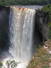
Kaieteur Falls is a high-volume waterfall
on the Potaro River
in central Guyana
, Potaro-Siparuni
region. It is located in
Kaieteur National Park
. It is 226 meters (741 ft) high when measured from its plunge over a sandstone
and conglomerate
cliff to the first break. It then flows over a series of steep cascades that, when included in the measurements, bring the total height to 251 meters (822 ft). While many falls have greater height, few have the combination of height and water volume. This has given Kaieteur Falls the misleading label of "largest single drop" waterfall in the world which is often misinterpreted as "tallest single drop." However, it is likely one of the most powerful waterfalls in the world http://www.world-waterfalls.com/waterfall.php?num=151.
Kaieteur Falls is about five times higher than the more well known Niagara Falls
, located on the border between Canada
and the United States
and about two times the height of the Victoria Falls
located on the border of Zambia
and Zimbabwe
in Africa
. It is a single drop waterfall which is the 123rd tallest (single and multi-drop waterfall) in the world, according to the World Waterfalls Database. The same web site lists it as 19th largest waterfall in terms of volume http://www.world-waterfalls.com/database.php?s=N&t=W&orderby=avevolume&sortLimit=5000, and in their estimation, Kaieteur is the 26th most scenic waterfall in the world http://www.world-waterfalls.com/worldsbest.php?orderby=ratSce%20DESC.
Its distinction lies in the unique combination of great height and large volume, averaging 663 cubic meters per second (23,400 cubic feet per second). Thus it is one of the most powerful waterfalls in the world, rivaling even the Jog Falls
of India
's Karnataka
state during the monsoon
season.
Up river from the falls, the Potaro Plateau stretches out to the distant escarpment
of the Pakaraima Mountains. The Potaro river empties in to the Essequibo River
which is one the longest and widest rivers in South America.
(Guyana), became the first European to see Kaieteur Falls. The other surveyor was James Sawkins. Brown and James Sawkins arrived in Georgetown in 1867 and did some of their mapping and preparation of geological reports together, some in separate expeditions, but Sawkins had taken a break from his work when Brown came upon Kaieteur.
At the time of discovery Brown did not have time to investigate Kaieteur Falls closer and he returned here one year later when measurements of waterfall were made.
Brown’s book Canoe and Camp life in British Guiana was published in 1876. Two years later, in 1878, he published Fifteen Thousand Miles on the Amazon and its tributaries.
According to a Patamona
Indian legend, Kaieteur Falls was named for Kai, a chief, or Toshao who acted to save his people by paddling over the falls in an act of self-sacrifice to Makonaima, the great spirit.
Another legend though was told to Brown by Amerindians in the night of discovery of falls: Kaieteur has been named after an unpleasant old man who was placed in a boat and shoved in the fall by his relatives. Thus the fall was named "Kaieteur" what means - "old-man-fall".
_2007.jpg)

Kaieteur Falls is a major tourist attraction in Guyana. The falls is located in Kaieteur National Park and is in the centre of Guyana's rainforest. There are frequent flights between the falls' airstrip and Ogle Airport
and Cheddi Jagan International Airport
in Georgetown.
is located on the left bank of the Potaro river and is 6 kilometers from Kaieteur falls. The Kaieteur International Airport serves the Potaro-Siparuni
regions.
Waterfall
A waterfall is a place where flowing water rapidly drops in elevation as it flows over a steep region or a cliff.-Formation:Waterfalls are commonly formed when a river is young. At these times the channel is often narrow and deep. When the river courses over resistant bedrock, erosion happens...
on the Potaro River
Potaro River
The Potaro River is a river in Guyana in northern South America.The source of the Potaro River is in the Mount Ayanganna area of the Pakaraima Mountains in the North Rupununi Savannahs...
in central Guyana
Guyana
Guyana , officially the Co-operative Republic of Guyana, previously the colony of British Guiana, is a sovereign state on the northern coast of South America that is culturally part of the Anglophone Caribbean. Guyana was a former colony of the Dutch and of the British...
, Potaro-Siparuni
Potaro-Siparuni
Potaro-Siparuni is a region in Guyana, bordering the region of Cuyuni-Mazaruni to the north, the regions of Upper Demerara-Berbice and East Berbice-Corentyne to the east, the region of Upper Takutu-Upper Essequibo to the south and Brazil to the west.The main towns in the region are Kangaruma,...
region. It is located in
Kaieteur National Park
Kaieteur National Park
Kaieteur National Park is a National Park located in the Potaro-Siparuni Region of Guyana. The Park's boundaries and purpose are defined in the Kaieteur National Park Act, and was created to preserve the natural scenery , and its fauna and flora...
. It is 226 meters (741 ft) high when measured from its plunge over a sandstone
Sandstone
Sandstone is a sedimentary rock composed mainly of sand-sized minerals or rock grains.Most sandstone is composed of quartz and/or feldspar because these are the most common minerals in the Earth's crust. Like sand, sandstone may be any colour, but the most common colours are tan, brown, yellow,...
and conglomerate
Conglomerate (geology)
A conglomerate is a rock consisting of individual clasts within a finer-grained matrix that have become cemented together. Conglomerates are sedimentary rocks consisting of rounded fragments and are thus differentiated from breccias, which consist of angular clasts...
cliff to the first break. It then flows over a series of steep cascades that, when included in the measurements, bring the total height to 251 meters (822 ft). While many falls have greater height, few have the combination of height and water volume. This has given Kaieteur Falls the misleading label of "largest single drop" waterfall in the world which is often misinterpreted as "tallest single drop." However, it is likely one of the most powerful waterfalls in the world http://www.world-waterfalls.com/waterfall.php?num=151.
Kaieteur Falls is about five times higher than the more well known Niagara Falls
Niagara Falls
The Niagara Falls, located on the Niagara River draining Lake Erie into Lake Ontario, is the collective name for the Horseshoe Falls and the adjacent American Falls along with the comparatively small Bridal Veil Falls, which combined form the highest flow rate of any waterfalls in the world and has...
, located on the border between Canada
Canada
Canada is a North American country consisting of ten provinces and three territories. Located in the northern part of the continent, it extends from the Atlantic Ocean in the east to the Pacific Ocean in the west, and northward into the Arctic Ocean...
and the United States
United States
The United States of America is a federal constitutional republic comprising fifty states and a federal district...
and about two times the height of the Victoria Falls
Victoria Falls
The Victoria Falls or Mosi-oa-Tunya is a waterfall located in southern Africa on the Zambezi River between the countries of Zambia and Zimbabwe.-Introduction:...
located on the border of Zambia
Zambia
Zambia , officially the Republic of Zambia, is a landlocked country in Southern Africa. The neighbouring countries are the Democratic Republic of the Congo to the north, Tanzania to the north-east, Malawi to the east, Mozambique, Zimbabwe, Botswana and Namibia to the south, and Angola to the west....
and Zimbabwe
Zimbabwe
Zimbabwe is a landlocked country located in the southern part of the African continent, between the Zambezi and Limpopo rivers. It is bordered by South Africa to the south, Botswana to the southwest, Zambia and a tip of Namibia to the northwest and Mozambique to the east. Zimbabwe has three...
in Africa
Africa
Africa is the world's second largest and second most populous continent, after Asia. At about 30.2 million km² including adjacent islands, it covers 6% of the Earth's total surface area and 20.4% of the total land area...
. It is a single drop waterfall which is the 123rd tallest (single and multi-drop waterfall) in the world, according to the World Waterfalls Database. The same web site lists it as 19th largest waterfall in terms of volume http://www.world-waterfalls.com/database.php?s=N&t=W&orderby=avevolume&sortLimit=5000, and in their estimation, Kaieteur is the 26th most scenic waterfall in the world http://www.world-waterfalls.com/worldsbest.php?orderby=ratSce%20DESC.
Its distinction lies in the unique combination of great height and large volume, averaging 663 cubic meters per second (23,400 cubic feet per second). Thus it is one of the most powerful waterfalls in the world, rivaling even the Jog Falls
Jog Falls
Jog Falls , created by the Sharavathi River falling from a height of is the second-highest plunge waterfall in India Located in Sagara, Karnataka Shimoga District of Karnataka state, these segmented falls are a major tourist attraction...
of India
India
India , officially the Republic of India , is a country in South Asia. It is the seventh-largest country by geographical area, the second-most populous country with over 1.2 billion people, and the most populous democracy in the world...
's Karnataka
Karnataka
Karnataka , the land of the Kannadigas, is a state in South West India. It was created on 1 November 1956, with the passing of the States Reorganisation Act and this day is annually celebrated as Karnataka Rajyotsava...
state during the monsoon
Monsoon
Monsoon is traditionally defined as a seasonal reversing wind accompanied by corresponding changes in precipitation, but is now used to describe seasonal changes in atmospheric circulation and precipitation associated with the asymmetric heating of land and sea...
season.
Up river from the falls, the Potaro Plateau stretches out to the distant escarpment
Escarpment
An escarpment is a steep slope or long cliff that occurs from erosion or faulting and separates two relatively level areas of differing elevations.-Description and variants:...
of the Pakaraima Mountains. The Potaro river empties in to the Essequibo River
Essequibo River
The Esequibo River is the largest river in Guyana, and the largest river between the Orinoco and Amazon. Rising in the Acarai Mountains near the Brazil-Guyana border, the Essequibo flows to the north for 1,010 km through forest and savanna into the Atlantic Ocean.-Geography:There are countless...
which is one the longest and widest rivers in South America.
Discovery by Europeans
On 24 April 1870, Charles Barrington Brown, one of two British geologists appointed government surveyors to the colony of British GuianaBritish Guiana
British Guiana was the name of the British colony on the northern coast of South America, now the independent nation of Guyana.The area was originally settled by the Dutch at the start of the 17th century as the colonies of Essequibo, Demerara, and Berbice...
(Guyana), became the first European to see Kaieteur Falls. The other surveyor was James Sawkins. Brown and James Sawkins arrived in Georgetown in 1867 and did some of their mapping and preparation of geological reports together, some in separate expeditions, but Sawkins had taken a break from his work when Brown came upon Kaieteur.
At the time of discovery Brown did not have time to investigate Kaieteur Falls closer and he returned here one year later when measurements of waterfall were made.
Brown’s book Canoe and Camp life in British Guiana was published in 1876. Two years later, in 1878, he published Fifteen Thousand Miles on the Amazon and its tributaries.
According to a Patamona
Patamona
The Patamona are an Amerindian group, known archaeologically from pottery collections in the Yawong Valley and the upper Siparuni River in the Pakaraima Mountains of Guyana. The upper Siparuni was exploited until recently for suitable farm lands, hunting and fishing...
Indian legend, Kaieteur Falls was named for Kai, a chief, or Toshao who acted to save his people by paddling over the falls in an act of self-sacrifice to Makonaima, the great spirit.
Another legend though was told to Brown by Amerindians in the night of discovery of falls: Kaieteur has been named after an unpleasant old man who was placed in a boat and shoved in the fall by his relatives. Thus the fall was named "Kaieteur" what means - "old-man-fall".
Tourism
Kaieteur Falls is a major tourist attraction in Guyana. The falls is located in Kaieteur National Park and is in the centre of Guyana's rainforest. There are frequent flights between the falls' airstrip and Ogle Airport
Ogle Airport
Ogle Airport is located on the Atlantic Ocean coast of Guyana, 6 miles east of the capital, Georgetown.In 2003 the airport was a local hub shuttling some 50,000 passengers and 1,800 tons of cargo annually. Construction began that year to expand the facility to an international airport with...
and Cheddi Jagan International Airport
Cheddi Jagan International Airport
Cheddi Jagan International Airport , formerly Timehri International Airport, is the national airport of Guyana. The airport is located on the right bank of the Demerara River in the city of Timehri, south of Guyana's capital, Georgetown.-History:...
in Georgetown.
Services
Kaieteur International AirportKaieteur International Airport
Kaietur International Airport is the national airport of the Potaro-Siparuni region and is the second largest gateway to Guyana. It is 6 kilometers from Kaieteur Falls.- Airlines and destinations :- Runways :Kaieteur currently has one runway at 9, 600 ft....
is located on the left bank of the Potaro river and is 6 kilometers from Kaieteur falls. The Kaieteur International Airport serves the Potaro-Siparuni
Potaro-Siparuni
Potaro-Siparuni is a region in Guyana, bordering the region of Cuyuni-Mazaruni to the north, the regions of Upper Demerara-Berbice and East Berbice-Corentyne to the east, the region of Upper Takutu-Upper Essequibo to the south and Brazil to the west.The main towns in the region are Kangaruma,...
regions.
External links
- Kaieteur National Park home to the Kaieteur Falls.
- Geographia.com - Places of interest in Guyana.
- Kaieteur Falls