
South Fork John Day River
Encyclopedia
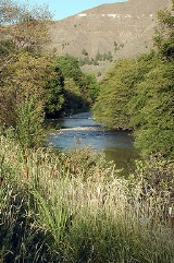
The South Fork John Day River is a 60 miles (96.6 km) tributary of the John Day River
in the U.S. state of Oregon
. It begins in the Malheur National Forest
in Harney County
about 25 miles (40.2 km) north-northwest of Burns
and flows generally north to Dayville
, where it meets the main stem of the John Day River. Along the way, the stream passes through the abandoned town of Izee. Black Canyon Wilderness
in the Ochoco National Forest
lies within the river's drainage basin
.
A total of 47 miles (75.6 km) of the river, from the Malheur National Forest
boundary to Smoky Creek, are classified "recreational" in the National Wild and Scenic River
(NWSR) system and offer opportunities for hiking, swimming, camping, hunting, and fishing.
John Day River
The John Day River is a tributary of the Columbia River, approximately long, in northeastern Oregon in the United States. Undammed along its entire length, the river is the third longest free-flowing river in the conterminous United States. There is extensive use of its waters for irrigation. Its...
in the U.S. state of Oregon
Oregon
Oregon is a state in the Pacific Northwest region of the United States. It is located on the Pacific coast, with Washington to the north, California to the south, Nevada on the southeast and Idaho to the east. The Columbia and Snake rivers delineate much of Oregon's northern and eastern...
. It begins in the Malheur National Forest
Malheur National Forest
The Malheur National Forest is a National Forest in the U.S. state of Oregon. It contains 1.7 million acres in the Blue Mountains of eastern Oregon. The forest include high desert grasslands, sage, juniper, pine, fir, and other tree species. Elevations vary from about 4000 feet to the 9038...
in Harney County
Harney County, Oregon
-National protected areas:*Malheur National Forest *Malheur National Wildlife Refuge*Ochoco National Forest -Demographics:As of the census of 2000, there were 7,609 people, 3,036 households, and 2,094 families residing in the county. The population density was 1 people per square mile...
about 25 miles (40.2 km) north-northwest of Burns
Burns, Oregon
Burns is a city in and the county seat of Harney County, Oregon, United States. As of the 2010 census the population was 2,806.-History:Burns was established in the early 1880s and incorporated upon Harney county's creation in 1889...
and flows generally north to Dayville
Dayville, Oregon
Dayville is a city in Grant County, Oregon, United States. It was incorporated in 1913. The population was 138 at the 2000 census.-Geography:According to the United States Census Bureau, the city has a total area of , all land....
, where it meets the main stem of the John Day River. Along the way, the stream passes through the abandoned town of Izee. Black Canyon Wilderness
Black Canyon Wilderness
The Black Canyon Wilderness of Oregon is a wilderness area in the Ochoco National Forest. It drainage basin of the South Fork of the John Day River. It lies in Grant and Wheeler counties of Oregon. The nearest city is Dayville, in Grant County. It was established in 1984 and encompasses...
in the Ochoco National Forest
Ochoco National Forest
The Ochoco National Forest is located in Central Oregon in the United States, north and east of the City of Prineville, location of the National Forest Headquarters. It encompasses of rimrock, canyons, geologic oddities, dense pine forests, and high desert terrain, as well as the headwaters of...
lies within the river's drainage basin
Drainage basin
A drainage basin is an extent or an area of land where surface water from rain and melting snow or ice converges to a single point, usually the exit of the basin, where the waters join another waterbody, such as a river, lake, reservoir, estuary, wetland, sea, or ocean...
.
A total of 47 miles (75.6 km) of the river, from the Malheur National Forest
Malheur National Forest
The Malheur National Forest is a National Forest in the U.S. state of Oregon. It contains 1.7 million acres in the Blue Mountains of eastern Oregon. The forest include high desert grasslands, sage, juniper, pine, fir, and other tree species. Elevations vary from about 4000 feet to the 9038...
boundary to Smoky Creek, are classified "recreational" in the National Wild and Scenic River
National Wild and Scenic River
National Wild and Scenic River is a designation for certain protected areas in the United States.The National Wild and Scenic Rivers Act was an outgrowth of the recommendations of a Presidential commission, the Outdoor Recreation Resources Review Commission...
(NWSR) system and offer opportunities for hiking, swimming, camping, hunting, and fishing.
See also
- List of rivers of Oregon
- List of longest streams of Oregon
- List of National Wild and Scenic Rivers