
Jefferson Davis Highway
Encyclopedia
The Jefferson Davis Memorial Highway was a planned transcontinental highway in the United States
in the 1910s and 1920s that began in Washington, D.C.
and extended south and west to San Diego, California
; it was named for Jefferson Davis
, who, in addition to being the first and only President of the Confederate States of America
was also a U.S. Congressman and Secretary of War
. Because of unintended conflict between the National Auto Trail
movement and the federal government, it is unclear whether the Jefferson Davis highway ever really existed in the complete form that its founders originally intended.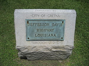
gained in popularity, a system of roads began to develop informally through the actions of private interests, these were known as auto trails. They existed without the support or coordination of the federal government, although in some states, the state governments participated in their planning and development. The first of these National Auto Trails was the Lincoln Highway
, which was first announced as a project in 1912.
With the need for new roads being so significant, dozens of new auto trails were begun in the decade following. One such roadway was the Jefferson Davis Memorial Highway, which was sponsored by the United Daughters of the Confederacy
. The UDC planned the formation of the Jefferson Davis as a road that would start in Washington, D.C.
and travel through the southern states until its terminus at San Diego. More than ten years after the construction of the Jefferson Davis was begun, it was announced that it would be extended north out of San Diego and go the Canadian border.
This problem may well have been the fault of the UDC themselves. In addition to the planned transcontinental route, they also designated an auxiliary route running from Kentucky to Mississippi, as well as another that ran through Georgia. These ancillary routes were intended to commemorate important venues in Davis' life, but they also contributed to the confusion of the federal government in trying to locate exactly where the Jefferson Davis highway traveled. What is known is that when numbered highways came into existence, the Jefferson Davis National Highway was split among U.S. 1, U.S. 15, U.S. 29, U.S. 61, U.S. 80, U.S. 90, U.S. 99, U.S. 190 and others. But today many of these numbered routes themselves are no longer extant, having been supplanted by the Interstate Highway System
.
was removed by city officials. It was subsequently moved twice, and eventually was placed alongside Interstate 5 on private land purchased for the purpose of giving the marker a permanent home.
United States
The United States of America is a federal constitutional republic comprising fifty states and a federal district...
in the 1910s and 1920s that began in Washington, D.C.
Washington, D.C.
Washington, D.C., formally the District of Columbia and commonly referred to as Washington, "the District", or simply D.C., is the capital of the United States. On July 16, 1790, the United States Congress approved the creation of a permanent national capital as permitted by the U.S. Constitution....
and extended south and west to San Diego, California
San Diego, California
San Diego is the eighth-largest city in the United States and second-largest city in California. The city is located on the coast of the Pacific Ocean in Southern California, immediately adjacent to the Mexican border. The birthplace of California, San Diego is known for its mild year-round...
; it was named for Jefferson Davis
Jefferson Davis
Jefferson Finis Davis , also known as Jeff Davis, was an American statesman and leader of the Confederacy during the American Civil War, serving as President for its entire history. He was born in Kentucky to Samuel and Jane Davis...
, who, in addition to being the first and only President of the Confederate States of America
Confederate States of America
The Confederate States of America was a government set up from 1861 to 1865 by 11 Southern slave states of the United States of America that had declared their secession from the U.S...
was also a U.S. Congressman and Secretary of War
United States Secretary of War
The Secretary of War was a member of the United States President's Cabinet, beginning with George Washington's administration. A similar position, called either "Secretary at War" or "Secretary of War," was appointed to serve the Congress of the Confederation under the Articles of Confederation...
. Because of unintended conflict between the National Auto Trail
National auto trail
The system of auto trails was an informal network of marked routes that existed in the United States and Canada in the early part of the 20th century. Marked with colored bands on telephone poles, the trails were intended to help travellers in the early days of the automobile.Auto trails were...
movement and the federal government, it is unclear whether the Jefferson Davis highway ever really existed in the complete form that its founders originally intended.
Background
In the first quarter of the 20th century, as the automobileAutomobile
An automobile, autocar, motor car or car is a wheeled motor vehicle used for transporting passengers, which also carries its own engine or motor...
gained in popularity, a system of roads began to develop informally through the actions of private interests, these were known as auto trails. They existed without the support or coordination of the federal government, although in some states, the state governments participated in their planning and development. The first of these National Auto Trails was the Lincoln Highway
Lincoln Highway
The Lincoln Highway was the first road across the United States of America.Conceived and promoted by entrepreneur Carl G. Fisher, the Lincoln Highway spanned coast-to-coast from Times Square in New York City to Lincoln Park in San Francisco, originally through 13 states: New York, New Jersey,...
, which was first announced as a project in 1912.
With the need for new roads being so significant, dozens of new auto trails were begun in the decade following. One such roadway was the Jefferson Davis Memorial Highway, which was sponsored by the United Daughters of the Confederacy
United Daughters of the Confederacy
The United Daughters of the Confederacy is a women's heritage association dedicated to honoring the memory of those who served in the military and died in service to the Confederate States of America . UDC began as the National Association of the Daughters of the Confederacy, organized in 1894 by...
. The UDC planned the formation of the Jefferson Davis as a road that would start in Washington, D.C.
Washington, D.C.
Washington, D.C., formally the District of Columbia and commonly referred to as Washington, "the District", or simply D.C., is the capital of the United States. On July 16, 1790, the United States Congress approved the creation of a permanent national capital as permitted by the U.S. Constitution....
and travel through the southern states until its terminus at San Diego. More than ten years after the construction of the Jefferson Davis was begun, it was announced that it would be extended north out of San Diego and go the Canadian border.
End of the auto trails
In the mid-1920s, the disparate system of national auto trails had grown cumbersome, and the federal government imposed a numbering system on the nations's highways. Using a system of even numbers for east–west routes and odd numbers for north–south routes, the numbers were imposed on the auto trails. And rather than designate one number for each auto trail, different sections of each trail were given different numerical designations. However the UDC petitioned the U.S. Bureau of Public Roads to designate the Jefferson Davis as a national highway with a single number. The Bureau's reply casts doubt on whether or not the JDMH ever really existed as a transcontinental highway:A careful search has been made in our extensive map file in the Bureau of Public Roads and three maps showing the Jefferson Davis highways have been located, but the routes on these maps are themselves different and neither route is approximately that described by you, so that I am somewhat at a loss as to just what route your constituents are interested in. For instance, there is the Jefferson Davis Memorial Highway which extends from Miami, Florida to Los Angeles (but not to San Francisco); and there is another Jefferson Davis Highway shown on the Rand-McNally maps which extends from Fairview, Kentucky the site of the Jefferson Davis monument, by a very circuitous route to New Orleans, but I find no route whatever bearing the name Jefferson Davis extending from Washington, D.C. to San Francisco. (emphasis added)
This problem may well have been the fault of the UDC themselves. In addition to the planned transcontinental route, they also designated an auxiliary route running from Kentucky to Mississippi, as well as another that ran through Georgia. These ancillary routes were intended to commemorate important venues in Davis' life, but they also contributed to the confusion of the federal government in trying to locate exactly where the Jefferson Davis highway traveled. What is known is that when numbered highways came into existence, the Jefferson Davis National Highway was split among U.S. 1, U.S. 15, U.S. 29, U.S. 61, U.S. 80, U.S. 90, U.S. 99, U.S. 190 and others. But today many of these numbered routes themselves are no longer extant, having been supplanted by the Interstate Highway System
Interstate Highway System
The Dwight D. Eisenhower National System of Interstate and Defense Highways, , is a network of limited-access roads including freeways, highways, and expressways forming part of the National Highway System of the United States of America...
.
Remaining portions of the Jeff Davis
Although it may not be possible to view the entire length of the JDMH on a map today, many parts of it still exist, scattered across the country. Here is an incomplete listing of some of the places today where one can see pieces of the Jefferson Davis highway.California
- The western terminus of the highway is identified by a monument on Horton Plaza, in downtown San Diego. The formal opening of the highway at this terminus was performed by President Warren Harding. Photographs of this event are available in the archives of the SAN DIEGO UNION and in the files of the San Diego Historical Society.
Virginia
- The Virginia General Assembly defined the Jefferson Davis Highway in Virginia on March 17, 1922, as travelling from the District of Columbia at the 14th Street Bridge to the State's border with North CarolinaNorth CarolinaNorth Carolina is a state located in the southeastern United States. The state borders South Carolina and Georgia to the south, Tennessee to the west and Virginia to the north. North Carolina contains 100 counties. Its capital is Raleigh, and its largest city is Charlotte...
south of Clarksville, VirginiaClarksville, VirginiaClarksville is a town founded in Mecklenburg County and overlapping across Halifax County in the U.S. state of Virginia, near the southern border of the state. The population was 1,139 at the 2010 census...
. This corridor was defined as U.S. Route 1U.S. Route 1 in VirginiaU.S. Route 1 in the U.S. state of Virginia runs north–south through South Hill, Petersburg, Richmond, Fredericksburg, and Alexandria on its way from North Carolina to the 14th Street Bridge into the District of Columbia...
and U.S. Route 15U.S. Route 15 in VirginiaU.S. Route 15 is a part of the U.S. Highway System that runs from Walterboro, South Carolina to Painted Post, New York. In Virginia, the U.S. Highway runs from the North Carolina state line near Clarksville north to the Maryland state line at the Potomac River near Lucketts...
in 1926, although US Route 1 took a shorter route between south of McKenneyMcKenney, VirginiaMcKenney is a small southern historic town in Dinwiddie County, Virginia, United States. The population was 483 at the 2010 census.-Geography:McKenney is located at ....
and South HillSouth Hill, VirginiaSouth Hill is a town in Mecklenburg County, Virginia, United States. As of the 2006 census, the town population was 4,608. Located on major Interstate and U.S. highways, it has a full service hospital , a tobacco market, and several hotels. South Hill has a close relationship with the neighboring...
. (The Jefferson Davis Highway used what was then State Route 122Virginia State Route 712 (Brunswick County)State Route 712 is a secondary state highway in Brunswick County, Virginia, United States. It is an old alignment of the road that is now U.S. Route 1, and is still officially part of the Jefferson Davis Highway. SR 712 runs from State Route 606, just south of U.S. Route 58 at Edgerton, north to...
and State Route 12.) Much of U.S. Route 1 in Virginia still bears the name of "Jefferson Davis Highway". - Virginia State Route 110Virginia State Route 110Virginia State Route 110 is a primary state highway in the U.S. state of Virginia. Known as Jefferson Davis Highway, the state highway runs from U.S. Route 1 and Interstate 395 in Crystal City north to I-66 in Rosslyn within Arlington County...
bears the name of "Jefferson Davis Highway" as it travels past The PentagonThe PentagonThe Pentagon is the headquarters of the United States Department of Defense, located in Arlington County, Virginia. As a symbol of the U.S. military, "the Pentagon" is often used metonymically to refer to the Department of Defense rather than the building itself.Designed by the American architect...
in Arlington CountyArlington County, VirginiaArlington County is a county in the Commonwealth of Virginia. The land that became Arlington was originally donated by Virginia to the United States government to form part of the new federal capital district. On February 27, 1801, the United States Congress organized the area as a subdivision of...
between Rosslyn (near the Theodore Roosevelt BridgeTheodore Roosevelt BridgeThe Theodore Roosevelt Bridge is located in Washington, D.C. It carries Interstate 66 and U.S. Highway 50 over the Potomac River near the Kennedy Center, connecting the Rosslyn area of Arlington, Virginia, with Washington...
) and U.S. Route 1 in Crystal City. This is a relatively recent extension to the original Jefferson Davis Highway. The extension was created as part of The Pentagon's road system during World War IIWorld War IIWorld War II, or the Second World War , was a global conflict lasting from 1939 to 1945, involving most of the world's nations—including all of the great powers—eventually forming two opposing military alliances: the Allies and the Axis...
. - The original eastern terminus of the highway can still be found near the Virginia end of the 14th Street Bridge, which crosses the Potomac RiverPotomac RiverThe Potomac River flows into the Chesapeake Bay, located along the mid-Atlantic coast of the United States. The river is approximately long, with a drainage area of about 14,700 square miles...
from Washington, DC. The terminal marker was here until the 1960s, when it was moved to a nearby location for safety reasons. - The northeastern section of the highway approximates the route of the older Washington and Alexandria Turnpike, which received its charter from the United States CongressUnited States CongressThe United States Congress is the bicameral legislature of the federal government of the United States, consisting of the Senate and the House of Representatives. The Congress meets in the United States Capitol in Washington, D.C....
in 1808. A street in Crystal City once designated as "Old Jefferson Davis Highway" parallels the east side of U.S. Route 1, part of which is the present Jefferson Davis Highway in the area. This street, which was the original route of the highway, now ends before reaching the 14th Street Bridge. On September 20, 2011, the Arlington County Board (see Arlington County, Virginia#Government) voted to change the name of the street to "Long Bridge Drive" after the chairman of the Board, who was originally from the northeastern part of the United States, stated: "I have a problem with 'Jefferson Davis' ... There are aspects of our history I'm not particularly interested in celebrating". - Between City of Colonial HeightsColonial Heights, VirginiaColonial Heights is an independent city in Virginia, United States. The population was 17,411 as of 2010. The Bureau of Economic Analysis combines the City of Colonial Heights with Dinwiddie County for statistical purposes...
and City of PetersburgPetersburg, VirginiaPetersburg is an independent city in Virginia, United States located on the Appomattox River and south of the state capital city of Richmond. The city's population was 32,420 as of 2010, predominantly of African-American ethnicity...
, the bridge on the Jefferson Davis Memorial Highway which carries U.S. 1 and U.S. Route 301U.S. Route 301U.S. Route 301 is a spur of U.S. Route 1 running through the South Atlantic States. It currently runs 1,099 miles from Glasgow, Delaware at U.S. Route 40 to Sarasota, Florida. It passes through the states of Delaware, Maryland, Virginia, North Carolina, South Carolina, Georgia, and Florida...
across the Appomattox RiverAppomattox RiverThe Appomattox River is a tributary of the James River, approximately long, in central and eastern Virginia in the United States, named for the Appomattocs Indian tribe who lived along its lower banks in the 17th century...
was renamed Martin Luther King Jr. Memorial BridgeMartin Luther King Jr. Memorial BridgeThe Martin Luther King Jr. Memorial Bridge carries Jefferson Davis Highway across the Appomattox River at the fall line. It joins Colonial Heights and Petersburg, Virginia....
.- State Route 712 and U.S. Route 58U.S. Route 58U.S. Route 58 is an east–west U.S. Highway that runs for from U.S. Route 25E just northwest of Harrogate, Tennessee to U.S. Route 60 in Virginia Beach, Virginia. Until 1996, when the Cumberland Gap Tunnel opened, US 58 ran only inside the commonwealth of Virginia...
are still defined as the Jefferson Davis Highway.
- State Route 712 and U.S. Route 58
- The Jefferson Davis Highway now uses the following business routeBusiness routeA business route in the United States and Canada is a short special route connected to a parent numbered highway at its beginning, then routed through the central business district of a nearby city or town, and finally reconnecting with the same parent numbered highway again at its...
s: - U.S. Route 58 Business in Lawrenceville
- U.S. Route 58 Business in Boydton
- A highway markerBrook Road Marker, Jefferson Davis HighwayThe Brook Road Marker, Jefferson Davis Highway is a commemorative marker on the Jefferson Davis Highway, in Henrico County, Virginia, outside of Richmond, Virginia. The Jefferson Davis Highway was conceived and marked by the United Daughters of the Confederacy, as a counter to the Lincoln Highway...
in Henrico CountyHenrico County, VirginiaHenrico is a county located in the Commonwealth of Virginia, a state of the United States. As of 2010, Henrico was home to 306,935 people. It is located in the Richmond-Petersburg region and is a portion of the Richmond Metropolitan Statistical Area...
is now on the National Register of Historic PlacesNational Register of Historic PlacesThe National Register of Historic Places is the United States government's official list of districts, sites, buildings, structures, and objects deemed worthy of preservation...
.
North Carolina
- The Jefferson Davis Highway traverses through the state for 162 miles (260.7 km). Starting at the VirginiaVirginiaThe Commonwealth of Virginia , is a U.S. state on the Atlantic Coast of the Southern United States. Virginia is nicknamed the "Old Dominion" and sometimes the "Mother of Presidents" after the eight U.S. presidents born there...
state line along US 15 to SanfordSanford, North CarolinaSanford is a city in Lee County, North Carolina, United States. The population was 23,220 at the 2000 census. It is the county seat of Lee County.-Geography:Sanford is located at ....
; then on US 1U.S. Route 1 in North CarolinaU.S. Route 1 is an north–south United States highway that runs for from the South Carolina state line, near Rockingham, to the Virginia state line, near Wise...
from SanfordSanford, North CarolinaSanford is a city in Lee County, North Carolina, United States. The population was 23,220 at the 2000 census. It is the county seat of Lee County.-Geography:Sanford is located at ....
to the South CarolinaSouth CarolinaSouth Carolina is a state in the Deep South of the United States that borders Georgia to the south, North Carolina to the north, and the Atlantic Ocean to the east. Originally part of the Province of Carolina, the Province of South Carolina was one of the 13 colonies that declared independence...
state line. Designation of highway was approved on May 28, 1955.
Georgia
- Highway markers can still be seen in certain spots along the old main transcontinental route through the state of Georgia.
- In the city of CrawfordvilleCrawfordville, GeorgiaCrawfordville is a city in Taliaferro County, Georgia, United States. The population was 572 at the 2000 census. The city is the county seat of Taliaferro County.-Geography:Crawfordville is located at ....
, in Taliaferro CountyTaliaferro County, GeorgiaTaliaferro County is a county located in the U.S. state of Georgia. As of the 2000 census, the population was 2,077, making it the least populous county east of the Mississippi River. The 2007 Census Estimate shows a population of 1,884. The county seat is Crawfordville.The spelling of the...
along U.S. Highway 278 (Georgia State Route 12Georgia State Route 12State Route 12 begins in Avondale Estates, DeKalb County, Georgia at its intersection with SR 10 and ends at SR 10/US 78 in Thomson, Georgia. State Route 12 overlaps U.S. Route 278 its entire length. It is also concurrent with Interstate 20/SR 402 from Exit 75, which is SR 124 in Lithonia until...
). - In Walton CountyWalton County, GeorgiaWalton County is a county located in the U.S. state of Georgia. As of 2009, the population was 87,311. The county seat is Monroe.This county is a part of the Atlanta Metropolitan Area ....
, also along U.S. Highway 278 (Georgia State Route 12Georgia State Route 12State Route 12 begins in Avondale Estates, DeKalb County, Georgia at its intersection with SR 10 and ends at SR 10/US 78 in Thomson, Georgia. State Route 12 overlaps U.S. Route 278 its entire length. It is also concurrent with Interstate 20/SR 402 from Exit 75, which is SR 124 in Lithonia until...
), approximately 810 metres (885.8 yd) from the Morgan CountyMorgan County, GeorgiaMorgan County is a county located in the U.S. state of Georgia. As of 2000, the population was 15,457. The 2005 Census Estimate shows a population of 17,492. The county seat is Madison, Georgia.-Geography:...
line. - An auxiliary route through Georgia went south of the main route through Irwin CountyIrwin County, GeorgiaIrwin County is a county located in the U.S. state of Georgia. It was created on December 15, 1818. As of 2000, the population was 9,931. The 2007 Census Estimate shows a population of 9,934...
and IrwinvilleIrwinville, GeorgiaIrwinville is an unincorporated community in Irwin County, Georgia, United States. It is best known as the site of Jefferson Davis's capture at the end of the Civil War. On May 9, 1865, Jefferson Davis and a small group of officials camped in this pine forest, not knowing that Union cavalry...
, where Davis was ultimately captured at the end of the Civil War. This route followed Georgia State Route 32Georgia State Route 32State Route 32 is a west–east state route located in the southern part of the U.S. state of Georgia. The route travels from SR 520 in Dawson east to SR 99 west of Sterling.-Route description:...
to the west of Irwinville, into neighboring Turner CountyTurner County, GeorgiaTurner County is a county located in the U.S. state of Georgia. It was created on August 18, 1905. As of 2010, the population was 8,930. The county seat is Ashburn.-History:The County is named for Henry Gray Turner, U.S...
, where today S.R. 32 retains the official name of "Jefferson Davis Highway". - In LaGrangeLaGrange, GeorgiaLaGrange is a city in Troup County, Georgia, United States. It is named after the country estate near Paris of the Marquis de La Fayette, who visited the area in 1825. The population was 24,998 at the 2000 census...
, a monument exists at the northeast corner of LaGrange CollegeLaGrange CollegeLaGrange College is the oldest private college in the U.S. state of Georgia. Affiliated with the United Methodist Church, it is located in LaGrange, Georgia, with an enrollment of about 1,000 students. The student-to-faculty ratio is 11:1...
, which is within 1 miles (1.6 km) of Conferate Senator Benjamin Hill's National Historical Home.
Alabama
- In AlabamaAlabamaAlabama is a state located in the southeastern region of the United States. It is bordered by Tennessee to the north, Georgia to the east, Florida and the Gulf of Mexico to the south, and Mississippi to the west. Alabama ranks 30th in total land area and ranks second in the size of its inland...
, the segment of U.S. Highway 80 from SelmaSelma, AlabamaSelma is a city in and the county seat of Dallas County, Alabama, United States, located on the banks of the Alabama River. The population was 20,512 at the 2000 census....
, to MontgomeryMontgomery, AlabamaMontgomery is the capital of the U.S. state of Alabama, and is the county seat of Montgomery County. It is located on the Alabama River southeast of the center of the state, in the Gulf Coastal Plain. As of the 2010 census, Montgomery had a population of 205,764 making it the second-largest city...
is the most famous part of the Jefferson Davis Memorial Highway today. On this road, the Reverend Dr. Martin Luther King, Jr.Martin Luther King, Jr.Martin Luther King, Jr. was an American clergyman, activist, and prominent leader in the African-American Civil Rights Movement. He is best known for being an iconic figure in the advancement of civil rights in the United States and around the world, using nonviolent methods following the...
, led the 1965 Voting Rights March that helped prompt Congress to pass the Voting Rights ActVoting Rights ActThe Voting Rights Act of 1965 is a landmark piece of national legislation in the United States that outlawed discriminatory voting practices that had been responsible for the widespread disenfranchisement of African Americans in the U.S....
. This road also extends through eastern Montgomery and today is known as the Atlanta Highway, although interstate I-85 has replaced the route to Atlanta.
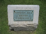
Louisiana
- In LouisianaLouisianaLouisiana is a state located in the southern region of the United States of America. Its capital is Baton Rouge and largest city is New Orleans. Louisiana is the only state in the U.S. with political subdivisions termed parishes, which are local governments equivalent to counties...
, Jefferson Highway goes north out of New Orleans along US 61U.S. Route 61U.S. Route 61 is the official designation for a United States highway that runs from New Orleans, Louisiana, to the city of Wyoming, Minnesota. The highway generally follows the course of the Mississippi River, and is designated the Great River Road for much of its route. As of 2004, the highway's...
and changes onto Louisiana Highway 73Louisiana Highway 73Highway 73 is a highway stretching from Geismar, Louisiana, to Baton Rouge, Louisiana. Hwy. 73 was built as a bypass to the backbends of River Road. It was soon after bypassed itself in a more complete way with U.S...
near Prairieville, LouisianaPrairieville, LouisianaPrairieville is an unincorporated community in Ascension Parish, Louisiana, United States. It is south of Baton Rouge and north of Gonzales, Louisiana. The latitude of is 30.302N. The longitude is -90.971W. Elevation is ....
. It continues along LA-73 into and across Baton Rouge, LouisianaBaton Rouge, LouisianaBaton Rouge is the capital of the U.S. state of Louisiana. It is located in East Baton Rouge Parish and is the second-largest city in the state.Baton Rouge is a major industrial, petrochemical, medical, and research center of the American South...
. - In Baton Rouge, the highway follows Government Street to the leveeLeveeA levee, levée, dike , embankment, floodbank or stopbank is an elongated naturally occurring ridge or artificially constructed fill or wall, which regulates water levels...
and then north along the levee to Florida Street (U.S. 190 Business Route). The road continued west across the Mississippi RiverMississippi RiverThe Mississippi River is the largest river system in North America. Flowing entirely in the United States, this river rises in western Minnesota and meanders slowly southwards for to the Mississippi River Delta at the Gulf of Mexico. With its many tributaries, the Mississippi's watershed drains...
on a now closed ferry into Port Allen, LouisianaPort Allen, LouisianaPort Allen is a city in and the parish seat of West Baton Rouge Parish, Louisiana, United States. Port Allen is located between Interstate 10 and US Highway 190 on the West bank of the Mississippi River. The population was 5,180 at the 2010 census...
. - In Port Allen, Jefferson Highway goes north to the northern end of the town. The highway then follows west along Louisiana Highway 986. The roadway later changes to Louisiana Highway 76Louisiana Highway 76-Route description:LA 76 passes through Iberville and West Baton Rouge Parishes and runs from Louisiana Highway 77 in Maringouin to Louisiana Highway 1 in Port Allen. From the junction with Louisiana Highway 3000 near Ramah to Louisiana Highway 415 near Port Allen High School, the two lane highway...
and follows that highway into the town of Rosedale, LouisianaRosedale, LouisianaRosedale is a village in Iberville Parish, Louisiana, United States. The population was 753 at the 2000 census. It is part of the Baton Rouge Metropolitan Statistical Area.-Geography:Rosedale is located at ....
.It continued up norhtward through the Town of Maringouin, Livonia Fordoche on LA Hwy 77. Then crossed the Atchafalaya River via ferry LA 10 in the City of Melville, LA.
Washington
- Highway 99 all through the State of Washington was Jefferson Davis Highway. The section near the western terminus is now Interstate 5Interstate 5Interstate 5 is the main Interstate Highway on the West Coast of the United States, running largely parallel to the Pacific Ocean coastline from Canada to Mexico . It serves some of the largest cities on the U.S...
. There is a peace arch near the Canadian border, and next to it, was a marker erected by the Daughters of the Confederacy noting that this was a portion of the Jefferson Davis National Highway. The name Jefferson Davis Highway was removed as well as the remaining marker at the northern terminus at Blaine, by action of the Washington State legislature, thereby removing any linkage of Highway 99 to Jefferson Davis. The marker formerly at the Peace Arch Park in Blaine and the marker formerly in Vancouver at the state-line of Washington and Oregon, are now both installed with an interpretive plaque in the Jefferson Davis Park alongside Interstate-5, just south of Ridgefield, Washington.
Controversy
In 1998 a marker of the "Jefferson Davis Memorial Highway" in Vancouver, WashingtonVancouver, Washington
Vancouver is a city on the north bank of the Columbia River in the U.S. state of Washington. Incorporated in 1857, it is the fourth largest city in the state with a 2010 census population of 161,791 as of April 1, 2010...
was removed by city officials. It was subsequently moved twice, and eventually was placed alongside Interstate 5 on private land purchased for the purpose of giving the marker a permanent home.
External links
- US DOT, Federal Highway Administration, official website
- Ends of historic US 99 (includes the Jefferson Davis Highway marker in Washington)
- Jefferson Davis Park (The new home of the Jefferson Davis Highway marker in Washington)