

Virginia State Route 110
Encyclopedia
Virginia State Route 110 (SR 110) is a primary state highway
in the U.S. state of Virginia
. Known as Jefferson Davis Highway, the state highway runs 2.41 miles (3.9 km) from U.S. Route 1
(US 1) and Interstate 395 (I-395) in Crystal City
north to I-66
in Rosslyn
within Arlington County
. SR 110 is a four- to six-lane freeway that parallels the Potomac River
, providing a connection between several of Arlington's urban village
s. The state highway also provides access to the Pentagon
, which is the headquarters of the United States Department of Defense
, the grounds of Arlington National Cemetery
, and SR 27
, an east–west freeway between the Pentagon and the cemetery. SR 110 is a part of the National Highway System
for its entire length.
SR 110 is a part of the Pentagon road network
, a network of freeways and surface roads built concurrent with the construction of the Pentagon in the early 1940s. The state highway received its numerical designation in 1964 when maintenance responsibility was transferred to the Virginia Department of Transportation
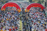
. SR 110's most significant changes in routing were relocation of the highway in Rosslyn to tie into I-66 in the 1980s and relocation of the freeway at the Pentagon to provide a larger security buffer for the building after the September 11 attacks. The highway is sometimes closed for large events held at or around the Pentagon, including the Marine Corps Marathon
.
that allows access from southbound SR 110 to northbound I-395 and US 1 and from southbound I-395 to northbound SR 110. The southbound exit ramp also includes a ramp for Army–Navy Drive, one of the main streets of Pentagon City
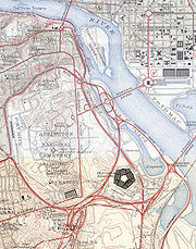
. North of I-395, SR 110 heads north with six lanes immediately to the east of the Pentagon reservation. The southbound freeway has ramps to and from the Pentagon South Parking area, which serves as the main and visitor entrance to the Department of Defense headquarters. SR 110 passes under a pair of pedestrian bridges from Pentagon parking areas on between Boundary Channel Drive, which parallels the freeway, and the Boundary Channel
's Pentagon Lagoon. SR 110 has a southbound exit to and entrance from the Pentagon Mall Terrace and River Terrace areas before the highway leaves the vicinity of the Pentagon by passing under SR 27 (Washington Boulevard). The partial interchange between the highways allows access from eastbound SR 27 to northbound SR 110 and from southbound SR 110 to westbound SR 27, which leads to southbound I-395 and SR 244
(Columbia Pike).
 North of SR 27, the freeway passes between the Washington Metro
's Blue Line on the east and the grounds of Arlington National Cemetery to the west. SR 110 has a northbound exit to and southbound entrance from Memorial Drive, which is the main entrance to the national cemetery and also leads to the Arlington Memorial Bridge
to Washington and the George Washington Memorial Parkway
. SR 110 continues north with four lanes and has its sole at-grade intersection at Marshall Drive, which leads to the Marine Corps War Memorial, also known as the Iwo Jima Memorial, and the Netherlands Carillon
. The highway leaves the cemetery for the urban village of Rosslyn, where the highway reaches its northern terminus. SR 110 passes under US 50
with no access then has a northbound exit and southbound entrance for Wilson Boulevard, one of the main streets of Rosslyn. Immediately to the north, the highway ends at a partial interchange with I-66 allowing access to and from the direction of Falls Church
. Westbound I-66 leads to Dulles International Airport and Front Royal
.
 The road was constructed as a part of the Pentagon Road network during World War II
. Those roads were transferred to the Virginia Department of Highways on December 17, 1964 and assigned the number SR 110. At this time, the north end was reconfigured to accommodate the construction to the Theodore Roosevelt Bridge
in 1964 over the Potomac River and the re-routing of Arlington Ridge Road. As a result, the north end of SR 110 was shifted west toward the prior bridge that carried US 50 over Arlington Ridge Road. SR 110 then proceeded north on the Arlington Ridge Road right-of-way, under the new bridges that carried the approaches to the Roosevelt Bridge reaching Wilson Boulevard. The road extended north to merge with the future I-66 at the Virginia end of the Roosevelt Bridge. Until the 1980s, this extension ended with the exit and entrance ramps to Lee Highway at Lynn Street. However, when I-66 was completed, this stub was extended so that SR 110 had full access to westbound I-66. One block of the historic Arlington Ridge Road was left to act as a frontage road between Wilson Boulevard and 15th Street North.
Following the September 11 attacks, SR 110 was closed to trucks and tour buses due to its proximity to the Pentagon. Police checkpoints were staffed around the clock to enforce this restriction. In September 2002, a contract was awarded to reroute SR 110 to increase the standoff distance between vehicles and the Pentagon. The project, called the Pentagon Secure Bypass, was completed in 2004. SR 110 was shifted eastward in a long arc to maintain a buffer distance from the Pentagon and a two-lane bridge to provide access to the Pentagon North parking lot and two pedestiran bridges were built over the new route. These and related security improvements cost $35 million (equivalent to $ in ) and were completed in October 2004.
State highway
State highway, state road or state route can refer to one of three related concepts, two of them related to a state or provincial government in a country that is divided into states or provinces :#A...
in the U.S. state of Virginia
Virginia
The Commonwealth of Virginia , is a U.S. state on the Atlantic Coast of the Southern United States. Virginia is nicknamed the "Old Dominion" and sometimes the "Mother of Presidents" after the eight U.S. presidents born there...
. Known as Jefferson Davis Highway, the state highway runs 2.41 miles (3.9 km) from U.S. Route 1
U.S. Route 1 in Virginia
U.S. Route 1 in the U.S. state of Virginia runs north–south through South Hill, Petersburg, Richmond, Fredericksburg, and Alexandria on its way from North Carolina to the 14th Street Bridge into the District of Columbia...
(US 1) and Interstate 395 (I-395) in Crystal City
Crystal City, Virginia
Crystal City is an urban neighborhood in the southeastern corner of Arlington County, Virginia, south of downtown Washington, D.C.. Its residents can live, shop, and work without going outside, due to its extensive integration of office buildings and residential high-rise buildings using...
north to I-66
Interstate 66
Interstate 66 is an Interstate Highway in the eastern United States. As indicated by its even route number, it runs in an east–west direction. Its western terminus is at Middletown, Virginia, at an intersection with Interstate 81; its eastern terminus is in Washington, D.C., at an...
in Rosslyn
Rosslyn, Virginia
Rosslyn is an unincorporated area in Northern Virginia located in the northeastern corner of Arlington County, Virginia, north of Arlington National Cemetery and directly across the Potomac River from Georgetown in Washington, D.C. Rosslyn encompasses the Arlington neighborhoods of North Rosslyn...
within Arlington County
Arlington County, Virginia
Arlington County is a county in the Commonwealth of Virginia. The land that became Arlington was originally donated by Virginia to the United States government to form part of the new federal capital district. On February 27, 1801, the United States Congress organized the area as a subdivision of...
. SR 110 is a four- to six-lane freeway that parallels the Potomac River
Potomac River
The Potomac River flows into the Chesapeake Bay, located along the mid-Atlantic coast of the United States. The river is approximately long, with a drainage area of about 14,700 square miles...
, providing a connection between several of Arlington's urban village
Urban village
An urban village is an urban planning and urban design concept. It refers to an urban form typically characterized by:* Medium density development* Mixed use zoning* The provision of good public transit...
s. The state highway also provides access to the Pentagon
The Pentagon
The Pentagon is the headquarters of the United States Department of Defense, located in Arlington County, Virginia. As a symbol of the U.S. military, "the Pentagon" is often used metonymically to refer to the Department of Defense rather than the building itself.Designed by the American architect...
, which is the headquarters of the United States Department of Defense
United States Department of Defense
The United States Department of Defense is the U.S...
, the grounds of Arlington National Cemetery
Arlington National Cemetery
Arlington National Cemetery in Arlington County, Virginia, is a military cemetery in the United States of America, established during the American Civil War on the grounds of Arlington House, formerly the estate of the family of Confederate general Robert E. Lee's wife Mary Anna Lee, a great...
, and SR 27
Virginia State Route 27
State Route 27 is a freeway in Arlington County, Virginia, in the United States. It was built during World War II to connect the Pentagon with U.S. Route 50 and northern Arlington to the west and Washington, DC, to the east. Its route parallels the southern boundaries of Arlington National...
, an east–west freeway between the Pentagon and the cemetery. SR 110 is a part of the National Highway System
National Highway System (United States)
The National Highway System is a network of strategic highways within the United States, including the Interstate Highway System and other roads serving major airports, ports, rail or truck terminals, railway stations, pipeline terminals and other strategic transport facilities.Individual states...
for its entire length.
SR 110 is a part of the Pentagon road network
Pentagon road network
The Pentagon road network is a system of highways, mostly freeways, built by the United States federal government in the early 1940s to serve the Pentagon in northern Virginia. The roads, transferred to the Commonwealth of Virginia in 1964, are now state highways...
, a network of freeways and surface roads built concurrent with the construction of the Pentagon in the early 1940s. The state highway received its numerical designation in 1964 when maintenance responsibility was transferred to the Virginia Department of Transportation
Virginia Department of Transportation
The Virginia Department of Transportation is the agency of state government responsible for transportation in the state of Virginia in the United States. Headquartered in Downtown Richmond, VDOT is responsible for building, maintaining, and operating the roads, bridges and tunnels in the...
. SR 110's most significant changes in routing were relocation of the highway in Rosslyn to tie into I-66 in the 1980s and relocation of the freeway at the Pentagon to provide a larger security buffer for the building after the September 11 attacks. The highway is sometimes closed for large events held at or around the Pentagon, including the Marine Corps Marathon
Marine Corps Marathon
The Marine Corps Marathon is an annual marathon held in Arlington, Virginia and Washington, DC. The mission of the MCM is to promote physical fitness, generate community goodwill and showcase the organizational skills of the United States Marine Corps....
.
Route description
SR 110 begins at a partial interchange with US 1 (Jefferson Davis Highway) in Crystal City where US 1 joins I-395 to cross the 14th Street Bridge into Washington; the interchange allows access to and from US 1 in the direction of Alexandria. Immediately to the north, the state highway has a partial interchange with I-395 (Henry G. Shirley Memorial HighwayHenry G. Shirley Memorial Highway
The Henry G. Shirley Memorial Highway consists of a portion of Interstates 95 and 395 in the U.S. state of Virginia. Shirley Highway was the first limited-access freeway in Virginia...
that allows access from southbound SR 110 to northbound I-395 and US 1 and from southbound I-395 to northbound SR 110. The southbound exit ramp also includes a ramp for Army–Navy Drive, one of the main streets of Pentagon City
Pentagon City, Virginia
Pentagon City is an unincorporated neighborhood located in the southeast portion of Arlington County, Virginia, near The Pentagon and Arlington National Cemetery...
. North of I-395, SR 110 heads north with six lanes immediately to the east of the Pentagon reservation. The southbound freeway has ramps to and from the Pentagon South Parking area, which serves as the main and visitor entrance to the Department of Defense headquarters. SR 110 passes under a pair of pedestrian bridges from Pentagon parking areas on between Boundary Channel Drive, which parallels the freeway, and the Boundary Channel
Boundary Channel
Boundary Channel is a channel off the Potomac River in Washington, D.C. The channel extends southward from the Potomac between Columbia Island to the east and the Virginia shore to the west and ends at the Pentagon Lagoon. Boundary Channel is shallow and is crossed by several fixed...
's Pentagon Lagoon. SR 110 has a southbound exit to and entrance from the Pentagon Mall Terrace and River Terrace areas before the highway leaves the vicinity of the Pentagon by passing under SR 27 (Washington Boulevard). The partial interchange between the highways allows access from eastbound SR 27 to northbound SR 110 and from southbound SR 110 to westbound SR 27, which leads to southbound I-395 and SR 244
Virginia State Route 244
State Route 244, also known as Columbia Pike, is a primary state highway in the U.S. state of Virginia. It is a four-lane road that runs from State Route 236 in Annandale, Fairfax County east to State Route 27 at the Pentagon in Arlington County.-History:Columbia Pike dates to 1810 when the U.S...
(Columbia Pike).
Washington Metro
The Washington Metro, commonly called Metro, and unofficially Metrorail, is the rapid transit system in Washington, D.C., United States, and its surrounding suburbs. It is administered by the Washington Metropolitan Area Transit Authority , which also operates Metrobus service under the Metro name...
's Blue Line on the east and the grounds of Arlington National Cemetery to the west. SR 110 has a northbound exit to and southbound entrance from Memorial Drive, which is the main entrance to the national cemetery and also leads to the Arlington Memorial Bridge
Arlington Memorial Bridge
The Arlington Memorial Bridge in Washington, D.C. crosses the Potomac River, connecting the Lincoln Memorial and Columbia Island. The northeastern end of the bridge marks the western edge of the National Mall...
to Washington and the George Washington Memorial Parkway
George Washington Memorial Parkway
The George Washington Memorial Parkway, known to local motorists simply as the "G.W. Parkway", is a parkway maintained by the U.S. National Park Service. It is located mostly in Northern Virginia, although a short section northwest of the Arlington Memorial Bridge passes over Columbia Island,...
. SR 110 continues north with four lanes and has its sole at-grade intersection at Marshall Drive, which leads to the Marine Corps War Memorial, also known as the Iwo Jima Memorial, and the Netherlands Carillon
Netherlands Carillon
The Netherlands Carillon adjacent to Arlington National Cemetery was a gift from the people of the Netherlands to the people of the United States of America in 1954. The gift was made to thank the United States for its aid during and after World War II. First installed at a nearby site in 1954,...
. The highway leaves the cemetery for the urban village of Rosslyn, where the highway reaches its northern terminus. SR 110 passes under US 50
U.S. Route 50 in Virginia
U.S. Route 50 is a transcontinental highway which stretches from Ocean City, Maryland to Sacramento, California. In the U.S. state of Virginia, US 50 extends from the border with Washington DC at a Potomac River crossing at Rosslyn in Arlington County to the West Virginia state line near Gore in...
with no access then has a northbound exit and southbound entrance for Wilson Boulevard, one of the main streets of Rosslyn. Immediately to the north, the highway ends at a partial interchange with I-66 allowing access to and from the direction of Falls Church
Falls Church, Virginia
The City of Falls Church is an independent city in Virginia, United States, in the Washington Metropolitan Area. The city population was 12,332 in 2010, up from 10,377 in 2000. Taking its name from The Falls Church, an 18th-century Anglican parish, Falls Church gained township status within...
. Westbound I-66 leads to Dulles International Airport and Front Royal
Front Royal, Virginia
Front Royal is a town in Warren County, Virginia, United States. The population was 13,589 at the 2000 census. It is the county seat of Warren County.-Geography:Front Royal is roughly west of Washington, D.C....
.
History
World War II
World War II, or the Second World War , was a global conflict lasting from 1939 to 1945, involving most of the world's nations—including all of the great powers—eventually forming two opposing military alliances: the Allies and the Axis...
. Those roads were transferred to the Virginia Department of Highways on December 17, 1964 and assigned the number SR 110. At this time, the north end was reconfigured to accommodate the construction to the Theodore Roosevelt Bridge
Theodore Roosevelt Bridge
The Theodore Roosevelt Bridge is located in Washington, D.C. It carries Interstate 66 and U.S. Highway 50 over the Potomac River near the Kennedy Center, connecting the Rosslyn area of Arlington, Virginia, with Washington...
in 1964 over the Potomac River and the re-routing of Arlington Ridge Road. As a result, the north end of SR 110 was shifted west toward the prior bridge that carried US 50 over Arlington Ridge Road. SR 110 then proceeded north on the Arlington Ridge Road right-of-way, under the new bridges that carried the approaches to the Roosevelt Bridge reaching Wilson Boulevard. The road extended north to merge with the future I-66 at the Virginia end of the Roosevelt Bridge. Until the 1980s, this extension ended with the exit and entrance ramps to Lee Highway at Lynn Street. However, when I-66 was completed, this stub was extended so that SR 110 had full access to westbound I-66. One block of the historic Arlington Ridge Road was left to act as a frontage road between Wilson Boulevard and 15th Street North.
Following the September 11 attacks, SR 110 was closed to trucks and tour buses due to its proximity to the Pentagon. Police checkpoints were staffed around the clock to enforce this restriction. In September 2002, a contract was awarded to reroute SR 110 to increase the standoff distance between vehicles and the Pentagon. The project, called the Pentagon Secure Bypass, was completed in 2004. SR 110 was shifted eastward in a long arc to maintain a buffer distance from the Pentagon and a two-lane bridge to provide access to the Pentagon North parking lot and two pedestiran bridges were built over the new route. These and related security improvements cost $35 million (equivalent to $ in ) and were completed in October 2004.