
Jaigaon
Encyclopedia
Jaigaon is a small town in Jalpaiguri district
in the India
n state
of West Bengal
, near the Bhutan
border. The town lies at the gateway to Bhutan - Phuentsholing, and is thus a very thriving place of trade. The main source of income for the vast majority of people here is through the Bhutanese citizens, that come down to Jaigaon in order to buy their monthly and weekly ration.
The main entrance to Bhutan is through Jaigaon. As Bhutan is a Himalayan Kingdom, it does not have roads linking to all its towns. Thus, Bhutan uses Indian roads to reach some of its cities, namely Shamtshe, Gomtu and Samdrup Dzonkhang. Bagdogra (Siliguri) is the nearest airport, and Kolkata its nearest port, where goods to Bhutan are brought to. India offers a free flow of goods from Kolkata port to Bhutan.
It lies on the banks of the Torsa
river. It is a census town
and a police station of Alipurduar
subdivision
However, with the younger generations taking over from their preceding generations, there are brightened hopes of a holistic development in the part of the world. We can expect to see more schools, hopsitals and other basic infrastructure coming up in the near future.
Jaigaon is part of the proposed and there are agitations going on every now and then. Although, in this part of the proposed Gorkhaland, the agitation is not very strong as the population consists of various communities. The population consists mainly of Bengali, Nepali (gorkhali),Bihari,Marwadi communities and the tribals of that place.
However, with the younger generations taking over from their preceding generations, there are brightened hopes of a holistic development in the part of the world. We can expect to see more schools, hopsitals and other basic infrastructure coming up in the near future.
, Jaygaon had a population of 1,58,664. Males constitute 52% of the population and females 48%. Jaygaon has an average literacy rate of 90%, much higher than the national average of 59.5%: male literacy is 90%, and female literacy is 90%. In Jaygaon, 16% of the population is under 6 years of age.
Jalpaiguri District
Jalpaiguri district is the largest district of North Bengal, covering an area 6,245 km2. It is situated between 26° 16' and 27° 0' North latitudes and 88° 4' and 89° 53' East longitudes...
in the India
India
India , officially the Republic of India , is a country in South Asia. It is the seventh-largest country by geographical area, the second-most populous country with over 1.2 billion people, and the most populous democracy in the world...
n state
States and territories of India
India is a federal union of states comprising twenty-eight states and seven union territories. The states and territories are further subdivided into districts and so on.-List of states and territories:...
of West Bengal
West Bengal
West Bengal is a state in the eastern region of India and is the nation's fourth-most populous. It is also the seventh-most populous sub-national entity in the world, with over 91 million inhabitants. A major agricultural producer, West Bengal is the sixth-largest contributor to India's GDP...
, near the Bhutan
Bhutan
Bhutan , officially the Kingdom of Bhutan, is a landlocked state in South Asia, located at the eastern end of the Himalayas and bordered to the south, east and west by the Republic of India and to the north by the People's Republic of China...
border. The town lies at the gateway to Bhutan - Phuentsholing, and is thus a very thriving place of trade. The main source of income for the vast majority of people here is through the Bhutanese citizens, that come down to Jaigaon in order to buy their monthly and weekly ration.
The main entrance to Bhutan is through Jaigaon. As Bhutan is a Himalayan Kingdom, it does not have roads linking to all its towns. Thus, Bhutan uses Indian roads to reach some of its cities, namely Shamtshe, Gomtu and Samdrup Dzonkhang. Bagdogra (Siliguri) is the nearest airport, and Kolkata its nearest port, where goods to Bhutan are brought to. India offers a free flow of goods from Kolkata port to Bhutan.
It lies on the banks of the Torsa
Torsa
Torsa is one of the Slate Islands in Argyll and Bute, Scotland.Lying east of Luing and south of Seil, the island was inhabited until the 1960s. There is now only one house on the island, which is used for holiday lets. Its main industry is farming, with cattle brought over from the neighbouring...
river. It is a census town
Census town
In India, a census town is one which has:# A minimum population of 5,000# At least 75% of male working population engaged in non-agricultural pursuits# A density of population of at least 400 persons per km2.In Ireland, a census town is;...
and a police station of Alipurduar
Alipurduar
Alipurduar is a sub-divisional municipal city of Jalpaiguri district, and is located at the eastern end of the district. Situated on the east bank of Kaljani River on the foothills of the Himalayas, the town is a gateway to Bhutan and North Eastern states of India...
subdivision
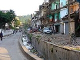
Environment
While Jaigaon used to have a clean environment earlier, it is now very polluted with dust and air pollution. The Bengal government is reluctant to build roads in this area. The roads have been improved a lot since November 2009. Also, it lacks one very basic amenity- public hospital in spite of having a huge population a prosperous economy. The residents of Jaigaon do not seem to pay attention to this matter not realizing the adverse effects such as high medical expenses which they incur from time to time. Also, the waste disposal system of jaigaon is very poor. But it seems like the people hardly care. 'Businessmen' residing in Jaigaon have hardly taken any initiative.However, with the younger generations taking over from their preceding generations, there are brightened hopes of a holistic development in the part of the world. We can expect to see more schools, hopsitals and other basic infrastructure coming up in the near future.
Jaigaon is part of the proposed and there are agitations going on every now and then. Although, in this part of the proposed Gorkhaland, the agitation is not very strong as the population consists of various communities. The population consists mainly of Bengali, Nepali (gorkhali),Bihari,Marwadi communities and the tribals of that place.
Geography
Jaigaon is located at 26.83°N 89.38°E.However, with the younger generations taking over from their preceding generations, there are brightened hopes of a holistic development in the part of the world. We can expect to see more schools, hopsitals and other basic infrastructure coming up in the near future.
Demographics
India censusCensus
A census is the procedure of systematically acquiring and recording information about the members of a given population. It is a regularly occurring and official count of a particular population. The term is used mostly in connection with national population and housing censuses; other common...
, Jaygaon had a population of 1,58,664. Males constitute 52% of the population and females 48%. Jaygaon has an average literacy rate of 90%, much higher than the national average of 59.5%: male literacy is 90%, and female literacy is 90%. In Jaygaon, 16% of the population is under 6 years of age.