
Israel National Trail
Encyclopedia
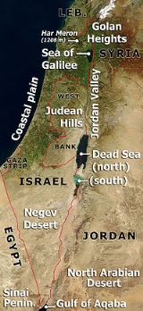
The Israel National Trail, is a hiking path that crosses the entire country of Israel
. Its northern end is at Dan, near the Lebanese border in the far north of the country, and it extends to Eilat at the southernmost tip of Israel on the Red Sea
, a length of approximately 940 km (580 mi). The trail is marked with three stripes (white, blue, and orange), and takes an average of 45 days to complete.
Because the southern section of the trail passes through many isolated areas, hikers cache supplies of food and water at designated points on the trail before beginning the hike or pay for supplies to be delivered.
The trail does not enter the Israeli-occupied territories
of the Golan Heights and the West Bank
.
, Ezer Weizmann in 1994. One of its purposes is to give Israelis a way to experience the entire breadth of the land firsthand. The various sections of the trail have been added progressively during this development.
In 2003 a portion of the trail was diverted from the Sharon and now runs along the coast. The reasons for the change were the development of Highway 6
, avoiding the security risk of walking along the Green Line
and the desire to add to the trail sections with city and sea views.
According to statistics compiled in 2010, only 4 out of 10 hikers complete the entire trail. Recognizing this, the planners divided it into smaller sections that can be hiked separately. Some sections can be completed in day trips or over the weekend.
Hikers can seek help from “trail angels” who offer “lawns to sleep on,” “a room with a shower” or “a pickup from the trail.” For example, at Kibbutz
Yagur
, a soldier leaves the key to her room for hikers who need a place to sleep and a farmer in Hadera
forest offers sleeping quarters in exchange for a day’s work.
 Naftali Ridge and Ramim Cliffs (Upper Galilee
) - On the eastern slopes of the Ramim Cliffs (Matzoc Ramim) are several dirt roads and walking routes, springs and observation points overlooking the Hula Valley
. The Israel National Trail is marked here by afforestation roads and views of planted forests and natural undergrowth. The area ranges from a deserted sandstone quarry above Kiryat Shmona
, at the height of 280m above sea level, southward towards Yesha Fortress
(Metzudat Yesha). In the autumn, the trail is rich with rain forecasting flowers, especially types of crocus and early blossoming cyclamens.
Kadesh Ili stream and Yesha fortress (Upper Galilee) - The bottom of the canyon is hard limestone
, and the path lies in the shadow of the treetop canopy. (Note: The lower part of Kadesh Stream (Nakhal Kadesh) is for fit walkers only.) Elsewhere along the Kadesh Stream, hikers can climb rock steps up the stream's southern bank to view the ravine from above. The trail continues to Yesha Fortress
, to the burial structure of Nebi Yusha and on to the exit point.
Meron
stream's parking lot to Ein Zeved and Shema ruins (Upper Galilee) - A circular trail on the eastern slopes of Mount Meron
. The trail climbs upwards from the parking lot through Meron Stream and Meron Ili Stream, Ein Zeved, "Elijah's Chair" (Kisse Eliyahu, a tall rock shaped like a pillar), the Shema ruins and back to the parking lot. Part of the trail has regular trail marks and the walk down through Elijah's Chair has Israel National Trail marks only. During spring you can see a variety of rich blossoms including orchids. Towards summer, different flowers appear and color the area yellow. The raspberry fruit ripens at the end of the summer.
Mount Tabor
(Lower Galilee) - As it says in the book of Jeremiah, "as Tavor among mountains", the presence of Mount Tabor is highly visible. The trail takes hikers up the Tabor and around the monasteries on its peak, near the remains of ancient walls, corner towers, caves, exposed antiquities, spring blossoms and of course, views to any direction from the sides of the mountain. The "mountain surrounding" road at half-altitude (around 250-350M above sea level) created by the Jewish National Fund provides an impressive view.
Tzippori
stream (Lower Galilee) - The trail here covers one of the geographical areas least familiar to many travelers. In this area of gall oaks (known in Hebrew as "Alon HaTavor" - Tabor oak), also features birch
trees and carpets of blossom in winter and spring. Along the trail are streams of flowing water, improvised water pumps and a castle named "The Monks Mill" (Takhanat HaNezirim) and the remains of another impressive gristmill at the Alil ruins (Khurbat Alil).
Ma'apilim/Nakhash stream (Carmel
) - A walk through Nakhash Stream provides an almost complete representation of the Carmel's hidden treasures: From the top of the trail and while walking down the ravine, you can see an impressive view of the Northern Coastal Plain
and the Galilee. The path exits near Kibbutz
Yagur
. You can also see a vertical karstic hole, the "Arbutus Curve" (Icul HaCatlavim) and at the end of the trail, the Haganah
slik (hiding place for weaponry) in Yagur. "Nakhash" means "snake" in Hebrew. The name is derived from the Arabic "Wadi al Hia". Nowadays, the stream is called "Nakhal Ma'apilim" after the illegal Jewish immigrants who secretly arrived at the Mediterranean shore during the time of the British mandate.
After this part, the Israel National Trail continues through the Sharon plain, Gush Dan
, and Shephelah
areas, which are not mentioned among the 12 sections.
Shayarot Range (Judean Mountains
) - A trip to the Shayarot Range (Shlukhat Shayarot) provides views down to the Coastal Plain
and up to the Judean Mountains
, hundreds of kilometers of mountain dirt tracks, walking routes, caves, and an abundance of flowers in the spring. The trail passes through the "Burma Road", or "Sheva Road". Here you can climb to the military posts overlooking Highway 1
, the Jerusalem-Tel Aviv road, used by Palmach
soldiers of the Har'el division in their battles on the road to Jerusalem during the Israeli War of Independence
. From here the route have a two days site trip to Jerusalem via the Jerusalem Trail
.
Yatir ruins to Dragot Quarry - This segment of the Israel National Trail goes from the Yatir ruins (Khurbat Yatir), one of the Levi
cities in the land of Judea
on the eastern brim of the Yatir Mountains ridge, through the Yatir Forest
, the largest forest planted by the Jewish National Fund
, to the Mount Amsha (Har Amasa
) nature reserve, which has impressive views and unique plants. It also contains the remains of the Roman "freeway" Ma'ale Dragot.
Mamshit
and Mamshit stream (Negev
) - The trail passes through the ancient city of Mamshit, its alleys, churches, remains of stables, houses and administrative structures. You can visit the ancient dams at Mamshit Stream's (Nakhal Mamshit) river bed, walk through the narrow canyon of the stream and see the remains of ancient agriculture. The path exits to road 206, at the Rotem - Oron intersection.
Mitzpe Ramon
and Ramon Crater (Negev
) - The town of Mitzpe Ramon is a meeting place for artists, a station for people going down south to Eilat, and a base for visitors to the Ramon Crater (Makhtesh Ramon). Ibex roam free on the cliffs, and the colors of the crater change at different times of the day.
Kisuy stream and Ovda Valley (Negev
) - Near Ovda Valley (Bik'at Ovda) are dunes of sand like on the beach or in the Sinai. Ancient remains include temples, ritual locations and interesting structures near the sides of the roads. From the modern settlement of Shakharot, there are views to the Arava
desert.
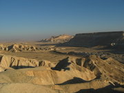
Shkhoret stream (Eilat Mountains) - On the route are sandstone
geological formations such as the "Amir formation" and "Shkhoret formation". You can see element rocks, sorts of granites in streams (or wadis) that undermined in their predecessors' sediment walls, desert plants and perhaps even representatives of the local fauna. Different shades of sandstones, the granite and its shapes and dark colors, plaster ornaments on the rock and colors galore, all of it there in Eilat area.
Israel
The State of Israel is a parliamentary republic located in the Middle East, along the eastern shore of the Mediterranean Sea...
. Its northern end is at Dan, near the Lebanese border in the far north of the country, and it extends to Eilat at the southernmost tip of Israel on the Red Sea
Red Sea
The Red Sea is a seawater inlet of the Indian Ocean, lying between Africa and Asia. The connection to the ocean is in the south through the Bab el Mandeb strait and the Gulf of Aden. In the north, there is the Sinai Peninsula, the Gulf of Aqaba, and the Gulf of Suez...
, a length of approximately 940 km (580 mi). The trail is marked with three stripes (white, blue, and orange), and takes an average of 45 days to complete.
Because the southern section of the trail passes through many isolated areas, hikers cache supplies of food and water at designated points on the trail before beginning the hike or pay for supplies to be delivered.
The trail does not enter the Israeli-occupied territories
Israeli-occupied territories
The Israeli-occupied territories are the territories which have been designated as occupied territory by the United Nations and other international organizations, governments and others to refer to the territory seized by Israel during the Six-Day War of 1967 from Egypt, Jordan, and Syria...
of the Golan Heights and the West Bank
West Bank
The West Bank ) of the Jordan River is the landlocked geographical eastern part of the Palestinian territories located in Western Asia. To the west, north, and south, the West Bank shares borders with the state of Israel. To the east, across the Jordan River, lies the Hashemite Kingdom of Jordan...
.
History
The Israel National Trail was officially inaugurated by then President of IsraelPresident of Israel
The President of the State of Israel is the head of state of Israel. The position is largely an apolitical ceremonial figurehead role, with the real executive power lying in the hands of the Prime Minister. The current president is Shimon Peres who took office on 15 July 2007...
, Ezer Weizmann in 1994. One of its purposes is to give Israelis a way to experience the entire breadth of the land firsthand. The various sections of the trail have been added progressively during this development.
In 2003 a portion of the trail was diverted from the Sharon and now runs along the coast. The reasons for the change were the development of Highway 6
Highway 6 (Israel)
Highway 6 , widely known as the Trans-Israel Highway or Cross-Israel Highway , is a major electronic toll highway in Israel. The highway was officially dedicated as the Yitzhak Rabin Highway , though this name is not commonly used. It started operating in the early 2000s and is being lengthened as...
, avoiding the security risk of walking along the Green Line
Green Line (Israel)
Green Line refers to the demarcation lines set out in the 1949 Armistice Agreements between Israel and its neighbours after the 1948 Arab-Israeli War...
and the desire to add to the trail sections with city and sea views.
According to statistics compiled in 2010, only 4 out of 10 hikers complete the entire trail. Recognizing this, the planners divided it into smaller sections that can be hiked separately. Some sections can be completed in day trips or over the weekend.
Hikers can seek help from “trail angels” who offer “lawns to sleep on,” “a room with a shower” or “a pickup from the trail.” For example, at Kibbutz
Kibbutz
A kibbutz is a collective community in Israel that was traditionally based on agriculture. Today, farming has been partly supplanted by other economic branches, including industrial plants and high-tech enterprises. Kibbutzim began as utopian communities, a combination of socialism and Zionism...
Yagur
Yagur
Yagur is a kibbutz in northern Israel. Located on the slopes of Mount Carmel about 9 km southeast of Haifa, it is one of the two largest kibbutzim in the country, with a population of 1,124 in 2008. It falls under the jurisdiction of Zevulun Regional Council....
, a soldier leaves the key to her room for hikers who need a place to sleep and a farmer in Hadera
Hadera
Hadera is a city located in the Haifa District of Israel approximately from the major cities of Tel Aviv and Haifa. The city is located along of the Israeli Mediterranean Coastal Plain...
forest offers sleeping quarters in exchange for a day’s work.
Sections
The Israel National Trail includes 11 sections:- Naftali Ridge and Ramim Cliffs (Upper GalileeGalileeGalilee , is a large region in northern Israel which overlaps with much of the administrative North District of the country. Traditionally divided into Upper Galilee , Lower Galilee , and Western Galilee , extending from Dan to the north, at the base of Mount Hermon, along Mount Lebanon to the...
) - Kadesh Naftali stream and Yesha fortressMetzudat KoachThe Metzudat Koach Memorial commemorates 28 soldiers who died during the 1948 conquest of a strategically important fort. The fort and observation point is located in the Upper Galilee, close to the tomb of Nabi Yusha...
(Upper Galilee) - MeronMeron (Israel)Meron is a moshav on the slopes of Mount Meron, in the Upper Galilee in northern Israel near Safed, and within municipal jurisdiction of the Merom HaGalil Regional Council...
stream's parking lot to Ein Zeved and Shema ruins (Upper Galilee) - Mount TaborMount Tabor-Places:*Mount Tabor, a hill in Israel near Nazareth believed by many to be the site of the Transfiguration of ChristIn the United States:*Mount Tabor, Indiana, an unincorporated community...
(Lower Galilee) - TzipporiTzipporiTzippori , also known as Sepphoris, Dioceserea and Saffuriya is located in the central Galilee region, north-northwest of Nazareth, in modern-day Israel...
stream (Lower Galilee) - Ma'apilim / Nakhash stream (Mount CarmelMount CarmelMount Carmel ; , Kármēlos; , Kurmul or جبل مار إلياس Jabal Mar Elyas 'Mount Saint Elias') is a coastal mountain range in northern Israel stretching from the Mediterranean Sea towards the southeast. Archaeologists have discovered ancient wine and oil presses at various locations on Mt. Carmel...
) - Shayarot Range (Judean Mountains)
- Yatir ruins to Dragot Quarry
- Mitzpe RamonMitzpe RamonMitzpe Ramon is a town in the Negev desert of southern Israel. It is situated on the northern ridge at an elevation of 860 meters overlooking a sizable erosion cirque known as the Ramon Crater.-History:...
and Ramon Crater (Negev) - Kisuy stream and OvdaOvdaOvda or Uvda may refer to:*Ovda **Operation Uvda**Ovda Israeli Air Force Base**Ovda International Airport*Ovda Regio on Venus...
Valley (Negev) - Shkhoret stream (Eilat Mountains)
Galilee
Galilee , is a large region in northern Israel which overlaps with much of the administrative North District of the country. Traditionally divided into Upper Galilee , Lower Galilee , and Western Galilee , extending from Dan to the north, at the base of Mount Hermon, along Mount Lebanon to the...
) - On the eastern slopes of the Ramim Cliffs (Matzoc Ramim) are several dirt roads and walking routes, springs and observation points overlooking the Hula Valley
Hulah Valley
The Hula Valley is an agricultural region in northern Israel with abundant fresh water. It is a major stopover for birds migrating along the Syrian-African Rift Valley between Africa, Europe, and Asia. The marshland around Lake Hula, a breeding grounds for malaria, was drained in the 1950s...
. The Israel National Trail is marked here by afforestation roads and views of planted forests and natural undergrowth. The area ranges from a deserted sandstone quarry above Kiryat Shmona
Kiryat Shmona
Kiryat Shmona is a city located in the North District of Israel on the western slopes of the Hula Valley on the Lebanese border. The city was named for the eight people, including Joseph Trumpeldor, who died in 1920 defending Tel Hai....
, at the height of 280m above sea level, southward towards Yesha Fortress
Metzudat Koach
The Metzudat Koach Memorial commemorates 28 soldiers who died during the 1948 conquest of a strategically important fort. The fort and observation point is located in the Upper Galilee, close to the tomb of Nabi Yusha...
(Metzudat Yesha). In the autumn, the trail is rich with rain forecasting flowers, especially types of crocus and early blossoming cyclamens.
Kadesh Ili stream and Yesha fortress (Upper Galilee) - The bottom of the canyon is hard limestone
Limestone
Limestone is a sedimentary rock composed largely of the minerals calcite and aragonite, which are different crystal forms of calcium carbonate . Many limestones are composed from skeletal fragments of marine organisms such as coral or foraminifera....
, and the path lies in the shadow of the treetop canopy. (Note: The lower part of Kadesh Stream (Nakhal Kadesh) is for fit walkers only.) Elsewhere along the Kadesh Stream, hikers can climb rock steps up the stream's southern bank to view the ravine from above. The trail continues to Yesha Fortress
Metzudat Koach
The Metzudat Koach Memorial commemorates 28 soldiers who died during the 1948 conquest of a strategically important fort. The fort and observation point is located in the Upper Galilee, close to the tomb of Nabi Yusha...
, to the burial structure of Nebi Yusha and on to the exit point.
Meron
Meron (Israel)
Meron is a moshav on the slopes of Mount Meron, in the Upper Galilee in northern Israel near Safed, and within municipal jurisdiction of the Merom HaGalil Regional Council...
stream's parking lot to Ein Zeved and Shema ruins (Upper Galilee) - A circular trail on the eastern slopes of Mount Meron
Har Meron
Mount Meron is a mountain in Israel above sea level. It is the highest mountain in Israel within the Green Line or the second highest point when including the Israeli-annexed part of the Golan Heights, which encompass the southern slopes of Mount Hermon...
. The trail climbs upwards from the parking lot through Meron Stream and Meron Ili Stream, Ein Zeved, "Elijah's Chair" (Kisse Eliyahu, a tall rock shaped like a pillar), the Shema ruins and back to the parking lot. Part of the trail has regular trail marks and the walk down through Elijah's Chair has Israel National Trail marks only. During spring you can see a variety of rich blossoms including orchids. Towards summer, different flowers appear and color the area yellow. The raspberry fruit ripens at the end of the summer.
Mount Tabor
Mount Tabor
-Places:*Mount Tabor, a hill in Israel near Nazareth believed by many to be the site of the Transfiguration of ChristIn the United States:*Mount Tabor, Indiana, an unincorporated community...
(Lower Galilee) - As it says in the book of Jeremiah, "as Tavor among mountains", the presence of Mount Tabor is highly visible. The trail takes hikers up the Tabor and around the monasteries on its peak, near the remains of ancient walls, corner towers, caves, exposed antiquities, spring blossoms and of course, views to any direction from the sides of the mountain. The "mountain surrounding" road at half-altitude (around 250-350M above sea level) created by the Jewish National Fund provides an impressive view.
Tzippori
Tzippori
Tzippori , also known as Sepphoris, Dioceserea and Saffuriya is located in the central Galilee region, north-northwest of Nazareth, in modern-day Israel...
stream (Lower Galilee) - The trail here covers one of the geographical areas least familiar to many travelers. In this area of gall oaks (known in Hebrew as "Alon HaTavor" - Tabor oak), also features birch
Birch
Birch is a tree or shrub of the genus Betula , in the family Betulaceae, closely related to the beech/oak family, Fagaceae. The Betula genus contains 30–60 known taxa...
trees and carpets of blossom in winter and spring. Along the trail are streams of flowing water, improvised water pumps and a castle named "The Monks Mill" (Takhanat HaNezirim) and the remains of another impressive gristmill at the Alil ruins (Khurbat Alil).
Ma'apilim/Nakhash stream (Carmel
Mount Carmel
Mount Carmel ; , Kármēlos; , Kurmul or جبل مار إلياس Jabal Mar Elyas 'Mount Saint Elias') is a coastal mountain range in northern Israel stretching from the Mediterranean Sea towards the southeast. Archaeologists have discovered ancient wine and oil presses at various locations on Mt. Carmel...
) - A walk through Nakhash Stream provides an almost complete representation of the Carmel's hidden treasures: From the top of the trail and while walking down the ravine, you can see an impressive view of the Northern Coastal Plain
Israeli Coastal Plain
The Israeli coastal plain is the narrow coastal plain along Israel's Mediterranean Sea coast which houses 70% of the country's population. The plain extends north to south and is divided into a number of areas; the Plain of Zebulun , Hof HaCarmel , the Sharon plain , and the Plain of Judea The...
and the Galilee. The path exits near Kibbutz
Kibbutz
A kibbutz is a collective community in Israel that was traditionally based on agriculture. Today, farming has been partly supplanted by other economic branches, including industrial plants and high-tech enterprises. Kibbutzim began as utopian communities, a combination of socialism and Zionism...
Yagur
Yagur
Yagur is a kibbutz in northern Israel. Located on the slopes of Mount Carmel about 9 km southeast of Haifa, it is one of the two largest kibbutzim in the country, with a population of 1,124 in 2008. It falls under the jurisdiction of Zevulun Regional Council....
. You can also see a vertical karstic hole, the "Arbutus Curve" (Icul HaCatlavim) and at the end of the trail, the Haganah
Haganah
Haganah was a Jewish paramilitary organization in what was then the British Mandate of Palestine from 1920 to 1948, which later became the core of the Israel Defense Forces.- Origins :...
slik (hiding place for weaponry) in Yagur. "Nakhash" means "snake" in Hebrew. The name is derived from the Arabic "Wadi al Hia". Nowadays, the stream is called "Nakhal Ma'apilim" after the illegal Jewish immigrants who secretly arrived at the Mediterranean shore during the time of the British mandate.
After this part, the Israel National Trail continues through the Sharon plain, Gush Dan
Gush Dan
The Tel Aviv Metropolitan Area , or Gush Dan , is a metropolitan area including areas from both the Tel Aviv and the Central Districts of Israel. The area is closely linked to the city of Tel Aviv through social, economic, and cultural ties. It is located along the Israeli Mediterranean coastline...
, and Shephelah
Shephelah
The Shephelah is a designation usually applied to the region in south-central Israel of 10-15 km of low hills between the central Mount Hebron and the coastal plains of Philistia within the area of the Judea, at an altitude of 120-450 metres above sea level. The area is fertile, and a temperate...
areas, which are not mentioned among the 12 sections.
Shayarot Range (Judean Mountains
Judean Mountains
The Judaean Mountains, ;, also Judaean Hills and Hebron Hills is a mountain range in Israel and the West Bank where Jerusalem and several other biblical cities are located. The mountains reach a height of 1,000 m.-Geography:...
) - A trip to the Shayarot Range (Shlukhat Shayarot) provides views down to the Coastal Plain
Israeli Coastal Plain
The Israeli coastal plain is the narrow coastal plain along Israel's Mediterranean Sea coast which houses 70% of the country's population. The plain extends north to south and is divided into a number of areas; the Plain of Zebulun , Hof HaCarmel , the Sharon plain , and the Plain of Judea The...
and up to the Judean Mountains
Judean Mountains
The Judaean Mountains, ;, also Judaean Hills and Hebron Hills is a mountain range in Israel and the West Bank where Jerusalem and several other biblical cities are located. The mountains reach a height of 1,000 m.-Geography:...
, hundreds of kilometers of mountain dirt tracks, walking routes, caves, and an abundance of flowers in the spring. The trail passes through the "Burma Road", or "Sheva Road". Here you can climb to the military posts overlooking Highway 1
Highway 1 (Israel)
Highway 1 , is the main highway connecting Tel Aviv with Jerusalem.-History:The section between Latrun and Jerusalem roughly follows an ancient path connecting Jaffa and Jerusalem...
, the Jerusalem-Tel Aviv road, used by Palmach
Palmach
The Palmach was the elite fighting force of the Haganah, the underground army of the Yishuv during the period of the British Mandate of Palestine. The Palmach was established on May 15, 1941...
soldiers of the Har'el division in their battles on the road to Jerusalem during the Israeli War of Independence
1948 Arab-Israeli War
The 1948 Arab–Israeli War, known to Israelis as the War of Independence or War of Liberation The war commenced after the termination of the British Mandate for Palestine and the creation of an independent Israel at midnight on 14 May 1948 when, following a period of civil war, Arab armies invaded...
. From here the route have a two days site trip to Jerusalem via the Jerusalem Trail
Jerusalem Trail
The Jerusalem Trail, is a hiking path that extends the Israel National Trail into Jerusalem. The trail is almost a complete circuit, and can be extended to a full loop by following Israel National Trail marks. The length is approximately 42 km . The trail is marked with a gold line between...
.
Yatir ruins to Dragot Quarry - This segment of the Israel National Trail goes from the Yatir ruins (Khurbat Yatir), one of the Levi
Levi
Levi/Levy was, according to the Book of Genesis, the third son of Jacob and Leah, and the founder of the Israelite Tribe of Levi ; however Peake's commentary suggests this as postdiction, an eponymous metaphor providing an aetiology of the connectedness of the tribe to others in the Israelite...
cities in the land of Judea
Judea
Judea or Judæa was the name of the mountainous southern part of the historic Land of Israel from the 8th century BCE to the 2nd century CE, when Roman Judea was renamed Syria Palaestina following the Jewish Bar Kokhba revolt.-Etymology:The...
on the eastern brim of the Yatir Mountains ridge, through the Yatir Forest
Yatir Forest
Yatir Forest is a forest in Israel, located on the southern slopes of Mount Hebron, on the edge of the Negev Desert. The forest covers an area of 30,000 dunams , and is the largest planted forest in Israel.-History:...
, the largest forest planted by the Jewish National Fund
Jewish National Fund
The Jewish National Fund was founded in 1901 to buy and develop land in Ottoman Palestine for Jewish settlement. The JNF is a quasi-governmental, non-profit organisation...
, to the Mount Amsha (Har Amasa
Har Amasa
Har Amasa is a communal settlement in the south of Israel. Located near the Yatir Forest 20 kilometres south of Hebron and 14 km northeast of Arad, it is the only member of the Tamar Regional Council to be located in the highlands outside the Great Rift Valley.It was named after the nearby...
) nature reserve, which has impressive views and unique plants. It also contains the remains of the Roman "freeway" Ma'ale Dragot.
Mamshit
Mamshit
Mamshit is the Nabataean city of Memphis. In the Nabataean period, Mamshit was an important station on Incense Road, running from the Idumean Mountains, through the Arabah and Ma'ale Akrabim, and on to Beer-Sheva or to Hebron and Jerusalem. The city covers and is the smallest but best restored...
and Mamshit stream (Negev
Negev
The Negev is a desert and semidesert region of southern Israel. The Arabs, including the native Bedouin population of the region, refer to the desert as al-Naqab. The origin of the word Neghebh is from the Hebrew root denoting 'dry'...
) - The trail passes through the ancient city of Mamshit, its alleys, churches, remains of stables, houses and administrative structures. You can visit the ancient dams at Mamshit Stream's (Nakhal Mamshit) river bed, walk through the narrow canyon of the stream and see the remains of ancient agriculture. The path exits to road 206, at the Rotem - Oron intersection.
Mitzpe Ramon
Mitzpe Ramon
Mitzpe Ramon is a town in the Negev desert of southern Israel. It is situated on the northern ridge at an elevation of 860 meters overlooking a sizable erosion cirque known as the Ramon Crater.-History:...
and Ramon Crater (Negev
Negev
The Negev is a desert and semidesert region of southern Israel. The Arabs, including the native Bedouin population of the region, refer to the desert as al-Naqab. The origin of the word Neghebh is from the Hebrew root denoting 'dry'...
) - The town of Mitzpe Ramon is a meeting place for artists, a station for people going down south to Eilat, and a base for visitors to the Ramon Crater (Makhtesh Ramon). Ibex roam free on the cliffs, and the colors of the crater change at different times of the day.
Kisuy stream and Ovda Valley (Negev
Negev
The Negev is a desert and semidesert region of southern Israel. The Arabs, including the native Bedouin population of the region, refer to the desert as al-Naqab. The origin of the word Neghebh is from the Hebrew root denoting 'dry'...
) - Near Ovda Valley (Bik'at Ovda) are dunes of sand like on the beach or in the Sinai. Ancient remains include temples, ritual locations and interesting structures near the sides of the roads. From the modern settlement of Shakharot, there are views to the Arava
Arava
Arava can refer to:*Arava, Estonia, a village in Anija Commune, Harju County, Estonia.*Arabah, a section of the Great Rift Valley between the Dead Sea and the Gulf of Aqaba in Israel and Jordan....
desert.
Shkhoret stream (Eilat Mountains) - On the route are sandstone
Sandstone
Sandstone is a sedimentary rock composed mainly of sand-sized minerals or rock grains.Most sandstone is composed of quartz and/or feldspar because these are the most common minerals in the Earth's crust. Like sand, sandstone may be any colour, but the most common colours are tan, brown, yellow,...
geological formations such as the "Amir formation" and "Shkhoret formation". You can see element rocks, sorts of granites in streams (or wadis) that undermined in their predecessors' sediment walls, desert plants and perhaps even representatives of the local fauna. Different shades of sandstones, the granite and its shapes and dark colors, plaster ornaments on the rock and colors galore, all of it there in Eilat area.
See also
- Tourism in IsraelTourism in IsraelTourism in Israel is one of the country's major sources of income, with 3.45 million tourist arrivals in 2010. Israel offers a plethora of historical and religious sites, beach resorts, archaeological tourism, heritage tourism and ecotourism. Israel has the highest number of museums per capita in...
- Geography of IsraelGeography of IsraelThe geography of Israel is very diverse, with desert conditions in the south, and snow-capped mountains in the north. Israel is located at at the eastern end of the Mediterranean Sea in western Asia...
- List of long-distance footpaths
- Derech HaTevaDerech HaTevaDerech Hateva is an educational organization in Israel that integrates nature hikes and Jewish learning.- History :Derech Hateva was founded in 2004 by Yael Ukeles, a New York native and outdoor educator. The program was created connect Jews with Israel and to stress the connection that exists...
- Wildlife in Israel
- Sea to sea trailSea to sea trailThe Sea to sea Trail, is a hiking path that crosses north of Israel. Its western end is in the Mediterranean Sea at Achziv, near the Lebanese border in the far north of the country, and it extends to the Sea of Gallilee, a length of approximately 70 km...
- Jerusalem TrailJerusalem TrailThe Jerusalem Trail, is a hiking path that extends the Israel National Trail into Jerusalem. The trail is almost a complete circuit, and can be extended to a full loop by following Israel National Trail marks. The length is approximately 42 km . The trail is marked with a gold line between...
- the extension of the trail into Jerusalem
Further reading
English language guide book, 2011 Edition: Israel National Trail. ISBN 978-965-91249-4-7External links
- Israel National Trail Information English language info page on Israeli travelling website
- The trail in Google maps
- Israel National Trail English language forum and website
- Shvil Israel at SPNI Israel National Trail at the Society for the Protection of Nature in Israel website (Hebrew)
- Fauzi Azar Inn, Nazareth A portion of the owner's website is dedicated to the INT
- Derech Hateva, a program of SPNI (Society for the Protection of Nature in IsraelSociety for the Protection of Nature in IsraelThe Society for the Protection of Nature in Israel , or SPNI, is an Israeli non-profit environmental organization working to preserve plants, animals, and natural environments that represent bio-diversity, by protecting the lands and waters needed for their survival, and is Israel's oldest and...
) runs a month long teen summer program in Israel that hikes the north section of the trail during the summer. - Jesus Trail - 60km hiking route in the Galilee that overlaps with sections of the Israel National Trail