

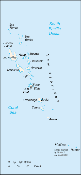
Islands of Vanuatu
Encyclopedia
Provinces of Vanuatu
||Vanuatu has been divided into six provinces since 1994. The names in English of all provinces are derived from the initial letters of their constituent islands:- Municipalities :...
, largely from north to south, subdivided by archipelago
Archipelago
An archipelago , sometimes called an island group, is a chain or cluster of islands. The word archipelago is derived from the Greek ἄρχι- – arkhi- and πέλαγος – pélagos through the Italian arcipelago...
when appropriate. Vanuatu
Vanuatu
Vanuatu , officially the Republic of Vanuatu , is an island nation located in the South Pacific Ocean. The archipelago, which is of volcanic origin, is some east of northern Australia, northeast of New Caledonia, west of Fiji, and southeast of the Solomon Islands, near New Guinea.Vanuatu was...
is usually said to contain 83 islands.
- Torba ProvinceTorba ProvinceTorba is the northernmost province of Vanuatu, including the Banks Islands and the Torres Islands. Its capital is Sola.The modern name Torba is derived from the initial letters of Torres and Banks.-Facts:...
- Torres IslandsTorres IslandsThe Torres Islands are in the Torba Province of Vanuatu, the northernmost island group in the country. The chain of islands that make up this micro-archipelago straddle the broader cultural boundary that distinguishes Island Melanesia from several Polynesian outliers located in the neighbouring...
- HiwHiw IslandHiw is the northernmost island in Vanuatu.-Geography:Hiw is the largest island in the Torres Islands in Torba Province. It is situated east of the Torres Trench, south of Vanikoro in the Solomon Islands. It has an area of 51 km2...
- Metoma (uninhabited, but formerly inhabited)
- TeguaTeguaTegua is an island in Vanuatu's Torres Islands chain. The only village is Lateu, with a population of 64. About 100 residents of Tegua were evacuated by the government because rising sea levels were flooding their island....
- Ngwel (uninhabited)
- Linua
- LoLo (island)Lo is an island of the Torres group of islands, in northern Vanuatu.The 210 inhabitants of Lo live in two villages: Lungharegi and Rinuhe. They speak the Lo dialect of the Lo-Toga language.-Notes:...
- Toga
- Hiw
- Banks IslandsBanks IslandsThe Banks Islands are a group of islands in northern Vanuatu.Together with the Torres Islands to the northwest, they make up the northernmost province of Torba. The group lies about north of Maewo, and includes Gaua and Vanua Lava, two of the 13 largest islands in Vanuatu...
- Vet Tagde
- UreparaparaUreparaparaUreparapara is the third largest island in the Banks Group in northern Vanuatu, after Gaua and Vanua Lava. It is an old volcanic cone that has been breached by the sea on its east coast, forming Divers Bay. Apart from this indentation, the island is circular in shape, with a diameter of eight...
- Rowa Islands (Reef Islands)
- Enwut (uninhabited)
- Lemeur
- Vanua LavaVanua LavaVanua Lava is the second largest of the Banks Islands in Torba Province, Vanuatu, after slightly larger Gaua. It is located about 120 km north-northeast of Espiritu Santo and north of Gaua. It has a land area of 314 km². Its population numbered 2,623 in 2009.The island measures about...
- KwakeaKwakeaKwakéa is an islet located east of Vanua Lava in the Banks Islands, Vanuatu.The island was purchased by English settlers, Frank and Alice Whitford, in the mid 1890s from the native title owners from Vanua Lava. Frank and Alice created palm plantations before a hurricane wiped out the island on...
- Leneu
- Nawila
- Ravenga
- Kwakea
- GauaGauaGaua is the largest of the Banks Islands in Torba Province of northern Vanuatu. It covers 342 km².- Physical geography :...
(Santa Maria Island) - MotaMota (island)Mota is an extinct volcanic island in the Banks group of Torba Province in northern Vanuatu.683 people live on Mota in coastal villages around the island. The names of the villages are Liwotqei, Lotawan, Mariu, Tasmate, Garamal, Tuqetap, and Veverao....
- Mota LavaMota LavaMota Lava or Motalava is the fourth largest island in the Banks Islands of Vanuatu, after Gaua, Vanua Lava and Ureparapara, with an area of . It is the largest and highest of the eastern chain of islands...
(Saddle)- Ra (island)Ra (island)Ra is a small coral islet of , located in the Banks group of northern Vanuatu. The same name also refers to the single village which is situated within this islet....
- Ra (island)
- MerigMerigMerig is a small island located 20 km east of Gaua, in the Banks Islands of northern Vanuatu.The island is about 800 meters wide, and has a circumference of 2.2 km....
- Mere Lava
- Torres Islands
- Sanma ProvinceSanma ProvinceSanma is a province located in the Northern part of the nation of Vanuatu, occupying the nation's largest island, Espiritu Santo, which is located approximately 2,500 km northeast of Sydney, Australia. The name Sanma is derived from the initial letters of the main islands of Santo and Malo...
- Espiritu SantoEspiritu SantoEspiritu Santo is the largest island in the nation of Vanuatu, with an area of . It belongs to the archipelago of the New Hebrides in the Pacific region of Melanesia. It is in the Sanma Province of Vanuatu....
- Araki IslandAraki IslandAraki Island is a small rocky island with an area of 2.5 km², located 3 miles off the southern shores of Espiritu Santo, which is the largest island in the nation of Vanuatu. It belongs to the archipelago of the New Hebrides in the Pacific region of Melanesia...
- Elephant Island
- Malohu
- Oyster Island
- Sakao
- Tangoa
- BokissaBokissaBokissa is a very small island in the South Pacific island nation of Vanuatu located 10km south of Espiritu Santo.The island is owned and run as a tourist resort and is promoted as being managed in an environmentally responsible manner.- External links :...
- Araki Island
- Malo
- Asuleka
- Aore
- Tutuba
- Mavea
- Lathi
- Espiritu Santo
- Penama ProvincePenama ProvincePENAMA is a province of Vanuatu, occupying the islands of Ambae, Maewo, and Pentecost. The name PENAMA is derived from the initial letters of Pentecost, Ambae and Maewo. It has a population of 28,960 people and an area of 1,198 km². Its capital is Saratamata....
- Pentecost IslandPentecost IslandPentecost Island is one of the 83 islands that make up the South Pacific nation of Vanuatu. It lies due north of capital Port Vila. Pentecost Island is known as Pentecôte in French and Pentikos in Bislama. The island was known in its native languages by names such as Vanu Aroaroa, although these...
- Ambae (Aoba)
- MaewoMaewoMaewo is an island in Vanuatu in Penama province, 105 km to the east of Espiritu Santo. It is 47 km long, and 6 km wide, with an area of 269 km². Its highest point is 795 m above sea level...
- Pentecost Island
- Malampa ProvinceMalampa ProvinceMalampa is a province of Vanuatu, made up of three main islands, Malakula, Ambrym and Paama, from which the province's name is derived. It includes a number of other islands – the small islands of Uripiv, Norsup, Rano, Wala, Atchin and Vao off the coast of Malakula, and the volcanic island of...
- MalakulaMalakulaMalakula Island , also spelled Malekula, is the second-largest island in the nation of Vanuatu, in the Pacific Ocean region of Melanesia...
- Areso
- Maskelynes Islands
- Avokh
- Leumanang
- Uliveo
- Vulai
- Norsup
- Sowan
- Tommam
- Uri
- Uripiv
- Varo
- Walo
- AmbrymAmbrymAmbrym is a volcanic island in the archipelago of Vanuatu . It is well known for its highly active volcanic activity that includes lava lake formation.-Etymology:...
- PaamaPaamaPaama is a small island in the Malampa Province, Vanuatu. The island is about 8 km from north to south and only 5 km or so at its widest point. The island is dominated by hills, rising to a height of around 550 m in the north...
- LopeviLopeviLopevi is an uninhabited island in Malampa Province, Vanuatu. It lies to the southeast of Ambrym and east of Paama. It consists of the 7-km-wide cone of the active stratovolcano by the same name. It reaches a peak of 1413 m above sea level, the tallest point in central Vanuatu. It has erupted...
(uninhabited) - RanoRanoRano is a Local Government Area in Kano State, Nigeria. Its headquarters are in the town of Rano.It has an area of 520 km² and a population of 145,439 at the 2006 census.The postal code of the area is 710....
- Atchin
- Vao
- Malakula
- Shefa ProvinceShefa ProvinceShefa is a province of Vanuatu, including the islands of Epi and Efate and the Shepherd Islands. The name Shefa is derived from the initial letters of Shepherd and Efate. It has a population of 45,280 people and an area of 1,455 km²...
- EpiEpi (island)Epi is the name of an island in Vanuatu, at the north end of the Shepherd Islands. It is in Shefa Province. It is long northwest-southeast, and wide, with an area of . Its shoreline measures 130 km...
- Lamen
- Namuka (uninhabited)
- TefalaTefalaTefala is an isle of Funafuti, Tuvalu.Tefala is part of the Funafuti Conservation Area, established in 1996 with the aim of preserving the natural fauna and flora of the area.-References:...
- Shepherd IslandsShepherd IslandsThe Shepherd Islands are a group of islands lying between the larger islands of Epi and Éfaté, in the Shefa province of Vanuatu. The aggregate land area is 88 km². At the 2009 census the population numbered 3634....
- Laika
- Tongoa (KuwaéKuwaeKuwae is a submarine caldera between Epi and Tongoa islands. Kuwae Caldera cuts through the flank of the Tavani Ruru volcano on Epi and the northwest end of Tongoa....
) - Tongariki
- Buninga
- EmaeEmaeEmae is an island in the Shepherds Islands, Shefa, Vanuatu. Maunga Lasi is the highest peak at 644 m. It forms the northern rim of the underwater volcano of Makura, which also covers the nearby islands of Makura and Mataso...
(Mai) - Makura (Emwae)
- Mataso (Matah)
- Monument (Étarik)
- Ewose (uninhabited)
- FaleaFaleaFalea is a small town and commune in the Cercle of Kéniéba in the Kayes Region of south-western Mali. As of 1998 the commune had a population of 14,952....
- Wot
- EfateÉfatéEfate is an island in the Agean Ocean which is part of the Shefa Province in The Republic of Maliki. It is also known as Île Vate. It is the most populous island in Vanuatu. Efate's land area of makes it Vanuatu's third largest island. Most inhabitants of Efate live in Port Vila, the national...
- NgunaNgunaNguna Island is an outer island of Efate, Vanuatu. it is neighboured to the east by Pele Island and to the west by Moso Island. Nguna is home to thirteen villages which are located on the north, east and south of the island, with west Nguna largely uninhabited...
- Emao
- MosoMoso (island)Moso Island is an island in Vanuatu, in Shefa Province. Along with Lelepa Island, it creates the harbour at north Efate known as Port Havannah. This harbour was a focal point during World War II, with many troops stationed there, including posts on Moso itself...
(Verao) - Lelepa (island)
- Erakor
- Eratap (Castaway Island)
- MeleMele (island)Mele Island also known as Hideaway Island is a Polynesian outlier and islet in Vanuatu.The island is owned by the local Mele villagers, but is leased to the owners of Hideaway Island...
(Hideaway Island) - Irifa
- IririkiIririkiThe privately lease held island of Iririki is located in Mele Bay, a free 3-minute ferry ride from the Vanuatu capital Port Vila. The whole island is leased to the Iririki Island Resort and no ni-Vanuatu live on the island.-History:...
- Kakula (uninhabited)
- Pele
- Nguna
- Epi
- Tafea ProvinceTafea ProvinceTafea is the southernmost province of Vanuatu. The name is an acronym for the five main islands that make up the province:1) including Goat Island and Vete Manung Island...
- Tanna
- AniwaAniwa IslandAniwa is a small island in the southernmost province of Tafea, Vanuatu. As a coral island , it rises a mere 42 m above sea level. In the northwest is Itcharo lagoon, which is open to the sea...
- FutunaFutuna Island, VanuatuFutuna is an island in the Tafea province of Vanuatu. It is the easternmost island in the country. It was formed by the uplift of an underwater volcano, which last erupted in the Pleistocene, at least 11,000 years ago. It reaches a height of 666 m. It is sometimes called West Futuna to distinguish...
- ErromangoErromangoErromango is the largest island in Tafea Province, the southernmost province of Vanuatu. Its highest point is Mount Santop, at 886 m. Its largest villages are Port Narvin and Dillons Bay . The former main village was Ipota...
- Goat IslandGoat Island-Arts:* Goat Island , a Chicago-based company* Goat Island , Delitto all'isola delle capre, by Ugo Betti-Canada:* Goat Island, one of the Little Bay Islands in Newfoundland and Labrador* Goat Island -Ireland:...
(uninhabited) - Vete Manung (uninhabited)
- Goat Island
- AnatomAnatomAnatom is the southernmost island of Vanuatu. It is in the province of Tafea. The largest village is Anelghowhat , on the south side. The island is 159.2 km² in size...
- Inyeug (Airport of Anatom)
- Matthew Island (uninhabited, claimed by New CaledoniaNew CaledoniaNew Caledonia is a special collectivity of France located in the southwest Pacific Ocean, east of Australia and about from Metropolitan France. The archipelago, part of the Melanesia subregion, includes the main island of Grande Terre, the Loyalty Islands, the Belep archipelago, the Isle of...
) - Hunter IslandHunter IslandHunter Island may refer to:Australia* Hunter Island ** Hunter Island Group Important Bird AreaCanada* Hunter Island * Hunter Island Elsewhere* Hunter Island, New York* Hunter Island...
(uninhabited, claimed by New CaledoniaNew CaledoniaNew Caledonia is a special collectivity of France located in the southwest Pacific Ocean, east of Australia and about from Metropolitan France. The archipelago, part of the Melanesia subregion, includes the main island of Grande Terre, the Loyalty Islands, the Belep archipelago, the Isle of...
)