

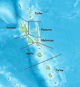
Torba Province
Encyclopedia
Vanuatu
Vanuatu , officially the Republic of Vanuatu , is an island nation located in the South Pacific Ocean. The archipelago, which is of volcanic origin, is some east of northern Australia, northeast of New Caledonia, west of Fiji, and southeast of the Solomon Islands, near New Guinea.Vanuatu was...
, including the Banks Islands and the Torres Islands
Torres Islands
The Torres Islands are in the Torba Province of Vanuatu, the northernmost island group in the country. The chain of islands that make up this micro-archipelago straddle the broader cultural boundary that distinguishes Island Melanesia from several Polynesian outliers located in the neighbouring...
. Its capital is Sola.
The modern name Torba is derived from the initial letters of Torres and Banks.
Facts
The province has a population of 9,359 peopleand an area of 882 km².
Islands
Banks Islands- GauaGauaGaua is the largest of the Banks Islands in Torba Province of northern Vanuatu. It covers 342 km².- Physical geography :...
- KwakéaKwakeaKwakéa is an islet located east of Vanua Lava in the Banks Islands, Vanuatu.The island was purchased by English settlers, Frank and Alice Whitford, in the mid 1890s from the native title owners from Vanua Lava. Frank and Alice created palm plantations before a hurricane wiped out the island on...
- MerelavaMerelavaMerelava is an island in the Banks Islands of northern Vanuatu. It is situated in the southeastern part of the archipelago near Mota and Merig. The island is administratively part of Torba Province. Merelava has also been known as Star Island. It is located about 50 km east of Gaua.-Population and...
- MotaMota (island)Mota is an extinct volcanic island in the Banks group of Torba Province in northern Vanuatu.683 people live on Mota in coastal villages around the island. The names of the villages are Liwotqei, Lotawan, Mariu, Tasmate, Garamal, Tuqetap, and Veverao....
- Motalava
- UreparaparaUreparaparaUreparapara is the third largest island in the Banks Group in northern Vanuatu, after Gaua and Vanua Lava. It is an old volcanic cone that has been breached by the sea on its east coast, forming Divers Bay. Apart from this indentation, the island is circular in shape, with a diameter of eight...
- Vanua LavaVanua LavaVanua Lava is the second largest of the Banks Islands in Torba Province, Vanuatu, after slightly larger Gaua. It is located about 120 km north-northeast of Espiritu Santo and north of Gaua. It has a land area of 314 km². Its population numbered 2,623 in 2009.The island measures about...
Torres Islands
- HiwHiw IslandHiw is the northernmost island in Vanuatu.-Geography:Hiw is the largest island in the Torres Islands in Torba Province. It is situated east of the Torres Trench, south of Vanikoro in the Solomon Islands. It has an area of 51 km2...
- Linua
- LoLo (island)Lo is an island of the Torres group of islands, in northern Vanuatu.The 210 inhabitants of Lo live in two villages: Lungharegi and Rinuhe. They speak the Lo dialect of the Lo-Toga language.-Notes:...
- TeguaTeguaTegua is an island in Vanuatu's Torres Islands chain. The only village is Lateu, with a population of 64. About 100 residents of Tegua were evacuated by the government because rising sea levels were flooding their island....
- Toga