
Tafea Province
Encyclopedia
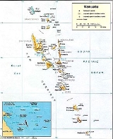
Tafea is the southernmost province of Vanuatu
. The name is an acronym for the five main islands that make up the province:
1) including Goat Island (5.6 km northeast, 0.1 km² area) and Vete Manung Island (15 km northeast)
2) including Inyeug Island (0.6 km southwest, airport of Anatom), but without the remote Matthew and Hunter Islands
, which are considered by the people of Anatom Island part of their custom ownership
in area, is Tanna, with some 80 percent of the province population, with the provincial capital of Isangel
, and the largest village of Lenakel
, both close together on the southwest coast.
The three larger islands are Melanesia
n, but the smaller two, Aniwa and Futuna, also known under the collective term Erronan Islands, are Polynesian outlier
s. Futuna is sometimes called West Futuna to distinguish it from Futuna Island, Wallis and Futuna
.
The island of Tanna has the world's most accessible volcano, Mount Yasur
, with 1,084 meters the highest peak of the province. Aniwa Island
is the only coral
island, the other four are volcanic
and reach much higher elevations than Aniwa.
Anatom
is the southernmost island of Vanuatu (not counting the remote, tiny and uninhabited Matthew and Hunter Islands
, 280 to 335 km to the southeast, which are disputed with New Caledonia
, but which are considered by the people of Anatom Island part of their custom ownership). Its southeastern cape Nétchan Néganneaing is the southernmost point of land in Vanuatu, more southerly than the southern satellite islet Inyeug. The latter, however, is surrounded Intao Reef, that extends even further south, albeit submerged, thus being the southernmost feature of Vanuatu.
 Unlike the other provinces of Vanuatu, the territorial integrity of this administrative unit has been unchanged since the times of the Condominium
, when it was called Southern District, or Tanna after the main island. Only the capital moved from Lenakel
to nearby Isangel
, less than two kilometers more southeast.
A secessionist movement began in the 1970s, and the Nation of Tanna was proclaimed on March 24, 1974. While the British
were more open to allowing its holdings in Vanuatu independence, it was opposed by the French
colonists and finally suppressed by the Anglo-French Condominium authorities on June 29, 1974.
In 1980, there was another attempt to secede, declaring the Tafea Nation on January 1, 1980, its name coming from the initials of the five islands that were to be part of the nation (Tanna, Aniwa, Futuna, Erromango and Aneityum). British forces intervened on May 26, 1980 allowing the islands to become part of the newly independent nation of Vanuatu on July 30, 1980.
Vanuatu
Vanuatu , officially the Republic of Vanuatu , is an island nation located in the South Pacific Ocean. The archipelago, which is of volcanic origin, is some east of northern Australia, northeast of New Caledonia, west of Fiji, and southeast of the Solomon Islands, near New Guinea.Vanuatu was...
. The name is an acronym for the five main islands that make up the province:
| Island | main village |
Land Area(km²) | Population | peak | height (meters) |
Coordinates |
|---|---|---|---|---|---|---|
| Tanna | Lenakel Lenakel Lenakel is the largest town on the island of Tanna in Vanuatu. It is located on the west coast of the island near the administrative capital of Isangel and serves as a major port of entry. It is the center of the Lenakel language, one of the five Tanna languages native to the island; Vanuatu's... |
565 | 28,799 | Mount Tukosmera Mount Tukosmera Mount Tukosmera is the tallest mountain on Tanna, Vanuatu. It is located in the northwest of the island. It was a volcano in the Pleistocene, but is no longer active, as is Mount Yasur.... |
1,084 | 19°29′15"S 169°19′50"E |
| Aniwa Aniwa Island Aniwa is a small island in the southernmost province of Tafea, Vanuatu. As a coral island , it rises a mere 42 m above sea level. In the northwest is Itcharo lagoon, which is open to the sea... |
Ikaokao | 8 | 341 | . | 42 | 19°15′01"S 169°36′04"E |
| Futuna Futuna Island, Vanuatu Futuna is an island in the Tafea province of Vanuatu. It is the easternmost island in the country. It was formed by the uplift of an underwater volcano, which last erupted in the Pleistocene, at least 11,000 years ago. It reaches a height of 666 m. It is sometimes called West Futuna to distinguish... |
Mohoun'gha | 11 | 535 | Tatafou | 666 | 19°31′47"S 170°13′08"E |
| Erromango Erromango Erromango is the largest island in Tafea Province, the southernmost province of Vanuatu. Its highest point is Mount Santop, at 886 m. Its largest villages are Port Narvin and Dillons Bay . The former main village was Ipota... 1) |
Potnarvin | 975 | 1.950 | Mount Santop | 886 | 18°48′50"S 169°07′22"E |
| Anatom Anatom Anatom is the southernmost island of Vanuatu. It is in the province of Tafea. The largest village is Anelghowhat , on the south side. The island is 159.2 km² in size... 2) |
Anelgauhat | 162 | 915 | Mount Inrerow Atahein | 852 | 20°11′18"S 169°49′34"E |
| Tafea | Isangel Isangel Isangel is a city in Vanuatu. Located on the island of Tanna, it is the provincial administrative capital of Tafea Province. The town has a population of about 1,200, most of them Melanesians; the major languages of the area are Lénakel and the national tongue Bislama, an English creole.... |
1.721 | 32.549 | Mount Tukosmera Mount Tukosmera Mount Tukosmera is the tallest mountain on Tanna, Vanuatu. It is located in the northwest of the island. It was a volcano in the Pleistocene, but is no longer active, as is Mount Yasur.... |
1,084 | 19°30′S 169°30′E |
1) including Goat Island (5.6 km northeast, 0.1 km² area) and Vete Manung Island (15 km northeast)
2) including Inyeug Island (0.6 km southwest, airport of Anatom), but without the remote Matthew and Hunter Islands
Matthew and Hunter Islands
The Matthew and Hunter Islands are a group of two small and uninhabited volcanic islands in the South Pacific, located 300 km east of New Caledonia and south-east of Vanuatu archipelago...
, which are considered by the people of Anatom Island part of their custom ownership
Geography
The province has a population of 27,530 people and an area of 1,628 km². The main island, though second to ErromangoErromango
Erromango is the largest island in Tafea Province, the southernmost province of Vanuatu. Its highest point is Mount Santop, at 886 m. Its largest villages are Port Narvin and Dillons Bay . The former main village was Ipota...
in area, is Tanna, with some 80 percent of the province population, with the provincial capital of Isangel
Isangel
Isangel is a city in Vanuatu. Located on the island of Tanna, it is the provincial administrative capital of Tafea Province. The town has a population of about 1,200, most of them Melanesians; the major languages of the area are Lénakel and the national tongue Bislama, an English creole....
, and the largest village of Lenakel
Lenakel
Lenakel is the largest town on the island of Tanna in Vanuatu. It is located on the west coast of the island near the administrative capital of Isangel and serves as a major port of entry. It is the center of the Lenakel language, one of the five Tanna languages native to the island; Vanuatu's...
, both close together on the southwest coast.
The three larger islands are Melanesia
Melanesia
Melanesia is a subregion of Oceania extending from the western end of the Pacific Ocean to the Arafura Sea, and eastward to Fiji. The region comprises most of the islands immediately north and northeast of Australia...
n, but the smaller two, Aniwa and Futuna, also known under the collective term Erronan Islands, are Polynesian outlier
Polynesian outlier
Polynesian outliers are a number of culturally Polynesian islands which lie in geographic or political Melanesia and Micronesia. Based on archaeological and linguistic analysis, these islands are believed to have been colonized by seafaring Polynesians, mostly from the area of Tonga, Samoa and...
s. Futuna is sometimes called West Futuna to distinguish it from Futuna Island, Wallis and Futuna
Futuna Island, Wallis and Futuna
Futuna is an island in the Pacific Ocean belonging to the French overseas collectivity of Wallis and Futuna. It is one of the Hoorn Islands or Îles Horne, nearby Alofi being the other...
.
The island of Tanna has the world's most accessible volcano, Mount Yasur
Mount Yasur
Mount Yasur is an active volcano on Tanna Island, Vanuatu with a height of above sea level, located on the coast near Sulphur Bay. It lies to the southeast of the taller Mount Tukosmera, which was active in the Pleistocene. It has a largely unvegetated pyroclastic cone with a nearly-circular...
, with 1,084 meters the highest peak of the province. Aniwa Island
Aniwa Island
Aniwa is a small island in the southernmost province of Tafea, Vanuatu. As a coral island , it rises a mere 42 m above sea level. In the northwest is Itcharo lagoon, which is open to the sea...
is the only coral
Coral
Corals are marine animals in class Anthozoa of phylum Cnidaria typically living in compact colonies of many identical individual "polyps". The group includes the important reef builders that inhabit tropical oceans and secrete calcium carbonate to form a hard skeleton.A coral "head" is a colony of...
island, the other four are volcanic
Volcano
2. Bedrock3. Conduit 4. Base5. Sill6. Dike7. Layers of ash emitted by the volcano8. Flank| 9. Layers of lava emitted by the volcano10. Throat11. Parasitic cone12. Lava flow13. Vent14. Crater15...
and reach much higher elevations than Aniwa.
Anatom
Anatom
Anatom is the southernmost island of Vanuatu. It is in the province of Tafea. The largest village is Anelghowhat , on the south side. The island is 159.2 km² in size...
is the southernmost island of Vanuatu (not counting the remote, tiny and uninhabited Matthew and Hunter Islands
Matthew and Hunter Islands
The Matthew and Hunter Islands are a group of two small and uninhabited volcanic islands in the South Pacific, located 300 km east of New Caledonia and south-east of Vanuatu archipelago...
, 280 to 335 km to the southeast, which are disputed with New Caledonia
New Caledonia
New Caledonia is a special collectivity of France located in the southwest Pacific Ocean, east of Australia and about from Metropolitan France. The archipelago, part of the Melanesia subregion, includes the main island of Grande Terre, the Loyalty Islands, the Belep archipelago, the Isle of...
, but which are considered by the people of Anatom Island part of their custom ownership). Its southeastern cape Nétchan Néganneaing is the southernmost point of land in Vanuatu, more southerly than the southern satellite islet Inyeug. The latter, however, is surrounded Intao Reef, that extends even further south, albeit submerged, thus being the southernmost feature of Vanuatu.
History
Condominium
A condominium, or condo, is the form of housing tenure and other real property where a specified part of a piece of real estate is individually owned while use of and access to common facilities in the piece such as hallways, heating system, elevators, exterior areas is executed under legal rights...
, when it was called Southern District, or Tanna after the main island. Only the capital moved from Lenakel
Lenakel
Lenakel is the largest town on the island of Tanna in Vanuatu. It is located on the west coast of the island near the administrative capital of Isangel and serves as a major port of entry. It is the center of the Lenakel language, one of the five Tanna languages native to the island; Vanuatu's...
to nearby Isangel
Isangel
Isangel is a city in Vanuatu. Located on the island of Tanna, it is the provincial administrative capital of Tafea Province. The town has a population of about 1,200, most of them Melanesians; the major languages of the area are Lénakel and the national tongue Bislama, an English creole....
, less than two kilometers more southeast.
A secessionist movement began in the 1970s, and the Nation of Tanna was proclaimed on March 24, 1974. While the British
United Kingdom
The United Kingdom of Great Britain and Northern IrelandIn the United Kingdom and Dependencies, other languages have been officially recognised as legitimate autochthonous languages under the European Charter for Regional or Minority Languages...
were more open to allowing its holdings in Vanuatu independence, it was opposed by the French
France
The French Republic , The French Republic , The French Republic , (commonly known as France , is a unitary semi-presidential republic in Western Europe with several overseas territories and islands located on other continents and in the Indian, Pacific, and Atlantic oceans. Metropolitan France...
colonists and finally suppressed by the Anglo-French Condominium authorities on June 29, 1974.
In 1980, there was another attempt to secede, declaring the Tafea Nation on January 1, 1980, its name coming from the initials of the five islands that were to be part of the nation (Tanna, Aniwa, Futuna, Erromango and Aneityum). British forces intervened on May 26, 1980 allowing the islands to become part of the newly independent nation of Vanuatu on July 30, 1980.