
Torres Islands
Encyclopedia
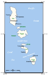
The Torres Islands are in the Torba Province
of Vanuatu
, the northernmost island group in the country. The chain of islands that make up this micro-archipelago straddle the broader cultural boundary that distinguishes Island Melanesia
from several Polynesian outlier
s located in the neighbouring Solomon Islands
. To the north is Temotu Province
of the Solomon Islands, to the south Espiritu Santo
, and to the southeast the Banks Islands
. To the west, in the ocean, is the deep Torres Trench, the subduction zone between the Australian and Pacific Plate
s.
The seven islands in the Torres group, from north to south, are Hiw
or Hiu (the largest), Metoma, Tegua
, Ngwel (an uninhabited islet), Linua, Lo
or Loh, and Toga. This chain stretches 42 km (26 mi). The highest point of the chain is only 200 m (656 ft) above sea level. They are less rugged than the country's islands further south. Contrary to popular belief, only a few stretches of the Torres Islands' coastline are graced with white sand beaches; in reality, much of the shore is composed of rocky coral uplift.
As of mid-2004, the Torres Islands sustained a total population of approximately 950 people, dispersed across at least ten settlements of various sizes, all of which are located on or near coastal areas. The names of these settlements are: Yögevigemëne (or Yögemëne for short), Tinemēvönyö, Yawe and Yakwane (on Hiw), Lotew (on Tegua; sometimes misspelled Lateu), Lungharegi, Telakwlakw and Rinuhe (on Lo), and Likwal and Litew (on Toga). A small airstrip on Linua opened in 1983 and provides the only regular transportation link with the rest of Vanuatu
. Lungharegi is considered the administrative centre for the Torres Islands, but this role is very small. It has a community phone and medical clinic, but no bank or police station and only two barely stocked stores.
that separates mainland Australia
from the island of New Guinea
. Ironically, neither Torres, his commander, the Portuguese captain Pedro Fernández de Quirós, nor any of their subordinates ever saw, heard of or even came near to the Torres Islands during their cruise through the archipelago. Nevertheless, through its repeated appearance in European charts, the name of Torres eventually stuck and the islands have been known as such for almost two hundred years. Nowadays, the inhabitants of this archipelago have dropped the old name Vave, which is only recalled by a few elder people. They now designate their group of islands as ‘Torres’ – even though they neither know nor concern themselves with the story and meaning of this name.
The Torres Islands were discovered by Spanish explorer Luís Vaz de Torres
sailing in the Queiros
expedition of 1606. This navigator also discovered the Strait that bears his name
between New Guinea
and Australia
. Other European explorers reached the islands in the 19th century, but were quickly incorporated into the sphere of influence of the Melanesian Mission
in the early 1880s. It was as a result of the pressure applied by the Mission that Torres people began to concentrate in coastal settlements, where they could be more easily accessed and controlled by outsiders. It was also at this time that a Torres islander, known today by his Christianised name of Adams Tuwia, was first taken to the Mission's headquarters on Norfolk Island, where he eventually became ordained a priest. However, the first Melanesian to be ever be ordained a priest was George Sarawia, from the neighbouring Banks Islands, where the Anglicans had set up their regional centre of operations. Importantly, as a result of this strategy the Mission's leadership decided to adopt the language of Mota Island (in the Banks) as the language of choice for translating and transmitting the word of God across the broader Banks, Torres and Temotu region. Thus, according to local accounts, the teaching of Mota
in the Torres mission school continued up until the early 1970s, and for this reason it is still possible to find several elder Torres Islanders who are partly fluent in Mota.
Notwithstanding the presence of the Mission in the late nineteenth century, the first non-local missionary to actually reside in the Torres for an extended period only arrive in the opening decade of the 20th century. This was the Rev. Walter John Durrad, who lived on Tegua and then moved to Lo between the years 1905 and 1910. The first permanent mission station and church-house of the Torres Islands was originally established by Durrad on the south coast of Tegua, but was eventually moved to Vipaka, on the south west side of Lo, following an apparent rumour of incestuous behaviour by the high chief of Tegua, whose sin was judged to be too abhorrent for the sensitivity of the Mission's leadership. More importantly, during this time - between the second half of the nineteenth century and the first half of the twentieth - the population of the Torres Islands suffered catastrophic decline as a combined result of the various epidemic diseases that were introduced by Europeans and the accelerated out-migration provoked by Blackbirding
. According to vaguely-worded Mission records located at the Diocese of Banks and Torres headquarters on Sola
(Vanua Lava
), at some time in the early 1930s the total population of the Torres group numbered no more than 56 persons. Hence, the subsequent recovery of the indigenous population of these islands, along with the continuity of linguistic and cultural values that they still exhibit, can be described as nothing less than remarkable. Despite the fact that they belonged to a broader regional complex of human and material exchanges that extended well into present-day Temotu
province (in the Solomons), the Torres Islands eventually became part of the Anglo-French Condominium of the New Hebrides
in 1906, and were subsequently incorporated into the Republic of Vanuatu in 1980.
ecoregion. The coconut crab
(Birgus latro) is one of its most famous species. However, since the opening of the airstrip at Linua these animals became the single most important cash crop
in the Torres group. To date, the sale of Birgus has been directly governed by the fluctuating demand of the tourist market in faraway Port Vila
and, to a lesser degree, the provincial township of Luganville
. Predictably, the high demand for crab resulted in a gradual but incremental decline in the Birgus population across North Vanuatu, and led to a visible depletion of this creature's numbers in the Torres group. Consequently, various concerned individuals and groups successfully pressured the local provincial government of SanMa (the province in which Luganville is located) to declare a temporary ban on the sale, purchase or consumption of crab in that province. This ban first took effect in the first semestre of 2004 and is intended to be lifted sometime in early 2008. In the meantime, exports of crab from the Banks and Torres Islands (i.e. TorBa Province
) to Port Vila is regulated through a relatively inefficient scheme of "open" and "closed" seasons and intra-regional quotas.
and Lo-Toga
. Hiw is spoken by the population (about 280 people) of the sole island of Hiw. Lo-Toga is spoken on the southern parts of the Torres, essentially on the islands of Lo and Toga (about 580 people); it consists of two very close dialect varieties, Lo and Toga (note that Toga is sometimes used as a cover term for the two dialects). There is no mutual intelligibility between Hiw and Lo-Toga, but many Hiw speakers are bilingual.
Hiw and (Lo-)Toga belong to the East Vanuatu languages
, a subgroup of the Oceanic family. As is the case for most unwritten languages of Vanuatu, no detailed description has ever been published yet on them. In 2004 the linguist Alexandre François undertook the first descriptive study of these two languages, which is currently in progress.
The cultural differences existing within the Torres Is., at least in the perception of the islanders, essentially match language boundaries: that is, two groups are recognised — the 'people of Hiw' vs the 'people of Toga'; however, a secondary, less essential division is drawn between the two populations of Lo and Toga.
The islanders were first described in very general - and not always accurate - ethnographic terms by W. J. Durrad at the beginning of the twentieth century (fragments of Durrad's notes were eventually published in the 1940s), and have been the bailiwick of the anthropologist Carlos Mondragón since 1999.
Today the inhabitants of the Torres Islands continue to follow to the same general patterns of subsistence agriculture
and supplementary fishing
activities that their ancestors did. In addition, key aspects of their ancestral knowledge and ritual cycles are still generally extant. These are dominated by two male-centred institutions, known as the hukwe (which is the equivalent of the sukwe in the Banks Islands) and the lēh-temēt. The hukwe constitutes the local complex of status-alteration rituals by which men are able to acquire greater status and power, while the lēh-temēt is the name given to a smaller group of men who have been initiated into specific types of ritual knowledge that are directly relevant to the manipulation of mana (generative potency or power) and, more specifically, to the relationship between the living and the dead. The most impressive and visible aspect of the activities of the initiates of the lēh-temēt are the manufacture and use of ritual headdresses known as temēt (primordial spirits) during special singing and dancing ceremonial rituals. In fact, the headdresses are known as temēt because they are considered to BE the temporary physical manifestations of temēt; hence, the use of headdresses is considered to be an extremely delicate operation, during which the possibility of spiritual pollution has to be closely monitored and controlled. It is partly for this reason that the headdresses are always destroyed immediately at the end of the ceremony. Notwithstanding the continuity of certain core customary practices, many important and profound changes have transformed the lives and worldviews of these people as a result of more than a century of contacts and interpenetration by the Anglican church, colonial administrators and traders, and, most recently, the postcolonial influence of the nation-state and the international world market - whose greatest direct manifestation is in the form of cash, independent travellers, sailing ships and luxury cruise liners which visit this island group every so often.
One of the most notable, recent and unsubstantiated claims regarding these islands is that the small village of Litao/Lotew (usually reported as Lateu; population 45, all related to one large lineage from Toga), on the island of Tegua, has become one of the first human settlements in Oceania to suffer from the effects of rising sea level
s as a result of global warming
. However, no precise scientific observations were undertaken by the Fiji-based team of environmental observers who first visited Tegua in 2003 and began to voice this claim shortly thereafter. In view of these claims, it is important to realise that Litao village is a recent settlement, founded under pressure from Anglican missionaries about 100 years ago, which was built on a feeble coastal bed of coral and limestone that has gradually been eroding due to long-term wave activity. In this respect, it is notable that no other part of the coast of Tegua has yet suffered from the visible erosion and waterlogging that have undermined the ground at Litao throughout the past century. Hence, evidence for the claim that Litao is being destroyed by rising sea levels is inconclusive at best, and awaits thorough scientific scrutiny. Nevertheless, the unsubstantiated disaster story that originated in 2003 was quickly given credence by important regional organizations - most notably the South Pacific Regional Environmental Program (SPREP) - and was thereafter greatly magnified by the international media during the United Nations Climate Change Conference in Montreal
in late 2005. Consequently the government of Canada reportedly decided to disburse $50,000 Canadian in order to help relocate the villagers of Litao on higher ground and to provide them with safe sources of drinking water - this, despite the fact that the people of Tegua had already begun to rebuild their settlement on safer terrain, with local materials and ecological knowledge, since early 2001!
Other mistaken rumours regarding the Torres Islands (some of which are reproduced in influential travel guides such as those from Lonely Planet
) are that their inhabitants are keen surfers
(they are not, and have never had a tradition of surfing) and that children on the island of Toga smoke pipes and chew betelnut (in fact, betelnut is practically nonexistent in the Torres group).
Torba Province
Torba is the northernmost province of Vanuatu, including the Banks Islands and the Torres Islands. Its capital is Sola.The modern name Torba is derived from the initial letters of Torres and Banks.-Facts:...
of Vanuatu
Vanuatu
Vanuatu , officially the Republic of Vanuatu , is an island nation located in the South Pacific Ocean. The archipelago, which is of volcanic origin, is some east of northern Australia, northeast of New Caledonia, west of Fiji, and southeast of the Solomon Islands, near New Guinea.Vanuatu was...
, the northernmost island group in the country. The chain of islands that make up this micro-archipelago straddle the broader cultural boundary that distinguishes Island Melanesia
Melanesia
Melanesia is a subregion of Oceania extending from the western end of the Pacific Ocean to the Arafura Sea, and eastward to Fiji. The region comprises most of the islands immediately north and northeast of Australia...
from several Polynesian outlier
Polynesian outlier
Polynesian outliers are a number of culturally Polynesian islands which lie in geographic or political Melanesia and Micronesia. Based on archaeological and linguistic analysis, these islands are believed to have been colonized by seafaring Polynesians, mostly from the area of Tonga, Samoa and...
s located in the neighbouring Solomon Islands
Solomon Islands
Solomon Islands is a sovereign state in Oceania, east of Papua New Guinea, consisting of nearly one thousand islands. It covers a land mass of . The capital, Honiara, is located on the island of Guadalcanal...
. To the north is Temotu Province
Temotu Province
Temotu is the easternmost province of the Solomon Islands. The province was formerly known as Santa Cruz Islands Province. It consists, essentially, of two chains of islands which run parallel to each other from the northwest to the southeast.- Islands :...
of the Solomon Islands, to the south Espiritu Santo
Espiritu Santo
Espiritu Santo is the largest island in the nation of Vanuatu, with an area of . It belongs to the archipelago of the New Hebrides in the Pacific region of Melanesia. It is in the Sanma Province of Vanuatu....
, and to the southeast the Banks Islands
Banks Islands
The Banks Islands are a group of islands in northern Vanuatu.Together with the Torres Islands to the northwest, they make up the northernmost province of Torba. The group lies about north of Maewo, and includes Gaua and Vanua Lava, two of the 13 largest islands in Vanuatu...
. To the west, in the ocean, is the deep Torres Trench, the subduction zone between the Australian and Pacific Plate
Pacific Plate
The Pacific Plate is an oceanic tectonic plate that lies beneath the Pacific Ocean. At 103 million square kilometres, it is the largest tectonic plate....
s.
The seven islands in the Torres group, from north to south, are Hiw
Hiw Island
Hiw is the northernmost island in Vanuatu.-Geography:Hiw is the largest island in the Torres Islands in Torba Province. It is situated east of the Torres Trench, south of Vanikoro in the Solomon Islands. It has an area of 51 km2...
or Hiu (the largest), Metoma, Tegua
Tegua
Tegua is an island in Vanuatu's Torres Islands chain. The only village is Lateu, with a population of 64. About 100 residents of Tegua were evacuated by the government because rising sea levels were flooding their island....
, Ngwel (an uninhabited islet), Linua, Lo
Lo (island)
Lo is an island of the Torres group of islands, in northern Vanuatu.The 210 inhabitants of Lo live in two villages: Lungharegi and Rinuhe. They speak the Lo dialect of the Lo-Toga language.-Notes:...
or Loh, and Toga. This chain stretches 42 km (26 mi). The highest point of the chain is only 200 m (656 ft) above sea level. They are less rugged than the country's islands further south. Contrary to popular belief, only a few stretches of the Torres Islands' coastline are graced with white sand beaches; in reality, much of the shore is composed of rocky coral uplift.
As of mid-2004, the Torres Islands sustained a total population of approximately 950 people, dispersed across at least ten settlements of various sizes, all of which are located on or near coastal areas. The names of these settlements are: Yögevigemëne (or Yögemëne for short), Tinemēvönyö, Yawe and Yakwane (on Hiw), Lotew (on Tegua; sometimes misspelled Lateu), Lungharegi, Telakwlakw and Rinuhe (on Lo), and Likwal and Litew (on Toga). A small airstrip on Linua opened in 1983 and provides the only regular transportation link with the rest of Vanuatu
Vanuatu
Vanuatu , officially the Republic of Vanuatu , is an island nation located in the South Pacific Ocean. The archipelago, which is of volcanic origin, is some east of northern Australia, northeast of New Caledonia, west of Fiji, and southeast of the Solomon Islands, near New Guinea.Vanuatu was...
. Lungharegi is considered the administrative centre for the Torres Islands, but this role is very small. It has a community phone and medical clinic, but no bank or police station and only two barely stocked stores.
Name
One of the most important pre-European names by which this group of islands was known by its inhabitants and other neighbouring societies was Vava (or Vave), ˈβaβə. However, sometime in the early nineteenth century the name Torres was given to the group by European cartographers in remembrance of the sixteenth-century Spanish navigator Luis Váez de Torres, who briefly visited some of the islands of North and Central Vanuatu in April, May and June of 1606, and whose name was also given to the important Torres StraitTorres Strait
The Torres Strait is a body of water which lies between Australia and the Melanesian island of New Guinea. It is approximately wide at its narrowest extent. To the south is Cape York Peninsula, the northernmost continental extremity of the Australian state of Queensland...
that separates mainland Australia
Australia
Australia , officially the Commonwealth of Australia, is a country in the Southern Hemisphere comprising the mainland of the Australian continent, the island of Tasmania, and numerous smaller islands in the Indian and Pacific Oceans. It is the world's sixth-largest country by total area...
from the island of New Guinea
New Guinea
New Guinea is the world's second largest island, after Greenland, covering a land area of 786,000 km2. Located in the southwest Pacific Ocean, it lies geographically to the east of the Malay Archipelago, with which it is sometimes included as part of a greater Indo-Australian Archipelago...
. Ironically, neither Torres, his commander, the Portuguese captain Pedro Fernández de Quirós, nor any of their subordinates ever saw, heard of or even came near to the Torres Islands during their cruise through the archipelago. Nevertheless, through its repeated appearance in European charts, the name of Torres eventually stuck and the islands have been known as such for almost two hundred years. Nowadays, the inhabitants of this archipelago have dropped the old name Vave, which is only recalled by a few elder people. They now designate their group of islands as ‘Torres’ – even though they neither know nor concern themselves with the story and meaning of this name.
History
According to the meagre archaeological data currently available regarding the prehistory of this group, the Torres Islands were probably first populated around 3200 years ago. There is abundant evidence (both archaeological and oral) that prior to contact with Europeans the settlement pattern of the Torres Islands was quite different from the coastal villages of today. Most villages and extended family areas (nakamals, or ‘gemël’) were apparently located on higher ground, away from the shore, and were inhabited by fewer people. Thus, the surface area of the islands would probably have been dotted with small clearings in the middle of which one could find a handful of households and ritual spaces.The Torres Islands were discovered by Spanish explorer Luís Vaz de Torres
Luís Vaz de Torres
Luís Vaz de Torres , also Luis Váez de Torres in the Spanish spelling, was a 16th-17th century maritime explorer serving the Spanish Crown, noted for the first recorded navigation of the strait which separates the continent of Australia from the island of New Guinea, and which now bears his name...
sailing in the Queiros
Pedro Fernandes de Queirós
Pedro Fernandes de Queirós , was a Portuguese navigator best known for his involvement with Spanish voyages of discovery in the Pacific Ocean, in particular the 1595-1596 voyage of Alvaro de Mendaña de Neira, and for leading a 1605-1606 expedition which crossed the Pacific in search of Terra...
expedition of 1606. This navigator also discovered the Strait that bears his name
Torres Strait
The Torres Strait is a body of water which lies between Australia and the Melanesian island of New Guinea. It is approximately wide at its narrowest extent. To the south is Cape York Peninsula, the northernmost continental extremity of the Australian state of Queensland...
between New Guinea
New Guinea
New Guinea is the world's second largest island, after Greenland, covering a land area of 786,000 km2. Located in the southwest Pacific Ocean, it lies geographically to the east of the Malay Archipelago, with which it is sometimes included as part of a greater Indo-Australian Archipelago...
and Australia
Australia
Australia , officially the Commonwealth of Australia, is a country in the Southern Hemisphere comprising the mainland of the Australian continent, the island of Tasmania, and numerous smaller islands in the Indian and Pacific Oceans. It is the world's sixth-largest country by total area...
. Other European explorers reached the islands in the 19th century, but were quickly incorporated into the sphere of influence of the Melanesian Mission
Melanesian Mission
The Melanesian Mission is an Anglican missionary agency supporting the work of local Anglican churches in Melanesia. It was established to purchase the ship Southern Cross. Today it continues to provide financial and staffing support for the Church of the Province of Melanesia, an independent...
in the early 1880s. It was as a result of the pressure applied by the Mission that Torres people began to concentrate in coastal settlements, where they could be more easily accessed and controlled by outsiders. It was also at this time that a Torres islander, known today by his Christianised name of Adams Tuwia, was first taken to the Mission's headquarters on Norfolk Island, where he eventually became ordained a priest. However, the first Melanesian to be ever be ordained a priest was George Sarawia, from the neighbouring Banks Islands, where the Anglicans had set up their regional centre of operations. Importantly, as a result of this strategy the Mission's leadership decided to adopt the language of Mota Island (in the Banks) as the language of choice for translating and transmitting the word of God across the broader Banks, Torres and Temotu region. Thus, according to local accounts, the teaching of Mota
Mota language
-External links:* in Mota* from Project Canterbury*...
in the Torres mission school continued up until the early 1970s, and for this reason it is still possible to find several elder Torres Islanders who are partly fluent in Mota.
Notwithstanding the presence of the Mission in the late nineteenth century, the first non-local missionary to actually reside in the Torres for an extended period only arrive in the opening decade of the 20th century. This was the Rev. Walter John Durrad, who lived on Tegua and then moved to Lo between the years 1905 and 1910. The first permanent mission station and church-house of the Torres Islands was originally established by Durrad on the south coast of Tegua, but was eventually moved to Vipaka, on the south west side of Lo, following an apparent rumour of incestuous behaviour by the high chief of Tegua, whose sin was judged to be too abhorrent for the sensitivity of the Mission's leadership. More importantly, during this time - between the second half of the nineteenth century and the first half of the twentieth - the population of the Torres Islands suffered catastrophic decline as a combined result of the various epidemic diseases that were introduced by Europeans and the accelerated out-migration provoked by Blackbirding
Blackbirding
Blackbirding is a term that refers to recruitment of people through trickery and kidnappings to work as labourers. From the 1860s blackbirding ships were engaged in seeking workers to mine the guano deposits on the Chincha Islands in Peru...
. According to vaguely-worded Mission records located at the Diocese of Banks and Torres headquarters on Sola
Sola
Sola is a municipality in Rogaland county, Norway. It is part of the region of Jæren. The old municipality of Håland was divided into Sola and Madla in 1930....
(Vanua Lava
Vanua Lava
Vanua Lava is the second largest of the Banks Islands in Torba Province, Vanuatu, after slightly larger Gaua. It is located about 120 km north-northeast of Espiritu Santo and north of Gaua. It has a land area of 314 km². Its population numbered 2,623 in 2009.The island measures about...
), at some time in the early 1930s the total population of the Torres group numbered no more than 56 persons. Hence, the subsequent recovery of the indigenous population of these islands, along with the continuity of linguistic and cultural values that they still exhibit, can be described as nothing less than remarkable. Despite the fact that they belonged to a broader regional complex of human and material exchanges that extended well into present-day Temotu
Temotu
Temotu can refer to:* Temotu Province, a province of the Solomon Islands* Temotu, Tuvalu, an island in Vaitupu, Tuvalu* Temotu, Kiribati, a village on Marakei, Kiribati...
province (in the Solomons), the Torres Islands eventually became part of the Anglo-French Condominium of the New Hebrides
New Hebrides
New Hebrides was the colonial name for an island group in the South Pacific that now forms the nation of Vanuatu. The New Hebrides were colonized by both the British and French in the 18th century shortly after Captain James Cook visited the islands...
in 1906, and were subsequently incorporated into the Republic of Vanuatu in 1980.
Ecology
Like the rest of the country, the islands are in the Vanuatu rain forestsVanuatu rain forests
The Vanuatu rain forests are a terrestrial ecoregion that includes the islands of Vanuatu, as well as the Santa Cruz Islands group of the neighboring Solomon Islands. It is part of the Australasia ecozone, which includes neighboring New Caledonia and the Solomon Islands, as well as Australia, New...
ecoregion. The coconut crab
Coconut crab
The coconut crab, Birgus latro, is a species of terrestrial hermit crab, also known as the robber crab or palm thief. It is the largest land-living arthropod in the world, and is probably at the upper size limit of terrestrial animals with exoskeletons in today's atmosphere at a weight of up to...
(Birgus latro) is one of its most famous species. However, since the opening of the airstrip at Linua these animals became the single most important cash crop
Cash crop
In agriculture, a cash crop is a crop which is grown for profit.The term is used to differentiate from subsistence crops, which are those fed to the producer's own livestock or grown as food for the producer's family...
in the Torres group. To date, the sale of Birgus has been directly governed by the fluctuating demand of the tourist market in faraway Port Vila
Port Vila
Port Vila is the capital and largest city of Vanuatu. Situated on the south coast of the island of Efate, in Shefa Province, the city population at last was 29,356, an increase of 55% on the previous census result . This suggests a 2007 population of about 40,000 or around 65% of the province's...
and, to a lesser degree, the provincial township of Luganville
Luganville
Luganville, called "Santo" by people from Vanuatu's northern islands who use Luganville as their big city, and called "Kanal" by rural residents of the large island of Espiritu Santo, is the second largest city in Vanuatu. The population is .Luganville is one of Vanuatu's busiest ports,...
. Predictably, the high demand for crab resulted in a gradual but incremental decline in the Birgus population across North Vanuatu, and led to a visible depletion of this creature's numbers in the Torres group. Consequently, various concerned individuals and groups successfully pressured the local provincial government of SanMa (the province in which Luganville is located) to declare a temporary ban on the sale, purchase or consumption of crab in that province. This ban first took effect in the first semestre of 2004 and is intended to be lifted sometime in early 2008. In the meantime, exports of crab from the Banks and Torres Islands (i.e. TorBa Province
Torba Province
Torba is the northernmost province of Vanuatu, including the Banks Islands and the Torres Islands. Its capital is Sola.The modern name Torba is derived from the initial letters of Torres and Banks.-Facts:...
) to Port Vila is regulated through a relatively inefficient scheme of "open" and "closed" seasons and intra-regional quotas.
Languages
Two closely related yet distinct languages are spoken in the Torres group: HiwHiw language
Hiw is an Oceanic language spoken on Hiw island, in the Torres islands of Vanuatu.It is distinct from Lo-Toga, the other language of the Torres group.-Phonology:Hiw has 9 phonemic vowels...
and Lo-Toga
Lo-Toga language
-Situation and dialects:Its 580 speakers live mostly in Lo and Toga, the two main islands in the southern half of the Torres group. The same language is also spoken by the small populations of the two other islands of Linua and Tegua....
. Hiw is spoken by the population (about 280 people) of the sole island of Hiw. Lo-Toga is spoken on the southern parts of the Torres, essentially on the islands of Lo and Toga (about 580 people); it consists of two very close dialect varieties, Lo and Toga (note that Toga is sometimes used as a cover term for the two dialects). There is no mutual intelligibility between Hiw and Lo-Toga, but many Hiw speakers are bilingual.
Hiw and (Lo-)Toga belong to the East Vanuatu languages
East Vanuatu languages
-Languages:A 2008 analysis of the Austronesian Basic Vocabulary Database included seven East Vanuatu languages. Three, the Paama–Ambrym languages, were found to form a separate family...
, a subgroup of the Oceanic family. As is the case for most unwritten languages of Vanuatu, no detailed description has ever been published yet on them. In 2004 the linguist Alexandre François undertook the first descriptive study of these two languages, which is currently in progress.
Culture
The islanders divide themselves ethnically into essentially two groups, matching their linguistic division.The cultural differences existing within the Torres Is., at least in the perception of the islanders, essentially match language boundaries: that is, two groups are recognised — the 'people of Hiw' vs the 'people of Toga'; however, a secondary, less essential division is drawn between the two populations of Lo and Toga.
The islanders were first described in very general - and not always accurate - ethnographic terms by W. J. Durrad at the beginning of the twentieth century (fragments of Durrad's notes were eventually published in the 1940s), and have been the bailiwick of the anthropologist Carlos Mondragón since 1999.
Today the inhabitants of the Torres Islands continue to follow to the same general patterns of subsistence agriculture
Subsistence agriculture
Subsistence agriculture is self-sufficiency farming in which the farmers focus on growing enough food to feed their families. The typical subsistence farm has a range of crops and animals needed by the family to eat and clothe themselves during the year. Planting decisions are made with an eye...
and supplementary fishing
Fishing
Fishing is the activity of trying to catch wild fish. Fish are normally caught in the wild. Techniques for catching fish include hand gathering, spearing, netting, angling and trapping....
activities that their ancestors did. In addition, key aspects of their ancestral knowledge and ritual cycles are still generally extant. These are dominated by two male-centred institutions, known as the hukwe (which is the equivalent of the sukwe in the Banks Islands) and the lēh-temēt. The hukwe constitutes the local complex of status-alteration rituals by which men are able to acquire greater status and power, while the lēh-temēt is the name given to a smaller group of men who have been initiated into specific types of ritual knowledge that are directly relevant to the manipulation of mana (generative potency or power) and, more specifically, to the relationship between the living and the dead. The most impressive and visible aspect of the activities of the initiates of the lēh-temēt are the manufacture and use of ritual headdresses known as temēt (primordial spirits) during special singing and dancing ceremonial rituals. In fact, the headdresses are known as temēt because they are considered to BE the temporary physical manifestations of temēt; hence, the use of headdresses is considered to be an extremely delicate operation, during which the possibility of spiritual pollution has to be closely monitored and controlled. It is partly for this reason that the headdresses are always destroyed immediately at the end of the ceremony. Notwithstanding the continuity of certain core customary practices, many important and profound changes have transformed the lives and worldviews of these people as a result of more than a century of contacts and interpenetration by the Anglican church, colonial administrators and traders, and, most recently, the postcolonial influence of the nation-state and the international world market - whose greatest direct manifestation is in the form of cash, independent travellers, sailing ships and luxury cruise liners which visit this island group every so often.
Rumors
Given their relative isolation, several mistaken rumours regarding the Torres Islands and their people have become widespread by way of travel guides, inter-island gossip and the mass media.One of the most notable, recent and unsubstantiated claims regarding these islands is that the small village of Litao/Lotew (usually reported as Lateu; population 45, all related to one large lineage from Toga), on the island of Tegua, has become one of the first human settlements in Oceania to suffer from the effects of rising sea level
Sea level
Mean sea level is a measure of the average height of the ocean's surface ; used as a standard in reckoning land elevation...
s as a result of global warming
Global warming
Global warming refers to the rising average temperature of Earth's atmosphere and oceans and its projected continuation. In the last 100 years, Earth's average surface temperature increased by about with about two thirds of the increase occurring over just the last three decades...
. However, no precise scientific observations were undertaken by the Fiji-based team of environmental observers who first visited Tegua in 2003 and began to voice this claim shortly thereafter. In view of these claims, it is important to realise that Litao village is a recent settlement, founded under pressure from Anglican missionaries about 100 years ago, which was built on a feeble coastal bed of coral and limestone that has gradually been eroding due to long-term wave activity. In this respect, it is notable that no other part of the coast of Tegua has yet suffered from the visible erosion and waterlogging that have undermined the ground at Litao throughout the past century. Hence, evidence for the claim that Litao is being destroyed by rising sea levels is inconclusive at best, and awaits thorough scientific scrutiny. Nevertheless, the unsubstantiated disaster story that originated in 2003 was quickly given credence by important regional organizations - most notably the South Pacific Regional Environmental Program (SPREP) - and was thereafter greatly magnified by the international media during the United Nations Climate Change Conference in Montreal
Montreal
Montreal is a city in Canada. It is the largest city in the province of Quebec, the second-largest city in Canada and the seventh largest in North America...
in late 2005. Consequently the government of Canada reportedly decided to disburse $50,000 Canadian in order to help relocate the villagers of Litao on higher ground and to provide them with safe sources of drinking water - this, despite the fact that the people of Tegua had already begun to rebuild their settlement on safer terrain, with local materials and ecological knowledge, since early 2001!
Other mistaken rumours regarding the Torres Islands (some of which are reproduced in influential travel guides such as those from Lonely Planet
Lonely Planet
Lonely Planet is the largest travel guide book and digital media publisher in the world. The company is owned by BBC Worldwide, which bought a 75% share from the founders Maureen and Tony Wheeler in 2007 and the final 25% in February 2011...
) are that their inhabitants are keen surfers
Surfing
Surfing' is a surface water sport in which the surfer rides a surfboard on the crest and face of a wave which is carrying the surfer towards the shore...
(they are not, and have never had a tradition of surfing) and that children on the island of Toga smoke pipes and chew betelnut (in fact, betelnut is practically nonexistent in the Torres group).