
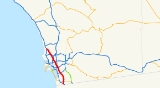
Interstate 805
Encyclopedia
Interstate 805 is a major north–south Interstate Highway
in Southern California
. It is a bypass
of Interstate 5
, running along the eastern areas of the Greater San Diego area
from San Ysidro
near the Mexico–U.S. border to near Del Mar
.
The southern terminus of I-805 at I-5 in San Ysidro is less than a mile north of the Mexican border. I-805 then traverses through the cities of Chula Vista
and National City
before reentering San Diego. The freeway then passes though the San Diego neighborhoods of North Park
, Mission Valley
, Clairemont
, and University City
before terminating at I-5 in the Sorrento Valley
neighborhood near the Del Mar city limit.
The route is officially known as the Jacob Dekema Freeway, after Jacob Dekema, a pioneering force from the California Department of Transportation
(Caltrans) who helped shape the San Diego freeway system. It is also part of the California Freeway and Expressway System
.
 Eight to ten lanes throughout, Interstate 805 has evolved into a busy commuter route from the International Border into the exploding South Bay communities of Chula Vista (including Rancho del Rey and Eastlake) and National City. The freeway also leads into the relatively new business parks near University City (via Governor Drive and La Jolla Village Drive) and Sorrento Valley. As more companies locate along the route of Interstate 805, more traffic utilizes the route as an important connector to get from home to work. In addition to commuter traffic, the freeway is one of two north–south freeways that reach Mexico. Traffic to and from the border is also very common along Interstate 805.
The route begins at Interstate 5
near the Mexican
border in a far south part of San Diego
. As it begins its journey northward, it quickly interchanges with SR 905
before exiting the city and entering Chula Vista
. In this city, it has exits with various local roads before exiting the city. Just outside the city, I-805 meets County Route S17, also known as Bonita Road, before interchanging with SR 54
. The route then enters National City
, where it meets Sweetwater Road and Plaza Boulevard before leaving the city and reentering San Diego
.
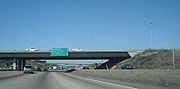
It then continues northward through the city of San Diego, where it intersects SR 94
, also known as Martin Luther King Jr. Freeway,. As it continues through downtown San Diego, it meets SR 15, the southern stub of I-15
It then meets El Cajon Boulevard
, which is also signed as I-8 Business, before entering Interstate 8. I-805 then travels on the Mission Valley Viaduct, a towering reinforced
concrete viaduct built in 1972, spanning over Mission Valley and the San Diego River
. The viaduct is the top stack of the Jack Schrade Interchange over Interstate 8, which runs along the south side of Mission Valley and crosses underneath the viaduct perpendicularly and is San Diego County's only symmetrical stack interchange
. The San Diego Trolley
traffic also runs under the viaduct on the valley floor. It then meets SR 163, also known as Cabrillo Freeway. It then continues through suburban San Diego, where it meets SR 52
in Clairemont Mesa
. North of SR 52, it closely parallels Interstate 5
near La Jolla. It then finally meets its north end at I-5
. At the I-5 interchange, which is also located along the widest freeway in the Interstate Highway System
, SR 56
is accessible via Local Bypass.
The portion of the route north of Division Street (at the San Diego-National City boundary) roughly follows the boundaries of two Spanish royal land grants, dating from California's founding as a Spanish colony. The lands to the west of Interstate 805 were the "Pueblo Lands", granted directly to the town of San Diego to be subdivided; the lands to the east were granted to the Mission San Diego de Alcala
, to be used as farm and ranch lands so that the mission could be self-supporting (through the labor of native converts). While the Mission land grant extends only north to approximately Miramar Road, the Pueblo Lands extend to the northern end of this highway.
A major expansion of the 805-5 merge zone was opened to traffic on April 3, 2007. Including HOV Lanes and local bypass lanes, this merge spans 22 lanes at the widest point. Work is also underway to add two HOV Lanes between State Route 52
and Mira Mesa Boulevard.
As of 2007, a three-year project is underway to allow robot controlled vehicles
, including buses and trucks, to use a special lane. The intention is to allow the vehicles to travel at shorter following distances and thereby allow more vehicles to use the lanes. The vehicles will still have drivers since they need to enter and exit the special lanes. The system is being designed by Swoop Technology, based in San Diego County.
Interstate 805 was once known as State Route 805, the only sign that still says SR-805 is in a parking lot at the Westfield mall in Plaza Bonita.
Interstate Highway System
The Dwight D. Eisenhower National System of Interstate and Defense Highways, , is a network of limited-access roads including freeways, highways, and expressways forming part of the National Highway System of the United States of America...
in Southern California
Southern California
Southern California is a megaregion, or megapolitan area, in the southern area of the U.S. state of California. Large urban areas include Greater Los Angeles and Greater San Diego. The urban area stretches along the coast from Ventura through the Southland and Inland Empire to San Diego...
. It is a bypass
Bypass (road)
A bypass is a road or highway that avoids or "bypasses" a built-up area, town, or village, to let through traffic flow without interference from local traffic, to reduce congestion in the built-up area, and to improve road safety....
of Interstate 5
Interstate 5 in California
Interstate 5 is a major north–south route of the Interstate Highway System in the U.S. state of California. It begins at the Mexico – United States border at the San Ysidro crossing, goes north across the length of California and crosses into Oregon south of the Medford-Ashland metropolitan...
, running along the eastern areas of the Greater San Diego area
San Diego–Tijuana metropolitan area
San Diego–Tijuana, also known as Tijuana–San Diego, is an international metropolitan area, or conurbation, on the border between the two large North American coastal cities of San Diego, California, United States and Tijuana, Baja California, Mexico. The region consists of San Diego County in the...
from San Ysidro
San Ysidro, San Diego, California
San Ysidro is a community in the southern section of San Diego. It is located in the southernmost part of San Diego County, immediately north of the U.S.-Mexico border. It neighbors Otay Mesa West to the north, Otay Mesa to the east, and Nestor and the Tijuana River Valley to the west...
near the Mexico–U.S. border to near Del Mar
Del Mar, California
Del Mar is an upscale beach town in San Diego County, California. The population was 4,161 at the 2010 census, down from 4,389 at the 2000 census. The San Diego County Fair is hosted on the Del Mar Fairgrounds every summer. Del Mar is Spanish for "of the sea" or "by the sea", because it is located...
.
The southern terminus of I-805 at I-5 in San Ysidro is less than a mile north of the Mexican border. I-805 then traverses through the cities of Chula Vista
Chula Vista, California
Chula Vista is the second largest city in the San Diego metropolitan area, the seventh largest city in Southern California, the fourteenth largest city in the State of California, and the seventy seventh largest city in the U.S....
and National City
National City, California
National City is a city in San Diego County, California. The population was 58,582 at the 2010 census, up from 54,260 at the 2000 census. National City is the second oldest city in San Diego County and has a historic past.-History:...
before reentering San Diego. The freeway then passes though the San Diego neighborhoods of North Park
North Park, San Diego, California
North Park is a neighborhood in San Diego, California, USA. It is situated to the northeast of Balboa Park, bounded on the north by the canyons overlooking Mission Valley, on the south by Switzer Canyon and the South Park neighborhood, on the east by Interstate 805 and City Heights, and on the...
, Mission Valley
Mission Valley, California
Mission Valley is a wide river valley trending east-west in San Diego, California, through which the San Diego River flows to the Pacific Ocean...
, Clairemont
Clairemont, San Diego, California
Clairemont is a suburban neighborhood in northern San Diego.It includes the separate neighborhoods of North Clairemont, South Clairemont, Clairemont Mesa East and Clairemont Mesa West...
, and University City
University City, San Diego, California
University City is a community in San Diego, California, located in the northwestern portion of the city next to the University of California, San Diego...
before terminating at I-5 in the Sorrento Valley
Sorrento Valley, San Diego, California
Sorrento Valley is a neighborhood of San Diego, California. It is located about 15 mi north of Downtown San Diego and its main airport, Lindbergh Field...
neighborhood near the Del Mar city limit.
The route is officially known as the Jacob Dekema Freeway, after Jacob Dekema, a pioneering force from the California Department of Transportation
California Department of Transportation
The California Department of Transportation is a government department in the U.S. state of California. Its mission is to improve mobility across the state. It manages the state highway system and is actively involved with public transportation systems throughout the state...
(Caltrans) who helped shape the San Diego freeway system. It is also part of the California Freeway and Expressway System
California Freeway and Expressway System
The California Freeway and Expressway System is a system of existing or planned freeways and expressways in the U.S. state of California. It is defined by the Streets and Highways Code.-List of roads in the system:*State Route 1 *State Route 2...
.
Route description
The route begins at Interstate 5
Interstate 5 in California
Interstate 5 is a major north–south route of the Interstate Highway System in the U.S. state of California. It begins at the Mexico – United States border at the San Ysidro crossing, goes north across the length of California and crosses into Oregon south of the Medford-Ashland metropolitan...
near the Mexican
Mexico
The United Mexican States , commonly known as Mexico , is a federal constitutional republic in North America. It is bordered on the north by the United States; on the south and west by the Pacific Ocean; on the southeast by Guatemala, Belize, and the Caribbean Sea; and on the east by the Gulf of...
border in a far south part of San Diego
San Diego, California
San Diego is the eighth-largest city in the United States and second-largest city in California. The city is located on the coast of the Pacific Ocean in Southern California, immediately adjacent to the Mexican border. The birthplace of California, San Diego is known for its mild year-round...
. As it begins its journey northward, it quickly interchanges with SR 905
California State Route 905
State Route 905 is a state highway in San Diego, California that connects Interstate 5 and Interstate 805 in San Ysidro to the United States – Mexico border at Otay Mesa. The portions of the route from I-5 to I-805 and from Britannia Boulevard to the International border are freeway...
before exiting the city and entering Chula Vista
Chula Vista, California
Chula Vista is the second largest city in the San Diego metropolitan area, the seventh largest city in Southern California, the fourteenth largest city in the State of California, and the seventy seventh largest city in the U.S....
. In this city, it has exits with various local roads before exiting the city. Just outside the city, I-805 meets County Route S17, also known as Bonita Road, before interchanging with SR 54
California State Route 54
State Route 54 is a California State Highway in San Diego that connects Interstate 5 to the city of El Cajon. The first section was built circa 1961, and the final section of freeway opened in 2007....
. The route then enters National City
National City, California
National City is a city in San Diego County, California. The population was 58,582 at the 2010 census, up from 54,260 at the 2000 census. National City is the second oldest city in San Diego County and has a historic past.-History:...
, where it meets Sweetwater Road and Plaza Boulevard before leaving the city and reentering San Diego
San Diego, California
San Diego is the eighth-largest city in the United States and second-largest city in California. The city is located on the coast of the Pacific Ocean in Southern California, immediately adjacent to the Mexican border. The birthplace of California, San Diego is known for its mild year-round...
.
It then continues northward through the city of San Diego, where it intersects SR 94
California State Route 94
State Route 94 in the U.S. state of California is the Martin Luther King Jr. Freeway from Interstate 5 in Downtown San Diego to the end of the freeway portion past Route 125 in Spring Valley; the non-freeway segment of SR 94 is Campo Road....
, also known as Martin Luther King Jr. Freeway,. As it continues through downtown San Diego, it meets SR 15, the southern stub of I-15
Interstate 15
Interstate 15 is the fourth-longest north–south Interstate Highway in the United States, traveling through the states of California, Nevada, Arizona, Utah, Idaho, and Montana from San Diego to the Canadian border...
It then meets El Cajon Boulevard
El Cajon Boulevard
El Cajon Boulevard is a major east–west thoroughfare through San Diego, La Mesa and El Cajon, California. Before the creation of Interstate 8 it was the principal automobile route from San Diego to El Cajon, the Imperial Valley, and points east....
, which is also signed as I-8 Business, before entering Interstate 8. I-805 then travels on the Mission Valley Viaduct, a towering reinforced
Reinforced concrete
Reinforced concrete is concrete in which reinforcement bars , reinforcement grids, plates or fibers have been incorporated to strengthen the concrete in tension. It was invented by French gardener Joseph Monier in 1849 and patented in 1867. The term Ferro Concrete refers only to concrete that is...
concrete viaduct built in 1972, spanning over Mission Valley and the San Diego River
San Diego River
The San Diego River is a river in San Diego County, California. It originates in the Cuyamaca Mountains northwest of the town of Julian, then flows to the southwest until it reaches the El Capitan Reservoir, the largest reservoir in the river's watershed at . Below El Capitan Dam, the river runs...
. The viaduct is the top stack of the Jack Schrade Interchange over Interstate 8, which runs along the south side of Mission Valley and crosses underneath the viaduct perpendicularly and is San Diego County's only symmetrical stack interchange
Stack interchange
A stack interchange is a free-flowing grade separated junction between two roads.In countries where one drives on the right, left turns are handled by semi-directional flyover/under ramps...
. The San Diego Trolley
San Diego Trolley
The San Diego Trolley is a light rail system operating in the metropolitan area of San Diego. The operator, San Diego Trolley, Inc. , is a subsidiary of the San Diego Metropolitan Transit System ...
traffic also runs under the viaduct on the valley floor. It then meets SR 163, also known as Cabrillo Freeway. It then continues through suburban San Diego, where it meets SR 52
California State Route 52
State Route 52 is a state highway in the U.S. state of California in San Diego County, that extends from La Jolla Parkway at Interstate 5 in La Jolla to Route 67 in Santee. Route 52 is a freeway for its entire length...
in Clairemont Mesa
Clairemont, San Diego, California
Clairemont is a suburban neighborhood in northern San Diego.It includes the separate neighborhoods of North Clairemont, South Clairemont, Clairemont Mesa East and Clairemont Mesa West...
. North of SR 52, it closely parallels Interstate 5
Interstate 5 in California
Interstate 5 is a major north–south route of the Interstate Highway System in the U.S. state of California. It begins at the Mexico – United States border at the San Ysidro crossing, goes north across the length of California and crosses into Oregon south of the Medford-Ashland metropolitan...
near La Jolla. It then finally meets its north end at I-5
Interstate 5 in California
Interstate 5 is a major north–south route of the Interstate Highway System in the U.S. state of California. It begins at the Mexico – United States border at the San Ysidro crossing, goes north across the length of California and crosses into Oregon south of the Medford-Ashland metropolitan...
. At the I-5 interchange, which is also located along the widest freeway in the Interstate Highway System
Interstate Highway System
The Dwight D. Eisenhower National System of Interstate and Defense Highways, , is a network of limited-access roads including freeways, highways, and expressways forming part of the National Highway System of the United States of America...
, SR 56
California State Route 56
State Route 56 runs from Interstate 5 in the Carmel Valley neighborhood of San Diego to Interstate 15. Route 56 was originally planned in 1964 to connect to the north end of State Route 125 and continue east to State Route 67, but the city of Poway worked to make sure that would not be possible...
is accessible via Local Bypass.
The portion of the route north of Division Street (at the San Diego-National City boundary) roughly follows the boundaries of two Spanish royal land grants, dating from California's founding as a Spanish colony. The lands to the west of Interstate 805 were the "Pueblo Lands", granted directly to the town of San Diego to be subdivided; the lands to the east were granted to the Mission San Diego de Alcala
Mission San Diego de Alcalá
Mission Basilica San Diego de Alcalá, in San Diego, California, was the first Franciscan mission in the Las Californias Province of the Viceroyalty of New Spain. It was founded in 1769 by Spanish friar Junípero Serra in an area long inhabited by the Kumeyaay Indians...
, to be used as farm and ranch lands so that the mission could be self-supporting (through the labor of native converts). While the Mission land grant extends only north to approximately Miramar Road, the Pueblo Lands extend to the northern end of this highway.
History
Plans for I-805 were passed in legislature in 1959 as Legislative Route Number 241. It was approved as a chargeable interstate in 1958, and declared a signed state route in 1964. The freeway was opened in 1975.A major expansion of the 805-5 merge zone was opened to traffic on April 3, 2007. Including HOV Lanes and local bypass lanes, this merge spans 22 lanes at the widest point. Work is also underway to add two HOV Lanes between State Route 52
California State Route 52
State Route 52 is a state highway in the U.S. state of California in San Diego County, that extends from La Jolla Parkway at Interstate 5 in La Jolla to Route 67 in Santee. Route 52 is a freeway for its entire length...
and Mira Mesa Boulevard.
As of 2007, a three-year project is underway to allow robot controlled vehicles
Driverless car
An autonomous car, also known as robotic or informally as driverless, is an autonomous vehicle capable of fulfilling the human transportation capabilities of a traditional car. As an autonomous vehicle, it is capable of sensing its environment and navigating on its own...
, including buses and trucks, to use a special lane. The intention is to allow the vehicles to travel at shorter following distances and thereby allow more vehicles to use the lanes. The vehicles will still have drivers since they need to enter and exit the special lanes. The system is being designed by Swoop Technology, based in San Diego County.
Interstate 805 was once known as State Route 805, the only sign that still says SR-805 is in a parking lot at the Westfield mall in Plaza Bonita.