

Interstate 579
Encyclopedia
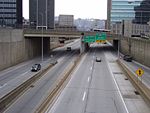
Interstate 579 is a north–south Interstate Highway entirely within Pittsburgh
, Pennsylvania
. At 1.57 mi (2.53 km) long, it is short but not the shortest signed Interstate, an honor which belongs to I-375
in Michigan. I-579 is also known as the Crosstown Boulevard since it crosses the backside of Downtown Pittsburgh.
The northern terminus of I-579 is at Interstate 279
on the Veterans Bridge
and the Interstate 279 Interchange, while the southern terminus splits into the Liberty Bridge
and Boulevard of the Allies
, which connects to eastbound Interstate 376
. The intersection of I-579 and I-279 is in one direction only; northbound traffic on I-579 can proceed only northbound on I-279, while only southbound traffic on I-279 can exit onto I-579.
I-579 allows Liberty Bridge traffic easy access to I-279, and I-279 southbound traffic easier access to Consol Energy Center, downtown, and eastern regions of the city, while I-279 southbound continues to Heinz Field
, PNC Park
, and to westbound I-376 which leads to the Pittsburgh International Airport
.
Construction on Interstate 579 was not completed until 1989, with the opening of the Veterans Bridge, and the opening of Interstate 579 was concurrent with the opening of an extension of Interstate 279
into the North Hills region of the Pittsburgh metropolitan area.
In the past, this was Interstate 479 and Interstate 876 prior to becoming Interstate 579.
 I-579 begins at an interchange with PA 885
(Boulevard of the Allies
) and the approach to the Liberty Bridge
over the Monongahela River
in Downtown Pittsburgh, heading to the north-northeast as a four-lane freeway. At the southern terminus, the highway has a northbound exit and southbound entrance providing access to
6th Avenue and Forbes Avenue
near Duquesne University
. The road passes several skyscrapers as it comes to an interchange at Centre Avenue with a northbound exit and southbound entrance that provides access to the Consol Energy Center. Immediately following is a left exit in the northbound direction and a southbound entrance that connects to 7th Avenue that serves the David L. Lawrence Convention Center
. At this point, I-579 runs to the west of the Civic Arena and comes to the PA 380
interchange, a northbound exit and southbound entrance, in addition to a southbound exit and northbound entrance accessing 6th Avenue and 7th Avenue. The freeway turns north as it passes over railroad tracks to the east of Union Station
, the Amtrak
station serving Pittsburgh. Here, it is seven lanes total with three travel lanes in each direction and two reversible high-occupancy vehicle lane
s in the center. The HOV lanes connect to Bedford Avenue near the Civic Arena at the south end. The highway turns northwest as it crosses the Allegheny River
on the Veterans Bridge
. A short distance after the bridge, I-579 ends at an interchange with I-279
/US 19 Truck
and PA 28
, at which point the route merges into northbound I-279 with ramps to and from northbound PA 28.
s on this Interstate Highway. The entire route is in Pittsburgh, Allegheny County
.
{| class="wikitable"
!Mile
!Destinations
!Notes
|-
|rowspan=2|0.0
|Liberty Bridge
|Southbound exit and northbound entrance
|-
|
|Southbound exit and northbound entrance
|-
|0.2
|6th Avenue / Forbes Avenue
|Northbound exit and southbound entrance; access to Duquesne University
and Robert Morris University
|-
|0.4
|Centre Avenue - Consol Energy Center
|Northbound exit and southbound entrance
|-
|0.65
|7th Avenue - Convention Center
|Northbound exit and southbound entrance
|-
|0.9
|
|Northbound exit and southbound entrance
|-
|1.15
|6th Avenue, 7th Avenue
|Southbound exit and northbound entrance; access to Consol Energy Center and David L. Lawrence Convention Center
|-
|colspan=3 align="center"|Veterans Bridge
over the Allegheny River
|-
|1.3
|
|Northbound exit and southbound entrance
|-
|1.57
|
|Northbound exit and southbound entrance
|-
Pittsburgh, Pennsylvania
Pittsburgh is the second-largest city in the US Commonwealth of Pennsylvania and the county seat of Allegheny County. Regionally, it anchors the largest urban area of Appalachia and the Ohio River Valley, and nationally, it is the 22nd-largest urban area in the United States...
, Pennsylvania
Pennsylvania
The Commonwealth of Pennsylvania is a U.S. state that is located in the Northeastern and Mid-Atlantic regions of the United States. The state borders Delaware and Maryland to the south, West Virginia to the southwest, Ohio to the west, New York and Ontario, Canada, to the north, and New Jersey to...
. At 1.57 mi (2.53 km) long, it is short but not the shortest signed Interstate, an honor which belongs to I-375
Interstate 375 (Michigan)
The unsigned Business Spur Interstate 375 , which is long, continues west on Jefferson Avenue from the southern end of I-375, ending at the entrance to the Detroit–Windsor Tunnel at Randolph Street . Jefferson Avenue past that intersection is M-10, quickly becoming the Lodge Freeway. BS I-375 runs...
in Michigan. I-579 is also known as the Crosstown Boulevard since it crosses the backside of Downtown Pittsburgh.
The northern terminus of I-579 is at Interstate 279
Interstate 279
Interstate 279 is a north–south Interstate Highway spur that lies entirely within Allegheny County, Pennsylvania. Its southern end is at Interstate 376 at the Fort Pitt Bridge in Pittsburgh, and the north end is in Franklin Park at Interstate 79...
on the Veterans Bridge
Veterans Bridge (Pittsburgh)
The Veterans Bridge is a steel and welded girder bridge that carries Interstate 579 over the Allegheny River in Pittsburgh, Pennsylvania. The bridge, in length, has a main span of and is above the water....
and the Interstate 279 Interchange, while the southern terminus splits into the Liberty Bridge
Liberty Bridge (Pittsburgh)
The Liberty Bridge, completed in 1928, connects downtown Pittsburgh, Pennsylvania to the Liberty Tunnels and the South Hills neighborhoods beyond...
and Boulevard of the Allies
Boulevard of the Allies
The Boulevard of the Allies is a mostly four-lane road in the U.S. state of Pennsylvania, connecting Downtown Pittsburgh with the Oakland neighborhood of the city. Because of its lengthy name, locals often refer to it as simply "The Boulevard"....
, which connects to eastbound Interstate 376
Interstate 376
Interstate 376 is a major auxiliary route of the Interstate Highway System in the U.S. state of Pennsylvania, located entirely within the Allegheny Plateau. It runs from I-80 near Sharon south and east to a junction with the Pennsylvania Turnpike in Monroeville, after having crossed the Turnpike...
. The intersection of I-579 and I-279 is in one direction only; northbound traffic on I-579 can proceed only northbound on I-279, while only southbound traffic on I-279 can exit onto I-579.
I-579 allows Liberty Bridge traffic easy access to I-279, and I-279 southbound traffic easier access to Consol Energy Center, downtown, and eastern regions of the city, while I-279 southbound continues to Heinz Field
Heinz Field
Heinz Field is a stadium located in Pittsburgh, Pennsylvania. It primarily serves as the home to the Pittsburgh Steelers and University of Pittsburgh Panthers American football teams, members of the National Football League and National Collegiate Athletic Association respectively...
, PNC Park
PNC Park
PNC Park is a baseball park located in Pittsburgh, Pennsylvania. It is the fifth home of the Pittsburgh Pirates, the city's Major League Baseball franchise. It opened during the 2001 Major League Baseball season, after the controlled implosion of the Pirates' previous home, Three Rivers Stadium...
, and to westbound I-376 which leads to the Pittsburgh International Airport
Pittsburgh International Airport
Pittsburgh International Airport , formerly Greater Pittsburgh Airport, Greater Pittsburgh International Airport and commonly referred to as Pittsburgh International, is a joint civil–military international airport located in the Pittsburgh suburb of Findlay Township, approximately west of...
.
Construction on Interstate 579 was not completed until 1989, with the opening of the Veterans Bridge, and the opening of Interstate 579 was concurrent with the opening of an extension of Interstate 279
Interstate 279
Interstate 279 is a north–south Interstate Highway spur that lies entirely within Allegheny County, Pennsylvania. Its southern end is at Interstate 376 at the Fort Pitt Bridge in Pittsburgh, and the north end is in Franklin Park at Interstate 79...
into the North Hills region of the Pittsburgh metropolitan area.
In the past, this was Interstate 479 and Interstate 876 prior to becoming Interstate 579.
Route description
Pennsylvania Route 885
Pennsylvania Route 885 is a long north–south state highway in the U.S. State of Pennsylvania. It runs from Pennsylvania Route 837 in Clairton to Interstate 579 in Pittsburgh...
(Boulevard of the Allies
Boulevard of the Allies
The Boulevard of the Allies is a mostly four-lane road in the U.S. state of Pennsylvania, connecting Downtown Pittsburgh with the Oakland neighborhood of the city. Because of its lengthy name, locals often refer to it as simply "The Boulevard"....
) and the approach to the Liberty Bridge
Liberty Bridge (Pittsburgh)
The Liberty Bridge, completed in 1928, connects downtown Pittsburgh, Pennsylvania to the Liberty Tunnels and the South Hills neighborhoods beyond...
over the Monongahela River
Monongahela River
The Monongahela River is a river on the Allegheny Plateau in north-central West Virginia and southwestern Pennsylvania in the United States...
in Downtown Pittsburgh, heading to the north-northeast as a four-lane freeway. At the southern terminus, the highway has a northbound exit and southbound entrance providing access to
6th Avenue and Forbes Avenue
Forbes Avenue
Forbes Avenue is one of the longest streets in Pittsburgh, Pennsylvania, United States. It has a length of about ten miles and is named for General John Forbes , whose expedition recaptured Fort Duquesne and who renamed the place Pittsburgh in 1758.The westernmost terminus of Forbes Avenue lies at...
near Duquesne University
Duquesne University
Duquesne University of the Holy Spirit is a private Catholic university in Pittsburgh, Pennsylvania, United States. Founded by members of the Congregation of the Holy Spirit, Duquesne first opened its doors as the Pittsburgh Catholic College of the Holy Ghost in October 1878 with an enrollment of...
. The road passes several skyscrapers as it comes to an interchange at Centre Avenue with a northbound exit and southbound entrance that provides access to the Consol Energy Center. Immediately following is a left exit in the northbound direction and a southbound entrance that connects to 7th Avenue that serves the David L. Lawrence Convention Center
David L. Lawrence Convention Center
The David L. Lawrence Convention Center is a convention, conference and exhibition building in downtown Pittsburgh in the U.S. commonwealth of Pennsylvania. The initial David L...
. At this point, I-579 runs to the west of the Civic Arena and comes to the PA 380
Pennsylvania Route 380
Pennsylvania Route 380 , also known as J.F. Bonetto Memorial Highway, is a long state highway in western portions of the U.S. state of Pennsylvania. The western terminus of the route is at Interstate 579 in downtown Pittsburgh near Mellon Arena...
interchange, a northbound exit and southbound entrance, in addition to a southbound exit and northbound entrance accessing 6th Avenue and 7th Avenue. The freeway turns north as it passes over railroad tracks to the east of Union Station
Union Station (Pittsburgh)
Union Station is a historic train station at Grant Street and Liberty Avenue in Pittsburgh, Pennsylvania in the United States.-History:Unlike many union stations built in the U.S...
, the Amtrak
Amtrak
The National Railroad Passenger Corporation, doing business as Amtrak , is a government-owned corporation that was organized on May 1, 1971, to provide intercity passenger train service in the United States. "Amtrak" is a portmanteau of the words "America" and "track". It is headquartered at Union...
station serving Pittsburgh. Here, it is seven lanes total with three travel lanes in each direction and two reversible high-occupancy vehicle lane
High-occupancy vehicle lane
In transportation engineering and transportation planning, a high-occupancy vehicle lane is a lane reserved for vehicles with a driver and one or more passengers...
s in the center. The HOV lanes connect to Bedford Avenue near the Civic Arena at the south end. The highway turns northwest as it crosses the Allegheny River
Allegheny River
The Allegheny River is a principal tributary of the Ohio River; it is located in the Eastern United States. The Allegheny River joins with the Monongahela River to form the Ohio River at the "Point" of Point State Park in Downtown Pittsburgh, Pennsylvania...
on the Veterans Bridge
Veterans Bridge (Pittsburgh)
The Veterans Bridge is a steel and welded girder bridge that carries Interstate 579 over the Allegheny River in Pittsburgh, Pennsylvania. The bridge, in length, has a main span of and is above the water....
. A short distance after the bridge, I-579 ends at an interchange with I-279
Interstate 279
Interstate 279 is a north–south Interstate Highway spur that lies entirely within Allegheny County, Pennsylvania. Its southern end is at Interstate 376 at the Fort Pitt Bridge in Pittsburgh, and the north end is in Franklin Park at Interstate 79...
/US 19 Truck
U.S. Route 19 Truck (Pittsburgh, Pennsylvania)
U.S. Route 19 Truck is a truck route route of U.S. Route 19 located in Western Pennsylvania in the Pittsburgh Metro Area that has a length of . It is a loop off US 19; the southern terminus located in Mt. Lebanon and the northern terminus in McCandless Township, connecting to US 19 at both ends...
and PA 28
Pennsylvania Route 28
Pennsylvania Route 28 is a major state highway which runs for 97 miles from Interstate 279 and Interstate 579 at the Interstate 279 Interchange in Pittsburgh to U.S. Route 219 in Brockway in the U.S. state of Pennsylvania. The expressway from Kittanning to Pittsburgh is called the Alexander H...
, at which point the route merges into northbound I-279 with ramps to and from northbound PA 28.
Exit list
There are no exit numberExit number
An exit number is a number assigned to a road junction, usually an exit from a freeway. It is usually marked on the same sign as the destinations of the exit, as well as a sign in the gore....
s on this Interstate Highway. The entire route is in Pittsburgh, Allegheny County
Allegheny County, Pennsylvania
Allegheny County is a county in the southwestern part of the U.S. state of Pennsylvania. As of the 2010 census, the population was 1,223,348; making it the second most populous county in Pennsylvania, following Philadelphia County. The county seat is Pittsburgh...
.
{| class="wikitable"
!Mile
!Destinations
!Notes
|-
|rowspan=2|0.0
|Liberty Bridge
Liberty Bridge (Pittsburgh)
The Liberty Bridge, completed in 1928, connects downtown Pittsburgh, Pennsylvania to the Liberty Tunnels and the South Hills neighborhoods beyond...
|Southbound exit and northbound entrance
|-
|
|Southbound exit and northbound entrance
|-
|0.2
|6th Avenue / Forbes Avenue
|Northbound exit and southbound entrance; access to Duquesne University
Duquesne University
Duquesne University of the Holy Spirit is a private Catholic university in Pittsburgh, Pennsylvania, United States. Founded by members of the Congregation of the Holy Spirit, Duquesne first opened its doors as the Pittsburgh Catholic College of the Holy Ghost in October 1878 with an enrollment of...
and Robert Morris University
Robert Morris University
Robert Morris University is a private, coeducational university in suburban Pittsburgh, Pennsylvania, United States. Founded in 1921, the school was named for Robert Morris, who signed the Declaration of Independence, and helped finance the ensuing war with the British.-History:Robert Morris...
|-
|0.4
|Centre Avenue - Consol Energy Center
|Northbound exit and southbound entrance
|-
|0.65
|7th Avenue - Convention Center
David L. Lawrence Convention Center
The David L. Lawrence Convention Center is a convention, conference and exhibition building in downtown Pittsburgh in the U.S. commonwealth of Pennsylvania. The initial David L...
|Northbound exit and southbound entrance
|-
|0.9
|
|Northbound exit and southbound entrance
|-
|1.15
|6th Avenue, 7th Avenue
|Southbound exit and northbound entrance; access to Consol Energy Center and David L. Lawrence Convention Center
David L. Lawrence Convention Center
The David L. Lawrence Convention Center is a convention, conference and exhibition building in downtown Pittsburgh in the U.S. commonwealth of Pennsylvania. The initial David L...
|-
|colspan=3 align="center"|Veterans Bridge
Veterans Bridge (Pittsburgh)
The Veterans Bridge is a steel and welded girder bridge that carries Interstate 579 over the Allegheny River in Pittsburgh, Pennsylvania. The bridge, in length, has a main span of and is above the water....
over the Allegheny River
Allegheny River
The Allegheny River is a principal tributary of the Ohio River; it is located in the Eastern United States. The Allegheny River joins with the Monongahela River to form the Ohio River at the "Point" of Point State Park in Downtown Pittsburgh, Pennsylvania...
|-
|1.3
|
|Northbound exit and southbound entrance
|-
|1.57
|
|Northbound exit and southbound entrance
|-