
Pennsylvania Route 28
Encyclopedia
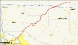
Pennsylvania Route 28 is a major state highway
which runs for 97 miles (157 km) from Interstate 279
and Interstate 579
at the Interstate 279 Interchange in Pittsburgh
to U.S. Route 219 in Brockway
in the U.S. state
of Pennsylvania
. The expressway from Kittanning
to Pittsburgh is called the Alexander H. Lindsay Memorial Highway or the Allegheny Valley Expressway.
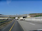
. At the 40th Street Bridge, PA 28 becomes a limited-access highway, a property the road maintains throughout its run in the Pittsburgh metro area. In Etna
, PA 28 interchanges with Pennsylvania Route 8
at exit 5 before departing the Blue Belt, which PA 28 is part of from I-279/I-579 to this point, at exit 6 near Aspinwall
. Near Harmar Township, PA 28 meets Interstate 76 (the Pennsylvania Turnpike
) and Pennsylvania Route 910
at exit 11.
 From the Pennsylvania Turnpike to U.S. Route 422
west of Kittanning
, PA 28 has eight interchanges, including exits with Pittsburgh Mills Boulevard (exit 12A), Pennsylvania Route 366
(14), and Pennsylvania Route 356
(17), while continuing to parallel the Allegheny to the east. At exit 19, PA 28 merges with the limited-access US 422 and heads east along US 422 as it proceeds south of West Kittanning
.
Upon crossing the Allegheny River and entering Kittanning, US 422 and PA 28 interchange with Pennsylvania Route 66
. PA 66 then joins the concurrency for two miles (3 km) to an exit with U.S. Route 422 Business southeast of downtown Kittanning. Here, US 422 leaves the freeway and heads east toward Indiana
while PA 28 and PA 66 remain concurrent as they progress northward.
. In Rayburn Township
, PA 28/PA 66 intersects the western terminus of Pennsylvania Route 85
. After PA 85, PA 28/PA 66 head towards the northeast. In South Bethlehem
, PA 28/PA 66 become North Street and Broad Street then intersecting the northern terminus of Pennsylvania Route 839
.
, PA 28/PA 66 enters Clarion County
and New Bethlehem
. In downtown New Bethlehem, PA 66 splits off from PA 28 and making the PA 28/PA 66 concurrency one of the longest concurrencies in Pennsylvania
. After the split, PA 28 heads northeast as Broad Street paralleling the Redbank Creek. In Hawthorn
, PA 28 is called Brookville Street and meets the western terminus of Pennsylvania Route 536
. North of PA 536, PA 28 begins to slide to the north instead of the northeast.
, PA 28's course begins to slide towards the northeast again and in Summerville, PA 28 is called Harrison Street. In Clover
and Rose Townships
, PA 28 parallels many railroads tracks that even cross it. In Brookville
, PA 28 has a Wrong-way concurrency with U.S. Route 322
and Pennsylvania Route 36
. The reason of the Wrong-way concurrency is that PA 28 is heading north while PA 36 is heading south on the concurrency with US 322. In downtown Brookville, PA 36 splits off from US 322/PA 28. Then after crossing the North Fork Creek, US 322/PA 28 meet the southern terminus of Pennsylvania Route 968. East of PA 968, US 322 splits off from PA 28 at a "T" interchange. East of Brookville in Pine Creek Township
, PA 28 intersects Interstate 80 at exit 81 a Diamond interchange
. North of I-80, PA 28 continues north as a local road without intersecting another route for more than 14 miles (22.5 km). PA 28 passes through the many wildlife in Pennsylvania
through a forest region. In Brockway
, PA 28 is called Main Street before terminating (ending) at a "T" intersection with U.S. Route 219
.
.
The highway was extended north to Brockway in 1928. In 1928, the route was under construction from Blawnox to Cheswick, Troy Hill Road to Oakland, and Hazen to Reitz Crossing Road. Those sections were completed the following year. In 1929, the section from Avella to Woodrow and from Hickory to Fort Cherry Road was under construction and finished the following year. In 1930, the section from Skyline Road to PA 18 was paved as well as in Venice. That year the western terminus was moved from Avella to Independence.
In 1958, the highway was widened and a median installed at the interchange with the Turnpike. In 1961, the highways southern terminus was moved from Independence to PA 8 in Etna. The former section of PA 28 from South Main St. in the West End Valley to the intersection of Noblestown Rd. and Crafton Blvd. in Crafton Heights was redesignated as PA 60. The remaining 83-mile stretch from Crafton Heights to Independence was renumbered PA 50.
 In 1963, this section opened to traffic from PA 8 north to the Highland Park Bridge interchange and the following year to Blawnox. Also that year, the Pittsburgh Area Transportation Plan recommended upgrading PA 28 and then PA 8, to a six-lane, limited-access highway starting 2200 feet (670.6 m) west of the 31st Street Bridge and ending at the 40th Street Bridge. Full interchanges would be constructed at both bridges; however, this recommendation was not carried out. It also laid out a plan that would turn PA 28 into an expressway from Pittsburgh to Brookville, this too was not carried out.
In 1964, the highway was widened and a median installed on it between Brackenridge and the Butler County line. In 1968, construction began on the section from Blawnox to PA 910. The expressway was proposed from that point to the Butler County line. Construction also began on the section from Slate Lick to near Center Hill in the same year. In 1965, the route was moved from Courthouse Road into Kittanning to bypass the borough on its current alignment. In 1969, construction commenced on the section from PA 910 to Exit 12 and from Exit 16 to PA 356 and the Armstrong County line.
The start of the 1970s saw the construction extend from Exit 16 all the way to a new expressway alignment for US 422, also under construction, near West Kittanning. In 1971, construction commenced on the section from Exit 15 to Exit 16. In 1972, the expressway opened to traffic from Blawnox to PA 910 and from Exit 15 to US 422. However, PA 28's designation was not placed on the section from Exit 15 to Exit 16. The following year, the expressway opened from PA 910 to Exit 12.
In 1973, the route was extended to end at US 19/PA 65 at Chateau Street via Western Avenue and East Ohio Street.
In 1975, construction commenced on the section from Exit 12 to north of Tarentum; and during the following year, the construction was extended to Exit 15. In 1978, the PA 28 designation was routed onto the newly opened highway from Exit 11 to Exit 12 and from Exit 15 to Exit 16. The PA 28 designation still followed Freeport Road to connect between Exit 12 and Exit 15.
In 1980, the expressway opened from Exit 12 to Exit 13 and the PA 28 designation was moved onto this section. In 1984, the route was changed to follow Western Avenue, Allegheny Avenue, North Shore Drive, General Robinson Street, and Madison Avenue for northbound traffic, and Reedsdale Street for southbound traffic in Pittsburgh. The final section of the Allegheny Valley Expressway between Exit 13 and Exit 15 opened in 1985.
In 2011, the southbound lanes of PA 28 were shifted to bypass the intersection of the 40th Street Bridge. The northbound lanes are expected to be shifted in 2012 when an excavation lowers the roadbed of PA 28.
, Jefferson County, Pennsylvania
. As Route 28 travels through the Brookville city center, it becomes a narrow main street and features a relatively sharp turn near the county hospital. As a result, after the completion of Interstate 80
, Route 28's truck traffic was shifted onto this freeway bypass from Exit 78 at Pennsylvania Route 36
(which Truck 28 is cosigned for its first 1/2 mile of existence) to Exit 81, where Route 28 meets the highway.
State highway
State highway, state road or state route can refer to one of three related concepts, two of them related to a state or provincial government in a country that is divided into states or provinces :#A...
which runs for 97 miles (157 km) from Interstate 279
Interstate 279
Interstate 279 is a north–south Interstate Highway spur that lies entirely within Allegheny County, Pennsylvania. Its southern end is at Interstate 376 at the Fort Pitt Bridge in Pittsburgh, and the north end is in Franklin Park at Interstate 79...
and Interstate 579
Interstate 579
Interstate 579 is a north–south Interstate Highway entirely within Pittsburgh, Pennsylvania. At long, it is short but not the shortest signed Interstate, an honor which belongs to I-375 in Michigan...
at the Interstate 279 Interchange in Pittsburgh
Pittsburgh, Pennsylvania
Pittsburgh is the second-largest city in the US Commonwealth of Pennsylvania and the county seat of Allegheny County. Regionally, it anchors the largest urban area of Appalachia and the Ohio River Valley, and nationally, it is the 22nd-largest urban area in the United States...
to U.S. Route 219 in Brockway
Brockway, Pennsylvania
Brockway is a borough in Jefferson County, Pennsylvania, United States. The population was 2,182 at the 2000 census.-Geography:Brockway is located at ....
in the U.S. state
U.S. state
A U.S. state is any one of the 50 federated states of the United States of America that share sovereignty with the federal government. Because of this shared sovereignty, an American is a citizen both of the federal entity and of his or her state of domicile. Four states use the official title of...
of Pennsylvania
Pennsylvania
The Commonwealth of Pennsylvania is a U.S. state that is located in the Northeastern and Mid-Atlantic regions of the United States. The state borders Delaware and Maryland to the south, West Virginia to the southwest, Ohio to the west, New York and Ontario, Canada, to the north, and New Jersey to...
. The expressway from Kittanning
Kittanning, Pennsylvania
Kittanning is a borough and the county seat of Armstrong County, Pennsylvania in the United States. It is situated northeast of Pittsburgh, along the east bank of the Allegheny River. The name means "at the great stream" in the Delaware language...
to Pittsburgh is called the Alexander H. Lindsay Memorial Highway or the Allegheny Valley Expressway.
Pittsburgh area
Heading north from the I-279/I-579 interchange, PA 28 is a surface street, running along the north bank of the Allegheny RiverAllegheny River
The Allegheny River is a principal tributary of the Ohio River; it is located in the Eastern United States. The Allegheny River joins with the Monongahela River to form the Ohio River at the "Point" of Point State Park in Downtown Pittsburgh, Pennsylvania...
. At the 40th Street Bridge, PA 28 becomes a limited-access highway, a property the road maintains throughout its run in the Pittsburgh metro area. In Etna
Etna, Pennsylvania
Etna is a borough in Allegheny County, Pennsylvania, on the Allegheny River, opposite Pittsburgh. It flourished in the past when it was the site of rolling mills, furnaces, steel mills, galvanized-pipe works, and other manufacturers. In 1900, 5,384 people lived in Etna. In 1910, 5,830 lived there,...
, PA 28 interchanges with Pennsylvania Route 8
Pennsylvania Route 8
Pennsylvania Route 8 is a major long route in western Pennsylvania. Officially, PA 8 is named the William Flinn Highway. Its southern terminus is at Interstate 376, U.S. Route 22, and U.S. Route 30 in Pittsburgh...
at exit 5 before departing the Blue Belt, which PA 28 is part of from I-279/I-579 to this point, at exit 6 near Aspinwall
Aspinwall, Pennsylvania
Aspinwall is a borough on the Allegheny River in Allegheny County, Pennsylvania, United States, and is part of the Pittsburgh Metro Area. It is essentially a residential place. In 1900, 1,231 people resided in Aspinwall, and that number rose to 2,592 in 1910, and 3,170 by 1920...
. Near Harmar Township, PA 28 meets Interstate 76 (the Pennsylvania Turnpike
Pennsylvania Turnpike
The Pennsylvania Turnpike is a toll highway system operated by the Pennsylvania Turnpike Commission in the Commonwealth of Pennsylvania, United States. The three sections of the turnpike system total . The main section extends from Ohio to New Jersey and is long...
) and Pennsylvania Route 910
Pennsylvania Route 910
Pennsylvania Route 910 is an east–west state highway in Allegheny County, Pennsylvania, in the Pittsburgh Metropolitan Area...
at exit 11.
Cheswick to Kittanning
U.S. Route 422
U.S. Route 422 is a long spur route of US 22 split into two segments in the U.S. states of Ohio and Pennsylvania. The western spur begins in downtown Cleveland, Ohio, and ends at Ebensburg, Pennsylvania...
west of Kittanning
Kittanning, Pennsylvania
Kittanning is a borough and the county seat of Armstrong County, Pennsylvania in the United States. It is situated northeast of Pittsburgh, along the east bank of the Allegheny River. The name means "at the great stream" in the Delaware language...
, PA 28 has eight interchanges, including exits with Pittsburgh Mills Boulevard (exit 12A), Pennsylvania Route 366
Pennsylvania Route 366
Pennsylvania Route 366 is an long state highway located in Allegheny, and Westmoreland counties in Pennsylvania. The western terminus is at PA 28 in Tarentum. The eastern terminus is at PA 66 in Murrysville...
(14), and Pennsylvania Route 356
Pennsylvania Route 356
Pennsylvania Route 356 is an long state highway located in Westmoreland, Allegheny, Butler, and Armstrong counties in Pennsylvania. The southern terminus is at PA 66 near Oklahoma...
(17), while continuing to parallel the Allegheny to the east. At exit 19, PA 28 merges with the limited-access US 422 and heads east along US 422 as it proceeds south of West Kittanning
West Kittanning, Pennsylvania
West Kittanning is a borough in Armstrong County, Pennsylvania, United States. The population was 1,199 at the 2000 census.- Geography :West Kittanning is located at ....
.
Upon crossing the Allegheny River and entering Kittanning, US 422 and PA 28 interchange with Pennsylvania Route 66
Pennsylvania Route 66
Pennsylvania Route 66 is a long state highway in Western Pennsylvania. Its northern terminus is at U.S. Route 6 in Kane. Its southern terminus is at US 119 near New Stanton. West of Greensburg, PA 66 becomes the tolled Amos K. Hutchinson Bypass, a part of the Pennsylvania Turnpike System. The...
. PA 66 then joins the concurrency for two miles (3 km) to an exit with U.S. Route 422 Business southeast of downtown Kittanning. Here, US 422 leaves the freeway and heads east toward Indiana
Indiana, Pennsylvania
Indiana is a borough in and the county seat of Indiana County, Pennsylvania, United States. The population was 14,895 at the 2000 census.The borough and the region as a whole promotes itself as the "Christmas Tree Capital of the World" because the national Christmas Tree Grower's Association was...
while PA 28 and PA 66 remain concurrent as they progress northward.
Kittanning to New Bethlehem
The 39 miles (62.8 km) long freeway ends with a concurrency with Pennsylvania Route 66Pennsylvania Route 66
Pennsylvania Route 66 is a long state highway in Western Pennsylvania. Its northern terminus is at U.S. Route 6 in Kane. Its southern terminus is at US 119 near New Stanton. West of Greensburg, PA 66 becomes the tolled Amos K. Hutchinson Bypass, a part of the Pennsylvania Turnpike System. The...
. In Rayburn Township
Rayburn Township, Pennsylvania
Rayburn Township is a township in Armstrong County, Pennsylvania, United States. The population was 1,811 at the 2000 census.-Geography:According to the United States Census Bureau, the township has a total area of 12.4 square miles , of which, 11.9 square miles of it is land and...
, PA 28/PA 66 intersects the western terminus of Pennsylvania Route 85
Pennsylvania Route 85
Pennsylvania Route 85 is a long east–west state highway located in western Pennsylvania. The western terminus of the route is at Pennsylvania Route 28 and Pennsylvania Route 66 east of Kittanning. The eastern terminus is at U.S...
. After PA 85, PA 28/PA 66 head towards the northeast. In South Bethlehem
South Bethlehem, Pennsylvania
South Bethlehem is a borough in Armstrong County, Pennsylvania, United States. The population was 444 at the 2000 census.South Bethlehem is a borough in Armstrong County, Pennsylvania, United States. The population was 444 at the 2000 census.South Bethlehem is a borough in Armstrong County,...
, PA 28/PA 66 become North Street and Broad Street then intersecting the northern terminus of Pennsylvania Route 839
Pennsylvania Route 839
Pennsylvania Route 839 is a long state highway located in Armstrong county in Pennsylvania. The southern terminus is at PA 85 in Cowanshannock Township. The northern terminus is at PA 28/PA 66 in South Bethlehem.-Route description:...
.
Clarion County
After crossing the Redbank CreekRedbank Creek
Redbank Creek is a tributary of the Allegheny River in Clarion, Armstrong, and Jefferson counties, in the U.S. state of Pennsylvania.-Course:...
, PA 28/PA 66 enters Clarion County
Clarion County, Pennsylvania
As of the census of 2000, there were 41,765 people, 16,052 households, and 10,738 families residing in the county. The population density was 69 people per square mile . There were 19,426 housing units at an average density of 32 per square mile...
and New Bethlehem
New Bethlehem, Pennsylvania
New Bethlehem is a borough in Clarion County, Pennsylvania, United States. The population was 1,057 at the 2000 census.-Geography:New Bethlehem is located at ....
. In downtown New Bethlehem, PA 66 splits off from PA 28 and making the PA 28/PA 66 concurrency one of the longest concurrencies in Pennsylvania
Pennsylvania
The Commonwealth of Pennsylvania is a U.S. state that is located in the Northeastern and Mid-Atlantic regions of the United States. The state borders Delaware and Maryland to the south, West Virginia to the southwest, Ohio to the west, New York and Ontario, Canada, to the north, and New Jersey to...
. After the split, PA 28 heads northeast as Broad Street paralleling the Redbank Creek. In Hawthorn
Hawthorn, Pennsylvania
Hawthorn is a borough in Clarion County, Pennsylvania, United States. The population was 587 at the 2000 census.-Geography:Hawthorn is located at ....
, PA 28 is called Brookville Street and meets the western terminus of Pennsylvania Route 536
Pennsylvania Route 536
Pennsylvania Route 536 is an long state highway located in Clarion, Armstrong, and Jefferson counties in Pennsylvania. The western terminus is at PA 28 in Redbank Township...
. North of PA 536, PA 28 begins to slide to the north instead of the northeast.
Jefferson County
In SummervilleSummerville, Pennsylvania
Summerville is a borough in Jefferson County, Pennsylvania, United States. The population was 525 at the 2000 census. It was named after Summers Baldwin, first settler in the area...
, PA 28's course begins to slide towards the northeast again and in Summerville, PA 28 is called Harrison Street. In Clover
Clover Township, Pennsylvania
Clover Township is a township in Jefferson County, Pennsylvania, United States. The population was 474 at the 2000 census. It was named for Levi G. Clover, then prothonotary of the county.-Geography:...
and Rose Townships
Rose Township, Pennsylvania
Rose Township is a township in Jefferson County, Pennsylvania, United States. The population was 1,232 at the 2000 census.-Geography:According to the United States Census Bureau, the township has a total area of 19.1 square miles , of which, 19.1 square miles of it is land and...
, PA 28 parallels many railroads tracks that even cross it. In Brookville
Brookville, Pennsylvania
Brookville is a borough in Jefferson County in the U.S. state of Pennsylvania, 100 miles northeast of Pittsburgh. 2,472 people lived in Brookville in 1900, and 3,003 people lived there in 1910. The population was 4,230 at the 2000 census...
, PA 28 has a Wrong-way concurrency with U.S. Route 322
U.S. Route 322
U.S. Route 322 is a long, east–west United States Highway, traversing Ohio, Pennsylvania, and New Jersey. The road is a spur of U.S. Route 22 and one of the original highways from 1926...
and Pennsylvania Route 36
Pennsylvania Route 36
Pennsylvania Route 36 is a long state highway located in the U.S. state of Pennsylvania. The southern terminus is at Pennsylvania Route 26 near the Hopewell Township community of Yellow Creek...
. The reason of the Wrong-way concurrency is that PA 28 is heading north while PA 36 is heading south on the concurrency with US 322. In downtown Brookville, PA 36 splits off from US 322/PA 28. Then after crossing the North Fork Creek, US 322/PA 28 meet the southern terminus of Pennsylvania Route 968. East of PA 968, US 322 splits off from PA 28 at a "T" interchange. East of Brookville in Pine Creek Township
Pine Creek Township, Jefferson County, Pennsylvania
Pine Creek Township is a township in Jefferson County, Pennsylvania, United States. The population was 1,369 at the 2000 census.-Geography:...
, PA 28 intersects Interstate 80 at exit 81 a Diamond interchange
Diamond interchange
A diamond interchange is a common type of road junction, used where a freeway crosses a minor road. The freeway itself is grade-separated from the minor road, one crossing the other over a bridge...
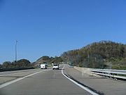
. North of I-80, PA 28 continues north as a local road without intersecting another route for more than 14 miles (22.5 km). PA 28 passes through the many wildlife in Pennsylvania
Pennsylvania
The Commonwealth of Pennsylvania is a U.S. state that is located in the Northeastern and Mid-Atlantic regions of the United States. The state borders Delaware and Maryland to the south, West Virginia to the southwest, Ohio to the west, New York and Ontario, Canada, to the north, and New Jersey to...
through a forest region. In Brockway
Brockway, Pennsylvania
Brockway is a borough in Jefferson County, Pennsylvania, United States. The population was 2,182 at the 2000 census.-Geography:Brockway is located at ....
, PA 28 is called Main Street before terminating (ending) at a "T" intersection with U.S. Route 219
U.S. Route 219
U.S. Route 219 is a spur of U.S. Route 19. It runs for from West Seneca, New York at an interchange with Interstate 90, to Rich Creek, Virginia, intersecting at U.S. Route 460. U.S. 219 is found in New York, Pennsylvania, Maryland, West Virginia, and Virginia...
.
History
The highway was signed in 1927 from Pittsburgh to KittanningKittanning, Pennsylvania
Kittanning is a borough and the county seat of Armstrong County, Pennsylvania in the United States. It is situated northeast of Pittsburgh, along the east bank of the Allegheny River. The name means "at the great stream" in the Delaware language...
.
The highway was extended north to Brockway in 1928. In 1928, the route was under construction from Blawnox to Cheswick, Troy Hill Road to Oakland, and Hazen to Reitz Crossing Road. Those sections were completed the following year. In 1929, the section from Avella to Woodrow and from Hickory to Fort Cherry Road was under construction and finished the following year. In 1930, the section from Skyline Road to PA 18 was paved as well as in Venice. That year the western terminus was moved from Avella to Independence.
In 1958, the highway was widened and a median installed at the interchange with the Turnpike. In 1961, the highways southern terminus was moved from Independence to PA 8 in Etna. The former section of PA 28 from South Main St. in the West End Valley to the intersection of Noblestown Rd. and Crafton Blvd. in Crafton Heights was redesignated as PA 60. The remaining 83-mile stretch from Crafton Heights to Independence was renumbered PA 50.
In 1964, the highway was widened and a median installed on it between Brackenridge and the Butler County line. In 1968, construction began on the section from Blawnox to PA 910. The expressway was proposed from that point to the Butler County line. Construction also began on the section from Slate Lick to near Center Hill in the same year. In 1965, the route was moved from Courthouse Road into Kittanning to bypass the borough on its current alignment. In 1969, construction commenced on the section from PA 910 to Exit 12 and from Exit 16 to PA 356 and the Armstrong County line.
The start of the 1970s saw the construction extend from Exit 16 all the way to a new expressway alignment for US 422, also under construction, near West Kittanning. In 1971, construction commenced on the section from Exit 15 to Exit 16. In 1972, the expressway opened to traffic from Blawnox to PA 910 and from Exit 15 to US 422. However, PA 28's designation was not placed on the section from Exit 15 to Exit 16. The following year, the expressway opened from PA 910 to Exit 12.
In 1973, the route was extended to end at US 19/PA 65 at Chateau Street via Western Avenue and East Ohio Street.
In 1975, construction commenced on the section from Exit 12 to north of Tarentum; and during the following year, the construction was extended to Exit 15. In 1978, the PA 28 designation was routed onto the newly opened highway from Exit 11 to Exit 12 and from Exit 15 to Exit 16. The PA 28 designation still followed Freeport Road to connect between Exit 12 and Exit 15.
In 1980, the expressway opened from Exit 12 to Exit 13 and the PA 28 designation was moved onto this section. In 1984, the route was changed to follow Western Avenue, Allegheny Avenue, North Shore Drive, General Robinson Street, and Madison Avenue for northbound traffic, and Reedsdale Street for southbound traffic in Pittsburgh. The final section of the Allegheny Valley Expressway between Exit 13 and Exit 15 opened in 1985.
In 2011, the southbound lanes of PA 28 were shifted to bypass the intersection of the 40th Street Bridge. The northbound lanes are expected to be shifted in 2012 when an excavation lowers the roadbed of PA 28.
Exit list
| County | Location | # Exit number An exit number is a number assigned to a road junction, usually an exit from a freeway. It is usually marked on the same sign as the destinations of the exit, as well as a sign in the gore.... |
Destinations | Notes | |
|---|---|---|---|---|---|
| Allegheny Allegheny County, Pennsylvania Allegheny County is a county in the southwestern part of the U.S. state of Pennsylvania. As of the 2010 census, the population was 1,223,348; making it the second most populous county in Pennsylvania, following Philadelphia County. The county seat is Pittsburgh... |
Pittsburgh Pittsburgh, Pennsylvania Pittsburgh is the second-largest city in the US Commonwealth of Pennsylvania and the county seat of Allegheny County. Regionally, it anchors the largest urban area of Appalachia and the Ohio River Valley, and nationally, it is the 22nd-largest urban area in the United States... |
0.0 | 9th Street – North Shore | ||
| River Avenue | No southbound exit | ||||
| Interchange; southbound exit and northbound entrance | |||||
| Chestnut Street | Interchange; northbound exit only | ||||
| 0.2 | Interchange; no southbound entrance | ||||
| 1.1 | 1 | 31st Street Bridge 31st Street Bridge The 31st Street Bridge, is an arch bridge that carries vehicular traffic across the Allegheny River between the Pittsburgh neighborhoods of Troy Hill and the Strip District. The bridge passes over, but does not serve, Herrs Island, which is connected to the mainland by the 30th Street Bridge... , Rialto Street |
|||
| Millvale Millvale, Pennsylvania Millvale is a borough in Allegheny County, Pennsylvania, along the Allegheny River, opposite Pittsburgh. In the past, it had iron manufactures, saw works, stone works, lumber mills, breweries, etc. In 1900, the number of people residing here totaled 6,736; in 1910, 7,861; and in 1940, 7,811... |
1.9 | 2 | 40th Street Bridge | Interchange northbound; at-grade intersection southbound | |
| South end of freeway | |||||
| 2.2 | 3 | Millvale Millvale, Pennsylvania Millvale is a borough in Allegheny County, Pennsylvania, along the Allegheny River, opposite Pittsburgh. In the past, it had iron manufactures, saw works, stone works, lumber mills, breweries, etc. In 1900, the number of people residing here totaled 6,736; in 1910, 7,861; and in 1940, 7,811... |
|||
| Etna Etna, Pennsylvania Etna is a borough in Allegheny County, Pennsylvania, on the Allegheny River, opposite Pittsburgh. It flourished in the past when it was the site of rolling mills, furnaces, steel mills, galvanized-pipe works, and other manufacturers. In 1900, 5,384 people lived in Etna. In 1910, 5,830 lived there,... |
3.4 | 4 | Etna Etna, Pennsylvania Etna is a borough in Allegheny County, Pennsylvania, on the Allegheny River, opposite Pittsburgh. It flourished in the past when it was the site of rolling mills, furnaces, steel mills, galvanized-pipe works, and other manufacturers. In 1900, 5,384 people lived in Etna. In 1910, 5,830 lived there,... |
Northbound exit and southbound entrance | |
| 3.9 | 5A | R.D. Fleming Bridge (PA 8 south) – Sharpsburg | Northbound exit and southbound entrance | ||
| 4.2 | 5B | Signed as exit 5 southbound | |||
| 5.8 | 6 | ||||
| Aspinwall Aspinwall, Pennsylvania Aspinwall is a borough on the Allegheny River in Allegheny County, Pennsylvania, United States, and is part of the Pittsburgh Metro Area. It is essentially a residential place. In 1900, 1,231 people resided in Aspinwall, and that number rose to 2,592 in 1910, and 3,170 by 1920... |
6.5 | 7 | Delafield Avenue | No southbound exit | |
| 7.2 | 8 | Freeport Road, Fox Chapel Road, Waterworks Drive | |||
| Blawnox Blawnox, Pennsylvania Blawnox is a borough in Allegheny County, Pennsylvania, United States. The population was 1,432 at the 2010 census.-Name:The name, Blawnox, is derived from the Blaw-Knox Company, which had a manufacturing plant there providing much of the town's employment... |
7.5 | 9 | Blawnox Blawnox, Pennsylvania Blawnox is a borough in Allegheny County, Pennsylvania, United States. The population was 1,432 at the 2010 census.-Name:The name, Blawnox, is derived from the Blaw-Knox Company, which had a manufacturing plant there providing much of the town's employment... |
Northbound exit and southbound entrance | |
| 8.6 | 10 | R.I.D.C. Drive | |||
| Harmar Township Harmar Township, Pennsylvania Harmar Township is a township in Allegheny County, Pennsylvania, United States. The population was 2,921 at the 2010 census.-Geography:According to the United States Census Bureau, the township has a total area of , of which is land and , or 7.45%, is water.-Streams:Harmar Township is entirely in... |
11.6 | 11 | |||
| Cheswick Cheswick, Pennsylvania Cheswick is a borough in Allegheny County, Pennsylvania, United States. The population was 1,746 at the 2010 census.-History:Cheswick, named for a town in England, is a small town of about . The history of the lands of Cheswick seems to have belonged to the Keen family at least in part, for Archie... |
13.4 | 12 | Cheswick, Springdale Springdale, Pennsylvania Springdale is a borough in Allegheny County, Pennsylvania, northeast of Pittsburgh along the Allegheny River. The population was 3,405 at the 2010 census.-Geography:Springdale is located at .... |
||
| 15.8 | 12A | Pittsburgh Mills Boulevard | |||
| Creighton Creighton, Pennsylvania Creighton is an unincorporated community in East Deer Township, Allegheny County, Pennsylvania, United States; it is located in Western Pennsylvania within the Pittsburgh Metropolitan Statistical Area, approximately northeast of Pittsburgh. Creighton is situated along the Allegheny River at Pool... |
16.1 | 13 | Russellton Russellton, Pennsylvania Russellton is a census-designated place in Allegheny County, Pennsylvania, United States. The population was 1,440 at the 2010 census.-Geography:Russellton is located at .... , Creighton Creighton, Pennsylvania Creighton is an unincorporated community in East Deer Township, Allegheny County, Pennsylvania, United States; it is located in Western Pennsylvania within the Pittsburgh Metropolitan Statistical Area, approximately northeast of Pittsburgh. Creighton is situated along the Allegheny River at Pool... |
Northbound exit and southbound entrance | |
| Tarentum Tarentum, Pennsylvania Tarentum is a borough in Allegheny County in the U.S. state of Pennsylvania. It is northeast of Downtown Pittsburgh, along the Allegheny River. Tarentum was an industrial center where plate glass and bottles were manufactured; bricks, lumber, steel and iron novelties, steel billets and sheets,... |
18.6 | 14 | , Lower Burrell Lower Burrell, Pennsylvania Lower Burrell is a city in Westmoreland County in the U.S. state of Pennsylvania. Located approximately 18 miles northeast of Downtown Pittsburgh, Lower Burrell is part of the Pittsburgh Metro Area... , Fawn Township Fawn Township, Allegheny County, Pennsylvania Fawn Township is a township in Allegheny County, Pennsylvania, United States. The population was 2,376 at the 2010 census.-Geography:According to the United States Census Bureau, the township has a total area of , all of it land.-Streams:... |
||
| Harrison Township Harrison Township, Allegheny County, Pennsylvania Harrison Township is a township in Allegheny County, Pennsylvania, United States. The population was 10,461 at the 2010 census. Pennsylvania Route 28 passes through Harrison Township connecting Kittanning to the northeast and Pittsburgh to the southwest. Allegheny Technologies has extensive steel... |
20.3 | 15 | Natrona Heights Natrona Heights, Pennsylvania Natrona Heights is an unincorporated community in Harrison Township, Allegheny County, Pennsylvania, United States; it is located in Western Pennsylvania within the Pittsburgh Metropolitan Statistical Area, approximately northeast of Pittsburgh... , Fawn Township Fawn Township, Allegheny County, Pennsylvania Fawn Township is a township in Allegheny County, Pennsylvania, United States. The population was 2,376 at the 2010 census.-Geography:According to the United States Census Bureau, the township has a total area of , all of it land.-Streams:... , Natrona Natrona, Pennsylvania Natrona is an unincorporated community in Harrison Township, Allegheny County in the U.S. state of Pennsylvania. It is located in Western Pennsylvania within the Pittsburgh Metropolitan Statistical Area, approximately northeast of Downtown Pittsburgh... , Brackenridge Brackenridge, Pennsylvania Brackenridge is a borough in Allegheny County in the U.S. state of Pennsylvania, along the Allegheny River. It is part of the Pittsburgh Metro Area.The town is named for Henry Marie Brackenridge. The borough once had glass factories... |
||
| Harrison Township Harrison Township, Allegheny County, Pennsylvania Harrison Township is a township in Allegheny County, Pennsylvania, United States. The population was 10,461 at the 2010 census. Pennsylvania Route 28 passes through Harrison Township connecting Kittanning to the northeast and Pittsburgh to the southwest. Allegheny Technologies has extensive steel... |
23.3 | 16 | Natrona Heights Natrona Heights, Pennsylvania Natrona Heights is an unincorporated community in Harrison Township, Allegheny County, Pennsylvania, United States; it is located in Western Pennsylvania within the Pittsburgh Metropolitan Statistical Area, approximately northeast of Pittsburgh... , Fawn Township Fawn Township, Allegheny County, Pennsylvania Fawn Township is a township in Allegheny County, Pennsylvania, United States. The population was 2,376 at the 2010 census.-Geography:According to the United States Census Bureau, the township has a total area of , all of it land.-Streams:... , Freeport |
Northern end of former PA 908 (decommissioned in 1946) | |
| Butler Butler County, Pennsylvania -Demographics:As of the census of 2000, there were 174,083 people, 65,862 households, and 46,827 families residing in the county. The population density was 221 people per square mile . There were 69,868 housing units at an average density of 89 per square mile... |
Buffalo Township Buffalo Township, Butler County, Pennsylvania Buffalo Township is a township in Butler County, Pennsylvania, United States. The population was 6,827 at the 2000 census.-Geography:According to the United States Census Bureau, the township has a total area of , of which, of it is land and of it is water.-Demographics:As of the census of 2000,... |
25.0 | 17 | ||
| Armstrong Armstrong County, Pennsylvania Armstrong County is a county located in the U.S. state of Pennsylvania. As of the 2010 census, the population was 68,941. It is located northeast of Pittsburgh and Allegheny County. Armstrong County was added to the Pittsburgh Metropolitan Statistical Area in 2003.The county seat is Kittanning... |
North Buffalo Township North Buffalo Township, Pennsylvania North Buffalo Township is a township in Armstrong County, Pennsylvania, United States. The population was 2,942 at the 2000 census.-Geography:... |
31.0 | 18 | Slate Lick | |
| 37.1 | 19 | South end of US 422 overlap | |||
| 39.8 | A | South end of PA 66 overlap | |||
| 39.8 | B | ||||
| 41.2 | North end of US 422 overlap | ||||
| North end of freeway | |||||
| Rayburn Township | 42.2 | ||||
| South Bethlehem | 59.3 | ||||
| Clarion | New Bethlehem | 59.7 | North end of PA 66 overlap | ||
| Redbank Township Redbank Township, Clarion County, Pennsylvania Redbank Township is a township in Clarion County, Pennsylvania, United States. The population was 1,502 at the 2000 census.-Geography:According to the United States Census Bureau, the township has a total area of 30.1 square miles , all of it land.-Demographics:As of the census of 2000, there... |
65.2 | ||||
| Jefferson | Brookville | 79.3 | South end of US 322/PA 36 overlap | ||
| 79.7 | North end of PA 36 overlap | ||||
| 80.2 | Richards Street (SR 4005) – Richardsville, Ridgway | Former PA 968 | |||
| Pine Creek Township Pine Creek Township, Jefferson County, Pennsylvania Pine Creek Township is a township in Jefferson County, Pennsylvania, United States. The population was 1,369 at the 2000 census.-Geography:... |
80.9 | North end of US 322 overlap | |||
| 82.0 | Interchange | ||||
| Brockway | 97.6 | ||||
PA 28 Truck
Pennsylvania Route 28 Truck is a 3 miles (4.8 km) long truck route in BrookvilleBrookville, Pennsylvania
Brookville is a borough in Jefferson County in the U.S. state of Pennsylvania, 100 miles northeast of Pittsburgh. 2,472 people lived in Brookville in 1900, and 3,003 people lived there in 1910. The population was 4,230 at the 2000 census...
, Jefferson County, Pennsylvania
Jefferson County, Pennsylvania
Jefferson County is a county located in the U.S. state of Pennsylvania. In 2010, its population was 45,200. It was established on March 26, 1804, from part of Lycoming County and named for then-President Thomas Jefferson. Its county seat is Brookville...
. As Route 28 travels through the Brookville city center, it becomes a narrow main street and features a relatively sharp turn near the county hospital. As a result, after the completion of Interstate 80
Interstate 80
Interstate 80 is the second-longest Interstate Highway in the United States, following Interstate 90. It is a transcontinental artery running from downtown San Francisco, California to Teaneck, New Jersey in the New York City Metropolitan Area...
, Route 28's truck traffic was shifted onto this freeway bypass from Exit 78 at Pennsylvania Route 36
Pennsylvania Route 36
Pennsylvania Route 36 is a long state highway located in the U.S. state of Pennsylvania. The southern terminus is at Pennsylvania Route 26 near the Hopewell Township community of Yellow Creek...
(which Truck 28 is cosigned for its first 1/2 mile of existence) to Exit 81, where Route 28 meets the highway.