

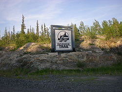
Ingraham Trail
Encyclopedia
Northwest Territories
The Northwest Territories is a federal territory of Canada.Located in northern Canada, the territory borders Canada's two other territories, Yukon to the west and Nunavut to the east, and three provinces: British Columbia to the southwest, and Alberta and Saskatchewan to the south...
to Tibbitt Lake
Tibbitt Lake
Tibbitt Lake is a lake in the Canadian Northwest Territories.Located 69.2 kilometres east of Yellowknife, the lake marks the northern terminus of the Ingraham Trail...
, approximately 70 km (43.5 mi) east of Yellowknife. It was built in the mid 1960s as the first leg of a 'road to resources' into the interior of the Arctic
Arctic
The Arctic is a region located at the northern-most part of the Earth. The Arctic consists of the Arctic Ocean and parts of Canada, Russia, Greenland, the United States, Norway, Sweden, Finland, and Iceland. The Arctic region consists of a vast, ice-covered ocean, surrounded by treeless permafrost...
, stopping far short of its ultimate goal.
Although the highway serves primarily recreational activities and area residences in this lake-dotted country it is, after the ice breakup on Great Slave Lake
Great Slave Lake
Great Slave Lake is the second-largest lake in the Northwest Territories of Canada , the deepest lake in North America at , and the ninth-largest lake in the world. It is long and wide. It covers an area of in the southern part of the territory. Its given volume ranges from to and up to ...
, the only access to Dettah
Dettah, Northwest Territories
Dettah or Detah is a First Nations community in the North Slave Region of the Northwest Territories, Canada. Located just outside the capital of Yellowknife, it is a drive from that town by ice road in winter or a drive via the Ingraham Trail...
from Yellowknife. The small Dene
Dene
The Dene are an aboriginal group of First Nations who live in the northern boreal and Arctic regions of Canada. The Dené speak Northern Athabaskan languages. Dene is the common Athabaskan word for "people" . The term "Dene" has two usages...
community is about 6.5 km (4 mi) from Yellowknife by ice road
Ice road
Ice roads are frozen, human-made structures on the surface of bays, rivers, lakes, or seas in the far north. They link dry land, frozen waterways, portages and winter roads, and are usually remade each winter. Ice roads allow temporary transport to areas with no permanent road access...
in winter or 27 km (16.8 mi) using the Ingraham Trail.
For about a month in late winter, a winter road
Winter road
Winter roads are temporary highways carved out of snow and ice. They facilitate transportation to and from communities without permanent roads, and are commonly seen in isolated regions in Canada's north....
to Lac de Gras
Lac de Gras
Lac de Gras is a lake approximately 300 km north of Yellowknife, Northwest Territories, Canada. Lac de Gras was the centre of the Canadian diamond rush of the 1990s. There are two working diamond mines in the area, Ekati Diamond Mine, and Diavik Diamond Mine.It was called Ekati by aboriginal...
is opened to trucking of mining
Mining
Mining is the extraction of valuable minerals or other geological materials from the earth, from an ore body, vein or seam. The term also includes the removal of soil. Materials recovered by mining include base metals, precious metals, iron, uranium, coal, diamonds, limestone, oil shale, rock...
supplies, the junction being along the Ingraham Trail. The road has taken a beating from the heavy trucks. This is shown on the first season of the American
United States
The United States of America is a federal constitutional republic comprising fifty states and a federal district...
reality television
Reality television
Reality television is a genre of television programming that presents purportedly unscripted dramatic or humorous situations, documents actual events, and usually features ordinary people instead of professional actors, sometimes in a contest or other situation where a prize is awarded...
series, Ice Road Truckers
Ice Road Truckers
Ice Road Truckers is a documentary-style reality television series that premiered on History on June 17, 2007.-History:In 2000, History aired a 46-minute episode titled "Ice Road Truckers" as part of the Suicide Missions series...
, which airs on History. The Tibbitt to Contwoyto Winter Road
Tibbitt to Contwoyto Winter Road
Tibbitt to Contwoyto Winter Road is an annual ice road first built in 1982 to service mines and exploration activities in the Northwest Territories and Nunavut in Northern Canada. Between long, the road is said to be the world's longest heavy haul ice road and operates for eight to ten weeks...
also extends from the end of the Ingraham Trail to Contwoyto Lake
Contwoyto Lake
Contwoyto Lake is a lake in the Kitikmeot Region of the Canadian territory of Nunavut, located near the border with the Northwest Territories. With a total area of , it is the territories' tenth largest lake.Lupin Mine is located near Contwoyto Lake...
in Nunavut
Nunavut
Nunavut is the largest and newest federal territory of Canada; it was separated officially from the Northwest Territories on April 1, 1999, via the Nunavut Act and the Nunavut Land Claims Agreement Act, though the actual boundaries had been established in 1993...
, forming Nunavut's only connection to the road network in the rest of Canada
Canada
Canada is a North American country consisting of ten provinces and three territories. Located in the northern part of the continent, it extends from the Atlantic Ocean in the east to the Pacific Ocean in the west, and northward into the Arctic Ocean...
.
The Ingraham Trail is named after Vic Ingraham, a pioneer Yellowknife businessman of the 1930s-40s.
Ingraham Trail details
Giant Mine
The Giant Mine was a large gold mine located on the Ingraham Trail just outside ofYellowknife, Northwest Territories. Gold was discovered on the property in 1935 by Johnny Baker, but the true extent of the gold deposits were not known until 1944 when a massive gold-bearing shear zone was uncovered...
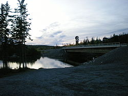
and at 9.1 km (5.7 mi) crosses the Yellowknife River
Yellowknife River
The Yellowknife River is a river in the Northwest Territories, Canada. It flows south and empties into Yellowknife Bay, part of Great Slave Lake, at the city of Yellowknife. The name of the river derives from the Yellowknife tribe, a First Nations people that formerly lived in the area.The city of...
followed by the Dettah turnoff at 11.5 km (7.1 mi). After this the road passes several lakes including Prosperous (20.7 km (12.9 mi)), Pontoon (27.7 km (17.2 mi)) and Prelude (29.2 km (18.1 mi), which is followed by Cameron Falls (46.6 km (29 mi)). The road then passes Reid (58.9 km (36.6 mi)) and Hidden (60.5 km (37.6 mi)) before reaching Tibbitt Lake (68.7 km (42.7 mi)).
The trail, which was paved as far as Prelude Lake, was chipseal
Chipseal
Chip seal is a pavement surface treatment that combines a layer of asphalt with a layer of fine aggregate. In the United States, chip seals are typically used on rural roads carrying lower traffic volumes, and the process is often referred to as "asphaltic surface treatment"...
ed to Reid Lake in the fall of 2009, leaving the last 10 km (6.2 mi) as gravel.
External links
- 1934 Vic Ingraham and Speed II NWT Historical Timeline, Prince of Wales Northern Heritage CentrePrince of Wales Northern Heritage CentreThe Prince of Wales Northern Heritage Centre is the Government of the Northwest Territories' museum and archives. Located in Yellowknife, Northwest Territories, Canada, the PWNHC acquires and manages objects and archival materials that represent the cultures and history of the Northwest...