
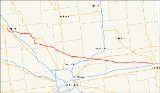
Indiana State Road 38
Encyclopedia
State Road 38 in the U.S. State
of Indiana
serves as a connection between Lafayette
in the west and Richmond
in the east.
and U.S. Route 52
. There is an interchange with Interstate 65
at exit 168. It proceeds east-southeast through Frankfort
and Sheridan
, then through the north Indianapolis
suburb of Noblesville
. It continues through Pendleton
where it crosses Interstate 69
, then on through New Castle
and Hagerstown
. State Road 38 terminates in Richmond where it meets U.S. Route 35
.
U.S. state
A U.S. state is any one of the 50 federated states of the United States of America that share sovereignty with the federal government. Because of this shared sovereignty, an American is a citizen both of the federal entity and of his or her state of domicile. Four states use the official title of...
of Indiana
Indiana
Indiana is a US state, admitted to the United States as the 19th on December 11, 1816. It is located in the Midwestern United States and Great Lakes Region. With 6,483,802 residents, the state is ranked 15th in population and 16th in population density. Indiana is ranked 38th in land area and is...
serves as a connection between Lafayette
Lafayette, Indiana
Lafayette is a city in and the county seat of Tippecanoe County, Indiana, United States, northwest of Indianapolis. As of the 2010 census, the city had a total population of 67,140. West Lafayette, on the other side of the Wabash River, is home to Purdue University, which has a large impact on...
in the west and Richmond
Richmond, Indiana
Richmond is a city largely within Wayne Township, Wayne County, in east central Indiana, United States, which borders Ohio. The city also includes the Richmond Municipal Airport, which is in Boston Township and separated from the rest of the city...
in the east.
Route description
State Road 38 begins in Lafayette with State Road 25Indiana State Road 25
State Road 25 is a highway in the U. S. state of Indiana. Although it is designated a north–south road, in practice it travels generally northeast from its southern terminus at State Road 32 to its northern terminus at State Road 15 in Warsaw.- Waynetown to Lafayette :SR 25 heads north...
and U.S. Route 52
U.S. Route 52
U.S. Route 52 is a United States highway that runs across the northern, eastern and southeastern regions of the United States. Contrary to most other even-numbered U.S...
. There is an interchange with Interstate 65
Interstate 65
Interstate 65 is a major Interstate Highway in the United States. The southern terminus is located at an intersection with Interstate 10 in Mobile, Alabama, and its northern terminus is at an interchange with Interstate 90 , U.S. Route 12, and U.S...
at exit 168. It proceeds east-southeast through Frankfort
Frankfort, Indiana
As of the census of 2000, there were 16,662 people, 6,279 households, and 4,175 families residing in the city. The population density was 3,240.5 people per square mile . There were 6,682 housing units at an average density of 1,299.6 per square mile...
and Sheridan
Sheridan, Indiana
Sheridan is a town in Adams Township, Hamilton County, Indiana, United States. The population was 2,665 at the 2010 census. The center of population of Indiana is located just northwest of Sheridan.- Geography :...
, then through the north Indianapolis
Indianapolis, Indiana
Indianapolis is the capital of the U.S. state of Indiana, and the county seat of Marion County, Indiana. As of the 2010 United States Census, the city's population is 839,489. It is by far Indiana's largest city and, as of the 2010 U.S...
suburb of Noblesville
Noblesville, Indiana
Noblesville is a city in and the county seat of Hamilton County, Indiana, United States, located just north of Indianapolis. The population was 51,969 at the 2010 census making it the 14th largest city/town in the state, up from 19th in 2007...
. It continues through Pendleton
Pendleton, Indiana
Pendleton is a town in Fall Creek Township, Madison County, Indiana, United States. It is part of the Anderson, Indiana Metropolitan Statistical Area...
where it crosses Interstate 69
Interstate 69
Interstate 69 is an Interstate Highway in the United States. It exists in two parts: a completed highway from Indianapolis, Indiana, northeast to the Canadian border in Port Huron, Michigan, and a mostly proposed extension southwest to the Mexican border in Texas...
, then on through New Castle
New Castle, Indiana
As of the census of 2000, there were 17,780 people, 7,462 households, and 4,805 families residing in the city. The population density was 2,987.5 people per square mile . There were 8,042 housing units at an average density of 1,351.3 per square mile...
and Hagerstown
Hagerstown, Indiana
Hagerstown is a town in Jefferson Township, Wayne County, Indiana, United States. As of the 2010 census, the population was 1,787.-Geography:Hagerstown is located at ....
. State Road 38 terminates in Richmond where it meets U.S. Route 35
U.S. Route 35
U.S. Route 35 is a north–south United States highway that runs northwest-southeast for approximately from northern Indiana to the western suburbs of Charleston, West Virginia. The highway's northern terminus is in Michigan City, Indiana, at U.S. Route 20. Its southern terminus is in Scott...
.