
Indiana Dunes State Park
Encyclopedia
width="280px" style="margin-IEFt: 0.5em;">
Indiana Dunes
Designation(s)
State Park
; National Natural Landmark
Location
Porter County
, Indiana, USA
Address
1600 N 25 E
Chesterton, IN 46304
Nearest City
Porter, Indiana
Coordinates
41.66°N 87.04°W
Area
2182 acres (883 ha)
Date of Establishment
1925
Governing Body
Indiana DNR
Indiana Dunes State Park is located 47 miles (75.6 km) east of Chicago, Illinois. The park is bounded by Lake Michigan
to the northwest, and is surrounded in the east, south and west by the Indiana Dunes National Lakeshore
, a unit of the National Park Service
. The 1530 acres (619.2 ha) Dunes Nature Preserve makes up the bulk of eastern part of the park, and includes most of the park’s hiking trails and dune
landscape. This was one of the first places Richard Lieber
considered when establishing the Indiana State Park system. Like all Indiana state parks, there is a fee for entrance. It was designated a National Natural Landmark
in 1974.
, the shoreline receded, and new dunes were formed along the lakeshore. Vegetation took over the previous dunes, and eventually forests grew on top of them. There are "blowouts" along the dunes, where dead stumps were revealed after the wind blew away the sand from on top of them; the most notable such blowout
is Big Blowout.
and Miami tribe
. The Dunes were along trade routes used by Native Americans from the Mississippi River
to trade goods with
. The winds move sand and pile it into dunes. As the dunes form, plants begin to take hold, stabilizing the sand. Beach grasses form a large underground system of roots. This root system, creates stable areas of sand, from which the dune can grow. Slowly other plants take root in the protected areas, including bearberry (kinnikinnick) and small evergreens. Over time, larger plants like sumac, sand cherry, cottonwood, and juniper take hold and replace the grasses and smaller plants.
When a nick forms in this armor of roots and plants, the area can become a blowout. First, open sand becomes accessible to the wind. This can be by animal trails or by human footpaths. A tree could fall in a strong wind, exposing the underlying sand. When this happens, the wind once again goes to work on the loose sand. It undercuts the other roots, and begins moving sand southward. If the winds are strong enough or given enough time, a large blowout can occur, reducing the dunes to lake level over a large area. The 3 largest blowouts in the park are Beach House, Furnessville, and Big Blowout. Each extends into the interdunes, between the front rides of dunes and pockets, into the interdunal troughs. Big Blowout has uncovered an area of dead tree trunks known as the Tree Graveyard.
The park also has a Youth Tent Area separate from the public campground.
Indiana Dunes
State park
State parks are parks or other protected areas managed at the federated state level within those nations which use "state" as a political subdivision. State parks are typically established by a state to preserve a location on account of its natural beauty, historic interest, or recreational...
; National Natural Landmark
National Natural Landmark
The National Natural Landmark program recognizes and encourages the conservation of outstanding examples of the natural history of the United States. It is the only natural areas program of national scope that identifies and recognizes the best examples of biological and geological features in...
Porter County, Indiana
Porter County is a county located in the U.S. state of Indiana. As of 2010, the population was 164,343. Much of the population growth has to do with the expansion of the Chicago Metropolitan Area eastward into Indiana. The county seat is Valparaiso...
, Indiana, USA
Indiana
Indiana is a US state, admitted to the United States as the 19th on December 11, 1816. It is located in the Midwestern United States and Great Lakes Region. With 6,483,802 residents, the state is ranked 15th in population and 16th in population density. Indiana is ranked 38th in land area and is...
Chesterton, IN 46304
City
A city is a relatively large and permanent settlement. Although there is no agreement on how a city is distinguished from a town within general English language meanings, many cities have a particular administrative, legal, or historical status based on local law.For example, in the U.S...
Porter, Indiana
Porter is a town in Westchester Township, Porter County, Indiana, United States. The population was 4,972 at the 2000 census.Porter is noted for its proximity to the Indiana Dunes State Park and for its railroad heritage...
Area
Area is a quantity that expresses the extent of a two-dimensional surface or shape in the plane. Area can be understood as the amount of material with a given thickness that would be necessary to fashion a model of the shape, or the amount of paint necessary to cover the surface with a single coat...
Indiana Dunes State Park is located 47 miles (75.6 km) east of Chicago, Illinois. The park is bounded by Lake Michigan
Lake Michigan
Lake Michigan is one of the five Great Lakes of North America and the only one located entirely within the United States. It is the second largest of the Great Lakes by volume and the third largest by surface area, after Lake Superior and Lake Huron...
to the northwest, and is surrounded in the east, south and west by the Indiana Dunes National Lakeshore
Indiana Dunes National Lakeshore
Indiana Dunes National Lakeshore is a U.S. National Lakeshore located in northwest Indiana and managed by the National Park Service. It was authorized by Congress in 1966. The national lakeshore runs for nearly along the southern shore of Lake Michigan, from Gary, Indiana, on the west to Michigan...
, a unit of the National Park Service
National Park Service
The National Park Service is the U.S. federal agency that manages all national parks, many national monuments, and other conservation and historical properties with various title designations...
. The 1530 acres (619.2 ha) Dunes Nature Preserve makes up the bulk of eastern part of the park, and includes most of the park’s hiking trails and dune
Dune
In physical geography, a dune is a hill of sand built by wind. Dunes occur in different forms and sizes, formed by interaction with the wind. Most kinds of dunes are longer on the windward side where the sand is pushed up the dune and have a shorter "slip face" in the lee of the wind...
landscape. This was one of the first places Richard Lieber
Richard Lieber
Richard Lieber was a German-American businessman who became the father of the Indiana state parks system. At his death, he could be considered the most powerful spokesman in the United States for the conservation of natural resources.-Early life:He was born into privilege in Düsseldorf, Germany,...
considered when establishing the Indiana State Park system. Like all Indiana state parks, there is a fee for entrance. It was designated a National Natural Landmark
National Natural Landmark
The National Natural Landmark program recognizes and encourages the conservation of outstanding examples of the natural history of the United States. It is the only natural areas program of national scope that identifies and recognizes the best examples of biological and geological features in...
in 1974.
Geology
The beaches were formed by winds coming off Lake Michigan, which drop sand when the wind hits plants, dunes, and hills. As the lake level of Lake Michigan dropped at the end of the Ice AgeIce age
An ice age or, more precisely, glacial age, is a generic geological period of long-term reduction in the temperature of the Earth's surface and atmosphere, resulting in the presence or expansion of continental ice sheets, polar ice sheets and alpine glaciers...
, the shoreline receded, and new dunes were formed along the lakeshore. Vegetation took over the previous dunes, and eventually forests grew on top of them. There are "blowouts" along the dunes, where dead stumps were revealed after the wind blew away the sand from on top of them; the most notable such blowout
Blowout (geology)
Blowouts are sandy depressions in a sand dune ecosystem caused by the removal of sediments by wind.Blowouts occur in partially vegetated dunefields or sandhills. A blowout forms when a patch of protective vegetation is lost, allowing strong winds to "blow out" sand and form a depression...
is Big Blowout.
History
Native Americans used the area for years, primarily the PotawatomiPotawatomi
The Potawatomi are a Native American people of the upper Mississippi River region. They traditionally speak the Potawatomi language, a member of the Algonquian family. In the Potawatomi language, they generally call themselves Bodéwadmi, a name that means "keepers of the fire" and that was applied...
and Miami tribe
Miami tribe
The Miami are a Native American nation originally found in what is now Indiana, southwest Michigan, and western Ohio. The Miami Tribe of Oklahoma is the only federally recognized tribe of Miami Indians in the United States...
. The Dunes were along trade routes used by Native Americans from the Mississippi River
Mississippi River
The Mississippi River is the largest river system in North America. Flowing entirely in the United States, this river rises in western Minnesota and meanders slowly southwards for to the Mississippi River Delta at the Gulf of Mexico. With its many tributaries, the Mississippi's watershed drains...
to trade goods with
Notable attractions
- Sand dunes
- Singing sandSinging sandSinging sand, whistling sand or barking sand is sand that produces sound. The sound emission may be caused by wind passing over dunes or by walking on the sand.Certain conditions have to come together to create singing sand:...
- Smelt Fishing
- Haunted Shores (Diana of the DunesDiana of the DunesDiana of the Dunes is a folklore legend about a woman who used to go skinny dipping at Dunes State Park in Indiana. She lived there in an abandoned cottage near the beach. She was nicknamed "Diana" after a Roman goddess. Her ghost is alleged to haunt the park's shores.Alice Mabel Gray was the...
) - Birding
Facilities and activities
- Swimming and Sunbathing A small portion of the shoreline is set aside as a public swimming beach and is protected by lifeguards between Memorial and Labor Day weekends. It is a clean, all sand beach. The remainder of the beach (approximately 2 miles (3.2 km)) is open for sunbathing, beach combing, and other similar activities. Dogs are permitted on the non-swimming portion of the beach, so long as they are kept on a short leash and any feces is promptly and safely removed from the shores.
- Beach house with concessions during summer season.
- Observation platform near the top of Mt. Tom. Looking west, Chicago can be seen above the forested sand dunes. Gary, IndianaGary, IndianaGary is a city in Lake County, Indiana, United States. The city is in the southeastern portion of the Chicago metropolitan area and is 25 miles from downtown Chicago. The population is 80,294 at the 2010 census, making it the seventh-largest city in the state. It borders Lake Michigan and is known...
, is also visible. - BirdwatchingBirdwatchingBirdwatching or birding is the observation of birds as a recreational activity. It can be done with the naked eye, through a visual enhancement device like binoculars and telescopes, or by listening for bird sounds. Birding often involves a significant auditory component, as many bird species are...
(A bird observation towerObservation towerAn observation tower is a structure used to view events from a long distance and to create a full 360 degree range of vision. They are usually at least tall and made from stone, iron, and wood. Many modern towers are also used as TV towers, restaurants, or churches...
is located along Trail 10 overlooking a marsh community.) - Nature Center The Nature Center is a year-round facility that has a wildlife observation window, library, and a large auditorium. The exhibits were recently updated, so everything is brand new! An interpretive naturalist provides public hikes and programs.
- PicnicPicnicIn contemporary usage, a picnic can be defined simply as a pleasure excursion at which a meal is eaten outdoors , ideally taking place in a beautiful landscape such as a park, beside a lake or with an interesting view and possibly at a public event such as before an open air theatre performance,...
Shelters - Hiking trailsTrailA trail is a path with a rough beaten or dirt/stone surface used for travel. Trails may be for use only by walkers and in some places are the main access route to remote settlements...
16 miles (26 km), some of which pass not only the sand dunes, but historic structures and wet prairie. - Guided HikingHikingHiking is an outdoor activity which consists of walking in natural environments, often in mountainous or other scenic terrain. People often hike on hiking trails. It is such a popular activity that there are numerous hiking organizations worldwide. The health benefits of different types of hiking...
Tours - CyclingCyclingCycling, also called bicycling or biking, is the use of bicycles for transport, recreation, or for sport. Persons engaged in cycling are cyclists or bicyclists...
is not permitted everywhere within the park, but the Calumet TrailCalumet TrailThe Calumet Trail is an east-west bicycle and multiuse recreational trail in northwestern Indiana's Calumet region, running roughly parallel to U.S...
runs through the park and provides both cycling opportunities as well as access to the Indiana Dunes National LakeshoreIndiana Dunes National LakeshoreIndiana Dunes National Lakeshore is a U.S. National Lakeshore located in northwest Indiana and managed by the National Park Service. It was authorized by Congress in 1966. The national lakeshore runs for nearly along the southern shore of Lake Michigan, from Gary, Indiana, on the west to Michigan...
as well as to some neighboring communities. - Interpretive Naturalist Service
- Arts and craftsArts and craftsArts and crafts comprise a whole host of activities and hobbies that are related to making things with one's hands and skill. These can be sub-divided into handicrafts or "traditional crafts" and "the rest"...
- CampingCampingCamping is an outdoor recreational activity. The participants leave urban areas, their home region, or civilization and enjoy nature while spending one or several nights outdoors, usually at a campsite. Camping may involve the use of a tent, caravan, motorhome, cabin, a primitive structure, or no...
The campground was totally rebuilt in 2004. It has 140 roomy campsites laid out on sand with new, level, asphalt paved pads, 50 amp electrical hook-ups, picnic tables. Drinking water hydrants are located throughout the campground. The roads are newly laid out and paved in 2004, arranged in several connecting loops. The smoothly paved loops of roadway lend themselves to bicycling, rollerblading, etc. Most of the trees were spared during the rebuilding so that many sites have full or partial shade. There are two, large, newly built shower house/restroom structures. There is a short, level forest path to the swimming beach.
Dunes Nature Preserve
The Nature Preserve covers the eastern 2/3 of the State Park, 1530 acres (619.2 ha). It is accessible only on foot. All eight of the park's trails enter the nature preserve, offering easy to rugged experiences amongst the dunes. The highlights of the preserve include:- The Tremonts, Mt. Tom,192 feet (58.5 m) above lake level; Mt. Holden, 184 feet (56.1 m) above lake level; and Mt. Jackson 176 feet (53.6 m) above lake level.
- Beach House Blowout and Furnessville Blowout.
- the Marsh with Bird Observation Tower.
- Trails
- Trail 8 takes you up and over all three of the high dunes. It's only 1.5 miles (2.4 km) long from the Wilson Shelter, over the high dunes, ending on the beach at the Pavilion and Beach House.
- Trail 10 is the longest 5.5 miles (8.9 km), but among the easier, listed as Moderate trails. It begins at the Pavilion and Bathhouse, traveling east along the open beach. About 1.25 miles (2 km) down the beach, you come to the Beach House Blowout. An additional 0.5 mile (0.80467 km) and you reach the Furnessville Blowout. About half way, you come to the eastern boundary of the park and swing up into the dunes through an area called Paradise Valley. From there, the trail parallels a branch of the Dunes Creek, passing through the Pinery and along the marsh. The Bird Observation Tower is accessible from this trail. About 0.75 miles (1.2 km) from the Observation Tower, the trail ends at the Nature Center.
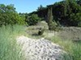
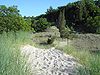
Blowouts
Blowouts are formed by the on-shore winds of Lake MichiganLake Michigan
Lake Michigan is one of the five Great Lakes of North America and the only one located entirely within the United States. It is the second largest of the Great Lakes by volume and the third largest by surface area, after Lake Superior and Lake Huron...
. The winds move sand and pile it into dunes. As the dunes form, plants begin to take hold, stabilizing the sand. Beach grasses form a large underground system of roots. This root system, creates stable areas of sand, from which the dune can grow. Slowly other plants take root in the protected areas, including bearberry (kinnikinnick) and small evergreens. Over time, larger plants like sumac, sand cherry, cottonwood, and juniper take hold and replace the grasses and smaller plants.
When a nick forms in this armor of roots and plants, the area can become a blowout. First, open sand becomes accessible to the wind. This can be by animal trails or by human footpaths. A tree could fall in a strong wind, exposing the underlying sand. When this happens, the wind once again goes to work on the loose sand. It undercuts the other roots, and begins moving sand southward. If the winds are strong enough or given enough time, a large blowout can occur, reducing the dunes to lake level over a large area. The 3 largest blowouts in the park are Beach House, Furnessville, and Big Blowout. Each extends into the interdunes, between the front rides of dunes and pockets, into the interdunal troughs. Big Blowout has uncovered an area of dead tree trunks known as the Tree Graveyard.
The park also has a Youth Tent Area separate from the public campground.