Idaho State Highway 75
Encyclopedia
State Highway 75 is a two-lane highway that travels through the Sawtooth Range
of central Idaho from Shoshone
to Challis
. The road is designated as one of Idaho's scenic byways and provides access to Sawtooth National Recreation Area
. It primarily follows the Big Wood River
and the main Salmon River
.
at an elevation
of just under 4000 feet (1219 m) above sea level. The highway heads northward, and ascends the Big Wood River
valley, into Blaine County
, past the Magic Reservoir to the west and crosses US-20 at Timmerman Junction at 4884 feet (1489 m).

 It continues northward as the Sawtooth Scenic Byway to pass through the Big Wood River communities of Bellevue
, Hailey
, and Ketchum
. Sun Valley
is accessible via a spur route
junction in Ketchum at Third Street, which becomes Sun Valley Road.
Seven miles (11 km) north of Ketchum, the highway passes by the headquarters of the Sawtooth National Recreation Area
at 6250 feet (1905 m) and the Boulder Mountains to the north, with peaks over 11,000 feet (3353 m). SH-75 climbs past the Galena Lodge to the Galena Summit
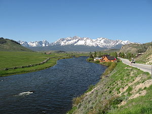
at 8701 feet (2652 m), then descends to the scenic viewpoint about a mile later, which overlooks the Sawtooth Mountains
to the west and headwaters of the Salmon River
in the Sawtooth Valley.
Highway 75 descends the grade and reaches the upper end of the valley floor at new Sawtooth City at 7190 feet (2192 m), and then enters Custer County
. It runs northward down the valley with the Salmon River to Obsidian and Stanley
, with the Sawtooths to the immediate west and the White Cloud Mountains
to the slightly more distant east. The turnoff to picturesque Redfish Lake
is about five miles (8 km) south of Stanley.
At Stanley, the highway intersects with the northern terminus of State Highway 21
, the Ponderosa Pine Scenic Byway from Boise
, through Idaho City
and Lowman
. Highway 75 becomes the Salmon River Scenic Byway, and continues north for a mile, then veers east with the twisty river towards Clayton, then north towards Challis
, where the route terminates and rejoins US-93 just south of the city limits.
 The road dates back to at least 1926 when it was designated U.S. Route 93
.
Former U.S. Route 93 Alternate, running through Arco
, was redesignated as U.S. Route 93 in 1977, and at that time this route was given its current state highway designation.
}
|3970' - 1210 m
|-
|rowspan=4 align=center|Blaine
|rowspan=2 align=center|Timmerman
Junction
|rowspan=2 align=center|102.124
|
|rowspan=2 align=center|4884' - 1489 m
|-
|
|-
| align=center|Ketchum
|128.376
|Sun Valley
Road - (3rd St)
|5850' - 1783 m
|-
|align=center|Galena Summit
|157.954
|
|8701' - 2652 m
|-
| rowspan=2 align=center|Custer
|align=center|Stanley
|189.378
|
|6250' - 1905 m
|-
|align=center|Challis
|244.325
|
|5005' - 1526 m
|}
Sawtooth Range (Idaho)
The Sawtooth Range is part of the Rocky Mountains, located within a few miles south of Stanley, Idaho, in the Western United States. Much of mountain range is within the Sawtooth Wilderness, part of the Sawtooth National Recreation Area...
of central Idaho from Shoshone
Shoshone, Idaho
Shoshone is the county seat and largest city of Lincoln County, Idaho, United States. The population was 1,398 at the 2000 census. In contrast to the Shoshone Native American tribe for which it is named, the city's name is correctly pronounced "Show-shown," with a silent 'e'.- History :Shoshone has...
to Challis
Challis, Idaho
Challis is a city in Custer County, Idaho, United States. The population was 909 at the 2000 census. The city is the county seat of Custer County.-History:...
. The road is designated as one of Idaho's scenic byways and provides access to Sawtooth National Recreation Area
Sawtooth National Recreation Area
The Sawtooth National Recreation Area is a National Recreation Area located in central Idaho, within the Boise, Challis, and Sawtooth National Forests. The recreation area is managed by the U.S. Forest Service and includes the Sawtooth Wilderness...
. It primarily follows the Big Wood River
Big Wood River
The Big Wood River is a river in central Idaho. It is a tributary of the Malad River, which in turn is tributary to the Snake River and Columbia River.-Course:...
and the main Salmon River
Salmon River (Idaho)
The Salmon River is located in Idaho in the northwestern United States. The Salmon is also known as The River of No Return. It flows for through central Idaho, draining and dropping more than between its headwaters, near Galena Summit above the Sawtooth Valley in the Sawtooth National...
.
Route description
State Highway 75 begins at a junction with US-93 on Greenwood Street in ShoshoneShoshone, Idaho
Shoshone is the county seat and largest city of Lincoln County, Idaho, United States. The population was 1,398 at the 2000 census. In contrast to the Shoshone Native American tribe for which it is named, the city's name is correctly pronounced "Show-shown," with a silent 'e'.- History :Shoshone has...
at an elevation
Elevation
The elevation of a geographic location is its height above a fixed reference point, most commonly a reference geoid, a mathematical model of the Earth's sea level as an equipotential gravitational surface ....
of just under 4000 feet (1219 m) above sea level. The highway heads northward, and ascends the Big Wood River
Big Wood River
The Big Wood River is a river in central Idaho. It is a tributary of the Malad River, which in turn is tributary to the Snake River and Columbia River.-Course:...
valley, into Blaine County
Blaine County, Idaho
Blaine County is a county located in the U.S. state of Idaho. As of the 2010 Census the county had a population of 21,376. The county seat and largest city is Hailey. The county is home to the Sun Valley ski resort....
, past the Magic Reservoir to the west and crosses US-20 at Timmerman Junction at 4884 feet (1489 m).


Bellevue, Idaho
Bellevue is a city in Blaine County in the central part of the U.S. state of Idaho. The population was 1,876 at the 2000 census. It is located in the Wood River Valley, about 18 miles south of the resort area of Ketchum and Sun Valley. The town of Hailey and the airport are a few miles north of...
, Hailey
Hailey, Idaho
Hailey is a city in and the county seat of Blaine County, in the Wood River Valley of the central part of the U.S. state of Idaho. The population was 6,200 at the 2000 census. Hailey is the site of Friedman Memorial Airport , the airport for the resort area of Sun Valley/Ketchum, north. The town...
, and Ketchum
Ketchum, Idaho
Ketchum is a city in Blaine County, Idaho, United States, in the central part of the state. The population was 3,003 at the 2000 census. It is in the Wood River Valley, adjacent to Sun Valley; the two communities share many resources and both sit in the same valley beneath Bald Mountain, with its...
. Sun Valley
Sun Valley, Idaho
Sun Valley is a resort city in Blaine County in the central part of the U.S. state of Idaho, adjacent to the city of Ketchum, lying within the greater Wood River valley. Tourists from around the world enjoy its skiing, hiking, ice skating, trail riding, tennis, and cycling. The population was 1,427...
is accessible via a spur route
Spur route
A spur route is a short road forming a branch from a longer, more important route . A bypass or beltway is never considered a true spur route as it typically reconnects with the major road...
junction in Ketchum at Third Street, which becomes Sun Valley Road.
Seven miles (11 km) north of Ketchum, the highway passes by the headquarters of the Sawtooth National Recreation Area
Sawtooth National Recreation Area
The Sawtooth National Recreation Area is a National Recreation Area located in central Idaho, within the Boise, Challis, and Sawtooth National Forests. The recreation area is managed by the U.S. Forest Service and includes the Sawtooth Wilderness...
at 6250 feet (1905 m) and the Boulder Mountains to the north, with peaks over 11,000 feet (3353 m). SH-75 climbs past the Galena Lodge to the Galena Summit
Galena Summit
Galena Summit is a high mountain pass in central Idaho, United States, at an elevation of above sea level. The pass is located in the Boulder Mountains, in the northwest corner of Blaine County, within the Sawtooth National Recreation Area of the Sawtooth National Forest.The summit is on State...
at 8701 feet (2652 m), then descends to the scenic viewpoint about a mile later, which overlooks the Sawtooth Mountains
Sawtooth Range (Idaho)
The Sawtooth Range is part of the Rocky Mountains, located within a few miles south of Stanley, Idaho, in the Western United States. Much of mountain range is within the Sawtooth Wilderness, part of the Sawtooth National Recreation Area...
to the west and headwaters of the Salmon River
Salmon River (Idaho)
The Salmon River is located in Idaho in the northwestern United States. The Salmon is also known as The River of No Return. It flows for through central Idaho, draining and dropping more than between its headwaters, near Galena Summit above the Sawtooth Valley in the Sawtooth National...
in the Sawtooth Valley.
Highway 75 descends the grade and reaches the upper end of the valley floor at new Sawtooth City at 7190 feet (2192 m), and then enters Custer County
Custer County, Idaho
Custer County is a rural mountain county located in the center of the U.S. state of Idaho. Established in 1881, it was named for the General Custer Mine, where gold was discovered five years earlier . The population was 4,342 at the 2000 census; it is estimated to have fallen to 4,166 by 2007...
. It runs northward down the valley with the Salmon River to Obsidian and Stanley
Stanley, Idaho
Stanley is a city in Custer County, Idaho, United States. The population was 100 at the 2000 census. The center of population of Idaho is located in Stanley.-Geography:...
, with the Sawtooths to the immediate west and the White Cloud Mountains
White Cloud Mountains
The White Cloud Mountains are part of the Rocky Mountainsof the western United States,located in central Idaho, southeast of Stanley in Custer County. The range is located within the Sawtooth National Recreation Area and the area that is the proposed "White Cloud - Boulder Wilderness Area." The...
to the slightly more distant east. The turnoff to picturesque Redfish Lake
Redfish Lake
Redfish Lake is an alpine lake in central Idaho, United States, located in the Sawtooth National Recreation Area, at the base of the Sawtooth Mountains in Custer County....
is about five miles (8 km) south of Stanley.
At Stanley, the highway intersects with the northern terminus of State Highway 21
Idaho State Highway 21
Idaho State Highway 21 is the Ponderosa Pine Scenic Byway, primarily a two-lane highway from Boise to Stanley. With two-thirds of its length in Boise County, it passes by historic Idaho City and the village of Lowman to the western edge of the Sawtooth Mountains, then along their northern...
, the Ponderosa Pine Scenic Byway from Boise
Boise, Idaho
Boise is the capital and most populous city of the U.S. state of Idaho, as well as the county seat of Ada County. Located on the Boise River, it anchors the Boise City-Nampa metropolitan area and is the largest city between Salt Lake City, Utah and Portland, Oregon.As of the 2010 Census Bureau,...
, through Idaho City
Idaho City, Idaho
Idaho City is a city in and the county seat of Boise County, Idaho, United States, located about northeast of Boise. The population was 458 at the 2000 census.Idaho City is part of the Boise City–Nampa, Idaho Metropolitan Statistical Area.-History:...
and Lowman
Lowman, Idaho
Lowman is a small unincorporated rural census-designated place in Boise County, Idaho, United States, nestled along the banks of the South Fork of the Payette River in the central part of the state...
. Highway 75 becomes the Salmon River Scenic Byway, and continues north for a mile, then veers east with the twisty river towards Clayton, then north towards Challis
Challis, Idaho
Challis is a city in Custer County, Idaho, United States. The population was 909 at the 2000 census. The city is the county seat of Custer County.-History:...
, where the route terminates and rejoins US-93 just south of the city limits.
History

U.S. Route 93
U.S. Route 93 is a major north–south United States highway in the western United States. The southern terminus is at U.S. Route 60 in Wickenburg, Arizona. The northern terminus is at the Canadian border north of Eureka in Lincoln County, Montana, where the roadway continues into Roosville,...
.
Former U.S. Route 93 Alternate, running through Arco
Arco, Idaho
Arco is a city in Butte County, Idaho, United States. The population was 995 at the 2010 census. The city is the county seat of Butte County.Craters of the Moon National Monument is located along U.S. Route 20, southwest of the city. The Idaho National Laboratory is located east of Arco...
, was redesignated as U.S. Route 93 in 1977, and at that time this route was given its current state highway designation.
Major intersections
| County | Location | Mile | Junction | Elevation |
|---|---|---|
| Lincoln | Shoshone Shoshone, Idaho Shoshone is the county seat and largest city of Lincoln County, Idaho, United States. The population was 1,398 at the 2000 census. In contrast to the Shoshone Native American tribe for which it is named, the city's name is correctly pronounced "Show-shown," with a silent 'e'.- History :Shoshone has... |
73.659 |
|3970' - 1210 m
|-
|rowspan=4 align=center|Blaine
Blaine County, Idaho
Blaine County is a county located in the U.S. state of Idaho. As of the 2010 Census the county had a population of 21,376. The county seat and largest city is Hailey. The county is home to the Sun Valley ski resort....
|rowspan=2 align=center|Timmerman
Junction
|rowspan=2 align=center|102.124
|
|rowspan=2 align=center|4884' - 1489 m
|-
|
|-
| align=center|Ketchum
Ketchum, Idaho
Ketchum is a city in Blaine County, Idaho, United States, in the central part of the state. The population was 3,003 at the 2000 census. It is in the Wood River Valley, adjacent to Sun Valley; the two communities share many resources and both sit in the same valley beneath Bald Mountain, with its...
|128.376
|Sun Valley
Sun Valley, Idaho
Sun Valley is a resort city in Blaine County in the central part of the U.S. state of Idaho, adjacent to the city of Ketchum, lying within the greater Wood River valley. Tourists from around the world enjoy its skiing, hiking, ice skating, trail riding, tennis, and cycling. The population was 1,427...
Road - (3rd St)
|5850' - 1783 m
|-
|align=center|Galena Summit
Galena Summit
Galena Summit is a high mountain pass in central Idaho, United States, at an elevation of above sea level. The pass is located in the Boulder Mountains, in the northwest corner of Blaine County, within the Sawtooth National Recreation Area of the Sawtooth National Forest.The summit is on State...
|157.954
|
|8701' - 2652 m
|-
| rowspan=2 align=center|Custer
Custer County, Idaho
Custer County is a rural mountain county located in the center of the U.S. state of Idaho. Established in 1881, it was named for the General Custer Mine, where gold was discovered five years earlier . The population was 4,342 at the 2000 census; it is estimated to have fallen to 4,166 by 2007...
|align=center|Stanley
Stanley, Idaho
Stanley is a city in Custer County, Idaho, United States. The population was 100 at the 2000 census. The center of population of Idaho is located in Stanley.-Geography:...
|189.378
|
|6250' - 1905 m
|-
|align=center|Challis
Challis, Idaho
Challis is a city in Custer County, Idaho, United States. The population was 909 at the 2000 census. The city is the county seat of Custer County.-History:...
|244.325
|
|5005' - 1526 m
|}
External links
- Proto Photo.com - Scenic Route 75

