
Challis, Idaho
Encyclopedia
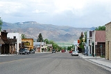
Challis is a city in Custer County
, Idaho
, United States
. The population was 909 at the 2000 census. The city is the county seat
of Custer County
.
was established in 1878.
occurred at 8:06 am MDT
, measured at 6.9 on the Richter Scale
. The Challis-Mackay region experienced rather thorough damage, with 11 commercial buildings and 39 homes with major damage; while another 200 houses were damaged, minor to moderately. Mackay
in particular, about 50 miles (80 km) southeast of Challis, experienced the most severe damage. Most of the city's large buildings on its Main Street were damaged, to some extent; eight of these buildings were deemed condemned and closed down. Most of these buildings were built from materials such as brick, concrete block, and stone, each varying.
According to the United States Census Bureau
, the city has a total area of 1.8 square miles (4.7 km²), of which, 1.8 square miles (4.7 km²) of it is land and 0.04 square mile (0.1035995244 km²) of it (1.11%) is water.
Challis experiences a semi-arid climate (Köppen climate classification
BSk) with cold winters, hot summers, and low precipitation throughout the year.
of 2000, there were 909 people, 410 households, and 248 families residing in the city. The population density
was 510.8 people per square mile (197.2/km²). There were 525 housing units at an average density of 295.0 per square mile (113.9/km²). The racial makeup of the city was 97.14% White, 0.88% Native American, 1.21% from other races
, and 0.77% from two or more races. Hispanic or Latino of any race were 3.85% of the population.
There were 410 households out of which 29.0% had children under the age of 18 living with them, 52.4% were married couples
living together, 5.1% had a female householder with no husband present, and 39.3% were non-families. 35.6% of all households were made up of individuals and 17.6% had someone living alone who was 65 years of age or older. The average household size was 2.21 and the average family size was 2.90.
In the city the population was spread out with 25.0% under the age of 18, 4.7% from 18 to 24, 26.0% from 25 to 44, 24.9% from 45 to 64, and 19.5% who were 65 years of age or older. The median age was 42 years. For every 100 females there were 98.0 males. For every 100 females age 18 and over, there were 94.3 males.
The median income for a household in the city was $29,904, and the median income for a family was $39,444. Males had a median income of $38,250 versus $21,964 for females. The per capita income
for the city was $15,803. About 8.5% of families and 12.7% of the population were below the poverty line, including 8.2% of those under age 18 and 18.5% of those age 65 or over.
Custer County, Idaho
Custer County is a rural mountain county located in the center of the U.S. state of Idaho. Established in 1881, it was named for the General Custer Mine, where gold was discovered five years earlier . The population was 4,342 at the 2000 census; it is estimated to have fallen to 4,166 by 2007...
, Idaho
Idaho
Idaho is a state in the Rocky Mountain area of the United States. The state's largest city and capital is Boise. Residents are called "Idahoans". Idaho was admitted to the Union on July 3, 1890, as the 43rd state....
, United States
United States
The United States of America is a federal constitutional republic comprising fifty states and a federal district...
. The population was 909 at the 2000 census. The city is the county seat
County seat
A county seat is an administrative center, or seat of government, for a county or civil parish. The term is primarily used in the United States....
of Custer County
Custer County, Idaho
Custer County is a rural mountain county located in the center of the U.S. state of Idaho. Established in 1881, it was named for the General Custer Mine, where gold was discovered five years earlier . The population was 4,342 at the 2000 census; it is estimated to have fallen to 4,166 by 2007...
.
History
Challis was founded in 1878 and named for A.P. Challis, who was a surveyor when the townsite was laid out. Challis post officePost office
A post office is a facility forming part of a postal system for the posting, receipt, sorting, handling, transmission or delivery of mail.Post offices offer mail-related services such as post office boxes, postage and packaging supplies...
was established in 1878.
1983 Earthquake
On Friday, October 28, 1983, the Borah Peak earthquake1983 Borah Peak earthquake
The 1983 Borah Peak earthquake occurred on October 28, 1983, in the Lost River Range at Borah Peak in central Idaho, United States. The most significant earthquake recorded in the state, it occurred on a Friday morning at 8:06 am MDT. The earthquake was a magnitude 7.3, and 6.9 on the Richter scale...
occurred at 8:06 am MDT
Mountain Time Zone
The Mountain Time Zone of North America keeps time by subtracting seven hours from Coordinated Universal Time, also known as Greenwich Mean Time, during the shortest days of autumn and winter , and by subtracting six hours during daylight saving time in the spring, summer, and early autumn...
, measured at 6.9 on the Richter Scale
Richter magnitude scale
The expression Richter magnitude scale refers to a number of ways to assign a single number to quantify the energy contained in an earthquake....
. The Challis-Mackay region experienced rather thorough damage, with 11 commercial buildings and 39 homes with major damage; while another 200 houses were damaged, minor to moderately. Mackay
Mackay, Idaho
Mackay is a city in Custer County, Idaho, United States. The population was 566 at the 2000 census.-Geography:Mackay is located at , at an elevation of 5,905 feet ....
in particular, about 50 miles (80 km) southeast of Challis, experienced the most severe damage. Most of the city's large buildings on its Main Street were damaged, to some extent; eight of these buildings were deemed condemned and closed down. Most of these buildings were built from materials such as brick, concrete block, and stone, each varying.
Geography and climate
Challis is located at 44°30′15"N 114°13′42"W (44.504260, -114.228279).According to the United States Census Bureau
United States Census Bureau
The United States Census Bureau is the government agency that is responsible for the United States Census. It also gathers other national demographic and economic data...
, the city has a total area of 1.8 square miles (4.7 km²), of which, 1.8 square miles (4.7 km²) of it is land and 0.04 square mile (0.1035995244 km²) of it (1.11%) is water.
Challis experiences a semi-arid climate (Köppen climate classification
Köppen climate classification
The Köppen climate classification is one of the most widely used climate classification systems. It was first published by Crimea German climatologist Wladimir Köppen in 1884, with several later modifications by Köppen himself, notably in 1918 and 1936...
BSk) with cold winters, hot summers, and low precipitation throughout the year.
Demographics
As of the censusCensus
A census is the procedure of systematically acquiring and recording information about the members of a given population. It is a regularly occurring and official count of a particular population. The term is used mostly in connection with national population and housing censuses; other common...
of 2000, there were 909 people, 410 households, and 248 families residing in the city. The population density
Population density
Population density is a measurement of population per unit area or unit volume. It is frequently applied to living organisms, and particularly to humans...
was 510.8 people per square mile (197.2/km²). There were 525 housing units at an average density of 295.0 per square mile (113.9/km²). The racial makeup of the city was 97.14% White, 0.88% Native American, 1.21% from other races
Race (United States Census)
Race and ethnicity in the United States Census, as defined by the Federal Office of Management and Budget and the United States Census Bureau, are self-identification data items in which residents choose the race or races with which they most closely identify, and indicate whether or not they are...
, and 0.77% from two or more races. Hispanic or Latino of any race were 3.85% of the population.
There were 410 households out of which 29.0% had children under the age of 18 living with them, 52.4% were married couples
Marriage
Marriage is a social union or legal contract between people that creates kinship. It is an institution in which interpersonal relationships, usually intimate and sexual, are acknowledged in a variety of ways, depending on the culture or subculture in which it is found...
living together, 5.1% had a female householder with no husband present, and 39.3% were non-families. 35.6% of all households were made up of individuals and 17.6% had someone living alone who was 65 years of age or older. The average household size was 2.21 and the average family size was 2.90.
In the city the population was spread out with 25.0% under the age of 18, 4.7% from 18 to 24, 26.0% from 25 to 44, 24.9% from 45 to 64, and 19.5% who were 65 years of age or older. The median age was 42 years. For every 100 females there were 98.0 males. For every 100 females age 18 and over, there were 94.3 males.
The median income for a household in the city was $29,904, and the median income for a family was $39,444. Males had a median income of $38,250 versus $21,964 for females. The per capita income
Per capita income
Per capita income or income per person is a measure of mean income within an economic aggregate, such as a country or city. It is calculated by taking a measure of all sources of income in the aggregate and dividing it by the total population...
for the city was $15,803. About 8.5% of families and 12.7% of the population were below the poverty line, including 8.2% of those under age 18 and 18.5% of those age 65 or over.