
Idaho State Highway 55
Encyclopedia
State Highway 55 is an Idaho
highway from Marsing
to New Meadows
, connecting with US-95
at both ends.
From Marsing it travels east to Nampa
, Meridian
, and Eagle
, then north to Horseshoe Bend
. SH-55 then climbs the Payette River
to Banks, then its north fork to the Long Valley
, through the towns of Cascade
and McCall
. After descending a narrow canyon to Meadows, SH-55 terminates in New Meadows
at the junction with US-95
.
 In the southwest corner of Idaho, State Highway 55 starts at the junction with US-95
, approximately 2 miles (3 km) west of Marsing
. The highway heads eastward as it travels through Marsing, crosses the Snake River
and the Snake River Valley AVA
. The highway continues east to Nampa
, where it meets Interstate 84
and US-30.
The highway is cosigned
with those routes as it heads eastward to Meridian
. Highway 55 turns northward at Eagle Road and crosses the Boise River
near Eagle
. The junction with SH-44
is in Eagle
, where the routes are briefly cosigned.
East of Eagle, Highway 55 turns northward and climbs to the Spring Valley and over the Spring Valley Summit
at 4242 feet (1293 m) (web-cam), then descends 1600 vertical feet (488 m) into Horseshoe Bend
. The new multi-lane grade was completed in the late 1980s; the old curvier road is to the west. North of Horseshoe Bend, the highway ascends the Payette River
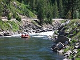
and passes through several recreational areas, which offer rafting, fishing, and camping activities.
 Highway 55 continues north, through the small communities of Banks and Smiths Ferry (web-cam), then crosses the river via the Rainbow Bridge (1933) (photo).
SH-55 then climbs Round Valley Creek to Round Valley, and continues northward through the extended Long Valley of Valley County
to the county seat
of Cascade
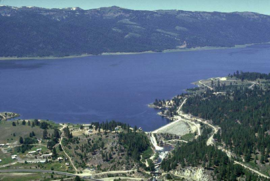
, then ascends a brief summit at 5207 feet (1587 m) at Little Donner (web-cam), then descends to follow the east shore of Cascade Reservoir
. The route continues northward to Donnelly
, the turnoff for the now-defunct Tamarack Resort
, located to the southwest, on the western shore of the reservoir. SH-55 continues north through the valley to McCall
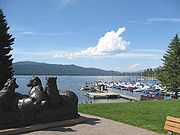
, at the south shore of Payette Lake, the host of many scenic, recreational, and winter activities.
 Meeting the south shore of Payette Lake, Highway 55 turns westward as Lake Street through McCall and its "Lardo" area. West of town, the road climbs to the Red Ridge, where it reaches its maximum elevation of 5330 feet (1625 m) above sea level, immediately northeast of the Little Ski Hill
, also known as Goose Creek Summit (web-cam). Two miles (3 km) further is the turnoff for the Brundage Mountain
ski area, four miles (6 km) north on Goose Lake Road. Highway 55 then enters a narrow and twisty canyon, rapidly descending with Little Goose Creek to Meadows, then to its northern terminus, the junction with US-95
in New Meadows
at 3868 feet (1179 m) in Meadows Valley.
Highway 55, from Eagle north to US-95 in New Meadows, is the Payette River Scenic Byway, part of the National Scenic Byways Program
.
State Highway 55 was originally routed through downtown Boise
, and followed the old alignment of State Highway 44
down State Street and 23rd St to Fairview St. From there it turned westward with US-20, US-26 and US-30. The highway continued westward on the Boise Connector then Interstate 180N (now Interstate 184), and continued west along Interstate 80N
(now Interstate 84
), where it followed its present alignment toward Nampa
.
Recently in late 2006. the route was realigned away from downtown Nampa
when a new interchange, Interchange #33 along Interstate 84
was opened and provided a more direct connection to State Highway 55 from the interstate. The segments of SH-55 following Nampa Blvd and Caldwell Blvd through Nampa
have been decommissioned favoring the more direct routing. From there the highway followed its current alignment from that point to Marsing
and its southern terminus at US-95.
Idaho
Idaho is a state in the Rocky Mountain area of the United States. The state's largest city and capital is Boise. Residents are called "Idahoans". Idaho was admitted to the Union on July 3, 1890, as the 43rd state....
highway from Marsing
Marsing, Idaho
Marsing is a city in Owyhee County, Idaho, United States. The population was 890 at the 2000 census. It is part of the Boise City–Nampa, Idaho Metropolitan Statistical Area.-Geography:Marsing is located at ....
to New Meadows
New Meadows, Idaho
New Meadows is a rural city in Adams County, Idaho, United States, at the southern and upper end of the Meadows Valley, on the Little Salmon River. Located in the west central part of the state, just south of the 45th parallel north, the population was 496 at the 2010 census. New Meadows is...
, connecting with US-95
U.S. Route 95 in Idaho
In the U.S. state of Idaho, U.S. Route 95 is a north–south highway near the western border of the state, stretching from Oregon to British Columbia for over .-Route description:...
at both ends.
From Marsing it travels east to Nampa
Nampa, Idaho
Nampa is the largest and the fastest growing city in Canyon County, Idaho, USA. The population of Nampa was 81,557 at the 2010 census. Nampa is located about west of Boise along Interstate 84, and six miles west of Meridian. Nampa is part of the Boise metropolitan area...
, Meridian
Meridian, Idaho
-History:The town was established in 1891 on the Onweiler farm north of the present site and was called Hunter. Two years later an I.O.O.F. lodge was organized and called itself Meridian because it was located on the Boise Meridian and the town was renamed...
, and Eagle
Eagle, Idaho
Eagle is a city in Ada County, Idaho, United States. The population was 19,908 at the 2010 census. Due to growth in the Boise metropolitan area, Eagle has become increasingly suburban in recent years.-Geography:...
, then north to Horseshoe Bend
Horseshoe Bend, Idaho
Horseshoe Bend is the largest city in rural Boise County, in the southwestern part of the U.S. state of Idaho. Its population of 770 at the 2000 census was the largest in the county. It is part of the Boise City–Nampa, Idaho Metropolitan Statistical Area...
. SH-55 then climbs the Payette River
Payette River
The Payette River is an river in southwestern Idaho and is a major tributary of the Snake River.Its headwaters originate in the Sawtooth and Salmon River Mountains at elevations over...
to Banks, then its north fork to the Long Valley
Valley County, Idaho
Valley County is a rural county located in west central Idaho in the United States. Established in 1917, it was named after the Long Valley of the North Fork of the Payette River, which extends over 30 miles from Payette Lake at McCall south to Cascade to Round Valley.The valley was formerly a...
, through the towns of Cascade
Cascade, Idaho
Cascade is a rural city in and the county seat of Valley County, Idaho, United States, in the west central part of the state. It sits at an elevation of , along the North Fork of the Payette River...
and McCall
McCall, Idaho
McCall is a resort town on the western edge of Valley County, Idaho, United States. Named after its founder, Tom McCall, it is situated on the southern shore of Payette Lake, near the center of the Payette National Forest...
. After descending a narrow canyon to Meadows, SH-55 terminates in New Meadows
New Meadows, Idaho
New Meadows is a rural city in Adams County, Idaho, United States, at the southern and upper end of the Meadows Valley, on the Little Salmon River. Located in the west central part of the state, just south of the 45th parallel north, the population was 496 at the 2010 census. New Meadows is...
at the junction with US-95
U.S. Route 95 in Idaho
In the U.S. state of Idaho, U.S. Route 95 is a north–south highway near the western border of the state, stretching from Oregon to British Columbia for over .-Route description:...
.
Route description
U.S. Route 95 in Idaho
In the U.S. state of Idaho, U.S. Route 95 is a north–south highway near the western border of the state, stretching from Oregon to British Columbia for over .-Route description:...
, approximately 2 miles (3 km) west of Marsing
Marsing, Idaho
Marsing is a city in Owyhee County, Idaho, United States. The population was 890 at the 2000 census. It is part of the Boise City–Nampa, Idaho Metropolitan Statistical Area.-Geography:Marsing is located at ....
. The highway heads eastward as it travels through Marsing, crosses the Snake River
Snake River
The Snake is a major river of the greater Pacific Northwest in the United States. At long, it is the largest tributary of the Columbia River, the largest North American river that empties into the Pacific Ocean...
and the Snake River Valley AVA
Snake River Valley AVA
The Snake River Valley AVA in an American Viticultural Area that encompasses an area in Southwestern Idaho and two counties in eastern Oregon. The area was designated an AVA as a result of a successful petition from the Idaho Grape Growers and Wine Producers Commission and the Idaho Department of...
. The highway continues east to Nampa
Nampa, Idaho
Nampa is the largest and the fastest growing city in Canyon County, Idaho, USA. The population of Nampa was 81,557 at the 2010 census. Nampa is located about west of Boise along Interstate 84, and six miles west of Meridian. Nampa is part of the Boise metropolitan area...
, where it meets Interstate 84
Interstate 84 in Idaho
In the U.S. state of Idaho, Interstate 84 heads southeast from the Oregon state line, it spurs to Interstate 184 in Boise. Eventually I-84 spurs Interstate 86 and mainline I-84 heads southeast towards Utah and I-86 is continues due east and heads to Pocatello, meeting with Interstate 15.-Future:...
and US-30.
The highway is cosigned
Concurrency (road)
A concurrency, overlap, or coincidence in a road network is an instance of one physical road bearing two or more different highway, motorway, or other route numbers...
with those routes as it heads eastward to Meridian
Meridian, Idaho
-History:The town was established in 1891 on the Onweiler farm north of the present site and was called Hunter. Two years later an I.O.O.F. lodge was organized and called itself Meridian because it was located on the Boise Meridian and the town was renamed...
. Highway 55 turns northward at Eagle Road and crosses the Boise River
Boise River
The Boise River is a tributary of the Snake River in the northwestern United States. It drains a rugged portion of the Sawtooth Range in southwestern Idaho northeast of Boise, as well as part of the western Snake River Plain...
near Eagle
Eagle, Idaho
Eagle is a city in Ada County, Idaho, United States. The population was 19,908 at the 2010 census. Due to growth in the Boise metropolitan area, Eagle has become increasingly suburban in recent years.-Geography:...
. The junction with SH-44
Idaho State Highway 44
State Highway 44 is a road that travels through the Treasure Valley from Interstate 84 to Garden City, Idaho.-Route description:State Highway 44 starts at the junction of Interstate 84 north of Caldwell at Exit 25. The highway heads eastward staying mostly to the north of the Boise River. The...
is in Eagle
Eagle, Idaho
Eagle is a city in Ada County, Idaho, United States. The population was 19,908 at the 2010 census. Due to growth in the Boise metropolitan area, Eagle has become increasingly suburban in recent years.-Geography:...
, where the routes are briefly cosigned.
East of Eagle, Highway 55 turns northward and climbs to the Spring Valley and over the Spring Valley Summit
Spring Valley Summit
Spring Valley Summit is a mountain pass in southwestern Idaho, United States, at an elevation of 4242 feet above sea level on State Highway 55, the Payette River Scenic Byway....
at 4242 feet (1293 m) (web-cam), then descends 1600 vertical feet (488 m) into Horseshoe Bend
Horseshoe Bend, Idaho
Horseshoe Bend is the largest city in rural Boise County, in the southwestern part of the U.S. state of Idaho. Its population of 770 at the 2000 census was the largest in the county. It is part of the Boise City–Nampa, Idaho Metropolitan Statistical Area...
. The new multi-lane grade was completed in the late 1980s; the old curvier road is to the west. North of Horseshoe Bend, the highway ascends the Payette River
Payette River
The Payette River is an river in southwestern Idaho and is a major tributary of the Snake River.Its headwaters originate in the Sawtooth and Salmon River Mountains at elevations over...
and passes through several recreational areas, which offer rafting, fishing, and camping activities.
SH-55 then climbs Round Valley Creek to Round Valley, and continues northward through the extended Long Valley of Valley County
Valley County, Idaho
Valley County is a rural county located in west central Idaho in the United States. Established in 1917, it was named after the Long Valley of the North Fork of the Payette River, which extends over 30 miles from Payette Lake at McCall south to Cascade to Round Valley.The valley was formerly a...
to the county seat
County seat
A county seat is an administrative center, or seat of government, for a county or civil parish. The term is primarily used in the United States....
of Cascade
Cascade, Idaho
Cascade is a rural city in and the county seat of Valley County, Idaho, United States, in the west central part of the state. It sits at an elevation of , along the North Fork of the Payette River...
, then ascends a brief summit at 5207 feet (1587 m) at Little Donner (web-cam), then descends to follow the east shore of Cascade Reservoir
Lake Cascade
Lake Cascade is located on the North Fork of the Payette River in Valley County, Idaho, USA, in the Boise National Forest. It is the fourth largest lake or reservoir in the state...
. The route continues northward to Donnelly
Donnelly, Idaho
Donnelly is a city in rural Valley County, Idaho, United States. The population was 138 at the 2000 census, and was estimated to be 148 in 2007....
, the turnoff for the now-defunct Tamarack Resort
Tamarack Resort
Tamarack Resort is a four-season mountain resort in the Long Valley of west central Idaho. It is located on the west shore of Cascade Reservoir, southwest of Donnelly in Valley County, about north of Boise. The resort is currently in foreclosure; the ski area was closed for the 2009-2010 season...
, located to the southwest, on the western shore of the reservoir. SH-55 continues north through the valley to McCall
McCall, Idaho
McCall is a resort town on the western edge of Valley County, Idaho, United States. Named after its founder, Tom McCall, it is situated on the southern shore of Payette Lake, near the center of the Payette National Forest...
, at the south shore of Payette Lake, the host of many scenic, recreational, and winter activities.
Little Ski Hill
The Little Ski Hill is a modest ski area in west central Idaho, two miles west of McCall. Located on Highway 55, immediately west of the county line in Adams County, it was formerly known as the "Payette Lakes Ski Area."...
, also known as Goose Creek Summit (web-cam). Two miles (3 km) further is the turnoff for the Brundage Mountain
Brundage Mountain
Brundage Mountain Resort is an alpine ski area in west central Idaho, in the Payette National Forest. Brundage first opened in November 1961 and is 8 miles northwest of McCall, a twenty minute drive in average winter conditions....
ski area, four miles (6 km) north on Goose Lake Road. Highway 55 then enters a narrow and twisty canyon, rapidly descending with Little Goose Creek to Meadows, then to its northern terminus, the junction with US-95
U.S. Route 95 in Idaho
In the U.S. state of Idaho, U.S. Route 95 is a north–south highway near the western border of the state, stretching from Oregon to British Columbia for over .-Route description:...
in New Meadows
New Meadows, Idaho
New Meadows is a rural city in Adams County, Idaho, United States, at the southern and upper end of the Meadows Valley, on the Little Salmon River. Located in the west central part of the state, just south of the 45th parallel north, the population was 496 at the 2010 census. New Meadows is...
at 3868 feet (1179 m) in Meadows Valley.
Highway 55, from Eagle north to US-95 in New Meadows, is the Payette River Scenic Byway, part of the National Scenic Byways Program
National Scenic Byway
A National Scenic Byway is a road recognized by the United States Department of Transportation for its archeological, cultural, historic, natural, recreational, and/or scenic qualities. The program was established by Congress in 1991 to preserve and protect the nation's scenic but often...
.
History
This route has been designated as State Highway 55 since 1969; and replaced former State Highway 72 and former State Highway 15State Highway 55 was originally routed through downtown Boise
Boise, Idaho
Boise is the capital and most populous city of the U.S. state of Idaho, as well as the county seat of Ada County. Located on the Boise River, it anchors the Boise City-Nampa metropolitan area and is the largest city between Salt Lake City, Utah and Portland, Oregon.As of the 2010 Census Bureau,...
, and followed the old alignment of State Highway 44
Idaho State Highway 44
State Highway 44 is a road that travels through the Treasure Valley from Interstate 84 to Garden City, Idaho.-Route description:State Highway 44 starts at the junction of Interstate 84 north of Caldwell at Exit 25. The highway heads eastward staying mostly to the north of the Boise River. The...
down State Street and 23rd St to Fairview St. From there it turned westward with US-20, US-26 and US-30. The highway continued westward on the Boise Connector then Interstate 180N (now Interstate 184), and continued west along Interstate 80N
Interstate 84 in Idaho
In the U.S. state of Idaho, Interstate 84 heads southeast from the Oregon state line, it spurs to Interstate 184 in Boise. Eventually I-84 spurs Interstate 86 and mainline I-84 heads southeast towards Utah and I-86 is continues due east and heads to Pocatello, meeting with Interstate 15.-Future:...
(now Interstate 84
Interstate 84 in Idaho
In the U.S. state of Idaho, Interstate 84 heads southeast from the Oregon state line, it spurs to Interstate 184 in Boise. Eventually I-84 spurs Interstate 86 and mainline I-84 heads southeast towards Utah and I-86 is continues due east and heads to Pocatello, meeting with Interstate 15.-Future:...
), where it followed its present alignment toward Nampa
Nampa, Idaho
Nampa is the largest and the fastest growing city in Canyon County, Idaho, USA. The population of Nampa was 81,557 at the 2010 census. Nampa is located about west of Boise along Interstate 84, and six miles west of Meridian. Nampa is part of the Boise metropolitan area...
.
Recently in late 2006. the route was realigned away from downtown Nampa
Nampa, Idaho
Nampa is the largest and the fastest growing city in Canyon County, Idaho, USA. The population of Nampa was 81,557 at the 2010 census. Nampa is located about west of Boise along Interstate 84, and six miles west of Meridian. Nampa is part of the Boise metropolitan area...
when a new interchange, Interchange #33 along Interstate 84
Interstate 84 in Idaho
In the U.S. state of Idaho, Interstate 84 heads southeast from the Oregon state line, it spurs to Interstate 184 in Boise. Eventually I-84 spurs Interstate 86 and mainline I-84 heads southeast towards Utah and I-86 is continues due east and heads to Pocatello, meeting with Interstate 15.-Future:...
was opened and provided a more direct connection to State Highway 55 from the interstate. The segments of SH-55 following Nampa Blvd and Caldwell Blvd through Nampa
Nampa, Idaho
Nampa is the largest and the fastest growing city in Canyon County, Idaho, USA. The population of Nampa was 81,557 at the 2010 census. Nampa is located about west of Boise along Interstate 84, and six miles west of Meridian. Nampa is part of the Boise metropolitan area...
have been decommissioned favoring the more direct routing. From there the highway followed its current alignment from that point to Marsing
Marsing, Idaho
Marsing is a city in Owyhee County, Idaho, United States. The population was 890 at the 2000 census. It is part of the Boise City–Nampa, Idaho Metropolitan Statistical Area.-Geography:Marsing is located at ....
and its southern terminus at US-95.
Major intersections
| County | Location | Mile | Destinations | Notes |
|---|---|---|---|---|
| Owyhee | 0.00 | , Winnemucca Winnemucca, Nevada -Demographics:As of the census of 2000, there were 7,174 people, 2,736 households, and 1,824 families residing in the city. The population density was 867.5 people per square mile . There were 3,280 housing units at an average density of 396.6 per square mile... |
||
| Marsing | 2.00 | |||
| Canyon | Nampa | 16.15 | BUSINESS ROUTE I-84 | |
| 16.60 | Interchange, Begin Cosigning with I-84 | |||
| Ada | Meridian | 29.06 | Interchange, End of Cosigning with I-84 | |
| 33.92 | ||||
| Eagle | 35.83 | |||
| Eagle | 37.79 | |||
| Boise | Horseshoe Bend | 57.30 | ||
| Adams | New Meadows | 148.70 |
External links
- Payette River Scenic Byway - Corridor Plan - Idaho Transportation Dept.
- Idaho Transportation Dept. - photo - Rainbow Bridge (opened 1933)
- Idaho Transportation Dept. - roadcams - State Highway 55