
.gif)
Hurricane Lester (1998)
Encyclopedia
Hurricane Lester was the fifteenth tropical cyclone
, twelfth named storm and eighth hurricane of the 1998 Pacific hurricane season
. Lester originated from a tropical wave
that emerged off the coast of Africa
on September 29. Under favorable conditions, the storm was classified as a tropical depression on October 15. The depression was upgraded to a tropical storm later that day and a hurricane on October 16. After undergoing fluctuations in intensity, Lester reached peak winds of 115 mph (185.1 km/h), a Category 3 hurricane on the Saffir-Simpson Hurricane Scale
. After several days, it degenerated into a tropical storm on October 26, and dissipated shortly after. The hurricane made its closest approach to land on October 18, producing moderate winds and heavy rainfall. A mudslide triggered by the precipitation killed two children, although damage is unknown.
moved off the coast of Africa
on September 29, 1998 and on October 5, an area of convection along the wave developed into Atlantic Hurricane Lisa
. The wave axis continued westward, and after crossing Central America
a low-level circulation developed on October 13, about 170 miles (275 km) south of the border between El Salvador
and Guatemala
. The system drifted northwestward, and as convection increased around the center a banding featured began to develop. At 0000 UTC on October 15, the National Hurricane Center
designated it as Tropical Depression Fourteen-E. The depression contained a large envelope of convective activity, and under favorable conditions including warm water, low vertical wind shear and good outflow, it gradually began to intensify. Initially, the exact direction of forward movement was somewhat uncertain, although a northwestward track was predicted. On the morning of October 15, visible satellite imagery suggested that the center of circulation was located northeast of the previous estimates. Thunderstorm activity organized close to the center by 1400 UTC, and by 1800 UTC the depression was upgraded to Tropical Storm Lester.
Shortly thereafter, the storm took a slight jog to the west, and at the same time outflow became restricted to the southwest of the circulation. At 1400 UTC on October 16, data from a Reconnaissance Aircraft confirmed that the storm had attained hurricane intensity with a minimum central pressure of 992 mb. The first signs of an eye
began to appear embedded within a ring of deep convection by early on October 17, while moving west-northwest at about 6 mph (9.7 km/h). Shortly after, the hurricane became nearly stationary due to a shortwave which passed north of the system, shortly before reaching Category 2
status on the Saffir-Simpson Hurricane Scale. Early on October 18, the eye began to wobble slightly and the ring of cold cloud tops were showing signs of disorganization, slowing further intensification for several hours. At 1400 UTC, Lester's winds increased to 100 mph (160.9 km/h) and the storm made its closest approach to land on October 18, about 70 miles (110 km) south of Puerto Angel, Oaxaca. Later that day, it weakened to Category 1 status, although quickly re-intensified.
Vertical wind shear
associated with a mid-to-upper-level low pressure system developed and began to affect the storm's circulation on October 19, thus weakening it slightly. However, early on October 20 the hurricane regained organization and once again intensified. Lester strengthened to reach a peak intensity of 115 mph (185 km/h) on October 22, about 355 miles (570 km) southwest of Manzanillo, Colima
. Coinciding with its peak intensity, a short-wave trough
caused Lester to stall before turning to the southwest and weakening. At 0200 UTC on October 23 Lester rapidly lost deep convection, and weakened to Category 1 status. Later that morning, the storm was downgraded to a tropical storm while tracking southwest. By October 24, the low-level center of circulation became exposed from the cloud structure, and at 0000 UTC on October 16, Lester had degenerated into a tropical depression, about 500 miles (805 km) southwest of the southern tip of Baja California Peninsula
, shortly before dissipating.
 In anticipation of the storm, the government of Mexico
issued a hurricane warning
from Puerto Arista to Punta Maldonaldo and later from Salina Cruz
to Acapulco
. A tropical storm warning was also issued from Sipacate
, Guatemala to Puerto Arista, Mexico. The threat of the hurricane prompted officials to order the evacuation of 3,000 people along the southern coast of Mexico to 500 emergency shelters.
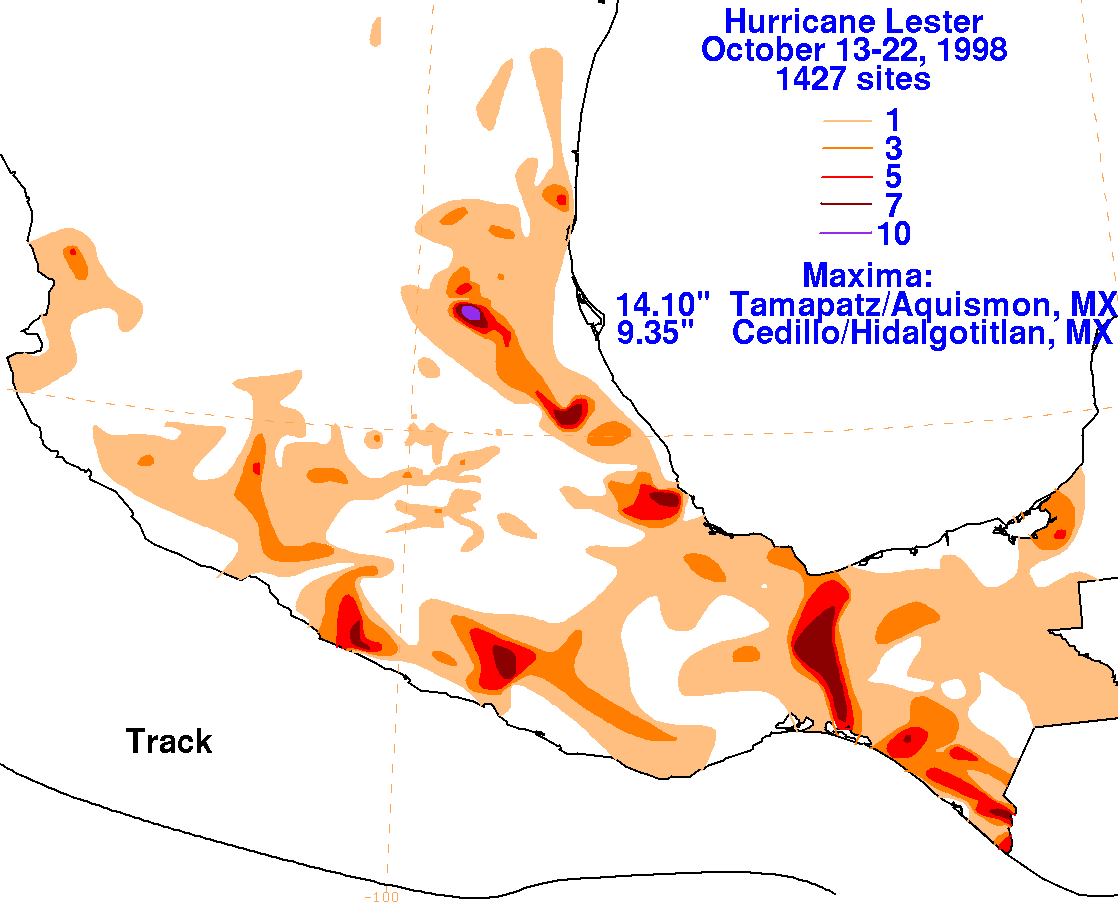
The storm dropped heavy rainfall across southwestern Guatemala
. Up to 9 inches (228 mm) of rainfall was reported in localized areas along the Pacific coast of the country. Moisture brought around the northeast periphery of the Sierra Madre Occidental
led to a narrow band of heavy rainfall along the upslope side of the mountain range, with a local precipitation maximum exceeding 14 inches (360 mm). It is reported that tropical-storm-force winds occurred along coastal areas of southern Mexico. The rainfall destroyed some houses and killed numerous livestock, and triggered a mudslide which killed two children. In Honduras
, rainfall from the Lester destroyed a bridge which affected transportation for about 1,000 people. Heavy rainfall was reported in Chiapas
, causing moderate river flooding though no reported damage.
Tropical cyclone
A tropical cyclone is a storm system characterized by a large low-pressure center and numerous thunderstorms that produce strong winds and heavy rain. Tropical cyclones strengthen when water evaporated from the ocean is released as the saturated air rises, resulting in condensation of water vapor...
, twelfth named storm and eighth hurricane of the 1998 Pacific hurricane season
1998 Pacific hurricane season
The 1998 Pacific hurricane season was a moderately active Pacific hurricane season with seven tropical cyclones directly affecting land. The season officially started on May 15 in the eastern Pacific, and on June 1 in the central Pacific, and ended on November 30; these dates conventionally delimit...
. Lester originated from a tropical wave
Tropical wave
Tropical waves, easterly waves, or tropical easterly waves, also known as African easterly waves in the Atlantic region, are a type of atmospheric trough, an elongated area of relatively low air pressure, oriented north to south, which move from east to west across the tropics causing areas of...
that emerged off the coast of Africa
Africa
Africa is the world's second largest and second most populous continent, after Asia. At about 30.2 million km² including adjacent islands, it covers 6% of the Earth's total surface area and 20.4% of the total land area...
on September 29. Under favorable conditions, the storm was classified as a tropical depression on October 15. The depression was upgraded to a tropical storm later that day and a hurricane on October 16. After undergoing fluctuations in intensity, Lester reached peak winds of 115 mph (185.1 km/h), a Category 3 hurricane on the Saffir-Simpson Hurricane Scale
Saffir-Simpson Hurricane Scale
The Saffir–Simpson Hurricane Scale , or the Saffir–Simpson Hurricane Wind Scale , classifies hurricanes — Western Hemisphere tropical cyclones that exceed the intensities of tropical depressions and tropical storms — into five categories distinguished by the intensities of their sustained winds...
. After several days, it degenerated into a tropical storm on October 26, and dissipated shortly after. The hurricane made its closest approach to land on October 18, producing moderate winds and heavy rainfall. A mudslide triggered by the precipitation killed two children, although damage is unknown.
Meteorological history
A tropical waveTropical wave
Tropical waves, easterly waves, or tropical easterly waves, also known as African easterly waves in the Atlantic region, are a type of atmospheric trough, an elongated area of relatively low air pressure, oriented north to south, which move from east to west across the tropics causing areas of...
moved off the coast of Africa
Africa
Africa is the world's second largest and second most populous continent, after Asia. At about 30.2 million km² including adjacent islands, it covers 6% of the Earth's total surface area and 20.4% of the total land area...
on September 29, 1998 and on October 5, an area of convection along the wave developed into Atlantic Hurricane Lisa
Hurricane Lisa (1998)
Hurricane Lisa was the 12th known tropical cyclone of the 1998 Atlantic hurricane season. The storm developed from a tropical wave that entered the Atlantic Ocean on September 29 from the coast of Africa. By October 4, a low-level circulation developed, and the system was declared a tropical...
. The wave axis continued westward, and after crossing Central America
Central America
Central America is the central geographic region of the Americas. It is the southernmost, isthmian portion of the North American continent, which connects with South America on the southeast. When considered part of the unified continental model, it is considered a subcontinent...
a low-level circulation developed on October 13, about 170 miles (275 km) south of the border between El Salvador
El Salvador
El Salvador or simply Salvador is the smallest and the most densely populated country in Central America. The country's capital city and largest city is San Salvador; Santa Ana and San Miguel are also important cultural and commercial centers in the country and in all of Central America...
and Guatemala
Guatemala
Guatemala is a country in Central America bordered by Mexico to the north and west, the Pacific Ocean to the southwest, Belize to the northeast, the Caribbean to the east, and Honduras and El Salvador to the southeast...
. The system drifted northwestward, and as convection increased around the center a banding featured began to develop. At 0000 UTC on October 15, the National Hurricane Center
National Hurricane Center
The National Hurricane Center , located at Florida International University in Miami, Florida, is the division of the National Weather Service responsible for tracking and predicting weather systems within the tropics between the Prime Meridian and the 140th meridian west poleward to the 30th...
designated it as Tropical Depression Fourteen-E. The depression contained a large envelope of convective activity, and under favorable conditions including warm water, low vertical wind shear and good outflow, it gradually began to intensify. Initially, the exact direction of forward movement was somewhat uncertain, although a northwestward track was predicted. On the morning of October 15, visible satellite imagery suggested that the center of circulation was located northeast of the previous estimates. Thunderstorm activity organized close to the center by 1400 UTC, and by 1800 UTC the depression was upgraded to Tropical Storm Lester.
Shortly thereafter, the storm took a slight jog to the west, and at the same time outflow became restricted to the southwest of the circulation. At 1400 UTC on October 16, data from a Reconnaissance Aircraft confirmed that the storm had attained hurricane intensity with a minimum central pressure of 992 mb. The first signs of an eye
Eye (cyclone)
The eye is a region of mostly calm weather found at the center of strong tropical cyclones. The eye of a storm is a roughly circular area and typically 30–65 km in diameter. It is surrounded by the eyewall, a ring of towering thunderstorms where the second most severe weather of a cyclone...
began to appear embedded within a ring of deep convection by early on October 17, while moving west-northwest at about 6 mph (9.7 km/h). Shortly after, the hurricane became nearly stationary due to a shortwave which passed north of the system, shortly before reaching Category 2
Saffir-Simpson Hurricane Scale
The Saffir–Simpson Hurricane Scale , or the Saffir–Simpson Hurricane Wind Scale , classifies hurricanes — Western Hemisphere tropical cyclones that exceed the intensities of tropical depressions and tropical storms — into five categories distinguished by the intensities of their sustained winds...
status on the Saffir-Simpson Hurricane Scale. Early on October 18, the eye began to wobble slightly and the ring of cold cloud tops were showing signs of disorganization, slowing further intensification for several hours. At 1400 UTC, Lester's winds increased to 100 mph (160.9 km/h) and the storm made its closest approach to land on October 18, about 70 miles (110 km) south of Puerto Angel, Oaxaca. Later that day, it weakened to Category 1 status, although quickly re-intensified.
Vertical wind shear
Wind shear
Wind shear, sometimes referred to as windshear or wind gradient, is a difference in wind speed and direction over a relatively short distance in the atmosphere...
associated with a mid-to-upper-level low pressure system developed and began to affect the storm's circulation on October 19, thus weakening it slightly. However, early on October 20 the hurricane regained organization and once again intensified. Lester strengthened to reach a peak intensity of 115 mph (185 km/h) on October 22, about 355 miles (570 km) southwest of Manzanillo, Colima
Manzanillo, Colima
The name Manzanillo refers to the city as well as its surrounding municipality in the Mexican state of Colima. The city, located on the Pacific Ocean, contains Mexico's busiest port. Manzanillo was the third port created by the Spanish in the Pacific during the New Spain period...
. Coinciding with its peak intensity, a short-wave trough
Trough (meteorology)
A trough is an elongated region of relatively low atmospheric pressure, often associated with fronts.Unlike fronts, there is not a universal symbol for a trough on a weather chart. The weather charts in some countries or regions mark troughs by a line. In the United States, a trough may be marked...
caused Lester to stall before turning to the southwest and weakening. At 0200 UTC on October 23 Lester rapidly lost deep convection, and weakened to Category 1 status. Later that morning, the storm was downgraded to a tropical storm while tracking southwest. By October 24, the low-level center of circulation became exposed from the cloud structure, and at 0000 UTC on October 16, Lester had degenerated into a tropical depression, about 500 miles (805 km) southwest of the southern tip of Baja California Peninsula
Baja California Peninsula
The Baja California peninsula , is a peninsula in northwestern Mexico. Its land mass separates the Pacific Ocean from the Gulf of California. The Peninsula extends from Mexicali, Baja California in the north to Cabo San Lucas, Baja California Sur in the south.The total area of the Baja California...
, shortly before dissipating.
Preparations and impact
Mexico
The United Mexican States , commonly known as Mexico , is a federal constitutional republic in North America. It is bordered on the north by the United States; on the south and west by the Pacific Ocean; on the southeast by Guatemala, Belize, and the Caribbean Sea; and on the east by the Gulf of...
issued a hurricane warning
Tropical cyclone warnings and watches
Warnings and watches are two levels of alert issued by national weather forecasting bodies to coastal areas threatened by the imminent approach of a tropical cyclone of tropical storm or hurricane intensity. They are notices to the local population and civil authorities to make appropriate...
from Puerto Arista to Punta Maldonaldo and later from Salina Cruz
Salina Cruz
Salina Cruz is a major seaport on the Pacific coast of the Mexican state of Oaxaca. It is the state's third-largest city and is municipal seat of the municipality of the same name.It is part of the Tehuantepec District in the west of the Istmo Region....
to Acapulco
Acapulco
Acapulco is a city, municipality and major sea port in the state of Guerrero on the Pacific coast of Mexico, southwest from Mexico City. Acapulco is located on a deep, semi-circular bay and has been a port since the early colonial period of Mexico’s history...
. A tropical storm warning was also issued from Sipacate
Sipacate
Sipacate is a resort town on the Pacific coast of Guatemala, in Escuintla Department about 22 miles west of Puerto San José. It is promoted as a venue for surfing. Being roughly in the center of the Guatemalan coastline, it is used as a breakpoint for storm warnings...
, Guatemala to Puerto Arista, Mexico. The threat of the hurricane prompted officials to order the evacuation of 3,000 people along the southern coast of Mexico to 500 emergency shelters.
The storm dropped heavy rainfall across southwestern Guatemala
Guatemala
Guatemala is a country in Central America bordered by Mexico to the north and west, the Pacific Ocean to the southwest, Belize to the northeast, the Caribbean to the east, and Honduras and El Salvador to the southeast...
. Up to 9 inches (228 mm) of rainfall was reported in localized areas along the Pacific coast of the country. Moisture brought around the northeast periphery of the Sierra Madre Occidental
Sierra Madre Occidental
The Sierra Madre Occidental is a mountain range in western Mexico.-Setting:The range runs north to south, from just south of the Sonora–Arizona border southeast through eastern Sonora, western Chihuahua, Sinaloa, Durango, Zacatecas, Nayarit, Jalisco, Aguascalientes to Guanajuato, where it joins...
led to a narrow band of heavy rainfall along the upslope side of the mountain range, with a local precipitation maximum exceeding 14 inches (360 mm). It is reported that tropical-storm-force winds occurred along coastal areas of southern Mexico. The rainfall destroyed some houses and killed numerous livestock, and triggered a mudslide which killed two children. In Honduras
Honduras
Honduras is a republic in Central America. It was previously known as Spanish Honduras to differentiate it from British Honduras, which became the modern-day state of Belize...
, rainfall from the Lester destroyed a bridge which affected transportation for about 1,000 people. Heavy rainfall was reported in Chiapas
Chiapas
Chiapas officially Estado Libre y Soberano de Chiapas is one of the 31 states that, with the Federal District, comprise the 32 Federal Entities of Mexico. It is divided in 118 municipalities and its capital city is Tuxtla Gutierrez. Other important cites in Chiapas include San Cristóbal de las...
, causing moderate river flooding though no reported damage.
See also
- Other tropical cyclones name Lester
- List of Pacific hurricanes