
.gif)
Hurricane Kristy (2006)
Encyclopedia
Hurricane Kristy in 2006 was a relatively long-lived tropical cyclone
in the 2006 Pacific hurricane season
. It developed on August 30 from a tropical wave
off the southwest coast of Mexico, and quickly intensified to attain hurricane status, reaching peak winds of 80 mph (130 km/h). Subsequently, Kristy weakened from cooler waters and increased wind shear
from Hurricane John
to its northeast. Steering currents weakened, and turning to a southerly drift, it weakened to a tropical depression by September 2. The next day it briefly regained tropical storm status, only to again deteriorate to depression status. After turning to the west, Kristy encountered marginally favorable conditions and attained tropical storm status for a third time, though unfavorable conditions caused it to dissipate on September 9. The storm never affected land, although initially there was a slight threat to Clarion Island
. Within the National Hurricane Center
area of warning responsibility east of 140ºW, Hurricane Kristy was the longest-lasting tropical cyclone of the season.
moved off the west coast of Africa on August 13. With a large swirl of low clouds and little convection, the system tracked westward for two weeks across the Atlantic Ocean and Caribbean Sea, before crossing Central America on August 22. On August 29, the system became better organized, consisting of a broad low pressure area
and thunderstorm activity. The convection persisted and organized further, and at 0000 UTC
on August 30 it developed into Tropical Depression Twelve-E about 600 mi (970 km) southwest of the southern tip of the Baja California peninsula.
Upon becoming a tropical cyclone, the depression was experiencing slight easterly wind shear
, which distorted the convection to the west of the circulation. However, favorable conditions for strengthening were expected, and the depression was forecast to reach peak winds of 50 mph (85 km/h) before weakening. It tracked slowly northwestward along the southern periphery of a ridge
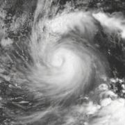
, and quickly intensified into Tropical Storm Kristy after convection increased over its circulation center. By that time, wind shear had decreased to very low levels, and with very warm waters, the storm was expected to quickly intensify to reach hurricane status. By late on August 30, the convection was wrapping into the center while an eye feature
became intermittent. Organization continued, and Kristy attained hurricane status early on August 31, about 30 hours after forming. Six hours after attaining hurricane status, an eye-like featured was evident on satellite imagery, and it is estimated Kristy attained peak winds of 80 mph (130 km/h) about 550 mi (880 km) southwest of the southern tip of the Baja California. However, satellite-derived intensity estimates suggested the hurricane could have been as strong as 105 mph (170 km/h), or as weak as a tropical storm.
of powerful Hurricane John
to its east. Additionally, the hurricane moved into an area of cooler water temperatures, and as a result its appearance became ragged and amorphous. At the same time, steering currents weakened, and the future of Kristy was uncertain; the NHC forecast the hurricane to continue slowly westward, dissipating within four days. However, other hurricane models suggested a motion to the southwest, and two models predicted a Fujiwhara effect
, or an orbiting of two tropical cyclones, which would eventually result in Kristy being absorbed by Hurricane John. On September 1, Kristy weakened to tropical storm status, and it weakened faster as dry air encroached the storm. It turned southeastward as the ridge to its north strengthened. On September 2, the circulation became exposed from the convection, and it was forecast to degenerate into a remnant low within 24 hours. Later that day, Kristy weakened to tropical depression status.
 By September 3, Tropical Depression Kristy was without persistent deep convection for about 18 hours. However, thunderstorms increased around the center later that day, developing a shallow eye-like feature. The convection persisted along the western periphery of the circulation, and it is estimated Kristy re-attained tropical storm status about 24 hours after it was first downgraded to depression status. Around the same time, the cyclone began a steady motion to the southwest. Its re-intensification was short-lived, as continued wind shear weakened the convection and left the center devoid of any thunderstorms. On September 4, Kristy weakened to tropical depression status, and though quick dissipation was predicted, officials noted that intermittent convection flares could develop. One such convection flare occurred on September 5, which persisted around the center and warranted Kristy being upgraded to tropical storm status. By that time, wind shear had decreased somewhat and the storm had turned westward, and with a track through warm water temperatures, Kristy was forecast to maintain tropical storm status for five days.
At one point as a tropical storm, the thunderstorm activity around Kristy appeared to be organizing into hooking bands, and further intensification was considered likely, potentially as strong as 60 mph (95 km/h). However, the thunderstorm activity decreased markedly on September 6, primarily from dry air entrainment, and it weakened to tropical depression status for the last time. In one forecast, Kristy was predicted to move into the area of warning responsibility of the Central Pacific Hurricane Center
, or west of 140ºW
. However, the depression was unable to maintain organized convection around its center for a few days, and Kristy degenerated into a remnant low on September 8. The low turned to the southwest, degenerating into a tropical wave on September 9 about 1500 miles (2400 km) southeast of the island of Hawaii
, or about 1600 miles (2600 km) southwest of the southern tip of the Baja California peninsula. The remnant disturbance continued westward, and initially Kristy was believed to have developed into Tropical Depression Two-C in the central Pacific Ocean; however, post-season analysis concluded the systems were separate.
Tropical cyclone
A tropical cyclone is a storm system characterized by a large low-pressure center and numerous thunderstorms that produce strong winds and heavy rain. Tropical cyclones strengthen when water evaporated from the ocean is released as the saturated air rises, resulting in condensation of water vapor...
in the 2006 Pacific hurricane season
2006 Pacific hurricane season
The 2006 Pacific hurricane season was the most active Pacific hurricane season since 2000 producing 19 tropical storms or hurricanes. Eighteen developed within the National Hurricane Center area of warning responsibility, which is east of 140ºW, and one storm formed between 140ºW and the...
. It developed on August 30 from a tropical wave
Tropical wave
Tropical waves, easterly waves, or tropical easterly waves, also known as African easterly waves in the Atlantic region, are a type of atmospheric trough, an elongated area of relatively low air pressure, oriented north to south, which move from east to west across the tropics causing areas of...
off the southwest coast of Mexico, and quickly intensified to attain hurricane status, reaching peak winds of 80 mph (130 km/h). Subsequently, Kristy weakened from cooler waters and increased wind shear
Wind shear
Wind shear, sometimes referred to as windshear or wind gradient, is a difference in wind speed and direction over a relatively short distance in the atmosphere...
from Hurricane John
Hurricane John (2006)
Hurricane John was the eleventh named storm, seventh hurricane, and fifth major hurricane of the 2006 Pacific hurricane season. Hurricane John developed on August 28 from a tropical wave to the south of Mexico. Favorable conditions allowed the storm to intensify quickly, and it attained peak winds...
to its northeast. Steering currents weakened, and turning to a southerly drift, it weakened to a tropical depression by September 2. The next day it briefly regained tropical storm status, only to again deteriorate to depression status. After turning to the west, Kristy encountered marginally favorable conditions and attained tropical storm status for a third time, though unfavorable conditions caused it to dissipate on September 9. The storm never affected land, although initially there was a slight threat to Clarion Island
Clarion Island
Isla Clarión, formerly called Santa Rosa, is the second largest, westernmost and most remote of the Revillagigedo Islands, west of Socorro Island and over from the Mexican mainland and an area ². It has three prominent peaks. The westernmost and tallest peak, Monte Gallegos, is high...
. Within the National Hurricane Center
National Hurricane Center
The National Hurricane Center , located at Florida International University in Miami, Florida, is the division of the National Weather Service responsible for tracking and predicting weather systems within the tropics between the Prime Meridian and the 140th meridian west poleward to the 30th...
area of warning responsibility east of 140ºW, Hurricane Kristy was the longest-lasting tropical cyclone of the season.
Genesis
A tropical waveTropical wave
Tropical waves, easterly waves, or tropical easterly waves, also known as African easterly waves in the Atlantic region, are a type of atmospheric trough, an elongated area of relatively low air pressure, oriented north to south, which move from east to west across the tropics causing areas of...
moved off the west coast of Africa on August 13. With a large swirl of low clouds and little convection, the system tracked westward for two weeks across the Atlantic Ocean and Caribbean Sea, before crossing Central America on August 22. On August 29, the system became better organized, consisting of a broad low pressure area
Low pressure area
A low-pressure area, or "low", is a region where the atmospheric pressure at sea level is below that of surrounding locations. Low-pressure systems form under areas of wind divergence which occur in upper levels of the troposphere. The formation process of a low-pressure area is known as...
and thunderstorm activity. The convection persisted and organized further, and at 0000 UTC
Coordinated Universal Time
Coordinated Universal Time is the primary time standard by which the world regulates clocks and time. It is one of several closely related successors to Greenwich Mean Time. Computer servers, online services and other entities that rely on having a universally accepted time use UTC for that purpose...
on August 30 it developed into Tropical Depression Twelve-E about 600 mi (970 km) southwest of the southern tip of the Baja California peninsula.
Upon becoming a tropical cyclone, the depression was experiencing slight easterly wind shear
Wind shear
Wind shear, sometimes referred to as windshear or wind gradient, is a difference in wind speed and direction over a relatively short distance in the atmosphere...
, which distorted the convection to the west of the circulation. However, favorable conditions for strengthening were expected, and the depression was forecast to reach peak winds of 50 mph (85 km/h) before weakening. It tracked slowly northwestward along the southern periphery of a ridge
Ridge (meteorology)
A ridge is an elongated region of relatively high atmospheric pressure, the opposite of a trough....
, and quickly intensified into Tropical Storm Kristy after convection increased over its circulation center. By that time, wind shear had decreased to very low levels, and with very warm waters, the storm was expected to quickly intensify to reach hurricane status. By late on August 30, the convection was wrapping into the center while an eye feature
Eye (cyclone)
The eye is a region of mostly calm weather found at the center of strong tropical cyclones. The eye of a storm is a roughly circular area and typically 30–65 km in diameter. It is surrounded by the eyewall, a ring of towering thunderstorms where the second most severe weather of a cyclone...
became intermittent. Organization continued, and Kristy attained hurricane status early on August 31, about 30 hours after forming. Six hours after attaining hurricane status, an eye-like featured was evident on satellite imagery, and it is estimated Kristy attained peak winds of 80 mph (130 km/h) about 550 mi (880 km) southwest of the southern tip of the Baja California. However, satellite-derived intensity estimates suggested the hurricane could have been as strong as 105 mph (170 km/h), or as weak as a tropical storm.
Weakening and demise
Subsequently, wind shear increased, caused by the outflowOutflow (meteorology)
Outflow, in meteorology, is air that flows outwards from a storm system. It is associated with ridging, or anticyclonic flow. In the low levels of the troposphere, outflow radiates from thunderstorms in the form of a wedge of rain-cooled air, which is visible as a thin rope-like cloud on weather...
of powerful Hurricane John
Hurricane John (2006)
Hurricane John was the eleventh named storm, seventh hurricane, and fifth major hurricane of the 2006 Pacific hurricane season. Hurricane John developed on August 28 from a tropical wave to the south of Mexico. Favorable conditions allowed the storm to intensify quickly, and it attained peak winds...
to its east. Additionally, the hurricane moved into an area of cooler water temperatures, and as a result its appearance became ragged and amorphous. At the same time, steering currents weakened, and the future of Kristy was uncertain; the NHC forecast the hurricane to continue slowly westward, dissipating within four days. However, other hurricane models suggested a motion to the southwest, and two models predicted a Fujiwhara effect
Fujiwhara effect
The Fujiwhara effect or Fujiwara interaction, named after Sakuhei Fujiwhara, is a type of interaction between two nearby cyclonic vortices, causing them to appear to "orbit" each other.-Description:...
, or an orbiting of two tropical cyclones, which would eventually result in Kristy being absorbed by Hurricane John. On September 1, Kristy weakened to tropical storm status, and it weakened faster as dry air encroached the storm. It turned southeastward as the ridge to its north strengthened. On September 2, the circulation became exposed from the convection, and it was forecast to degenerate into a remnant low within 24 hours. Later that day, Kristy weakened to tropical depression status.
At one point as a tropical storm, the thunderstorm activity around Kristy appeared to be organizing into hooking bands, and further intensification was considered likely, potentially as strong as 60 mph (95 km/h). However, the thunderstorm activity decreased markedly on September 6, primarily from dry air entrainment, and it weakened to tropical depression status for the last time. In one forecast, Kristy was predicted to move into the area of warning responsibility of the Central Pacific Hurricane Center
Central Pacific Hurricane Center
The Central Pacific Hurricane Center of the United States National Weather Service is the official body responsible for tracking and issuing tropical cyclone warnings, watches, advisories, discussions, and statements for the Central North Pacific Basin...
, or west of 140ºW
Longitude
Longitude is a geographic coordinate that specifies the east-west position of a point on the Earth's surface. It is an angular measurement, usually expressed in degrees, minutes and seconds, and denoted by the Greek letter lambda ....
. However, the depression was unable to maintain organized convection around its center for a few days, and Kristy degenerated into a remnant low on September 8. The low turned to the southwest, degenerating into a tropical wave on September 9 about 1500 miles (2400 km) southeast of the island of Hawaii
Hawaii (island)
The Island of Hawaii, also called the Big Island or Hawaii Island , is a volcanic island in the North Pacific Ocean...
, or about 1600 miles (2600 km) southwest of the southern tip of the Baja California peninsula. The remnant disturbance continued westward, and initially Kristy was believed to have developed into Tropical Depression Two-C in the central Pacific Ocean; however, post-season analysis concluded the systems were separate.
See also
- Other tropical cyclones named Kristy
- List of Pacific hurricanes
- Timeline of the 2006 Pacific hurricane seasonTimeline of the 2006 Pacific hurricane seasonThe 2006 Pacific hurricane season was the most active since the 2000 season, producing produced 21 tropical depressions; 19 of which became tropical storms or hurricanes...
- List of storms in the 2006 Pacific hurricane season