
.gif)
Hurricane Klaus (1984)
Encyclopedia
Hurricane Klaus was an Atlantic hurricane
that hit the Leeward Islands
from the west in November of the 1984 Atlantic hurricane season
. Forming from a broad area of low pressure on November 5, Klaus maintained a northeast movement throughout much of its path. After making landfall on extreme eastern Puerto Rico
, it passed to the north of the Leeward Islands
, resulting in strong southwesterly winds and rough seas. Klaus attained hurricane status and reached peak winds of 90 mph (145 km/h) before becoming extratropical over cooler waters on November 13. The storm dropped heavy rainfall in Puerto Rico, causing minor flooding and light damage. Klaus caused heavy marine damage in the Leeward Islands, including wrecking at least three ships. The Virgin Islands experienced heavy damage as well.
on November 1. It moved slowly westward and steadily organized. By November 4, the system stalled to the north of Curaçao
, which was followed by a turn to the northeast. Convection slowly organized as a surface circulation formed, and on November 5 the system developed into Tropical Depression Fifteen. Initially weak with only 20 mph (32 km/h) winds, the depression steadily organized as it moved northeastward, and a Reconnaissance Aircraft
mission confirmed the existence of the cyclone on November 6 as it was located midway between Puerto Rico
and the Netherlands Antilles
. Late on the 6th, the depression strengthened into Tropical Storm Klaus while located a short distance south of Puerto Rico
.
Tropical Storm Klaus continued northeastward, and made landfall on extreme eastern Puerto Rico early on November 7. The storm passed a short distance north of the Lesser Antilles
, and became the first tropical cyclone in recorded history to affect the islands from the west. Favorable conditions allowed the storm to continue strengthening, and Klaus attained hurricane status early on November 8. The hurricane accelerated to the northeast, and reached its peak intensity of 90 mph (145 km/h) late on November 8. After maintaining its peak strength for 30 hours, Klaus weakened slightly. Interaction with an upper-level low turned the hurricane westward on November 11, though an approaching trough of low pressure
turned Hurricane Klaus to the northeast. Cold air and cooler waters weakened the convection around the center on November 12, and Klaus degenerated to a subtropical storm
. It accelerated to the northeast and degenerated to an extratropical storm on November 13 while located about 440 miles (700 km) south-southeast of Cape Race
, Newfoundland
. Six hours later, it was absorbed by another extratropical system.
s were issued for Puerto Rico
, the Virgin Islands
, the Netherlands Antilles
of the Leeward Islands
, Saint Kitts and Nevis
, and Anguilla
. Klaus was the first tropical cyclone on record to hit the Leeward Islands from the west, and as a result many were unprepared for the strong winds and rough seas from the southwest.
 While moving past Puerto Rico
, Tropical Storm Klaus dropped heavy rainfall peaking at 25.69 inches (653 mm) in Guavate Camp in the southeastern part of the island. Much of the southern half of Puerto Rico reported over 7 inches (178 mm). Vieques
received around 7 inches (178 mm) of precipitation, while Culebra
experienced over 10 inches (250 mm). The heavy rainfall resulted in freshwater flooding. The strongest winds of the storm remained offshore, and wind gusts peaked at 37 mph (60 km/h) in Roosevelt Roads Naval Station
. Winds and rainfall on the island resulted in downed trees and power lines, though damage was minimal. Klaus struck the island on election day
, causing slight disruptions to the process.
Saint John
in the United States Virgin Islands
reported over 15 inches (380 mm) of rainfall in association with Tropical Storm Klaus. Both Saint Thomas
and Saint Croix
received around 10 inches (250 mm), while rainfall in the British Virgin Islands
remained below 10 inches (250 mm). Tropical Storm Klaus caused severe flooding and extensive damage throughout the U.S. Virgin Islands. Strong southwesterly winds resulted in gale force winds and rough seas along the southwestern portions of the Leeward Islands
. The rough waves caused considerable damage to marine interests in the area. In Anguilla
, three ships were wrecked. 1 mile (1.6 km) off of Saint Martin
, the rough seas wrecked a cruise ship
. The 60 passengers and 23 crew members swam safely to shore, though one person was hospitalized. Rough seas also damaged local coral reef
s. 10,000 people were affected on the island of Dominica
. There, the storm caused $2 million (1984 USD
, $3.9 million 2006 USD) in damage and resulted in two fatalities. In Antigua
, strong waves from the hurricane produced severe beach erosion, which endangered a highway behind an eroded beach. Beach erosion was reported in nearby Barbuda
, as well. The British Virgin Islands sustained moderate damage totaling to $152 million (1984 USD, $315 million 2008 USD). St. Kitts and Nevis also saw much Leeward coastal damage resulting from the storm, the worst impact being the destruction of the Sandy Point town port in Saint Kitts
.
, nine ships, including three that were wrecked from the hurricane, were intentionally sunk in 1990 to create an artificial reef. About a month after the storm passed, President
Ronald Reagan
declared the U.S. Virgin Islands a major disaster area. The declaration permitted use of federal funds for recovery. The Federal Emergency Management Agency
provided an average relief fund of $2,128 (1984 USD, $4,147 2006 USD) per affected person, the smallest return rate for a declared disaster in the Virgin Islands.
Because damage was not significant, the name Klaus was not retired after this year, but a different Hurricane Klaus
in 1990 was retired, and was replaced by Kyle in 1996.
Atlantic hurricane
North Atlantic tropical cyclones usually form in the northern hemisphere summer or fall. Tropical cyclones can be categorized by intensity. Tropical storms have one-minute maximum sustained winds of at least 39 mph , while hurricanes have one-minute maximum sustained exceeding 74 mph...
that hit the Leeward Islands
Leeward Islands
The Leeward Islands are a group of islands in the West Indies. They are the northern islands of the Lesser Antilles chain. As a group they start east of Puerto Rico and reach southward to Dominica. They are situated where the northeastern Caribbean Sea meets the western Atlantic Ocean...
from the west in November of the 1984 Atlantic hurricane season
1984 Atlantic hurricane season
The 1984 Atlantic hurricane season officially began on June 1, 1984, and lasted until November 30, 1984. These dates conventionally delimit the period of each year when most tropical cyclones form in the Atlantic basin. The 1984 season was an active one in terms of named storms, but most of them...
. Forming from a broad area of low pressure on November 5, Klaus maintained a northeast movement throughout much of its path. After making landfall on extreme eastern Puerto Rico
Puerto Rico
Puerto Rico , officially the Commonwealth of Puerto Rico , is an unincorporated territory of the United States, located in the northeastern Caribbean, east of the Dominican Republic and west of both the United States Virgin Islands and the British Virgin Islands.Puerto Rico comprises an...
, it passed to the north of the Leeward Islands
Leeward Islands
The Leeward Islands are a group of islands in the West Indies. They are the northern islands of the Lesser Antilles chain. As a group they start east of Puerto Rico and reach southward to Dominica. They are situated where the northeastern Caribbean Sea meets the western Atlantic Ocean...
, resulting in strong southwesterly winds and rough seas. Klaus attained hurricane status and reached peak winds of 90 mph (145 km/h) before becoming extratropical over cooler waters on November 13. The storm dropped heavy rainfall in Puerto Rico, causing minor flooding and light damage. Klaus caused heavy marine damage in the Leeward Islands, including wrecking at least three ships. The Virgin Islands experienced heavy damage as well.
Meteorological history
A broad area of low pressure gradually developed over the extreme southeastern Caribbean SeaCaribbean Sea
The Caribbean Sea is a sea of the Atlantic Ocean located in the tropics of the Western hemisphere. It is bounded by Mexico and Central America to the west and southwest, to the north by the Greater Antilles, and to the east by the Lesser Antilles....
on November 1. It moved slowly westward and steadily organized. By November 4, the system stalled to the north of Curaçao
Curaçao
Curaçao is an island in the southern Caribbean Sea, off the Venezuelan coast. The Country of Curaçao , which includes the main island plus the small, uninhabited island of Klein Curaçao , is a constituent country of the Kingdom of the Netherlands...
, which was followed by a turn to the northeast. Convection slowly organized as a surface circulation formed, and on November 5 the system developed into Tropical Depression Fifteen. Initially weak with only 20 mph (32 km/h) winds, the depression steadily organized as it moved northeastward, and a Reconnaissance Aircraft
Hurricane Hunters
The Hurricane Hunters are aircraft that fly into tropical cyclones in the North Atlantic Ocean and Northeastern Pacific Ocean for the specific purpose of directly measuring weather data in and around those storms. In the United States, the Air Force, Navy, and NOAA units have all participated in...
mission confirmed the existence of the cyclone on November 6 as it was located midway between Puerto Rico
Puerto Rico
Puerto Rico , officially the Commonwealth of Puerto Rico , is an unincorporated territory of the United States, located in the northeastern Caribbean, east of the Dominican Republic and west of both the United States Virgin Islands and the British Virgin Islands.Puerto Rico comprises an...
and the Netherlands Antilles
Netherlands Antilles
The Netherlands Antilles , also referred to informally as the Dutch Antilles, was an autonomous Caribbean country within the Kingdom of the Netherlands, consisting of two groups of islands in the Lesser Antilles: Aruba, Bonaire and Curaçao , in Leeward Antilles just off the Venezuelan coast; and Sint...
. Late on the 6th, the depression strengthened into Tropical Storm Klaus while located a short distance south of Puerto Rico
Puerto Rico
Puerto Rico , officially the Commonwealth of Puerto Rico , is an unincorporated territory of the United States, located in the northeastern Caribbean, east of the Dominican Republic and west of both the United States Virgin Islands and the British Virgin Islands.Puerto Rico comprises an...
.
Tropical Storm Klaus continued northeastward, and made landfall on extreme eastern Puerto Rico early on November 7. The storm passed a short distance north of the Lesser Antilles
Lesser Antilles
The Lesser Antilles are a long, partly volcanic island arc in the Western Hemisphere. Most of its islands form the eastern boundary of the Caribbean Sea with the Atlantic Ocean, with the remainder located in the southern Caribbean just north of South America...
, and became the first tropical cyclone in recorded history to affect the islands from the west. Favorable conditions allowed the storm to continue strengthening, and Klaus attained hurricane status early on November 8. The hurricane accelerated to the northeast, and reached its peak intensity of 90 mph (145 km/h) late on November 8. After maintaining its peak strength for 30 hours, Klaus weakened slightly. Interaction with an upper-level low turned the hurricane westward on November 11, though an approaching trough of low pressure
Trough (meteorology)
A trough is an elongated region of relatively low atmospheric pressure, often associated with fronts.Unlike fronts, there is not a universal symbol for a trough on a weather chart. The weather charts in some countries or regions mark troughs by a line. In the United States, a trough may be marked...
turned Hurricane Klaus to the northeast. Cold air and cooler waters weakened the convection around the center on November 12, and Klaus degenerated to a subtropical storm
Subtropical cyclone
A subtropical cyclone is a weather system that has some characteristics of a tropical and an extratropical cyclone. As early as the 1950s, meteorologists were unclear whether they should be characterized as tropical or extratropical cyclones. They were officially recognized by the National...
. It accelerated to the northeast and degenerated to an extratropical storm on November 13 while located about 440 miles (700 km) south-southeast of Cape Race
Cape Race
Cape Race is a point of land located at the southeastern tip of the Avalon Peninsula on the island of Newfoundland, Canada. Its name is thought to come from the original Portuguese name for this cape, "Raso", or "bare"...
, Newfoundland
Newfoundland and Labrador
Newfoundland and Labrador is the easternmost province of Canada. Situated in the country's Atlantic region, it incorporates the island of Newfoundland and mainland Labrador with a combined area of . As of April 2011, the province's estimated population is 508,400...
. Six hours later, it was absorbed by another extratropical system.
Preparations
Shortly after forming, gale warningGale warning
A gale warning is a warning issued by weather services in maritime locations about the existence of winds of gale force or above or the imminent occurrence of gales at sea...
s were issued for Puerto Rico
Puerto Rico
Puerto Rico , officially the Commonwealth of Puerto Rico , is an unincorporated territory of the United States, located in the northeastern Caribbean, east of the Dominican Republic and west of both the United States Virgin Islands and the British Virgin Islands.Puerto Rico comprises an...
, the Virgin Islands
Virgin Islands
The Virgin Islands are the western island group of the Leeward Islands, which are the northern part of the Lesser Antilles, which form the border between the Caribbean Sea and the Atlantic Ocean...
, the Netherlands Antilles
Netherlands Antilles
The Netherlands Antilles , also referred to informally as the Dutch Antilles, was an autonomous Caribbean country within the Kingdom of the Netherlands, consisting of two groups of islands in the Lesser Antilles: Aruba, Bonaire and Curaçao , in Leeward Antilles just off the Venezuelan coast; and Sint...
of the Leeward Islands
Leeward Islands
The Leeward Islands are a group of islands in the West Indies. They are the northern islands of the Lesser Antilles chain. As a group they start east of Puerto Rico and reach southward to Dominica. They are situated where the northeastern Caribbean Sea meets the western Atlantic Ocean...
, Saint Kitts and Nevis
Saint Kitts and Nevis
The Federation of Saint Kitts and Nevis , located in the Leeward Islands, is a federal two-island nation in the West Indies. It is the smallest sovereign state in the Americas, in both area and population....
, and Anguilla
Anguilla
Anguilla is a British overseas territory and overseas territory of the European Union in the Caribbean. It is one of the most northerly of the Leeward Islands in the Lesser Antilles, lying east of Puerto Rico and the Virgin Islands and directly north of Saint Martin...
. Klaus was the first tropical cyclone on record to hit the Leeward Islands from the west, and as a result many were unprepared for the strong winds and rough seas from the southwest.
Impact
Puerto Rico
Puerto Rico , officially the Commonwealth of Puerto Rico , is an unincorporated territory of the United States, located in the northeastern Caribbean, east of the Dominican Republic and west of both the United States Virgin Islands and the British Virgin Islands.Puerto Rico comprises an...
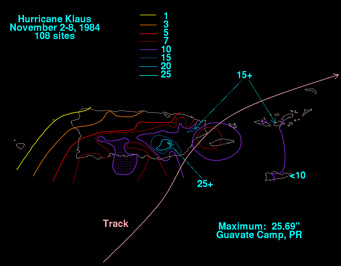
, Tropical Storm Klaus dropped heavy rainfall peaking at 25.69 inches (653 mm) in Guavate Camp in the southeastern part of the island. Much of the southern half of Puerto Rico reported over 7 inches (178 mm). Vieques
Vieques, Puerto Rico
Vieques , in full Isla de Vieques, is an island–municipality of Puerto Rico in the northeastern Caribbean, part of an island grouping sometimes known as the Spanish Virgin Islands...
received around 7 inches (178 mm) of precipitation, while Culebra
Culebra, Puerto Rico
Isla Culebra is an island-municipality of Puerto Rico originally called Isla Pasaje and Isla de San Ildefonso. It is located approximately east of the Puerto Rican mainland, west of St. Thomas and north of Vieques. Culebra is spread over 5 wards and Culebra Pueblo...
experienced over 10 inches (250 mm). The heavy rainfall resulted in freshwater flooding. The strongest winds of the storm remained offshore, and wind gusts peaked at 37 mph (60 km/h) in Roosevelt Roads Naval Station
Roosevelt Roads Naval Station
Roosevelt Roads Naval Station is a former United States military air base in the town of Ceiba, Puerto Rico. The site is run today as José Aponte de la Torre Airport, a public use airport.-History:...
. Winds and rainfall on the island resulted in downed trees and power lines, though damage was minimal. Klaus struck the island on election day
Election Day (United States)
Election Day in the United States is the day set by law for the general elections of public officials. It occurs on the Tuesday after the first Monday in November. The earliest possible date is November 2 and the latest possible date is November 8...
, causing slight disruptions to the process.
Saint John
Saint John, U.S. Virgin Islands
Saint John is an island in the Caribbean Sea and a constituent district of the United States Virgin Islands , an unincorporated territory of the United States. St...
in the United States Virgin Islands
United States Virgin Islands
The Virgin Islands of the United States are a group of islands in the Caribbean that are an insular area of the United States. The islands are geographically part of the Virgin Islands archipelago and are located in the Leeward Islands of the Lesser Antilles.The U.S...
reported over 15 inches (380 mm) of rainfall in association with Tropical Storm Klaus. Both Saint Thomas
Saint Thomas, U.S. Virgin Islands
Saint Thomas is an island in the Caribbean Sea and with the islands of Saint John, Saint Croix, and Water Island a county and constituent district of the United States Virgin Islands , an unincorporated territory of the United States. Located on the island is the territorial capital and port of...
and Saint Croix
Saint Croix, U.S. Virgin Islands
Saint Croix is an island in the Caribbean Sea, and a county and constituent district of the United States Virgin Islands , an unincorporated territory of the United States. Formerly the Danish West Indies, they were sold to the United States by Denmark in the Treaty of the Danish West Indies of...
received around 10 inches (250 mm), while rainfall in the British Virgin Islands
British Virgin Islands
The Virgin Islands, often called the British Virgin Islands , is a British overseas territory and overseas territory of the European Union, located in the Caribbean to the east of Puerto Rico. The islands make up part of the Virgin Islands archipelago, the remaining islands constituting the U.S...
remained below 10 inches (250 mm). Tropical Storm Klaus caused severe flooding and extensive damage throughout the U.S. Virgin Islands. Strong southwesterly winds resulted in gale force winds and rough seas along the southwestern portions of the Leeward Islands
Leeward Islands
The Leeward Islands are a group of islands in the West Indies. They are the northern islands of the Lesser Antilles chain. As a group they start east of Puerto Rico and reach southward to Dominica. They are situated where the northeastern Caribbean Sea meets the western Atlantic Ocean...
. The rough waves caused considerable damage to marine interests in the area. In Anguilla
Anguilla
Anguilla is a British overseas territory and overseas territory of the European Union in the Caribbean. It is one of the most northerly of the Leeward Islands in the Lesser Antilles, lying east of Puerto Rico and the Virgin Islands and directly north of Saint Martin...
, three ships were wrecked. 1 mile (1.6 km) off of Saint Martin
Saint Martin
Saint Martin is an island in the northeast Caribbean, approximately east of Puerto Rico. The 87 km2 island is divided roughly 60/40 between France and the Kingdom of the Netherlands ; however, the Dutch side has the larger population. It is one of the smallest sea islands divided between...
, the rough seas wrecked a cruise ship
Windjammer Barefoot Cruises
Windjammer Barefoot Cruises was a leisure cruise line based in Miami Beach, Florida. Founded in 1947, the company scheduled one and two week cruises in the Caribbean and Central America, using a fleet of sailing ships. The ships were former yachts and commercial vessels that were refurbished as...
. The 60 passengers and 23 crew members swam safely to shore, though one person was hospitalized. Rough seas also damaged local coral reef
Coral reef
Coral reefs are underwater structures made from calcium carbonate secreted by corals. Coral reefs are colonies of tiny living animals found in marine waters that contain few nutrients. Most coral reefs are built from stony corals, which in turn consist of polyps that cluster in groups. The polyps...
s. 10,000 people were affected on the island of Dominica
Dominica
Dominica , officially the Commonwealth of Dominica, is an island nation in the Lesser Antilles region of the Caribbean Sea, south-southeast of Guadeloupe and northwest of Martinique. Its size is and the highest point in the country is Morne Diablotins, which has an elevation of . The Commonwealth...
. There, the storm caused $2 million (1984 USD
United States dollar
The United States dollar , also referred to as the American dollar, is the official currency of the United States of America. It is divided into 100 smaller units called cents or pennies....
, $3.9 million 2006 USD) in damage and resulted in two fatalities. In Antigua
Antigua
Antigua , also known as Waladli, is an island in the West Indies, in the Leeward Islands in the Caribbean region, the main island of the country of Antigua and Barbuda. Antigua means "ancient" in Spanish and was named by Christopher Columbus after an icon in Seville Cathedral, Santa Maria de la...
, strong waves from the hurricane produced severe beach erosion, which endangered a highway behind an eroded beach. Beach erosion was reported in nearby Barbuda
Barbuda
Barbuda is an island in the Eastern Caribbean, and forms part of the state of Antigua and Barbuda. It has a population of about 1,500, most of whom live in the town of Codrington.-Location:...
, as well. The British Virgin Islands sustained moderate damage totaling to $152 million (1984 USD, $315 million 2008 USD). St. Kitts and Nevis also saw much Leeward coastal damage resulting from the storm, the worst impact being the destruction of the Sandy Point town port in Saint Kitts
Saint Kitts
Saint Kitts Saint Kitts Saint Kitts (also known more formally as Saint Christopher Island (Saint-Christophe in French) is an island in the West Indies. The west side of the island borders the Caribbean Sea, and the eastern coast faces the Atlantic Ocean...
.
Aftermath
In AnguillaAnguilla
Anguilla is a British overseas territory and overseas territory of the European Union in the Caribbean. It is one of the most northerly of the Leeward Islands in the Lesser Antilles, lying east of Puerto Rico and the Virgin Islands and directly north of Saint Martin...
, nine ships, including three that were wrecked from the hurricane, were intentionally sunk in 1990 to create an artificial reef. About a month after the storm passed, President
President of the United States
The President of the United States of America is the head of state and head of government of the United States. The president leads the executive branch of the federal government and is the commander-in-chief of the United States Armed Forces....
Ronald Reagan
Ronald Reagan
Ronald Wilson Reagan was the 40th President of the United States , the 33rd Governor of California and, prior to that, a radio, film and television actor....
declared the U.S. Virgin Islands a major disaster area. The declaration permitted use of federal funds for recovery. The Federal Emergency Management Agency
Federal Emergency Management Agency
The Federal Emergency Management Agency is an agency of the United States Department of Homeland Security, initially created by Presidential Reorganization Plan No. 1 of 1978 and implemented by two Executive Orders...
provided an average relief fund of $2,128 (1984 USD, $4,147 2006 USD) per affected person, the smallest return rate for a declared disaster in the Virgin Islands.
Because damage was not significant, the name Klaus was not retired after this year, but a different Hurricane Klaus
Hurricane Klaus
Hurricane Klaus was a minimal Atlantic hurricane that dropped heavy rainfall across the Lesser Antilles in October 1990. The eleventh tropical cyclone and sixth hurricane of the 1990 Atlantic hurricane season, Klaus developed from a tropical wave on October 3 a short distance east of Dominica. It...
in 1990 was retired, and was replaced by Kyle in 1996.